
Shimna River
| Shimna River | |
|---|---|
.JPG) Shimna River in Tollymore Forest Park, September 2010 | |
 Location of mouth within Northern Ireland | |
| Location | |
| Country | Northern Ireland |
| Region | County Down |
| Physical characteristics | |
| Source | |
| • location | Mourne Mountains on the slopes of Ott Mountain |
| • elevation | 430 m (1,410 ft) |
| Mouth | |
• location | Dundrum Bay, Irish Sea |
• elevation | 5 m (16 ft) |
| Length | 11.77 km (7.31 mi)[1] |
| Basin features | |
| Tributaries | |
| • left | Trassey River Spinkwee River Tullybrannigan River |
| • right | Burren River |
The Shimna River (
The Shimna has a history of flooding; the most serious recent flooding was in 2008. There have also been incidents of pollution, and there were serious fish kills in 2004, 2006 and 2009.
Course
The source of the river is in the Mourne Mountains on the slopes of Ott Mountain. The river then flows in a northerly direction into Fofanny Dam. It continues its flow in a north-easterly direction into Tollymore Forest Park where the tributary Spinkwee River and Trassey River join it. The Shimna finally flows to the east, then takes a south easterly direction toward Newcastle where at one point it flows through Tipperary Wood. The final tributaries to join the river prior to it reaching the sea are the Burren River and the Tullybrannigan River, at Islands Park. Near the mouth, as it flows through Castle Park, it widens quite considerably to create a shallow boating pond.
The river's geology, flora and fauna have made it an
Geology
The Shimna is a short spate river, meaning it becomes deep and fast-flowing after periods of rain and is slow, with low water levels in drier weather.[4] In sections of the river where the gradient is low, there are riffles and pools, sandy banks, and pebbles and scattered boulders on the river bed. Along steeper parts there is a faster flow, rapids and cascades, and the bed is made up of bedrock and boulders.[3]
.JPG)
The bedrock of the upper part of the river, located in the Mourne Mountains, is composed of granite formed approximately 50 million years ago (mya).[5] The bedrock of the river as it flows through Tollymore is shale from the Silurian age, more than 400 mya, and it forms step gorges along some sections of the river banks. Dark bands of basalt are found were molten basalt lava was forced through cracks in the bedrock about 60 million years ago. The river bed contains stones and gravel from as far away as Antrim, Tyrone and Scotland, which were carried there by glacial ice sheets during the last ice age.[6]
History
.jpg)
Felix Magennis, a member of the Magennis clan and relative of Hugh Magennis, Lord of Iveagh, built a castle next to the mouth of the Shimna River in 1588. The town is referred to as New Castle in the Annals of the Four Masters in 1433 so it is likely that he built on the site of an existing structure.[7][8][9] Magennis' castle was demolished in 1830.[10][11]

The river is crossed by 16 bridges as it flows through Tollymore Forest Park. The Old Bridge, built by James Hamilton in 1726, is the oldest of the current bridges. The Ivy Bridge was built in 1780 and Foley's Bridge in 1787. Parnell Bridge, named in recognition of Sir John Parnell who visited Tollymore in the late 18th century, was constructed in 1842. It was the last stone bridge to be built in Tollymore. The more recent footbridges are constructed from wood.[12] Castle Bridge is located near the mouth where Main Street crosses the river. It was originally called Fearsat an Chaislein Nui (The Ford or Pass of the Newcastle) and was next to the entrance to the castle. This was replaced by a wider, straighter bridge in the 1890s.[13]
The Hermitage is a small stone shelter built into the side of the gorge, above the river. It was designed by James Hamilton in the 1770s as a place for ladies to shelter while the men fished in the river.[12]
Between 1994 and 2003, five
Flooding
2008
There was major
2020
Major flooding occurred on 25 and 26 August 2020 when the Shimna River burst its banks during Storm Francis.[17] The Northern Ireland Fire and Rescue Service deployed specialist flood rescue teams, and a number of elderly people were evacuated from homes on the Shimna Road and Bryansford Road in Newcastle.[18] In response to the flooding, Infrastructure Minister Nicola Mallon stated that work on a flood alleviation scheme for the Shimna River was due to start in the summer of 2021.[17] She later said this will be brought forward and work on the scheme will start as quickly as possible.[19]
There was also flooding in Tollymore Forest Park, where a number of bridges were washed away.[20]

Flora
The river is nutrient-poor and acidic (pH 4.33) which determines the type of plant life found there.
Other notable species include:
- Rusty feather-moss (Brachythecium plumosum)
- Fox-tail feather-moss (Thamnobryum alopecurum)
- Yellow fringe-moss (Racomitrium aciculare)
- Overleaf pellia (Pellia epiphylla)
The most common trees found along the banks include oak, beech (Fagus sylvatica), ash (Fraxinus excelsior), birch and willow. Rhododendron, elderberry, blackberry, laurel and ivy are also common along parts of the river.[21]
Fauna
A population of feral Mandarin ducks have been present on the river since 1978.[21][24] Kingfishers and grey herons can also be seen.[3][25][26] Otters are common near the mouth of the river.[27]
Angling
The river is partly owned by the
Pollution and fish kills
There have been a number of incidents in recent years where the river has been polluted and fish have been killed. In 2004 a pipe was broken by builders while they were working on the upgrade of the Fofanny water treatment works, near the source of the river. This resulted in
In July 2006, sewage discharge from a pumping station resulted in the death of an estimated 1,400 fish, mostly juveniles.[31] Brian Finn of the Fisheries Conservation Board suggested that there may have been only a small amount of sewage released but the high water temperatures and the low water levels caused by the warm weather at the time increased the fish's vulnerability to pollution.[32][33] The pollution led to the temporary closure of the boating lake and part of the beach near the mouth of the river.[34]
In 2009 there was another major fish kill, with over 200 dead fish found near the Fofanny water treatment works. There were approximately 150 trout and 55 salmon killed. The Northern Ireland Environment Agency investigated the incident and identified a potential source.[35][36] It was revealed that an emergency discharge was carried out at Fofanny Water Treatment Work from 5am to 7am, due to a generator failure. The discharge was stopped as soon as personnel arrived at the site. Northern Ireland Water claimed the discharge was necessary to maintain the drinking water supply from Fofanny Dam. Measures have been since been put in place to prevent a similar incident in the future.[37]
In 2010 a new fish counter was commissioned for the Shimna river and the initial results indicated that fish numbers had reached approximately 76% of the conservation limit (the number of fish required to spawn) in the 2010 season. This is an improvement from the estimated 12% in 2009.[38] However, in 2014 concerns about salmon levels in the river were raised again after it was observed that the number of eggs being laid was still below conservation limits.[39]
Gallery
-
 Newcastle and the Shimna River
 -
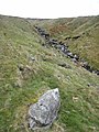 Headwater of the river
 -
 The mouth of the river


References
- ^ a b c "Shimna River ASSI". Retrieved 30 October 2020.
- ^ Joyce, P.W (1910). The origin and history of Irish names of places (1910), Volume II. London Longmans, Green. p. 334.
- ^ a b c d "Shimna River, a special place" (PDF). Retrieved 16 May 2012.
- ^ "The World Around Us at Tollymore Forest Park" (PDF). DARD. p. 9. Retrieved 27 October 2014.
- ^ "Geology of Mourne AONB". DOE. 25 January 2010. Retrieved 14 June 2012.
- ISSN 1753-5271. Archived from the original(PDF) on 28 June 2011.
- ^ Forde, Hugh (1928). Round the Coast of Northern Ireland: Antrim Derry, and Down. R. Carswell. p. 203.
- ^ John Cooke (M.A.) (1902). Handbook for Travellers in Ireland. E. Stanford. p. 87.
- ^ Meginness, John R. (1891). Origin and History of the Magennis Family: with Sketches of the Keylor, Swisher, Marchbank, and Bryan families. Heller Brothers Printing Co.
- ^ "About Newcastle". Newcastle Lifeboat. Archived from the original on 23 October 2014. Retrieved 16 October 2014.
- ^ Stewart, Linda (5 January 2013). "See the Wood for the Trees". Belfast Telegraph. Archived from the original on 28 March 2015. Retrieved 16 October 2014.
- ^ a b McKee, Linda (3 January 2009). "Enjoy a Tolly good walk in the heart of Narnia country; WALK THIS WAY". Belfast Telegraph. Archived from the original on 28 March 2015. Retrieved 16 October 2014.
- ^ "Proceedings". The Journal of the Royal Society of Antiquaries of Ireland. 22: 347. 1892.
- JSTOR 20568361.
- ^ a b Newcastle August 2008 Flood Non Technical Flood Report, DARD Rivers Agency, September 2009
- ^ "DARD Rivers Agency To Run Study To Alleviate Flooding From Shimna River in Newcastle". Down News. 7 October 2014. Retrieved 22 October 2014.
- ^ a b "Storm Francis: Nichola Mallon 'committed to Newcastle flood scheme'". BBC News. 26 August 2020. Retrieved 13 October 2020.
- ^ "Storm Francis: 37 people rescued from flooding". BBC News. 25 August 2020. Retrieved 13 October 2020.
- ISSN 0307-1235. Retrieved 13 October 2020.
- ^ "Flash flood nightmare". 26 August 2020. Retrieved 13 October 2020.
- ^ JSTOR 25536032.
- ^ a b "Key information about Shimna River". Retrieved 16 May 2012.
- ^ "Reference Condition Descriptions for Northern Ireland River Types" (PDF). Retrieved 16 May 2012.
- ^ Malcolm Ogilvie and the Rare breeding birds panel (1999). "Non-Native birds breeding in the UK in 1996" (PDF). British Birds. 92: 179–180.
- ^ "Tollymore Forest Park". NI Direct. Retrieved 14 October 2014.
- ^ Stewart, Linda (6 May 2013). "Eat Up the Miles on a Gastronomic Bike Tour of Mournes". Belfast Telegraph. Archived from the original on 28 March 2015. Retrieved 16 October 2014.
- ^ "Wetlands and Rivers". Mourne Heritage Trust. Retrieved 14 October 2014.
- ^ "Fishing". Down District Council. Retrieved 27 October 2014.
- ^ Clancy, Paddy (13 June 2011). "Specimen sea trout caught off Donegal". The Irish Times. Archived from the original on 28 March 2015. Retrieved 16 October 2014.
- ^ "Investigation over river incident". BBC. 23 October 2004. Retrieved 16 June 2012.
- ^ McAleese, Deborah (19 July 2006). "Water Service is under pressure to explain sewage leak". Belfast Telegraph. Archived from the original on 28 March 2015. Retrieved 16 October 2014.
- ^ "River pollution kills 3,000 fish". BBC. 17 July 2006. Retrieved 16 June 2012.
- ^ Murray, Gemma (18 July 2006). "Fish Die in River Sewage Spillage". The News Letter. Belfast =.
- ^ Moulton, Emily (18 July 2006). "Newcastle beach closed after discovery of raw sewage". Belfast Telegraph. Archived from the original on 28 March 2015. Retrieved 20 October 2014.
- ^ "Mourne river fish kill". Belfast Telegraph. 22 September 2009. Retrieved 16 June 2012.
- ^ "Hundreds of fish are found dead". BBC. 21 September 2009. Retrieved 16 June 2012.
- ^ "Meeting Record of the Carlingford & Mourne Catchment Stakeholder Group Meeting" (PDF). DOE. 21 October 2009. Retrieved 16 June 2012.
- ^ "Scientific and technical input to salmon conservation consultation". Retrieved 16 June 2012.
- ^ Stewart, Linda (1 April 2014). "Fears as Salmon Fail to Return; Just Three in 100 That Migrate from River Bush Come Back to Spawn". Belfast Telegraph. Archived from the original on 28 March 2015. Retrieved 16 October 2014.