
Shu'fat Camp

Shu'fat, or more commonly Shuafat (
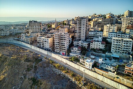
Often, the entire area within the municipal boundaries of Jerusalem that is located beyond the Shu'fat refugee camp checkpoint, is referred to as "Shu'fat Refugee Camp." However, in reality, the area of the refugee camp (under UNRWA responsibility) constitutes only a small part of this territory, characterized by low-rise construction. To the west of the refugee camp, still within the area beyond the separation barrier, lies Ras Khamis; to the south of the refugee camp is Ras Shehadeh; and to the east of the camp is Dahiyat al-Salam, extending eastward to the municipal boundary of the city, beyond which lies the village of Anata (located outside the municipal area). The neighborhoods surrounding the camp are characterized by dense high-rise construction. To the north, the refugee camp extends to the separation barrier, just a few hundred meters from the Pisgat Ze'ev neighborhood.
Shuafat refugee camp
In the wake of the


In 1964, a decision was made to move the refugees to a new camp constructed on mostly Jewish land near Shuafat.[2] Most of the refugees refused to move, since it would mean losing their livelihood, the market and the tourists, as well as reducing their access to the holy sites.[2] In the end, many of the refugees were moved to Shuafat by force during 1965 and 1966.[1][2]
History
After the 1967 Six-Day War, East Jerusalem, including the town and refugee camp, was occupied and later annexed by Israel, in a move not internationally recognized, and were incorporated into the Jerusalem municipal district.[3][4] The residents were offered Israeli citizenship, but most refused it as they considered the area to be illegally occupied. Many accepted permanent residency status instead.[4]
The Shuafat refugee camp is the only
In a survey conducted as part of the research for the book Negotiating Jerusalem (2000), it was reported that 59% of Israeli Jews supported redefining the borders of the city of Jerusalem so as to exclude Arab settlements such as Shuafat, in order to ensure a "Jewish majority" in Jerusalem.[7]
In July 2001, the Israeli authorities destroyed 14 homes under construction in Shuafat on the orders of then mayor
As prime minister, Ehud Olmert questioned whether the annexation of areas like Shuafat into the Jerusalem area was necessary.[10] The Israeli initiative to transfer control of the area to the Palestinian National Authority led to a split in the community: a camp official favored being under Palestinian sovereignty, while the neighborhood's mukhtar rejected the plan, citing his residents' participation in Israeli elections as well as the danger of Palestinian rocket attacks on Israel[11]
Urban development
In 2012, Sorbonne scholar professor Sylvaine Bulle cited the Shuafat refugee camp for its urban renewal dynamic, seeing it as an example of a creative adaptation to the fragmented space of the camps towards creating a bricolage city, with businesses relocating from east Jerusalem there and new investment in commercial projects.[12]
Gallery
-

-
 Dahiyat al-Salam


References
- ^ a b Meron Benvenisti (1976). Jerusalem: The Torn City. Isratypeset. p. 70.
- ^ a b c d e f Avi Plascov (1981). The Palestinian Refugees in Jordan 1948–1957. Frank Cass. p. 171.
- ^ Noah Browning, 'In bleak Arab hinterland, hints of Jerusalem's partition,' Reuters December 20, 2013.
- ^ a b c Isabel Kershner (June 5, 2007). "Under a Divided City, Evidence of a Once United One". The New York Times. Retrieved 2008-01-29.
- ^ "New checkpoint opened at entrance to Shuafat". The Jerusalem Post. December 2011. Retrieved 2012-02-20.
- ^ "Jerusalem Neighborhood Profile: Shuafat Refugee Camp". Ir Amim. August 2006. Archived from the original (DOC) on 2011-08-22. Retrieved 2008-02-01.
- ISBN 0-7914-4537-2.
- Independent.co.uk.
- ^ Tracy Wilkinson (July 10, 2001). "Israel Razes 14 Arab Homes at Refugee Camp". Los Angeles Times. p. in print edition A-4. Retrieved 2008-09-07.
- ^ Meranda, Amnon (October 15, 2007). "Olmert hints at possible concessions in Jerusalem". Ynetnews. Ynet. Retrieved 2008-02-01.
- ^ "Shuafat area residents split over plan to divide Jerusalem in two". The Jerusalem Post. October 2007. Retrieved 2012-02-20.
- ^ Esther Zandberg (2008-10-23). "Their Shoafat outshines her Paris". HAARETZ. Retrieved 2012-12-04.
External links
- Welcome To Shu'fat R.C.
- Camp profile on UNWRAwebsite
- Shuafat Camp Website Archived 2018-04-20 at the Wayback Machine
Palestine refugee camps locations and populations as of 2015[1] | |||||||||||||||||||||||||||||||||||||||||||||||||||||||||||||||||||||||||||||||||||||||||||||||||||||||||||||||||||||||||||||||||
|---|---|---|---|---|---|---|---|---|---|---|---|---|---|---|---|---|---|---|---|---|---|---|---|---|---|---|---|---|---|---|---|---|---|---|---|---|---|---|---|---|---|---|---|---|---|---|---|---|---|---|---|---|---|---|---|---|---|---|---|---|---|---|---|---|---|---|---|---|---|---|---|---|---|---|---|---|---|---|---|---|---|---|---|---|---|---|---|---|---|---|---|---|---|---|---|---|---|---|---|---|---|---|---|---|---|---|---|---|---|---|---|---|---|---|---|---|---|---|---|---|---|---|---|---|---|---|---|---|---|
| |||||||||||||||||||||||||||||||||||||||||||||||||||||||||||||||||||||||||||||||||||||||||||||||||||||||||||||||||||||||||||||||||
References
| |||||||||||||||||||||||||||||||||||||||||||||||||||||||||||||||||||||||||||||||||||||||||||||||||||||||||||||||||||||||||||||||||
| Subdistrict | Jerusalem J1 (Territories of East Jerusalem unilaterally annexed by Israel in its Jerusalem Municipality) |  |
|---|---|---|
| Cities | ||
| Municipalities | ||
| Villages | ||
| Refugee camps | ||
| Authority control databases: National |
|---|