Siberia
It has been suggested that North Asia be merged into this article. (Discuss) Proposed since November 2023. |
Siberia
Сибирь | |
|---|---|
US$ 480 billion) | |
| • Per capita | ₽953,871 (US$12951) |
Siberia (/saɪˈbɪəriə/ sy-BEER-ee-ə; Russian: Сибирь, romanized: Sibir', IPA: [sʲɪˈbʲirʲ] ⓘ) is an extensive geographical region comprising all of North Asia, from the Ural Mountains in the west to the Pacific Ocean in the east.[3] It has formed part of the sovereign territory of Russia and its predecessor states since the centuries-long conquest of Siberia, which began with the fall of the Khanate of Sibir in the late 16th century and concluded with the annexation of Chukotka in 1778. Siberia is vast and sparsely populated, covering an area of over 13.1 million square kilometres (5,100,000 sq mi), but home to roughly a quarter of Russia's population. Novosibirsk and Omsk are the largest cities in the area.[4]
Because Siberia is a geographic and historic concept and not a political entity, there is no single precise definition of its territorial borders. Traditionally, Siberia spans the entire expanse of land from the
Siberia is known for its long, harsh winters, with a January average of −25 °C (−13 °F).
Etymology
The origin of the name is uncertain.
Some sources say that "Siberia" originates from the
Mongolist György Kara posits that "Siberia" is derived from a Mongolic word "sibir", cognate with modern Buryat "sheber" or "dense forest".[14]
History
Prehistory
Siberia in
The
The region has
At least three species of human lived in southern Siberia around 40,000 years ago:
Late Paleolithic southern Siberians appear to be related to paleolithic Europeans and the paleolithic
Early history

During past millennia, different groups of
With the breakup of the Golden Horde, the autonomous Khanate of Sibir formed in the late-15th century. Turkic-speaking Yakut migrated north from the Lake Baikal region under pressure from the Mongol tribes during the 13th to 15th century.[31] Siberia remained a sparsely populated area. Historian John F. Richards wrote: "... it is doubtful that the total early modern Siberian population exceeded 300,000 persons".[32]
The growing power of
Russian Empire


By the mid-17th century, Russia had established areas of control that extended to the Pacific Ocean. Some 230,000 Russians had settled in Siberia by 1709.[34] Siberia became one of the destinations for sending internal exiles. Exile was the main Russian punitive practice with more than 800,000 people exiled during the nineteenth century.[35][36]
The first great modern change in Siberia was the
At 7:15 a.m. on 30 June 1908, the
Soviet Union
In the early decades of the
Half a million (516,841) prisoners died in camps from 1941 to 1943[43] during World War II.[citation needed] At other periods, mortality was comparatively lower.[44] The size, scope, and scale of the Gulag slave-labour camps remain subjects of much research and debate. Many Gulag camps operated in extremely remote areas of northeastern Siberia. The best-known clusters included Sevvostlag (the North-East Camps) along the Kolyma and Norillag near Norilsk, where 69,000 prisoners lived in 1952.[45] Major industrial cities of Northern Siberia, such as Norilsk and Magadan, developed from camps built by prisoners and run by former prisoners.[46]
Geography
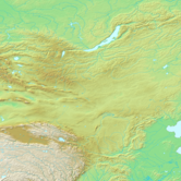
| Physical map of Northern Asia (the map also contains parts of Central and East Asia). | ||
|---|---|---|

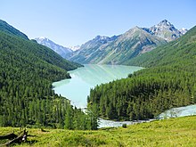


Siberia spans an area of 13.1 million square kilometres (5,100,000 sq mi), covering the vast majority of Russia's total territory, and almost 9% of Earth's land surface (148,940,000 km2, 57,510,000 sq mi). It geographically falls in Asia, but is culturally and politically considered European, since it is a part of Russia.[7] Major geographical zones within Siberia include the West Siberian Plain and the Central Siberian Plateau.
Eastern and central Sakha comprises numerous north–south mountain ranges of various ages. These mountains extend up to almost 3,000 metres (9,800 ft), but above a few hundred metres they are almost completely devoid of vegetation. The Verkhoyansk Range was extensively glaciated in the Pleistocene, but the climate was too dry for glaciation to extend to low elevations. At these low elevations are numerous valleys, many of them deep and covered with larch forest, except in the extreme north where the tundra dominates. Soils are mainly turbels (a type of gelisol). The active layer tends to be less than one metre deep, except near rivers.
The highest point in Siberia is the active volcano Klyuchevskaya Sopka, on the Kamchatka Peninsula. Its peak reaches 4,750 metres (15,580 ft).
Mountain ranges
- Altai Mountains
- Anadyr Highlands
- Baikal Mountains
- Khamar-Daban
- Chersky Range
- Chukotka Mountains
- Dzhugdzhur Mountains
- Kolyma Mountains
- Koryak Mountains
- Sayan Mountains
- Tannu-Ola Mountains
- Ural Mountains
- Verkhoyansk Mountains
- Yablonoi Mountains
Geomorphological regions
Lakes and rivers
Grasslands
- Ukok Plateau—part of a UNESCO World Heritage Site[47]
Geology
The West Siberian Plain, consisting mostly of

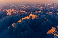
The Central Siberian Plateau is an ancient
The Lena-Tunguska petroleum province includes the Central Siberian platform (some authors refer to it as the "Eastern Siberian platform"), bounded on the northeast and east by the
Climate


|
|
polar desert
tundra
alpine tundra
taiga
montane forest |
temperate forest zone in the south.
|
The climate of Siberia varies dramatically, but it typically has warm but short summers and long, brutally cold winters. On the north coast, north of the Arctic Circle, there is a very short (about one month long) summer.
Almost all the population lives in the south, along the route of the Trans-Siberian Railway. The climate in this southernmost part is humid continental climate (Köppen Dfa/Dfb or Dwa/Dwb) with cold winters but fairly warm summers lasting at least four months. The annual average temperature is about 0.5 °C (32.9 °F). January averages about −20 °C (−4 °F) and July about +19 °C (66 °F), while daytime temperatures in summer typically exceed 20 °C (68 °F).[51][52] With a reliable growing season, an abundance of sunshine and exceedingly fertile chernozem soils, southern Siberia is good enough for profitable agriculture, as was demonstrated in the early 20th century.
By far the most commonly occurring climate in Siberia is continental subarctic (Koppen Dfc, Dwc, or Dsc), with the annual average temperature about −5 °C (23 °F) and an average for January of −25 °C (−13 °F) and an average for July of +17 °C (63 °F),[53] although this varies considerably, with a July average about 10 °C (50 °F) in the taiga–tundra ecotone. The business-oriented website and blog Business Insider lists Verkhoyansk and Oymyakon, in Siberia's Sakha Republic, as being in competition for the title of the Northern Hemisphere's Pole of Cold. Oymyakon is a village which recorded a temperature of −67.7 °C (−89.9 °F) on 6 February 1933. Verkhoyansk, a town further north and further inland, recorded a temperature of −69.8 °C (−93.6 °F) for three consecutive nights: 5, 6 and 7 February 1933. Each town is alternately considered the Northern Hemisphere's Pole of Cold – the coldest inhabited point in the Northern hemisphere. Each town also frequently reaches 30 °C (86 °F) in the summer, giving them, and much of the rest of Russian Siberia, the world's greatest temperature variation between summer's highs and winter's lows, often well over 94–100+ °C (169–180+ °F) between the seasons.[54][failed verification]
Southwesterly winds bring warm air from Central Asia and the Middle East. The climate in West Siberia (Omsk, or Novosibirsk) is several degrees warmer than in the East (Irkutsk, or Chita) where in the north an extreme winter subarctic climate (Köppen Dfd, Dwd, or Dsd) prevails. But summer temperatures in other regions can reach +38 °C (100 °F). In general, Sakha is the coldest Siberian region, and the basin of the Yana has the lowest temperatures of all, with permafrost reaching 1,493 metres (4,898 ft). Nevertheless, Imperial Russian plans of settlement never viewed cold as an impediment. In the winter, southern Siberia sits near the center of the semi-permanent Siberian High, so winds are usually light in the winter.
| Climate data for Novosibirsk, Siberia's largest city | |||||||||||||
|---|---|---|---|---|---|---|---|---|---|---|---|---|---|
| Month | Jan | Feb | Mar | Apr | May | Jun | Jul | Aug | Sep | Oct | Nov | Dec | Year |
| Mean daily maximum °C (°F) | −12.2 (10.0) |
−10.3 (13.5) |
−2.6 (27.3) |
8.1 (46.6) |
17.5 (63.5) |
24.0 (75.2) |
25.7 (78.3) |
22.2 (72.0) |
16.6 (61.9) |
6.8 (44.2) |
−2.9 (26.8) |
−8.9 (16.0) |
7.0 (44.6) |
| Daily mean °C (°F) | −16.2 (2.8) |
−14.7 (5.5) |
−7.2 (19.0) |
3.2 (37.8) |
11.6 (52.9) |
18.2 (64.8) |
20.2 (68.4) |
17.0 (62.6) |
11.5 (52.7) |
3.4 (38.1) |
−6 (21) |
−12.7 (9.1) |
2.4 (36.3) |
| Mean daily minimum °C (°F) | −20.1 (−4.2) |
−19.1 (−2.4) |
−11.8 (10.8) |
−1.7 (28.9) |
5.6 (42.1) |
12.3 (54.1) |
14.7 (58.5) |
11.7 (53.1) |
6.4 (43.5) |
0.0 (32.0) |
−9.1 (15.6) |
−16.4 (2.5) |
−2.3 (27.9) |
| Average precipitation mm (inches) | 19 (0.7) |
14 (0.6) |
15 (0.6) |
24 (0.9) |
36 (1.4) |
58 (2.3) |
72 (2.8) |
66 (2.6) |
44 (1.7) |
38 (1.5) |
32 (1.3) |
24 (0.9) |
442 (17.4) |
| Source: [55] | |||||||||||||
Global warming
Researchers, including Sergei Kirpotin at
Since 1988, experimentation at Pleistocene Park has proposed to restore the grasslands of prehistoric times by conducting research on the effects of large herbivores on permafrost, suggesting that animals, rather than climate, maintained the past ecosystem. The nature reserve park also conducts climatic research on the changes expected from the reintroduction of grazing animals or large herbivores, hypothesizing that a transition from tundra to grassland would lead to a net change in energy emission to absorption ratios.[59]
According to Vasily Kryuchkov, approximately 31,000 square kilometers of the Russian Arctic has subjected to severe environmental disturbance.
Fauna
Birds
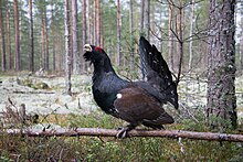
Order Galliformes
Family Tetraonidae
- Hazel grouse[60]
- Siberian grouse[61]
- Black grouse[62]
- Black-billed capercaillie[63]
- Western capercaillie[64]
- Willow ptarmigan[65]
- Rock ptarmigan[66]
Family Phasianidae
Mammals
Order Artiodactyla


- Moose
- Bactrian camel
- Wisent (European bison)
- Red deer
- Wild boar
- Siberian roe deer
- Manchurian wapiti[67]
- Siberian musk deer[68]
Order Carnivora
Family Canidae
Family Felidae

Family Mustelidae
- Least weasel
- Stoat
- Mountain weasel
- Siberian weasel
- Steppe polecat
- Sable
- Eurasian river otter
- Asian badger
- Wolverine
Family Ursidae
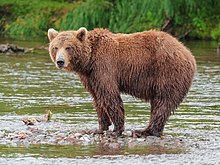
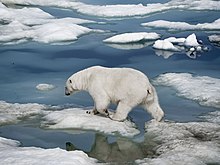
Flora

Politics
Notable sovereign states in Siberia
- Xianbei state (1st–3rd century CE)
- First Turkic Khaganate (6th–7th century)
- Eastern Turkic Khaganate (7th century)
- Second Turkic Khaganate (7th–8th century)
- Mongol Empire (13th–14th century)
- Khanate of Sibir (1468–1598)
- Tsardom of Russia (1598–1721)
- Russian Empire (1721–1917)
- Russian Republic (1917–1918)
- Russian Socialist Federative Soviet Republic (1918–1922)
- Far Eastern Republic (1920–1922)
- Tuvan People's Republic (1921–1944)
- Soviet Union (1922–1991)
- Russian Soviet Federative Socialist Republic (1922–1991)
- Russian Federation(1991–present)
Borders and administrative division
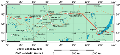
The term "Siberia" has both a long history and wide significance, and association. The understanding, and association of "Siberia" have gradually changed during the ages. Historically, Siberia was defined as the whole part of Russia and North Kazakhstan to the east of Ural Mountains, including the Russian Far East. According to this definition, Siberia extended eastward from the Ural Mountains to the Pacific coast, and southward from the Arctic Ocean to the border of Central Asia and the national borders of both Mongolia and China.[75]
Soviet-era sources (Great Soviet Encyclopedia and others)[5] and modern Russian ones[76] usually define Siberia as a region extending eastward from the Ural Mountains to the watershed between Pacific and Arctic drainage basins, and southward from the Arctic Ocean to the hills of north-central Kazakhstan and the national borders of both Mongolia and China. By this definition, Siberia includes the federal subjects of the Siberian Federal District, and some of the Ural Federal District, as well as Sakha (Yakutia) Republic, which is a part of the Far Eastern Federal District. Geographically, this definition includes subdivisions of several other subjects of Urals and Far Eastern federal districts, but they are not included administratively. This definition excludes Sverdlovsk Oblast and Chelyabinsk Oblast, both of which are included in some wider definitions of Siberia.
Other sources may use either a somewhat wider definition that states the Pacific coast, not the watershed, is the eastern boundary (thus including the whole Russian Far East), as well as all Northern Kazakhstan is its subregion in the south-west[3] or a somewhat narrower one that limits Siberia to the Siberian Federal District (thus excluding all subjects of other districts).[77] In Russian, 'Siberia' is commonly used as a substitute for the name of the federal district by those who live in the district itself, but less commonly used to denote the federal district by people residing outside of it. Due to the different interpretations of Siberia, starting from Tyumen, to Chita, the territory generally defined as 'Siberia', some people will define themselves as 'Siberian', while others not.
A number of factors in recent years, including the fomenting of Siberian separatism have made the definition of the territory of Siberia a potentially controversial subject.
| Subject | Administrative center |
|---|---|
| Ural Federal District | |
| Khanty-Mansiysk | |
| Kurgan | |
| Tyumen | |
| Salekhard | |
| Siberian Federal District | |
| Barnaul | |
| Gorno-Altaysk | |
| Irkutsk | |
| Abakan | |
| Kemerovo | |
| Krasnoyarsk | |
| Novosibirsk | |
| Omsk | |
| Tomsk | |
| Kyzyl | |
| Far Eastern Federal District | |
| Ulan-Ude | |
Sakha (Yakutia)
|
Yakutsk |
| Chita | |


Major cities
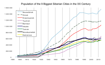
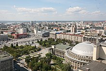
The most populous city of Siberia, as well as the third most populous city of Russia, is the city of Novosibirsk. Present-day Novosibirsk is an important business, science, manufacturing and cultural center of the Asian part of Russia.
Omsk played an important role in the Russian Civil War serving as a provisional Russian capital, as well in the expansion into and governing of Central Asia. In addition to its cultural status, it has become a major oil-refining, education, transport and agriculture hub.
Other historic cities of Siberia include Tobolsk (the first capital and the only kremlin in Siberia), Tomsk (formerly a wealthy merchant's town) and Irkutsk (former seat of Eastern Siberia's governor general, near lake Baikal).
Other major cities include: Barnaul, Kemerovo, Krasnoyarsk, Novokuznetsk, Tyumen.
Wider definitions of geographic Siberia also include the cities of: Chelyabinsk and Yekaterinburg in the Urals, Khabarovsk and Vladivostok in the Russian Far East, and even Petropavlovsk in Kazakhstan and Harbin in China.
Economy

Novosibirsk is the largest by population and the most important city for the Siberian economy; with an extra boost since 2000 when it was designated a regional center for the executive bureaucracy (Siberian Federal District). Omsk is a historic and currently the second largest city in the region, and since 1950s hosting Russia's largest oil refinery.
Siberia is extraordinarily rich in minerals, containing ores of almost all economically valuable metals. It has some of the world's largest deposits of nickel, gold, lead, coal, molybdenum, gypsum, diamonds, diopside, silver and zinc, as well as extensive unexploited resources of oil and natural gas.[80] Around 70% of Russia's developed oil fields are in the Khanty-Mansiysk region.[81] Russia contains about 40% of the world's known resources of nickel at the Norilsk deposit in Siberia. Norilsk Nickel is the world's biggest nickel and palladium producer.[82]
Siberian agriculture is severely restricted by the short growing season of most of the region. However, in the southwest where soils consist of exceedingly fertile black earths and the climate is a little more moderate, there is extensive cropping of wheat, barley, rye and potatoes, along with the grazing of large numbers of sheep and cattle. Elsewhere food production, owing to the poor fertility of the podzolic soils and the extremely short growing seasons, is restricted to the herding of reindeer in the tundra—which has been practiced by natives for over 10,000 years.[citation needed] Siberia has the world's largest forests. Timber remains an important source of revenue, even though many forests in the east have been logged much more rapidly than they are able to recover. The Sea of Okhotsk is one of the two or three richest fisheries in the world owing to its cold currents and very large tidal ranges, and thus Siberia produces over 10% of the world's annual fish catch, although fishing has declined somewhat since the collapse of the USSR in 1991.[83]
Reported in 2009, the development of renewable energy in Russia is held back by the lack of a conducive government policy framework,[84][needs update] As of 2011[update], Siberia still offers special opportunities for off-grid renewable energy developments. Remote parts of Siberia are too costly to connect to central electricity and gas grids, and have therefore historically been supplied with costly diesel, sometimes flown in by helicopter. In such cases renewable energy is often cheaper.[85]
Sport

The
Russia's third most popular sport,
The 2019 Winter Universiade was hosted by Krasnoyarsk.
Demographics
| Ethnicity | Population | % |
|---|---|---|
| Slavic | 18,235,471 | 86.2% |
| Turkic | 1,704,665 | 8.1% |
| Mongol | 454,312 | 2.1% |
Uralic
|
131,430 | 0.6% |
| Other | 637,992 | 3.0% |
According to the

The largest ethnic group in Siberia is Slavic-origin
) or northern Indigenous people. Slavic-origin Russians outnumber all of the Indigenous peoples combined, except in the Republics of Tuva and Sakha.According to the 2002 census there are 500,000
About seventy percent of Siberia's people live in cities, mainly in apartments.[99] Many people also live in rural areas, in simple, spacious, log houses. Novosibirsk[100] is the largest city in Siberia, with a population of about 1.6 million. Tobolsk, Tomsk, Tyumen, Krasnoyarsk, Irkutsk, and Omsk are the older, historical centers.
Religion
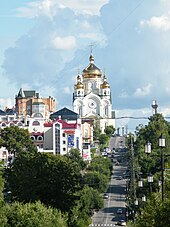
There are a variety of beliefs throughout Siberia, including
Tradition regards Siberia the archetypal home of
Transport
Many cities in northern Siberia, such as Petropavlovsk-Kamchatsky, cannot be reached by road, as there are virtually none connecting from other major cities in Russia or Asia. Siberia can be reached through the Trans-Siberian Railway. The Trans-Siberian Railway operates from Moscow in the west to Vladivostok in the east. Cities that are located far from the railway are reached by air or by the separate Baikal–Amur Railway (BAM).
Culture
Cuisine
See also
References
- ^ "Предварительная оценка численности постоянного населения на 1 января 2023 г." Federal State Statistics Service. Archived from the original on 1 February 2023. Retrieved 21 February 2023.
- ^ "Валовой региональный продукт по субъектам Российской Федерации в 2016-2021гг".
- ^ a b c "Siberia". Encyclopædia Britannica Online. Retrieved 22 September 2021.
- ^ "The Largest Cities in Siberia". August 2017.
- ^ a b Сибирь — Большая советская энциклопедия (The Great Soviet Encyclopedia, in Russian)
- ^ "Arctic Oscillation and Polar Vortex Analysis and Forecasts". Atmospheric and Environmental Research, Verisk Analytics. Retrieved 20 May 2018.
- ^ ISBN 9780199754182.
- ^ "ВПН-2010". Perepis-2010.ru (in Russian). Archived from the original on 18 January 2012. Retrieved 3 April 2016.
- ^ "ВПН-2010". Gks.ru (in Russian). Archived from the original on 15 March 2013. Retrieved 3 April 2016.
- ^ "Siberia".
- ^ ISBN 978-0-631-23591-0. Retrieved 28 December 2013.
- ^ Czaplicka, Marie Antoinette (1914). Aboriginal Siberia : a study in social anthropology. Oxford : Clarendon Press. p. 20.
- ^ Baikaloff, Anatole (December 1950). "Notes on the origin of the name "Siberia"". Slavonic and East European Review. 29 (72): 288.
- ^ "The Multilingual Far East: An Interview with Professor György Kara". Robert F. Byrnes Russian and East European Institute. Retrieved 11 September 2023.
- ISBN 978-1-78969-648-6.
Inv. nr.Si. 1727- 1/69, 1/70
- ^ Francfort, Henri-Paul (1 January 2020). "Sur quelques vestiges et indices nouveaux de l'hellénisme dans les arts entre la Bactriane et le Gandhāra (130 av. J.-C.-100 apr. J.-C. environ)". Journal des Savants: 37.
- ^ Ollermann, Hans (22 August 2019). "Belt Plaque with a Bear Hunt. From Russia (Siberia). Gold. 220-180 B.C. The State Hermitage Museum, St. Petersburg, Russia".
- S2CID 247459291.
- ^ "Yellowstone's Super Sister". Archived from the original on 14 March 2005. Retrieved 17 April 2010.
[...] the Siberian Traps is the prime suspect in wiping out 90 percent of all living species 251 million years ago – the most severe extinction event in Earth's history.
. Discovery Channel. - ]
- ^ "Meet this extinct cave lion, at least 10,000 years old – world exclusive". siberiantimes.com. Retrieved 30 January 2016.
- PMID 34671161.
- ^ " DNA identifies new ancient human dubbed 'X-woman'," BBC News. 25 March 2010.
- ISBN 9780521195225.
In early 2010, researchers published a complete mitochondrial genome sequence retrieved from a hominin excavated from the Denisova cave in Siberia....The results demonstrated that the Denisovan lineage diverged early from the modern humans and Neanderthals
- ^ "Jomon Culture and the peopling of the Japanese archipelago: advancements in the fields of morphometrics and ancient DNA". ResearchGate. Retrieved 18 August 2019.
- ISBN 9781786076236.|
- ISBN 978-1-5387-4971-5.
- ^ Sapiens (8 February 2022). "A Genetic Chronicle of the First Peoples in the Americas". SAPIENS. Retrieved 29 October 2022.
- ^ Gibbons, Ann (10 June 2015). "Nomadic herders left a strong genetic mark on Europeans and Asians". Science. AAAS.
- ^
Naumov, Igor V. (2006). "The Mongols in Siberia". In Collins, David Norman (ed.). The History of Siberia. Routledge Studies in the History of Russia and Eastern Europe. Translated by Collins, David Norman. London: Routledge. p. 44. ISBN 9781134207039. Retrieved 11 June 2019.
In 1207 Chinggis Khan sent his troops north under the command of his elder son Jochi to subjugate the 'forest peoples'. Jochi was able to do so in the space of three years. The only exception was the remote northern tribes. Most of Siberia became part of the Mongol Empire.
- S2CID 31651899.
- ^ Richards, 2003 p. 538.
- ^ Asia ex magna Orbis terrae descriptione Gerardi Mercatoris desumpta, studio & industria G.M. Iunioris
- ^ Sean C. Goodlett. "Russia's Expansionist Policies I. The Conquest of Siberia". Falcon.fsc.edu. Archived from the original on 11 May 2011. Retrieved 15 May 2010.
- ^ For example: Prison without a roof
- ^
Barker, Adele Marie (2010). Barker, Adele Marie; Grant, Bruce (eds.). The Russia Reader: History, Culture, Politics. The World Readers. Durham, North Carolina: Duke University Press. p. 441. ISBN 9780822346487. Retrieved 11 June 2019.
Throughout Russian history there is a long-standing tradition of imprisoning and sentencing to internal exile (within the country proper) political and religious dissidents. [...] Among those sentenced to internal exile were [...] the Decembrists [...]. Several were executed; others were exiled to Siberia, the Far East, and Kazakhstan.
- JSTOR 1848991.
- ISBN 0-8047-2701-5
- ^ Fiona Hill, Russia — Coming In From the Cold? Archived 24 April 2013 at the Wayback Machine, The Globalist, 23 February 2004.
- .
- ISBN 0-19-518769-5
- ^ Robert Conquest in "Victims of Stalinism: A Comment," Europe-Asia Studies, Vol. 49, No. 7 (Nov. 1997), pp. 1317–1319 states: "We are all inclined to accept the Zemskov totals (even if not as complete) with their 14 million intake to Gulag 'camps' alone, to which must be added four to five million going to Gulag 'colonies', to say nothing of the 3.5 million already in, or sent to, 'labour settlements'. However taken, these are surely 'high' figures."
- ^ Zemskov, "Gulag," Sociologičeskije issledovanija, 1991, No. 6, pp. 14–15.
- ISBN 0-674-07608-7– "300,000 known deaths in the camps from 1934 to 1940."
- ^ Courtois and Kramer (1999), Livre noir du Communisme, p.239.
- ^
Chamberlain, Lesley (27 April 2003). "Dark side of the moon". Arlindo-correia.org. Retrieved 11 June 2019.
Today's major industrial cities of Noril'sk, Vorkuta, Kolyma and Magadan, were camps originally built by prisoners and run by ex-prisoners.
- ^ "Altai: Saving the Pearl of Siberia". Pacific Environment. Archived from the original on 22 March 2007. Retrieved 30 November 2006.
- ^ Lioubimtseva E.U., Gorshkov S.P. & Adams J.M.; A Giant Siberian Lake During the Last Glacial: Evidence and Implications; Oak Ridge National laboratory Archived 13 December 2006 at the Wayback Machine
- ^ C. Michael Hogan. 2011. Taiga. eds. M.McGinley & C.Cleveland. Encyclopedia of Earth. National Council for Science and the Environment. Washington DC
- ^ ISBN 0891813063
- ^ "Novosibirsk climate". Worldclimate.com. 4 February 2007. Retrieved 15 May 2010.
- ^ "Omsk climate". Worldclimate.com. 4 February 2007. Retrieved 15 May 2010.
- ^ "Kazachengoye climate". Worldclimate.com. 4 February 2007. Retrieved 15 May 2010.
- ^ Badkar, Mamta (6 February 2014). "This Tiny Town In Russia Is The Most Miserable Place In The World". Business Insider. Retrieved 28 August 2021.
- ^ Гидрометцентр России (in Russian). Archived from the original on 27 June 2008. Retrieved 8 January 2009.
- ^ Ian Sample, "Warming hits 'tipping point'". The Guardian, 11 August 2005.
- ^ Connor, Steve (23 September 2008). "Exclusive: The methane time bomb". The Independent. Retrieved 3 October 2008.
- ^ N. Shakhova, I. Semiletov, A. Salyuk, D. Kosmach, and N. Bel'cheva (2007), Methane release on the Arctic East Siberian shelf, Geophysical Research Abstracts, 9, 01071.
- ^ Sergey A. Zimov (6 May 2005): "Pleistocene Park: Return of the mammoths' ecosystem" In: Science, pages 796–798. Article also to be found in www.pleistocenepark.ru/en/ – Materials. Archived 3 November 2016 at the Wayback Machine Retrieved 5 May 2013.
- ^ "Northern Hazelhen (Tetrastes bonasia). Photo Gallery.Birds of Siberia". sibirds.ru. Retrieved 18 June 2020.
- ^ "Siberian Grouse (Falcipennis falcipennis). Photo Gallery.Birds of Russian Far East". fareastru.birds.watch. Retrieved 18 June 2020.
- ^ "Northern Black Grouse (Lyrurus tetrix). Photo Gallery.Birds of Siberia". sibirds.ru. Retrieved 18 June 2020.
- ^ "Black-billed Capercaillie (Tetrao urogalloides). Photo Gallery.Birds of Siberia". sibirds.ru. Retrieved 18 June 2020.
- ^ "Western Capercaillie (Tetrao urogallus). Photo Gallery.Birds of Siberia". sibirds.ru. Retrieved 18 June 2020.
- ^ "Willow Ptarmigan (Lagopus lagopus). Photo Gallery.Birds of Siberia". sibirds.ru. Retrieved 18 June 2020.
- ^ "Rock Ptarmigan (Lagopus muta). Photo Gallery.Birds of Siberia". sibirds.ru. Retrieved 18 June 2020.
- ISBN 978-0-8117-0496-0. Retrieved 30 January 2016.
- . Retrieved 12 November 2021. Database entry includes a brief justification of why this species is of vulnerable.
- PMID 12547918. Archived from the original(PDF) on 4 February 2016. Retrieved 30 January 2016.
- . Retrieved 12 November 2021.
- . Retrieved 12 November 2021.
- . Retrieved 12 November 2021.
- .
- .
- ^ Малый энциклопедический словарь Брокгауза и Ефрона (The Brockhaus and Efron Encyclopedic Dictionary, in Russian)
- ^ Сибирь- Словарь современных географических названий (in Russian)
- ^ "Siberia". Archived from the original on 24 August 2000. Retrieved 4 June 2008., The Columbia Encyclopedia, Sixth Edition
- ^ "Siberian separatism: whether federal center can hold remote regions – Robert Lansing Institute". lansinginstitute.org. 27 October 2020. Archived from the original on 1 September 2022. Retrieved 22 June 2022.
- ^ Douglas Causey. "Russian Far East – Siberia Class". www.siberiaclass.org. Archived from the original (Lecture) on 20 October 2021.
- ^ Statistics on the Development of Gas Fields in Western Siberia, Daily Questions on Energy and Economy
- ^ Schlindwein, Simone (26 August 2008). "The City Built on Oil: EU-Russia Summit Visits Siberia's Boomtown". Spiegel Online. Spiegel. Retrieved 8 August 2014.
- ^ "Norilsk raises 2010 nickel output forecast". Reuters. 29 January 2010. Retrieved 8 August 2014.
- ^ "FAO National Aquaculture Sector Overview (NASO)". 16 January 2005. Retrieved 14 January 2016.
- ^ Overland, Indra; Kjaernet, Heidi (2009). Russian renewable energy: The potential for international cooperation. Ashgate.
- – via ResearchGate.
- ^ "Google Translate". Retrieved 14 April 2016.
- ^ "Google Translate". Retrieved 14 April 2016.
- ^ Photo with no context[unreliable source?]
- ^ "Информация о стадионе "КЛМ стадиона "Химик", Кемерово – Реестр – Федерация хоккея с мячом России". rusbandy.ru. Retrieved 14 April 2016.
- ^ "Информация о стадионе "Арена "Ерофей", Хабаровск – Реестр – Федерация хоккея с мячом России". rusbandy.ru. Retrieved 14 April 2016.
- ^ "Google Translate".
- ^ "Национальный состав населения". Federal State Statistics Service. Retrieved 30 December 2022.
- ^ Including Siberian Federal District, Tyumen Oblast, Kurgan Oblast, Zabaykalsky Krai, Buryatia and Sakha.
- ^ "Census 2010 official results (Russian) Archived 28 February 2013 at the Wayback Machine"
- ^ Makhnonos, Maryna (4 May 2003). "Ukrainians in Russia's Far East try to maintain community life]". The Ukrainian Weekly. Archived from the original on 4 March 2016.
- ^ "Siberian tatars". Archived from the original on 27 February 2002. Retrieved 21 February 2003.
- ^ World Directory of Minorities and Indigenous Peoples – Russian Federation: Buryats.
- ^ World Directory of Minorities and Indigenous Peoples – Russian Federation: Yakuts.
- ISBN 9789400745698.
- ^ "Official website of the city of Novosibirsk". English.novo-sibirsk.ru. Retrieved 25 May 2022.
- ^
Arnold, Thomas Walker (1896). The Preaching of Islam: A History of the Propagation of the Muslim Faith. Westminster: Archibald Constable and Company. pp. 206–207. Retrieved 11 October 2015.
Of the spread of Islam among the Tatars of Siberia, we have a few particulars. It was not until the latter half of the sixteenth century that it gained a footing in this country, but even before this period Muhammadan missionaries had from time to time made their way into Siberia with the hope of winning the heathen population over to the acceptance of their faith, but the majority of them met with a martyr's death. When Siberia came under Muhammadan rule, in the reign of Kuchum Khan, the graves of seven of these missionaries were discovered [...]. [...] Kuchum Khan [...] made every effort for the conversion of his subjects, and sent to Bukhara asking for missionaries to assist him in this pious undertaking.
- ^ "Planting Jewish roots in Siberia". Fjc.ru. 24 May 2004. Archived from the original on 27 August 2009. Retrieved 15 May 2010.
- ^ "Why some Jews would rather live in Siberia than Israel", The Christian Science Monitor. 7 June 2010
- ^ Hoppál 2005:13
- ^ "Secrets of Siberian Shamanism | New Dawn : The World's Most Unusual Magazine". www.newdawnmagazine.com. 16 May 2013. Retrieved 9 January 2017.
- ISBN 978-0-8101-1575-0.
- ISBN 978-0-12-378613-5.
Bibliography
- Batalden, Stephen K. (1997). The Newly Independent States of Eurasia: Handbook of Former Soviet Republics. Contributor: Sandra L. Batalden (revised ed.). Greenwood Publishing Group. ISBN 978-0897749404. Retrieved 24 April 2014.
- Black, Jeremy (2008). War and the World: Military Power and the Fate of Continents, 1450–2000. Yale University Press. ISBN 978-0300147698. Retrieved 24 April 2014.
- Bobrick, Benson. East of the Sun: the epic conquest and tragic history of Siberia (Henry Holt and Company, 1993); popular history
- Condé Nast's Traveler, Volume 36. Condé Nast Publications. 2001. Retrieved 24 April 2014.
- Diment, Galya, and Yuri Slezkine, eds. Between Heaven and Hell: The Myth of Siberia in Russian Culture (3rd ed. 1993)
- Forsyth, James (1994). A History of the Peoples of Siberia: Russia's North Asian Colony 1581–1990 (Illustrated, reprint, revised ed.). Cambridge University Press. ISBN 978-0521477710. Retrieved 24 April 2014.
- Forsyth, James. A History of the Peoples of Siberia: Russia's North Asian Colony, 1581–1990 (Cambridge, Cambridge University Press, 1994).
- Yearbook. International Work Group for Indigenous Affairs. 1992. Retrieved 24 April 2014.
- Kotkin, Stephen, and David Wolff, eds. (1995). Rediscovering Russia in Asia.
- Kropotkin, Peter Alexeivitch; Bealby, John Thomas (1911). . In Chisholm, Hugh (ed.). Encyclopædia Britannica. Vol. 25 (11th ed.). Cambridge University Press. pp. 10–18.
- Lincoln, W. Bruce (1993) The Conquest of a Continent. Scholarly history.
- Mote, Victor L. (1998). Siberia: Worlds Apart. Westview series on the post-Soviet republics (illustrated ed.). Westview Press. ISBN 978-0813312989. Retrieved 24 April 2014.
- Naumov, Igor V. The History of Siberia. Edited by David Collins (London, Routledge, 2009) (Routledge Studies in the History of Russia and Eastern Europe).
- Pesterev, V. (2015). Siberian frontier: the territory of fear. Royal Geographical Society (with IBG), London.
- Stephan, John J. (1996). The Russian Far East: A History (Illustrated, reprint ed.). Stanford University Press. ISBN 978-0804727013. Retrieved 24 April 2014.
- Wood, Alan (ed.)(1991). The History of Siberia: From Russian Conquest to Revolution. London: Routledge.
- Wood, Alan (2011). Russia's Frozen Frontier: A History of Siberia and the Russian Far East 1581–1991 (illustrated ed.). A&C Black. ISBN 978-0340971246. Retrieved 24 April 2014.


