
Siekierki
Siekierki | |
|---|---|
UTC+2 (CEST) | |
| Area code | +48 22 |
Siekierki (Polish pronunciation: [ɕɛˈkʲɛrkʲi], literally little axes) is a low-rise housing residential neighborhood in Warsaw, the northeastern part of the Mokotów district belonging to Lower Mokotów, adjacent to the Vistula river. The area is home to an astronomical research center of the Polish Academy of Sciences and a Marian sanctuary.
History
The earliest known settlement in the present-day Siekierki area, formerly known as Kępa Bełt, was the village of Czarnów, known since the 13th century and situated along the Wilanówka River, which then flowed into the Vistula.[1] A village named Siekierki emerged later on, being mentioned since the 16th century.[2] In the 17th century, the settlement came into the possession of Stanisław Herakliusz Lubomirski, who ordered construction of a recreational pavilion. In the 18th century, the surrounding area was leased by Polish king Augustus II the Strong for hunting purposes.[3] In the 19th century, the village consisted of two parts, namely Siekierki Wielkie and Siekierki Małe (Polish for Greater Siekierki and Smaller Siekierki), the joint population of which totalled 194 residents in 30 households by 1827, having increased to 358 residents by 1889. The entire village was an integral part of a local manor's agricultural estate (folwark), which in 1884 covered an area of 556 morgen (equivalent to 3.11 km2 or 1.2 sq mi), mostly consisting of meadows and pastures.[4]
The village of Siekierki, belonging to the
During the
After the war, local residents were officially prohibited from any new construction under Bierut Decrees, which contributed significantly to the growth of unauthorized construction.[3] In 1961 the Siekierki Power Station, the largest combined heat and power plant in Poland, was built in the vicinity, although it has later ended up falling within the borders of the Augustówka area after the official delineation. In the later period of the Polish People's Republic plans were made to turn Siekierki into a science park by constructing a complex of scientific facilities along with corresponding housing developments,[8] however the increasing economic crisis halted the project, the only realized object of which is the astronomical research center of the Polish Academy of Sciences, completed in 1978.[9]
In 1994 a local Marian sanctuary, commemorating the wartime revelations, was completed, being managed by the
Despite the mentioned unrealized investment plans over the years Siekierki remained an underdeveloped and largely unused area; however, the early 2010s marked the onset of a substantial increase in new residential housing developments. In 2019 the local road network was upgraded due to completion of a new arterial road (Aleja Polski Walczącej), along which an existing tram line is expected to be extended.[13] Additionally, the planned Metro Line M3 is to pass through the neighborhood.[14]
Gallery
-
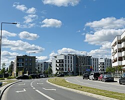 Street in Siekierki
 -
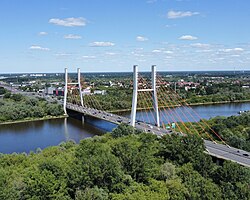 Siekierkowski Bridge
 -
-
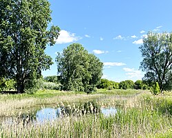
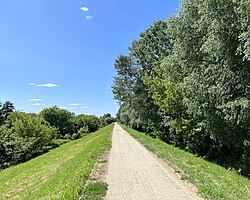 Floodbank by Vistula
 -
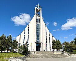 Catholic sanctuary of the Piarists
 -
 Memorial to the local World War II victims
 -
 Memorial of theFirst Polish Army crossing Vistula river during the Warsaw Uprising


References
- ^ Wejnert, Aleksander (1850). Opis historyczny trzech kęp na Wiśle pod Warszawą (Polkowska, Bełk, Saska) od najdawniejszych czasów do 1850 r. [Historical description of the three meadows by Vistula near Warsaw (Polkowska, Bełk, Saska) from old times until 1850] (in Polish). Drukarnia Banku Polskiego. pp. 18–24.
- ^ Encyklopedia Warszawy [Encyclopedia of Warsaw] (in Polish). Warsaw: Polskie Wydawnictwo Naukowe. 1975. p. 571.
- ^ a b c d e Korzenie Siekierek [Roots of Siekierki] (in Polish). Warsaw: Dom Kultury Dorożkarnia. 2017.
- ^ Słownik geograficzny Królestwa Polskiego, t. X: Rukszenice - Sochaczew [Geographical dictionary of the Kingdom of Poland, part 10: Rukszenice - Sochaczew] (in Polish). Warsaw. 1889.
{{cite book}}: CS1 maint: location missing publisher (link)> - ^ Nietyksza, Maria; Pruss, Witold (1973). Zmiany w układzie przestrzennym Warszawy. Wielkomiejski rozwój Warszawy do 1918 r. [Changes in the spatial layout of Warsaw. Urban development of Warsaw until 1918] (in Polish). Warsaw: Wydawnictwo Książka i Wiedza. p. 43.
- ^ Potrzuski, Kamil (2019). "Dzielnica olimpijska na warszawskich Siekierkach. Losy niezrealizowanego projektu w świetle akt nieruchomości miasta stołecznego Warszawy z lat 30. XX wieku" [The Olympic District in Warsaw's Siekierki. The fate of an unrealized project in light of the real estate records of the City of Warsaw in the 1930s]. Rozprawy Naukowe Akademii Wychowania Fizycznego we Wrocławiu (in Polish). 65. Wrocław: 16–34.
- OCLC 1003021533. Archived from the originalon 2018-12-09.
- ISBN 83-03-01684-9.
- ISBN 83-213-2993-4.
- ^ "Warszawski Obszar Chronionego Krajobrazu". warszawa.rdos.gov.pl (in Polish). Regionalna Dyrekcja Ochrony Środowiska w Warszawie.
- ^ Wojtczuk, Michał (2009-04-01). "Park technologiczny: Fatamorgana na łąkach" [Technology park: Fata Morgana on the meadows]. Gazeta Wyborcza (in Polish). Retrieved 2010-01-10.
- ^ Kraj, Izabela (2009-04-17). "Koniec marzeń PiS o Dolinie Krzemowej" [The end of Law and Justice's dreams of Silicon Valley]. Życie Warszawy (in Polish). Retrieved 2010-01-10.
- ^ "Nowa ulica na Mokotowie. Już w sobotę kierowcy pojadą "Czerniakowską bis"" [A new street in Mokotów. Starting this Saturday, drivers will travel on 'Czerniakowska bis'.]. metrowarszawa.gazeta.pl (in Polish). 2019-01-30. Retrieved 2019-02-04.
- ^ Urząd m.st. Warszawy (2023-02-13). "Stolica pięciu linii metra" [The capital of five metro lines]. um.warszawa.pl/ (in Polish). Retrieved 2023-02-13.
