
Siem Reap province
Siem Reap
សៀមរាប | |
|---|---|
| Siem Reap Province ខេត្តសៀមរាប | |
   .jpg) | |
 Seal | |
| Nickname: Gateway to Angkor | |
 Map of Cambodia highlighting Siem Reap | |
| Coordinates: 13°21′N 103°51′E / 13.350°N 103.850°E | |
| Country | |
| Settled | 802 |
| Provincial status | 23 December 1907[1] |
| Capital | Siem Reap |
| Subdivisions | 1 municipality; 13 districts |
| Government | |
| • Governor | Prak Sophoan (CPP) |
| • National Assembly | 6 / 125
|
| Area | |
| • Total | 10,299 km2 (3,976 sq mi) |
| • Rank | 10th |
| Population (2019)[2] | |
| • Total | |
| • Rank | 4th |
| • Density | 98/km2 (250/sq mi) |
| • Rank | 13th |
| Time zone | UTC+07:00 (ICT) |
| ISO 3166 code | KH-17 |
| Website | www |
Siem Reap, officially Siemreap
Siem Reap province is the tenth largest province in Cambodia. Having reached a population of one million in 2019, it ranks as the nation's fourth most populous province.
Etymology
The name Siem Reap literally means 'Siam defeated' and emerged after the victory of Ang Chan I over the Siamese in 1530 at Angkor, a reminder of the centuries-old conflict between the Siamese and the Khmer. In Siam, the province and its capital were called Siemmarat (Thai: เสียมราฐ), literally meaning 'Siam's territory'.[4]
The capital was again renamed "Siem Reap" (siam defeated) after it was rightfully returned to Cambodia in 1907 under the reign of Sisowath I (1904-1927) after military pressure on Siam by the joint forces of Cambodia and the French colonial government.
History
The province came under the control of the Thai kingdom of
Religion
The state religion is
Subdivisions
The province is divided into 1 municipality and 11 districts, and further subdivided into 100 communes and 907 villages.[6]
| ISO code |
Name | Khmer | Subdivisions | ||
|---|---|---|---|---|---|
| — Municipality —
| |||||
| 17-10 | Siem Reap
|
សៀមរាប | 12 sangkat | ||
| — District —
| |||||
| 17-01 | Angkor Chum | អង្គរជុំ | 7 khum | ||
| 17-02 | Angkor Thom
|
អង្គរធំ | 4 khum | ||
| 17-03 | Banteay Srei
|
បន្ទាយស្រី | 6 khum | ||
| 17-04 | Chi Kraeng | ជីក្រែង | 12 khum | ||
| 17-06 | Kralanh | ក្រឡាញ់ | 10 khum | ||
| 17-07 | Puok | ពួក | 14 khum | ||
| 17-09 | Prasat Bakong | ប្រាសាទបាគង | 9 khum | ||
| 17-11 | Soutr Nikom | សូត្រនិគម | 10 khum | ||
| 17-12 | Srei Snam | ស្រីស្នម | 6 khum | ||
| 17-13 | Svay Leu | ស្វាយលើ | 5 khum | ||
| 17-14 | Varin
|
វ៉ារិន | 5 khum | ||
Gallery
-

-
 Angkor Wat view from Phnom Bakheng
 -
 South gate of Angkor Thom
 -
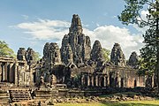 Bayon Temple
 -


References
- ^ "History of Siem Reap". siemreap.gov.kh. Archived from the original on 18 July 2019. Retrieved 17 August 2019.
- ^ a b "General Population Census of the Kingdom of Cambodia 2019 – Final Results" (PDF). National Institute of Statistics. Ministry of Planning. 26 January 2021. Retrieved 3 February 2021.
- ^ "Geographical Names of the Kingdom of Cambodia" (PDF). UNSTATS. Eighth United Nations Conference on the Standardization of Geographical Names. 29 August 2002. Retrieved 7 June 2019.
- ^ Article 6 of the "Convention between France and Siam Amending the Stipulations of the Treaty of 8 October 1904, Concerning the Territories and the Other Arrangements, Signed at Paris, the 13th February 1904."
- ^ "General Population census of the Kingdom of Cambodia 2019" (PDF). National Institute of Statistics Ministry of planning. October 2020.
- ^ "Administration; Siem Reap". Kingdom of Cambodia. Archived from the original on 27 May 2009. Retrieved 27 June 2010.
External links
- Official website
- Siem Reap - The Gate to Angkor (Official Website of the Provincial Town Siem Reap on www.rithyrineangkorresidence.com
Places adjacent to Siem Reap province | |
|---|---|
Capital city: Siem Reap | ||
| Districts |
| |
| Geography | ||
| Angkor Sites | ||
| Autonomous municipality | ||
|---|---|---|
| Provinces | ||
| Authority control databases: National |
|---|