
Sierra Nevada (Spain)
| Sierra Nevada | |
|---|---|
.jpg) View of the Sierra Nevada | |
| Highest point | |
| Peak | Mulhacén |
| Elevation | 3,479 m (11,414 ft) |
| Coordinates | 37°3′12″N 3°18′41″W / 37.05333°N 3.31139°W |
| Geography | |
 Sierra Nevada Location in Spain | |
| Location | Alpine |
Sierra Nevada (Spanish:
It is a popular tourist destination, as its high peaks make skiing possible in one of Europe's most southerly ski resorts, in an area along the Mediterranean Sea predominantly known for its high temperatures and abundant sunshine. At its foothills is found the city of Granada, and a little further south, Almería and Motril.
Parts of the range have been included in the
Formation
The Sierra Nevada was formed during the
Geography

Central to the mountain range is a ridge running broadly west-south-west - east-north-east. For a substantial distance, the watershed stays consistently above 3,000 metres (9,800 ft). This is sufficient altitude for the peaks to be consistently snow-covered.[1]
On the southern side of the range, several long, narrow river valleys lead off towards the south-west, separated by a number of subsidiary ridges. On the steeper and craggier northern side, the valleys have less regular orientations. This side is dominated by the
Geologically, the range is composed chiefly of soft micaceous schists, sloping steeply to the north, but more gradually to the south and south-east.[1]
Highest peaks
| Highest peaks of Sierra Nevada | ||
| Peak (> 3,000m) | Height (m) | |
| Mulhacén | 3,479 | |
| Veleta | 3,398 | |
| Alcazaba | 3,371 | |
| Cerro los Machos | 3,324 | |
| Puntal de Siete Lagunas | 3,248 | |
| Puntal de la Caldera | 3,226 | |
| Pico de Elorrieta | 3,206 | |
| Crestones Río Seco | 3,198 | |
| Loma Pelada | 3,187 | |
| Cerro Pelado | 3,179 | |
| Tajos de la Virgen | 3,160 | |
| Tosal del Cartujo | 3,152 | |
| Pico de La Atalaya | 3,148 | |
| Puntal de Vacares | 3,143 | |
| Cerro Rasero | 3,139 | |
| Tajos del Nevero | 3,120 | |
| Raspones Río Seco | 3,120 | |
| Tajos Altos | 3,111 | |
| Picón de Jeres | 3,090 | |
| Tajo de los Machos | 3,088 | |
| Cerrillo Redondo | 3,058 | |
| Juego de Bolos | 3,018 | |
| Pico del Caballo | 3,011 | |
Climate
According to the Köppen climate classification, Sierra Nevada has a Mediterranean climate, with different variations depending on the altitude. Above 2,500 metres (8,200 ft) the climate is Mediterranean-influenced subarctic (Dsc), due to the location's high elevation and low summer precipitation. With June and September being around the threshold of 10 °C (50 °F) in mean temperature to avoid the subarctic classification, the climate at a slightly lower elevation is continental highland climate. At an elevation slightly lower than that classification area; where February means average above −3 °C (27 °F); it falls into the normal cool-summer mediterranean classification transitioning with the hot-summer variety in surrounding lowland areas. This renders Sierra Nevada's climate a highland cooled-down variety of a typical mediterranean climate. Summer and winter daytime temperatures are some 12 °C lower than found in Granada, differences that are even greater in spring as Sierra Nevada takes longer to approach the short summers. In May daytime highs in Sierra Nevada are around 4 °C (39 °F) with Granada having an average of 24 °C (75 °F). The yearly temperature of 3.9 °C (39.0 °F) at the ski station of Pradollano is in stark contrast to Granada's 15.7 °C (60.3 °F) and coastal Málaga's 18.5 °C (65.3 °F).[2][3]
| Climate data for Pradollano Ski Station (1975–1989); 2,507 m (8,225 ft) | |||||||||||||
|---|---|---|---|---|---|---|---|---|---|---|---|---|---|
| Month | Jan | Feb | Mar | Apr | May | Jun | Jul | Aug | Sep | Oct | Nov | Dec | Year |
| Mean daily maximum °C (°F) | 0.3 (32.5) |
−0.9 (30.4) |
0.6 (33.1) |
3.2 (37.8) |
4.6 (40.3) |
14.9 (58.8) |
21.6 (70.9) |
19.8 (67.6) |
14.2 (57.6) |
10.4 (50.7) |
3.5 (38.3) |
2.6 (36.7) |
7.8 (46.0) |
| Daily mean °C (°F) | −2.9 (26.8) |
−4.4 (24.1) |
−3.4 (25.9) |
−0.6 (30.9) |
0.9 (33.6) |
9.9 (49.8) |
16.6 (61.9) |
15.2 (59.4) |
9.9 (49.8) |
6.3 (43.3) |
0.1 (32.2) |
−0.7 (30.7) |
3.9 (39.0) |
| Mean daily minimum °C (°F) | −6.1 (21.0) |
−7.9 (17.8) |
−7.5 (18.5) |
−4.3 (24.3) |
−2.9 (26.8) |
5.6 (42.1) |
11.9 (53.4) |
10.6 (51.1) |
5.7 (42.3) |
2.2 (36.0) |
−3.3 (26.1) |
−4.0 (24.8) |
0.0 (32.0) |
| Average precipitation mm (inches) | 86.7 (3.41) |
91.2 (3.59) |
78.8 (3.10) |
53.8 (2.12) |
53.6 (2.11) |
29.7 (1.17) |
6.1 (0.24) |
11.7 (0.46) |
33.7 (1.33) |
69.0 (2.72) |
85.2 (3.35) |
93.1 (3.67) |
692.0 (27.24) |
| Source 1: Phytosociological Research Center[4] | |||||||||||||
| Source 2: Worldwide Bioclimatic Classification System (Complutense University of Madrid)[5] | |||||||||||||
Sport
Gallery
-
 Sierra Nevada - view from Granada city
 -

-
 Landscape south of Pitres
 -
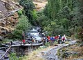 Stone bridge over Rio Poqueira, Sierra Nevada
 -

-
-

.jpg)


.jpg)
See also
Notes
- ^ The highest peak in Spanish territory is Teide on the island of Tenerife in the Canary Islands, which is politically Spanish but geographically part of Africa.
References
- ^ a b Chisholm, Hugh, ed. (1911). . Encyclopædia Britannica. Vol. 25 (11th ed.). Cambridge University Press. p. 57.
- ^ "Standard climate values for Granada". Aemet.es. Archived from the original on 8 December 2015. Retrieved 5 December 2015.
- ^ "Standard climate values for Málaga". Aemet.es. Archived from the original on 4 July 2015. Retrieved 5 December 2015.
- ^ "Datos climátológicos de Sierra Nevada" (in Spanish). Phytosociological Research Center. Archived from the original on 2012-10-10. Retrieved 2011-07-02.
- ^ "Diagramas Climáticos de Pradollano" (in Spanish). S.Rivas-Martínez, Centro de Investigaciones Fitosociológicas, Madrid. 23 June 2020. Archived from the original on 26 June 2020. Retrieved 23 June 2020.
Bibliography
- Francisco Pérez Raya, Joaquín Molero Mesa, Francisco Valle Tendero, 1992: "Parque Natural de Sierra Nevada. Paisaje, fauna, flora, itinerarios". Ed. Rueda. Madrid. ISBN 84-7207-067-0(Spanish)
- "Flora de la Tundra de Sierra Nevada". Pablo Prieto Fernández, Ed. Universidad de Granada. ISBN 84-600-1810-5(Spanish)
- "Sierra Nevada: Guía de Montaña". Aurelio del Castillo y Antonio del Castillo. Ed. Penibética, 2003. ISBN 84-932022-3-1(Spanish)
Further reading
- "Sierra Nevada, Spain". NASA Earth Observatory. Archived from the original on 1 October 2006. Retrieved 28 April 2006.
External links
![]() Media related to Sierra Nevada (Spain) at Wikimedia Commons
Media related to Sierra Nevada (Spain) at Wikimedia Commons
- Google Maps - Satellite Photo
- (in Spanish) Sierra Nevada Ski Resort - official site
- Sierra Nevada ski resort - trail map
- Maps of the Sierra Nevada
- nevasport.com - XVII sport week - Old Pictures
- (in Spanish) Natural Park Sierra Nevada
- (in Spanish) Sulayr
| Authority control databases: National |
|---|