
Silurian
| Silurian | |
|---|---|
Period | |
| Stratigraphic unit | System |
| First proposed by | Roderick Murchison, 1835 |
| Time span formality | Formal |
| Lower boundary definition | FAD of the Graptolite Akidograptus ascensus |
| Lower boundary GSSP | Dob's Linn, Moffat, United Kingdom 55°26′24″N 3°16′12″W / 55.4400°N 3.2700°W |
| Lower GSSP ratified | 1984[4][5] |
| Upper boundary definition | FAD of the Graptolite Monograptus uniformis |
| Upper boundary GSSP | Klonk, Czech Republic 49°51′18″N 13°47′31″E / 49.8550°N 13.7920°E |
| Upper GSSP ratified | 1972[6] |
| Atmospheric and climatic data | |
| Sea level above present day | Around 180 m, with short-term negative excursions[7] |
The Silurian (
One important event in this period was the initial establishment of terrestrial life in what is known as the
Another significant evolutionary milestone during the Silurian was the diversification of
History of study
million years ago) |
The Silurian system was first identified by the Scottish geologist Roderick Murchison, who was examining fossil-bearing sedimentary rock strata in south Wales in the early 1830s. He named the sequences for a Celtic tribe of Wales, the Silures, inspired by his friend Adam Sedgwick, who had named the period of his study the Cambrian, from the Latin name for Wales.[17] This naming does not indicate any correlation between the occurrence of the Silurian rocks and the land inhabited by the Silures (cf. Geologic map of Wales, Map of pre-Roman tribes of Wales). In 1835 the two men presented a joint paper, under the title On the Silurian and Cambrian Systems, Exhibiting the Order in which the Older Sedimentary Strata Succeed each other in England and Wales, which was the germ of the modern geological time scale.[18] As it was first identified, the "Silurian" series when traced farther afield quickly came to overlap Sedgwick's "Cambrian" sequence, however, provoking furious disagreements that ended the friendship.
The English geologist Charles Lapworth resolved the conflict by defining a new Ordovician system including the contested beds.[19] An alternative name for the Silurian was "Gotlandian" after the strata of the Baltic island of Gotland.[20]
The French geologist Joachim Barrande, building on Murchison's work, used the term Silurian in a more comprehensive sense than was justified by subsequent knowledge. He divided the Silurian rocks of Bohemia into eight stages.[21] His interpretation was questioned in 1854 by Edward Forbes,[22] and the later stages of Barrande; F, G and H have since been shown to be Devonian. Despite these modifications in the original groupings of the strata, it is recognized that Barrande established Bohemia as a classic ground for the study of the earliest Silurian fossils.
Subdivisions
| Epoch | Age |
Start (mya) |
Etymology of Epochs and Stages |
Notes |
|---|---|---|---|---|
| Llandovery | Rhuddanian | 443.8 | Cefn-Rhuddan Farm, Llandovery in Carmarthenshire, Wales | |
| Aeronian | 440.8 | Cwm Coed-Aeron Farm, Wales | Trefawr Track near the farm is the site of the GSSP | |
| Telychian | 438.5 | Pen-lan-Telych Farm, Llandovery, Wales | ||
Wenlock |
Sheinwoodian | 433.4 | Sheinwood village, Much Wenlock and Wenlock Edge, Shropshire, England | During the Wenlock, the oldest-known |
| Homerian | 430.5 | Homer, Shropshire, England | ||
| Ludlow | Gorstian | 427.4 | Gorsty village near Ludlow, Shropshire, England | |
| Ludfordian | 425.6 | Ludford, Shropshire, England | ||
Přídolí |
— | 423.0 | Named after a locality at the Homolka a Přídolí nature reserve near the Prague suburb of Slivenec, Czech Republic. | Přídolí is the old name of a cadastral field area.[24] |
Paleogeography

With the supercontinent Gondwana covering the equator and much of the southern hemisphere, a large ocean occupied most of the northern half of the globe.[25] The high sea levels of the Silurian and the relatively flat land (with few significant mountain belts) resulted in a number of island chains, and thus a rich diversity of environmental settings.[25]
During the Silurian, Gondwana continued a slow southward drift to high southern latitudes, but there is evidence that the Silurian icecaps were less extensive than those of the late-Ordovician glaciation. The southern continents remained united during this period. The melting of icecaps and
When the proto-Europe collided with North America, the collision folded coastal sediments that had been accumulating since the Cambrian off the east coast of North America and the west coast of Europe. This event is the Caledonian orogeny, a spate of mountain building that stretched from New York State through conjoined Europe and Greenland to Norway. At the end of the Silurian, sea levels dropped again, leaving telltale basins of evaporites extending from Michigan to West Virginia, and the new mountain ranges were rapidly eroded. The Teays River, flowing into the shallow mid-continental sea, eroded Ordovician Period strata, forming deposits of Silurian strata in northern Ohio and Indiana.
The vast ocean of Panthalassa covered most of the northern hemisphere. Other minor oceans include two phases of the Tethys, the Proto-Tethys and Paleo-Tethys, the Rheic Ocean, the Iapetus Ocean (a narrow seaway between Avalonia and Laurentia), and the newly formed Ural Ocean.

Climate and sea level
The Silurian period was once believed to have enjoyed relatively stable and warm temperatures, in contrast with the extreme glaciations of the Ordovician before it and the extreme heat of the ensuing Devonian; however, it is now known that the global climate underwent many drastic fluctuations throughout the Silurian,[26][27] evidenced by numerous major carbon and oxygen isotope excursions during this geologic period.[28][29][30] Sea levels rose from their Hirnantian low throughout the first half of the Silurian; they subsequently fell throughout the rest of the period, although smaller scale patterns are superimposed on this general trend; fifteen high-stands (periods when sea levels were above the edge of the continental shelf) can be identified, and the highest Silurian sea level was probably around 140 metres (459 ft) higher than the lowest level reached.[25]
During this period, the Earth entered a warm greenhouse phase, supported by high CO2 levels of 4500 ppm, and warm shallow seas covered much of the equatorial land masses.[31] Early in the Silurian, glaciers retreated back into the South Pole until they almost disappeared in the middle of Silurian.[27] Layers of broken shells (called coquina) provide strong evidence of a climate dominated by violent storms generated then as now by warm sea surfaces.[32]
Perturbations
The climate and
Flora and fauna
The Silurian period has been viewed by some palaeontologists as an extended recovery interval following the Late Ordovician mass extinction (LOME), which interrupted the cascading increase in biodiversity that had continuously gone on throughout the Cambrian and most of the Ordovician.[35]
The Silurian was the first period to see megafossils of extensive terrestrial biota in the form of
The first fossil records of vascular plants, that is, land plants with tissues that carry water and food, appeared in the second half of the Silurian Period.[37] The earliest-known representatives of this group are Cooksonia. Most of the sediments containing Cooksonia are marine in nature. Preferred habitats were likely along rivers and streams. Baragwanathia appears to be almost as old, dating to the early Ludlow (420 million years) and has branching stems and needle-like leaves of 10–20 centimetres (3.9–7.9 in). The plant shows a high degree of development in relation to the age of its fossil remains. Fossils of this plant have been recorded in Australia,[38][39] Canada,[40] and China.[41] Eohostimella heathana is an early, probably terrestrial, "plant" known from compression fossils[42] of Early Silurian (Llandovery) age.[43] The chemistry of its fossils is similar to that of fossilised vascular plants, rather than algae.[42]
Fossils that are considered as terrestrial animals are also known from the Silurian. The definitive oldest record of
The first bony fish, the
-
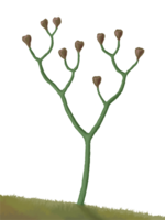 Cooksonia, the earliest vascular plant, middle Silurian
 -
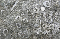
 Silurian sea bed fossils collected from Wren's Nest Nature Reserve, Dudley UK
 -
-
 Silurian sea bed fossils collected from Wren's Nest Nature Reserve, Dudley UK
 -
 Eurypterus, a common Upper Silurian eurypterid
 -
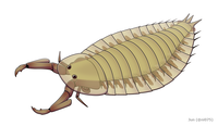
 Pterygotus was a giant eurypterid that had a nearly cosmopolitan distribution (reconstruction shown here is Devonian species P. anglicus)
 -
 Trilobites were still diverse and common in the Silurian. Fossils of Calymene celebra are extremely abundant in parts of central US.
 -
 Halysites was a Tabulate coral, an extinct group that lived through the Paleozoic
 -
 Parioscorpio was an enigmatic arthropod from the Silurian of Wisconsin
 -
 ADalmanites limulurus specimen from Silurian strata of New York
 -
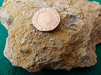
 A rock containing several geodized pentamerid brachiopods from strata in Indiana
 -

-

-
-
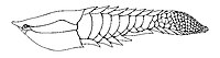
 galeaspid agnathan from the early Silurian (Telychian) of China, showing origin of paired fins
 -

-
 Fanjingshania, climatiid spiny sharkfrom the lower Silurian (Aeronian) described from disarticulated dermoskeletal elements
 -
![Shenacanthus vermiformis[69] is jawed stem-chondrichthyan genus from the early Silurian (Telychian) of China](//upload.wikimedia.org/wikipedia/commons/thumb/6/6c/Shenacanthus_vermiformis.jpg/154px-Shenacanthus_vermiformis.jpg) Shenacanthus[78] is jawed stem-chondrichthyan genus from the early Silurian (Telychian) of China
Shenacanthus[78] is jawed stem-chondrichthyan genus from the early Silurian (Telychian) of China -
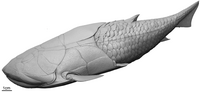
![Xiushanosteus[78] is the oldest known placoderm from the early Silurian (Telychian) of China](//upload.wikimedia.org/wikipedia/commons/thumb/c/c5/Xiushanosteus.jpg/200px-Xiushanosteus.jpg) Xiushanosteus[78] is the oldest known placoderm from the early Silurian (Telychian) of China
Xiushanosteus[78] is the oldest known placoderm from the early Silurian (Telychian) of China -
 Placodermfish from the late Silurian


_1.jpg)


![Shenacanthus vermiformis[69] is jawed stem-chondrichthyan genus from the early Silurian (Telychian) of China](/File:Shenacanthus_vermiformis.jpg)
![Xiushanosteus[78] is the oldest known placoderm from the early Silurian (Telychian) of China](/File:Xiushanosteus.jpg)

Notes
- .
- .
- ^ "Chart/Time Scale". www.stratigraphy.org. International Commission on Stratigraphy.
- .
- . Retrieved 11 December 2020.
- ^ Chlupáč, Ivo; Hladil, Jindrich (January 2000). "The global stratotype section and point of the Silurian-Devonian boundary". CFS Courier Forschungsinstitut Senckenberg. Retrieved 7 December 2020.
- S2CID 206514545.
- ISBN 978-1-4058-8118-0.
- ^ "Silurian". Dictionary.com Unabridged (Online). n.d.
- CollinsDictionary.com. HarperCollins.
- ^ "International Chronostratigraphic Chart v.2015/01" (PDF). International Commission on Stratigraphy. January 2015.
- ^ S2CID 249616013.
- ^ . Retrieved 8 December 2022.
- S2CID 56645104.
- .
- PMID 25903631.
- ^ See:
- Murchison, Roderick Impey (1835). "On the Silurian system of rocks". Philosophical Magazine. 3rd series. 7 (37): 46–52. . From p. 48: " … I venture to suggest, that as the great mass of rocks in question, trending from south-west to north-east, traverses the kingdom of our ancestors the Silures, the term "Silurian system" should be adopted … "
- Wilmarth, Mary Grace (1925). Bulletin 769: The Geologic Time Classification of the United States Geological Survey Compared With Other Classifications, accompanied by the original definitions of era, period and epoch terms. Washington, D.C., U.S.: U.S. Government Printing Office. p. 80.
- ^ Sedgwick; Murchison, R.I. (1835). "On the Silurian and Cambrian systems, exhibiting the order in which the older sedimentary strata succeed each other in England and Wales". Report of the Fifth Meeting of the British Association for the Advancement of Science. § Notices and Abstracts of Miscellaneous Communications to the Sections. 5: 59–61.
- S2CID 129165105. From pp. 13–14: "North Wales itself – at all events the whole of the great Bala district where Sedgwick first worked out the physical succession among the rocks of the intermediate or so-called Upper Cambrian or Lower Silurian system; and in all probability much of the Shelve and the Caradoc area, whence Murchison first published its distinctive fossils – lay within the territory of the Ordovices; … Here, then, have we the hint for the appropriate title for the central system of the Lower Palaeozoics. It should be called the Ordovician System, after this old British tribe."
- Albert Auguste Cochon de Lapparent (1839–1908): Lapparent, A. de (1893). Traité de Géologie(in French). Vol. 2 (3rd ed.). Paris, France: F. Savy. p. 748. From p. 748: "D'accord avec ces divisions, on distingue communément dans le silurien trois étages: l'étage inférieur ou cambrien (1); l'étage moyen ou ordovicien (2); l'étage supérieur ou gothlandien (3)." (In agreement with these divisions, one generally distinguishes, within the Silurian, three stages: the lower stage or Cambrian [1]; the middle stage or Ordovician [2]; the upper stage or Gotlandian [3].)
- ^ Barrande, Joachim (1852). Systême silurien du centre de la Bohême (in French). Paris, France and Prague, (Czech Republic): (Self-published). pp. ix–x.
- ^ Forbes, Edward (1854). "Anniversary Address of the President". Quarterly Journal of the Geological Society of London. 10: xxii–lxxxi. See p. xxxiv.
- ^ a b Paul Selden & Helen Read (2008). "The oldest land animals: Silurian millipedes from Scotland" (PDF). Bulletin of the British Myriapod & Isopod Group. 23: 36–37.
- .
- ^ .
- S2CID 252504361. Retrieved 8 December 2022.
- ^ S2CID 135118794.
- S2CID 218930512.
- S2CID 213445668. Retrieved 8 December 2022.
- ^ .
- ISBN 9780125986557.
- .
- S2CID 130640332.
- ISBN 978-3-540-75915-7.
- PMID 30910963.
- S2CID 246320087. Retrieved 23 November 2022.
- ISBN 9781438109992.
- S2CID 131287538. Retrieved 8 December 2022.
- .
- .
- ^ Bora, Lily (2010). Principles of Paleobotany. Mittal Publications. pp. 36–37.
- ^ S2CID 21794174.
- ISBN 978-0-231-11161-4, p. 4
- ^ S2CID 238220137.
- ISSN 0031-0239.
- ^ Shear, William A.; Jeram, Andrew J.; Selden, Paul (1998). Centiped legs (Arthropoda, Chilopoda, Scutigeromorpha) from the Silurian and Devonian of Britain and the Devonian of North America. New York, NY: American Museum of Natural History.
- PMID 17810866.
- ISBN 978-0-226-04155-1.
- S2CID 131201588.
- PMID 28658320.
- ISSN 0016-7649.
- . Retrieved 16 April 2023.
- S2CID 129323463. Retrieved 16 April 2023.
- . Retrieved 16 April 2023.
- ^ . Retrieved 23 November 2022.
- . Retrieved 16 April 2023.
- doi:10.1666/0094-8373(2003)0292.0.CO;2 (inactive 31 January 2024). Retrieved 16 April 2023.)
{{cite journal}}: CS1 maint: DOI inactive as of January 2024 (link - PMID 36114227.
- S2CID 233820331.
- . Retrieved 16 April 2023.
- S2CID 149500698. Retrieved 16 April 2023.
- . Retrieved 16 April 2023.
- ^ S2CID 251122025. Retrieved 16 April 2023.
- . Retrieved 16 April 2023.
- . Retrieved 16 April 2023.
- . Retrieved 16 April 2023.
- . Retrieved 16 April 2023.
- doi:10.1666/0094-8373(2000)0262.0.CO;2 (inactive 31 January 2024). Retrieved 16 April 2023.)
{{cite journal}}: CS1 maint: DOI inactive as of January 2024 (link - S2CID 67838459. Retrieved 16 April 2023.
- S2CID 134049045.
- . Retrieved 16 April 2023.
- S2CID 224964119. Retrieved 16 April 2023.
- . Retrieved 2014-06-11.
- S2CID 131651974. Retrieved 2014-06-11.
- S2CID 224869051. Retrieved 16 April 2023.
- PMID 24307674.
- S2CID 252569771.
- ^ S2CID 252569910.
References
- ISBN 0-521-40949-7)
- Mikulic, DG, DEG Briggs, and J Kluessendorf. 1985. A new exceptionally preserved biota from the Lower Silurian of Wisconsin, USA. Philosophical Transactions of the Royal Society of London, 311B:75-86.
- Moore, RA; Briggs, DEG; Braddy, SJ; Anderson, LI; Mikulic, DG; Kluessendorf, J (2005). "A new synziphosurine (Chelicerata: Xiphosura) from the Late Llandovery (Silurian) Waukesha Lagerstatte, Wisconsin, USA". Journal of Paleontology. 79 (2): 242–250. S2CID 56570105.
External links
- Ogg, Jim (June 2004), Overview of Global Boundary Stratotype Sections and Points (GSSP's)
- Palaeos: Silurian
- UCMP Berkeley: The Silurian
- Paleoportal: Silurian strata in U.S., state by state
- USGS:Silurian and Devonian Rocks (U.S.)
- "International Commission on Stratigraphy (ICS)". Geologic Time Scale 2004. Retrieved September 19, 2005.
- Examples of Silurian Fossils
- GeoWhen Database for the Silurian
- Silurian (Chronostratography scale)