
Sinsheim
Sinsheim | |
|---|---|
Panoramic view | |
 Coat of arms | |
Location of Sinsheim within Rhein-Neckar-Kreis district 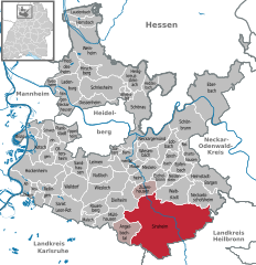 | |
 Sinsheim  Sinsheim | |
| Coordinates: 49°15′N 08°53′E / 49.250°N 8.883°E | |
| Country | Germany |
| State | Baden-Württemberg |
| Admin. region | Karlsruhe |
| District | Rhein-Neckar-Kreis |
| Government | |
| • Lord mayor (2020–28) | Jörg Albrecht[1] (Ind.) |
| Area | |
| • Total | 127.01 km2 (49.04 sq mi) |
| Elevation | 154 m (505 ft) |
| Population (2021-12-31)[2] | |
| • Total | 35,707 |
| • Density | 280/km2 (730/sq mi) |
| Time zone | UTC+01:00 (CET) |
| • Summer (DST) | UTC+02:00 (CEST) |
| Postal codes | 74871-74889 |
| Dialling codes | 07260, 07261, 07265, 07266, 07268 |
| Vehicle registration | HD |
| Website | www |


Sinsheim (German pronunciation:
Geography
Overview
Sinsheim consists of a town centre and 12 suburbs with a total population of 35,373 (as of December 2011). Its area encompasses 127 square kilometers (49 sq mi). The
Subdivisions
The list below shows the 12 suburban villages (Stadtteile).[3] Population data was as of 31 December 2020 and the one of Sinsheim (the town proper) was of 12,914.[4]
|
|
History
The region around Sinsheim has been settled since 700,000 BC, as shown by the finding of the fossil Homo heidelbergensis in the village of Mauer, about 12 km (7 miles) north of Sinsheim. The Romans ruled the area from 90 AD to 260 AD. The city was possibly founded in about 550 AD by the Frankish nobleman Sunno. It was first historically mentioned in 770 AD in the Codex of the cloister Lorsch. Since 1192, the town had city rights, a privilege first granted by Henry IV, Holy Roman Emperor.
Sinsheim was affected by wars and poverty from the 1500s to the 1700s. Sinsheim-born revolutionary Franz Sigel became a famous Union general in the American Civil War.
The
Demographics
The numbers are estimates, census results(¹) or official data of the statistical offices (only primary residences).
|
|
¹ census results
Main sights

Sinsheim's main tourist attraction is the
Additionally, Sinsheim has a medieval city core; the Altes Rathaus (old Town Hall) is a museum for the town and its role in the
Sport

Stadium
On September 19, 2006, the mayor of Sinsheim announced a stadium would be built not far from the
Twin towns – sister cities
 Barcs, Hungary
 Longué-Jumelles, France
Notable people
- Hans Seyffer (c.1460–1509), stone sculptor and wood carver
- Franz Sigel (1824–1902), U.S. Army General in the American Civil War
- Walter Horn (1908–1995), German-American medievalist scholar
- Volker Kauder (born 1949), politician
- Christian Eichner (born 1982), football player and manager
- Sarai Linder (born 1999), football player for the Germany women's national football team
References
- ^ Aktuelle Wahlergebnisse, Staatsanzeiger, accessed 14 September 2021.
- Statistisches Landesamt Baden-Württemberg. June 2022.
- ^ (in German) Stadtteile: Stadt Sinsheim (municipal website)
- ^ (in German) Bevölkerungsstatistik der Stadt Sinsheim (Population statistics of Sinsheim)
- ^ "Partnerstädte". sinsheim.de (in German). Sinsheim. Retrieved 2021-03-09.
External links
![]() Media related to Sinsheim at Wikimedia Commons
Media related to Sinsheim at Wikimedia Commons

| International | |
|---|---|
| National | |
| Geographic | |