
Sistema Ibérico
| Iberian System | |
|---|---|
| Sistema Ibérico | |
Moncayo | |
| Elevation | 2,313 m (7,589 ft) |
| Coordinates | 41°44′45″N 01°46′53″W / 41.74583°N 1.78139°W |
| Geography | |
 Location of the Sistema Ibérico in the Iberian Peninsula
| |
| Country | Castile-La Mancha |
| Geology | |
| Orogeny | Alpine |
| Age of rock | Tertiary |
| Type of rock | Nummulite limestone, marble and sandstone |


The Iberian System (Spanish: Sistema Ibérico, pronounced [sisˈtemajˈβeɾiko]) is one of the major systems of mountain ranges in Spain. It consists of a vast and complex area of mostly relatively high and rugged mountain chains and massifs located in the central region of the
The system is
to the west and south.There are important mining areas in some of the ranges such as Sierra Menera, Sierra de Arcos and Sierra de San Just, making the system one of the chief mining regions in Spain since ancient times.[1][2] One of the comarcas of Aragon located in the Iberian System was given the name of Cuencas Mineras, lit. 'Mining Basins', since mining is the main activity in the comarca.[3]
Location and description
The Sistema Ibérico mountain range borders the
This system runs northwest-southeast between the Ebro plain and the Meseta Central for over 500 km, from the
The geology of the Iberian System is complex, for it can hardly be defined as a homogeneous system. It is composed of a haphazard and motley series of mountain ranges, massifs, plateaus and depressions without a definite common petrologic composition and overall structure. Nummulite limestone, marble and sandstone are common throughout the area. Some of the parts of the system stand geologically isolated, interrupting the continuity of the whole, linked to the other parts through high plateaus of varying altitudes.[4]
Ecology and human activity
Population decline
Large zones of the mountainous Iberian System have undergone heavy
The exodus from the rural mountainous areas in Spain rose after
Fauna
The heavy depopulation has favored wildlife so that one of the last colonies of
The most common
Some
Traditional
Vegetation
Some ranges have forested patches, consisting mainly of
Other ranges are rocky and quite bare with
Centaurea pinnata is an endangered species of plant present in the Sierra de Vicort and Sierra de Santa Cruz mountain ranges.[12]
Mountain ranges
The Sistema Ibérico comprises several mountain ranges and massifs:
- Northern: Moncayo Massif in the north, always crested with snow in the winter, with its eastern prolongation the Sierra de Nava Alta.
- Western: Smaller and drier mountain ranges close to the transition area with the Sistema Central, such as Sierra de Perdices, Sierra Ministra, Sierra de Caldereros (Águila 1,443 m), Sierra de Pardos, Sierra de Miñana, Sierra de Solorio, Sierra de Selas (Aragoncillo 1,517 m) and Parameras de Molina (Mojón Alto 1,408 m).
- Central: Numerous mountain ranges located at the heart of the system, such as Sierra de Santa Cruz, Sierra de Cucalón, Sierra de Herrera, Sierra de San Just, Sierra de Lidón and Sierra Palomera, among others.
- Southwestern: Serranía de Cuenca, Sierra Menera, Sierra de Albarracín, Montes de Picaza (Colmenarejo 1,426 m), Montes Universales and Sierra de Mira.
- Southeastern: .
- Eastern: A succession of ranges that reaches the Mediterranean Sea, including the Serra de la Vall d'Àngel, the Cervera Mountains, Serra de Sant Pere, Serra Calderona and Serra d'Espadàfoothills at the eastern end.
- Northeastern: A complex mountainous area connecting with the Catalan Pre-Coastal Range, which includes the Ports de Tortosa-Beseit[13][14] and the Benifassà Mountains.
Main subranges and features
-
 The aridSierra de los Caballos range rises behind Molinos
 -
 The main peaks of theCueva de Agreda
 -
 Sierra del Bollón, foothills of the Moncayo Massif, near Fuendejalón
 -
-
 The massivePorts de Beseit
 -
 Sierra Mayabona
 -
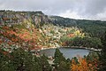 The Laguna Negra in the Picos de Urbión area
 -
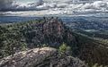
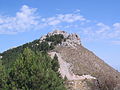
 Sierra de San Just above Ejulve
 -
 Waterfall in the Monasterio de Piedra Natural Park
 -
 Sierra de Algairén towering behind Almonacid de la Sierra
 -
 Rugged Sierra de Albarracín
 -
 Black pine trees near Valdelinares, Sierra de Gúdar
 -
 La Modorra, highest peak in the Sierra de Cucalón system
 -
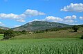
 Sierra de la Virgen behind Gotor
 -
 View of Morella
 -
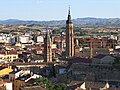 Calatayud with the Sierra de Vicort in the background
 -
 Purujosa from the Cabezo
 -
-
 The Penyagolosa summit
 -
 Sierra de Alcarama in La Rioja
 -
 "Pico Palomera", part of the central-uplift chain in the Rubielos de la Cérida impact structure in Sierra Palomera
 -
 Cabezo del Santo, Sierra de Castejón, Brieva de Cameros, La Rioja
 -
 Los Callejones de Las Majadas in the Serranía de Cuenca
 -
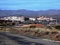
 View of Calmarza with the Sierra de Solorio cliffs above the town
 -
 Soria Province
 -
 Ranera Peak in Sierra de Mira
 -
 Northeastern end of Sierra Carrascosa with the "Guerrero Romano" rock formation
 -
 Monegre peak in Sierra de Nava Alta
 -
 South face of Isasa Peak, Sierra de Peñalmonte
 -
 Laguna de Gallocanta, located in an endorheic basin within the Iberian System
 -
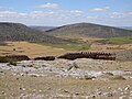
 Hill in the Sierra de Arcos area with unusual rock formations on top
 -
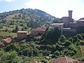
 Vistabella de Huerva below Sierra de Herrerarange
 -
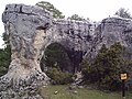
 Paridera cave, in the Piedra river, next to Monasterio de Piedra, Spain
 -
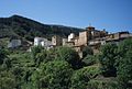
 Montenegro de Cameros, typical village in the northern part of the range


Peaks
The main peaks of the system are:
Rivers
The Sistema Ibérico is not as high as other mountain systems in Spain. It is, however, very significant from the hydrographic point of view for important rivers of the Iberian Peninsula have their source in its mountains, which divide the Atlantic from the Mediterranean watershed. The following rivers rise in the Sistema Ibérico:
- The Douro and the Tagus, flowing westwards across the Meseta Central towards Portugal
- The Jalón River, one of the main tributaries of the Ebro, flowing northwards, as well as the Huerva and the Aranda River
- The Turia, the Júcar and the Cabriel flowing eastwards across the Valencian Community towards the Mediterranean Sea
See also
- List of mountains in Aragon
- List of mountains in the Valencian Community
- List of mountains in Catalonia
- Monasterio de Piedra
- Laguna de Gallocanta
- Forests of the Iberian Peninsula
References
- ^ "Recursos minerales de España - Universidad de Zaragoza". Archived from the original on 2011-08-10. Retrieved 2011-06-05.
- ^ Luis Diego Arribas, Contemporary Art and Opencast Mining, University of Zaragoza, 2009
- ^ Comarcas de Aragón - Cuencas Mineras
- ^ Natura Xilocae - Entre la sierra de Caldereros y el Maestrazgo de Teruel
- ^ Pueblos deshabitados - Collado de la Grulla (Teruel)
- ^ Un pueblo de Teruel, salvado por la inmigración
- ^ Despoblación en Aragon Archived 2012-08-23 at the Wayback Machine
- ^ Walking In Spain
- ^ "Número de especies y endemismos". Archived from the original on 2013-06-19. Retrieved 2011-06-20.
- ^ Mapa de la trucha del Sistema Ibérico Archived 2012-03-25 at the Wayback Machine
- ^ MARM / Biodiversidad - Sierra de Vicort Archived 2011-08-07 at the Wayback Machine
- ^ De Rutas - Sierra de Vicor Archived 2011-05-28 at the Wayback Machine
- ^ Country Studies
- ^ Montipedia - Spanish Archived 2012-09-05 at archive.today
External links
- Spain - The Valley Of The Ebro, Aragon And Catalonia
- Enciclopedia Aragonesa (in Spanish)
- Aragonese part of the Sistema Ibérico[permanent dead link]
- Sierra de la Demanda, Burgos, Sistema Ibérico
- Sierra de Cucalón
- Mendikat - Moncayo Archived 2014-07-28 at the Wayback Machine
- Ascensión a el Bollón (1036 m) Archived 2020-10-01 at the Wayback Machine
| International | |
|---|---|
| National | |