
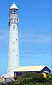
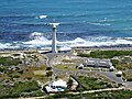
Slangkop Lighthouse
 | |
 | |
| Location | Kommetjie Western Cape South Africa |
|---|---|
| Coordinates | 34°08′55.0″S 18°19′10.0″E / 34.148611°S 18.319444°E |
| Tower | |
| Constructed | 1919 |
| Construction | cast iron tower |
| Height | 33 metres (108 ft) |
| Shape | tapered cylindrical tower with balcony and lantern[2] |
| Markings | white tower and lantern |
| Light | |
| First lit | 4 March 1919 |
| Focal height | 40 metres (130 ft) |
| Intensity | 5,000,000 CD[1] |
| Range | 33 miles (53 km) |
| Characteristic | Fl (4) W 30s. |
Slangkop Lighthouse is a lighthouse near the town of Kommetjie, near Cape Town, South Africa.[3]
History
Construction was due to be completed in 1914 and a brass sign was commissioned for this date, but due to the
First World War the lighthouse was not completed until 1919, although definitely in use before that date, e.g. noted in the log of HMS Himalaya on 19 July 1917.[4] The lighthouse was inaugurated on 4 March 1919.[5] The white circular iron tower stands 33m high.[5]
The lighthouse is a tourist attraction for those visiting the area.
Gallery
-
 Slangkop Lighthouse
 -


See also
References
- ^ "Untitled Document". www.lighthouses.co.za.
- ^ Rowlett, Russ. "Lighthouses of Western South Africa". The Lighthouse Directory. University of North Carolina at Chapel Hill. Retrieved 22 March 2016.
- ^ Viljoen, Joe (2 January 2009). "Lighthouses of South Africa: Slangkop Lighthouse".
- ^ ISBN 9781868425501.
External links
 Media related to Slangkop Lighthouse at Wikimedia Commons
- Video taken from Slangkop Lighthouse on YouTube
| Authority control databases: Geographic |
|
|---|
This lighthouse-related article is a stub. You can help Wikipedia by expanding it. |