
Snake River Canyon (Idaho)
| Snake River Canyon (Idaho) | |
|---|---|
 Snake River Canyon, Idaho | |
 Snake River Canyon (Idaho) Location of Snake River Canyon in Idaho | |
| Geography | |
| Country | United States |
| State | Idaho |
| County |
|
| Coordinates | 42°36′N 114°25′W / 42.600°N 114.417°W |
| River | Snake River |
Snake River Canyon is a
History
In the late 19th century I. B. Perrine and others founded the Magic Valley's first successful agricultural operations on the Snake River Canyon floor. The canyon's value as a farming area diminished after irrigation projects made agriculture practical in the surrounding areas in the early 20th century. Today the canyon floor is a tourist attraction and features several parks and golf courses.
In the past it was generally believed the Snake River Canyon was created by a cataclysmic flood caused by water released from Lake Bonneville approximately 15,000 years ago.[2] However, as of 2000, geologists believe that while the canyon was shaped by the flood, its basic structure predated it.[3]
Local fame
The canyon is well known as the site of an unsuccessful 1974 attempt by Evel Knievel to jump across it in the Skycycle X-2 rocket. The dirt ramp built for that jump is still there and remains a tourist attraction (42°35'49.5"N 114°25'22.3"W).
On September 16, 2016, stuntman Eddie Braun successfully jumped the canyon using technology similar to that used by Evel Knievel 42 years previously.[4]
-
 View west down the Snake River Canyon from Shoshone Falls
 -
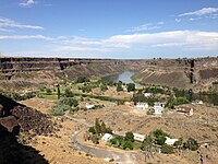
 Looking west down the Snake River Canyon from the Perrine Bridge
 -
 View up the Snake River Gorge above Shoshone Falls


References
- ^ "River of Stone", Magic Valley website. Retrieved June, 2014.
- ^ Dunlap, Tetona. "Anatomy of a Canyon: Dissecting the Panorama". MagicValley.com. Retrieved May 14, 2015.
- ^ Topinka, Lyn. "Lake Bonneville and the Bonneville Flood", Cascades Volcano Observatory, January 22, 2003. Accessed August 18, 2008.
- ^ "Stuntman Eddie Braun makes the jump across the Snake River Canyon". kboi2.com. Sinclair Broadcast Group, Inc. Retrieved 16 September 2016.
External links
![]() Media related to Snake River Canyon (Idaho) at Wikimedia Commons
Media related to Snake River Canyon (Idaho) at Wikimedia Commons
This Jerome County, Idaho state location article is a stub. You can help Wikipedia by expanding it. |
This Twin Falls County, Idaho state location article is a stub. You can help Wikipedia by expanding it. |