
Sohag
This article needs additional citations for verification. (October 2018) |
Sohag
سوهاج | |
|---|---|
UTC+2 (EET) | |
| Postal code | 82749[2] |
| Area code | +20 (Egypt) 93 (City)[3] |
| Website | www |
Sohag (
History
The modern city developed from the village of Suhay (
Geography

Sohag lies on a fertile agricultural plain on the western bank of the Nile,[9] approximately 6 kilometres (3.7 miles) southwest of Akhmim. The city includes two islands; Karaman-ez-Zahur Island is larger and uninhabited, and ez-Zahur Island (جزيرة الزهور, Ǧazīrat az-Zuhur, "Flower Island") has some homes.
Economy
The city Sohag of itself encloses only a few archaeological sites, hence tourism represents but a small portion of the city's income. Other sources of income include trade, small industries of carpets, furniture, spinning and weaving and sugar. Administrative and educational services are two big sectors of income.
Demographics
| 1928 | 1976 | 1986 | 1996 | 2006 | 2012 | 2018 | 2021 | |
|---|---|---|---|---|---|---|---|---|
| 20,760[10] | 101,758 | 132,965 | 170,125 | 189,695 | 201,339 | 248,174 | 266,944 | |
| Starting in 1928: Population of Sohag City[11] | ||||||||
Religion
This article needs additional citations for verification. (December 2013) |
Islam and Christianity are the main religions in Sohag; about 75% of the population are Muslim.[citation needed].
Historical sites
Mosques
- Sidi Arif Mosque (Arabic: مسجد العارف بالله, Masjid al-ʿArif bi-Allah). The mosque is located in the south of the city. The el-ʿArif Mosque was built in the 14th century—the 8th century in the Islamic calendar. The present building was constructed around 1995. At the corners of the façade are two minarets and the roof is crowned by a dome. Inside the five-nave mosque the bases of the piers and the walls were lined with red granite. The ceiling is painted ornamentally; in its middle is an elongated light dome. The southeastern half is lit by chandeliers. At the end are the prayer niche (mihrab) with simple ornaments and to the right of it the wooden pulpit (minbar).
 |
 |
 |
 |
- El-Farshuti Mosque (Arabic: جامع الفرشوطي, Jāmʿi al-Farschūṭī), also named el-'Atiq Mosque (the old mosque) is located approximately 350 metres (1,150 feet) southwest of the Qur'an. The bases of the walls are painted yellow and white with green bands. A very colorful prayer niche next to the wooden pulpit is located at the southeastern side.
In the masonry on the eastern, southern and western sides are stones engraved with historical inscriptions moved from previous buildings, including a decree of the penultimate
 |
 |
 |
 |
Churches
This section needs additional citations for verification. (December 2013) |
Sohag has two important churches that were erected in the 20th century: the Church of the Holy Virgin and the Church of Saint George.
- The Church of the Holy Virgin (Arabic: كنيسة السيدة العذراء, Kanīsat as-Saiyida al-ʿAdraʾ). The church is located in the north of the bazaar (souq Qaiṣarīya). It consists of five naves. There are three sanctuaries for Saint George (left), the Holy Virgin and the Archangel Michael at the ends of the middle three naves. All sanctuaries are completely screened by a wooden iconostasis. On both sides of the entrances to the sanctuaries are wooden icons of the Holy Virgin and Jesus. The Lord's Last Supper and the crosses are located above the iconstasis. The presentation in the central nave is framed by a fish and a pigeon; the other ones are framed by angels and a dove. Galleries are located above the aisles and the entrance. On the walls are paintings of saints and scenes from the life of Jesus.
 |
 |
 |
- Church of St. George is the cathedral of the diocese of Sohag (Arabic: كنيسة مار جرجس, Kanīsat Mar Girgis). The church is located 300 metres (980 feet) north of the Opera (Midan Obira) or Culture Square (Midan eth-Thaqafa).
- Church of the Archangel Michael (Arabic: كنيسة الملاك ميخائيل). The church is located in Railway Station Street (El-Mahatta Street) on the eastern side of the railway tracks.
Monasteries
White Monastery
The Coptic White Monastery is a
Red Monastery
The Red Monastery is a
 |
 |
Temples and cemeteries
Sohag is the site of a temple built for the goddess
Subdivisions
Sohag is informally divided into the East District (Arabic: حى شرق) and the West District (Arabic: حي غرب). Among the most notable regions of the West District are:
- Sidi Aref
- Al Shahid (Arabic for the Martyr)
- Gharb Al-Koubry ("West of the Bridge" neighborhood)
The East District is considered a more upscale district; it includes some of the most affluent neighborhoods of the city including 15th Street, Al Kashef Street, Jumhuriya Street, The Courts Compound, and The Technical and Agricultural Schools. Some of the most notable locales of the East District include:
- The Courts Compound of Sohag
- City Hall of Sohag
- Sohag University
- Sohag Teaching Hospital, one of the biggest hospitals of the region
- Multiple governmental directorates
- Many recreational areas including The Sohag Stadium and many parks including Al Zohour, a revitalized island park located in the middle of the Nile.
- Nasr City, the first satellite city to be built in the East District. It was established during the presidency of Gamal Abdel Nasser.
Climate
The
| Climate data for Sohag | |||||||||||||
|---|---|---|---|---|---|---|---|---|---|---|---|---|---|
| Month | Jan | Feb | Mar | Apr | May | Jun | Jul | Aug | Sep | Oct | Nov | Dec | Year |
| Record high °C (°F) | 30.8 (87.4) |
37.5 (99.5) |
42.2 (108.0) |
43.9 (111.0) |
47.4 (117.3) |
47.9 (118.2) |
47.0 (116.6) |
43.4 (110.1) |
44.4 (111.9) |
43.1 (109.6) |
37.0 (98.6) |
33.3 (91.9) |
47.9 (118.2) |
| Mean daily maximum °C (°F) | 22.0 (71.6) |
23.8 (74.8) |
27.5 (81.5) |
33.6 (92.5) |
37.7 (99.9) |
39.6 (103.3) |
38.8 (101.8) |
37.8 (100.0) |
36.0 (96.8) |
33.7 (92.7) |
28.2 (82.8) |
23.5 (74.3) |
31.9 (89.4) |
| Daily mean °C (°F) | 13.9 (57.0) |
15.6 (60.1) |
18.9 (66.0) |
24.5 (76.1) |
29.1 (84.4) |
30.7 (87.3) |
31.0 (87.8) |
29.9 (85.8) |
27.9 (82.2) |
25.1 (77.2) |
19.8 (67.6) |
15.4 (59.7) |
23.5 (74.3) |
| Mean daily minimum °C (°F) | 7.3 (45.1) |
8.8 (47.8) |
11.8 (53.2) |
16.6 (61.9) |
21.1 (70.0) |
23.1 (73.6) |
24.1 (75.4) |
23.1 (73.6) |
20.6 (69.1) |
17.8 (64.0) |
13.0 (55.4) |
9.2 (48.6) |
16.4 (61.5) |
| Record low °C (°F) | 0.4 (32.7) |
2.6 (36.7) |
3.3 (37.9) |
7.7 (45.9) |
11.5 (52.7) |
15.7 (60.3) |
17.6 (63.7) |
18.0 (64.4) |
15.9 (60.6) |
11.4 (52.5) |
4.8 (40.6) |
2.6 (36.7) |
0.4 (32.7) |
| Average precipitation mm (inches) | 0 (0) |
1 (0.0) |
0 (0) |
0 (0) |
0 (0) |
0 (0) |
0 (0) |
0 (0) |
0 (0) |
0 (0) |
0 (0) |
0 (0) |
1 (0) |
| Average precipitation days | 0.1 | 0.1 | 0.2 | 0.1 | 0 | 0 | 0 | 0 | 0 | 0 | 0 | 0.2 | 0.7 |
| Average relative humidity (%)
|
57 | 50 | 44 | 36 | 30 | 31 | 37 | 43 | 45 | 44 | 51 | 56 | 43.7 |
| Source 1: NOAA[14] | |||||||||||||
| Source 2: Climate Charts[15] | |||||||||||||
Culture
This section needs expansion. You can help by adding to it. (September 2010) |
Language
A version of the
Museums
The Sohag Museum contains about 5,000 artifacts gathered from around the Sohag governorate, including items stretching from the Middle Kingdom to Greco-Roman times.[9][17]
Bazaars
Souq el-Qisareya: The bazaar in Sohag is named suq Qaiṣarīya and is partly covered.
Souq el-Itnein is a weekly market held every Monday morning; vegetables, fruits, animals and traditional hand made objects (like baskets, farming axes and bags) are sold there. The weekly market is believed to have originated during the Ancient Egyptian era. The
Transport

Sohag is linked to Giza and northern cities by the road of Asyut Western Desert, Eastern Desert Road and Rural Road, which also connects it to the railways.[18]
In February 2010, a highway linking Sohag to the Red Sea city Hurghada was opened to ease movement between Upper Egypt and the Red Sea coastal region.[citation needed] In May 2010, the Egyptian President Hosni Mubarak inaugurated Sohag International Airport.[19]
| City | Distance (km) |
|---|---|
| Alexandria | 692 |
| Port Said | 691 |
Ismaïlia
|
616 |
| Suez | 605 |
| Cairo | 471 |
| Aswan | 428 |
| Luxor | 205 |
| Asyut | 98 |
Education

Educational establishments in Sohag include: Primary schools:
- Al-Nasr school
- Huda Sharawi school
- Mulhaqat Al-Mu'allemat school
Middle schools:
- Ahmad Deifalla school
- Nabawi Muhandis school
- Ali Osman Baltak school
- Tarik Ibn Ziad school
High schools:
- Sohag Military school
- Abdelmunim Riad school
- Asmaa Bint Abi Bakr school
- Hag Hadad school
University
Sohag University is a public university with more than 40,000 students[20] located on the eastern side of the city. It was established under the banner of South Valley University but became independent in 2006. There are currently ten colleges in Sohag University.
Sports

The most popular sport in Sohag is
Notable people
Notable people who originate from or live in Sohag include:
- Narmer, The first pharaoh of unified Egypt and the founder of the Early Dynastic Period (c. 32nd century BC).
- Islamic world.
- Al-Azhar.
- Rifa'a el-Tahtawi, writer, teacher, translator, Egyptologist, renaissance intellectual and founder of Madrasat al-Alsun (Tongues School).
- Onsi Sawiris, Billionaire businessman
- Mustafa al-Maraghi, reformer and rector of Al-Azhar Mosque.
- Mohammed Aboul-Fotouh Hassab, gastro-intestinal surgeon.
- Gamal El-Ghitani, author of historical novels and cultural and political commentaries.
- Atef El-Tayeb, film director.
- George Sidhom, film actor.
- Emad Hamdy, Film actor.
- Baligh Hamdi, composer who created hit songs for many prominent Arabic singers.
- Sufisaint considered the Patron Saint of the Physicians in the early Islamic era of Egypt .
- Taghribat Bani Hilal.
Nearby attractions

- Umm el-Qa'ab, a royal necropolis where early pharaohs were entombed.[22]
- Copticchurches. It maintains a weekly market and manufactures cotton goods.
- El-Hawawishis the ancient necropolis (cemetery) for Akhmim.
- El-Salamuni comprises a rock-cut chapel dedicated to the god Min.
- The Meritamen statue in eastern Akhmim.
- Outside Third Dynasty.
- The city Triphis) by Ptolemy XV Caesarionand subsequent Roman Emperors.
Photo gallery
-
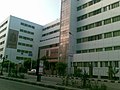
 Building in Sohag
 -
 Roman theater
 -
 Tahtawy memorial
 -
 Sohag city hall
 -
 Jumhuriyea St.
 -
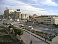
 Orouba sq.
 -
 Skyline.
 -
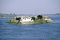 Jazirat Al Zohour .
 -
 Nile view (east bank)
 -
 Courts compound
 -
 Downtown
 -
 Nile view from Akhmim bridge


See also
- Upper Egypt
- Sa'idi people
- Sa'idi Arabic
References
- ^ a b c "Egypt: Governorates, Major Cities & Towns - Population Statistics, Maps, Charts, Weather and Web Information". www.citypopulation.de. Retrieved 17 June 2023.
- ^ "Egypt Postal Code". Egypt-cairo.com. Retrieved 15 October 2017.
- ^ Prozzone. "Sohag, EGYPT :: city code, std code, dial code, country code, long distance". www.prozzone.com. Retrieved 15 October 2017.
- ^ "World Gazetteer: Sohag - profile of geographical entity including nam…". 16 December 2012. Retrieved 15 October 2017.[dead link]
- ISBN 978-0-7864-0729-3. Retrieved 2010-08-07.
- ^ محمد رمزي. القاموس الجغرافي للبلاد المصرية. p. 128.
- ^ "TM Places". www.trismegistos.org. Retrieved 2019-09-01.
- ^ "TM Places". www.trismegistos.org. Retrieved 2022-08-09.
- ^ ISBN 1-84353-050-3.
- ^ Baedeker, Karl; Steindorff, Georg: Ägypten und der Sûdan: Handbuch für Reisende, Leipzig: Baedeker, 1928, 8. ed., p. 221.
- ^ "World Gazetteer: Sohag". Archived from the original on 16 December 2012.
- ^ ISBN 1-86011-163-7.
- ISBN 0-691-03169-X), p. 77.
- ^ "Sohag Climate Normals 1961–1990". National Oceanic and Atmospheric Administration. Retrieved January 17, 2016.
- ^ "Sohag, Egypt: Climate, Global Warming, and Daylight Charts and Data". Climate Charts. Retrieved 9 July 2013.
- S2CID 145655182.
- ^ "The Sohag Museum". Supreme Council of Antiquities - Museums. Retrieved December 14, 2016.
- ^ Vivian, Cassandra (2008-01-01). "Western Desert of The Egypt". The Western Desert of Egypt.
- ^ "Hosni Mubarak | Biography, History, & Facts | Britannica". www.britannica.com. Retrieved 2022-05-25.
- ^ "جامعة سوهاج". Sohag-univ.edu.eg. Retrieved 15 October 2017.
- ^ "El Gouna FC - Misr El Makkasa Live - Summary: Football Scores & Highlights - 17/05/2022". Eurosport. Retrieved 2022-05-25.
- ^ a b "Abydos | ancient city, Egypt | Britannica". www.britannica.com. Retrieved 2022-05-25.
External links
Places adjacent to Sohag | ||||||||||||||||
|---|---|---|---|---|---|---|---|---|---|---|---|---|---|---|---|---|
| ||||||||||||||||
| 1,000,000 and more | |
|---|---|
| 300,000–999,999 | |
| 100,000–299,999 | |
| <99,999 |
|
| Important sites |
| |||
|---|---|---|---|---|
| ||||
| International | |
|---|---|
| National | |