South Atlantic High

South Atlantic High is a semipermanent
subtropical ridge. The centre of the high pressure region tends to follow the seasonal variation in position of the sun
, moving south in the southern summer and north in the southern winter. This affects the climate of the adjacent continental areas, bringing seasonal changes to the climate and weather as the position of the high oscillates.
Formation

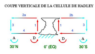
In the
intertropical convergence zone where the warmer air rises because of convergence and relatively lower density. Subsequently, this air spreads north and south and cools at higher altitude and descends further north and south.[1]
Associated weather
This system greatly affects sailing because the associated winds are generally not strong and sailing vessels have to go far north or south of the centre of the high pressure region depending on the direction of travel to find winds that are favourable in strength and direction.[3]
Climatic influence on economy
The anticyclonic circulation produces a dry climate, contributing to the aridity of the
African monsoon and the rainy season in the Guianas.[4]
References
- ^ ISBN 2-7605-0365-8. Retrieved 2009-02-16.
circulation de Hadley.
- ^ "South Atlantic high". Glossary. American Meteorological Society. Retrieved April 18, 2019.
- ^ "L'anticyclone de Sainte Hélène bientôt de retour" (in French). Organisation du Vendée Globe. November 24, 2008. Archived from the original on February 20, 2009. Retrieved 2009-08-03.
- ^ Christine Poixblanc (April 2001). "La Zone de Convergence Intertropicale, qu'est-ce-que c'est ?". La ZIC, responsable des saisons en Guyane (in French). Terres de Guyane. Archived from the original on December 2, 2017. Retrieved 2009-08-02.
