
Southern Cross Drive
- Distinguish from the road of the same name in Cape Town, South Africa, on the eastern side of Table Mountain.
Southern Cross Drive | ||
|---|---|---|
 | ||
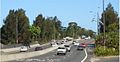
| Aerial view of Southern Cross Drive in 2012, with Botany Lakes and Mill Steam astride the road | ||
 North end South end | ||
| Coordinates | ||
| General information | ||
| Type | Gazetted January 1993[2] | |
| Route number(s) | ||
| Former route number |
| |
| Major junctions | ||
| North end | Kensington, Sydney | |
| ||
| South end | Mascot, Sydney | |
| Location(s) | ||
| Major suburbs / towns | Eastlakes, Pagewood, Rosebery | |
| Highway system | ||
Southern Cross Drive is a 4.8 km (3 mi)
Route
Southern Cross Drive commences at the interchange with South Dowling Street (and the southern end of Eastern Distributor, around 500m beyond) and Link Road and heads south as a 6-lane, dual-carriageway road, tracing past the western border of The Australian Golf Club in Kensington and through The Lakes Golf Club in Eastlakes, before turning westwards over Wentworth Avenue towards the eastern boundary of Sydney Airport, where it turns south again to eventually merge with General Holmes Drive.
With the development of many other motorways and freeways, Southern Cross Drive is part of the 110-kilometre (68 mi)
In August 2013, the Southern Cross Drive carried about 20,000 vehicles per day, both north and southbound.[3]
South of Wentworth Avenue and north of Botany Road, Southern Cross Drive is elevated above the ARTC Southern Sydney Freight Line.[4]
History
Southern Cross Drive was originally built to provide access to the Sydney central business district for suburbs in Southern Sydney and South Eastern Sydney, and originally terminated at Wentworth Avenue at Pagewood. The Gardeners Road bridge was completed in 1969, elevated above Southern Cross Drive at Eastlakes.[5]
A road project to extend Southern Cross Drive further south-west as an elevated roadway over Wentworth Avenue, Botany and Mill Pond Roads – and over reclaimed swampland including Mill Pond, Mill Steam, and Botany Dams, much of which has been reclaimed for golf courses (including the Eastlakes Golf Club, The Lakes Golf Club and Bonnie Doon Golf Club) – to connect directly to General Holmes Drive on the eastern border of Sydney Airport, opened in February 1988.
The passing of the Main Roads Act of 1924[6] through the Parliament of New South Wales provided for the declaration of Main Roads, roads partially funded by the State government through the Main Roads Board (later the Department of Main Roads, and eventually Transport for NSW). With the subsequent passing of the Main Roads (Amendment) Act of 1929[7] to provide for additional declarations of State Highways and Trunk Roads, the Department of Main Roads (having succeeded the MRB in 1932) extended the southern end of Main Road 593 from its old terminus on South Dowling Street at the intersection with O'Dea and Todman Avneues further along South Dowling Street and along the entire length of Southern Cross Drive on 22 January 1993.[2] Despite its role as a grade-separated expressway, the road is not officially gazetted as one by Transport for NSW classification, and is still considered today to be a main road.[8]
The passing of the Roads Act of 1993[9] updated road classifications and the way they could be declared within New South Wales. Under this act, Southern Cross Drive retains its declaration as part of Main Road 593.[8]
The route was allocated State Route 64 in 1974; when the Southern Cross Drive extension opened in 1988, it was extended along with it.[10] It was replaced by National Route 1 when the Sydney Harbour Tunnel opened in 1992, then by Metroad 1 in 1993.[11] With the conversion to the newer alphanumeric system in 2013, Metroad 1 was replaced by route M1.[12]
There were plans to construct south-facing ramps from Gardeners Road to Southern Cross Drive, proposed in 2005.[13][14]
Exits and interchanges
| LGA | Location | km[1] | mi | Destinations | Notes |
|---|---|---|---|---|---|
Sydney CBD, North Sydney | Northern terminus of road, route M1 continues north along South Dowling Street | ||||
| Link Road – Rosebery | Northbound entrance and exit only | ||||
| Bayside | Eastlakes–Mascot–Pagewood tripoint | 3.2 | 2.0 | Wentworth Avenue – Maroubra, Mascot | Northbound entrance and southbound exit only |
| Mascot–Pagewood–Botany tripoint | 4.4 | 2.7 | Southern Sydney Freight Line | ||
| Mascot | 4.5 | 2.8 | Botany Road – Botany, Mascot, Arncliffe | Northbound entrance and southbound exit only | |
Wollongong | Southern terminus of road, route M1 continues southeast along General Holmes Drive | ||||
1.000 mi = 1.609 km; 1.000 km = 0.621 mi
| |||||
Gallery
-
 Southern Cross Drive, southerly direction, at the Link Road entrance. Also visible are lane markings notifying motorists of the approaching entrance to Eastern Distributor
 -
 Crossing over Wentworth Avenue with surrounding golf courses.


See also
- Freeways in Sydney
- Southern Cross (aircraft)
References
- ^ a b Google (12 July 2023). "Southern Cross Drive" (Map). Google Maps. Google. Retrieved 12 July 2023.
- ^ a b "State Roads Act". Government Gazette of the State of New South Wales. No. 7. National Library of Australia. 22 January 1993. pp. 223–30. Archived from the original on 27 March 2023. Retrieved 11 July 2023.
- Roads & Maritime Services. April 2016. p. 30. Retrieved 8 October 2016.
- Roads & Maritime Services. p. 20. Retrieved 8 October 2016.
- ^ "Metroads: Steel bridges". The History of Sydney: Late 20th Century: 1946 - 2000. Visit Sydney Australia. 2015. Retrieved 8 October 2016.
- ^ State of New South Wales, An Act to provide for the better construction, maintenance, and financing of main roads; to provide for developmental roads; to constitute a Main Roads Board Archived 11 August 2022 at the Wayback Machine 10 November 1924
- ^ State of New South Wales, An Act to amend the Main Roads Act, 1924-1927; to confer certain further powers upon the Main Roads Board; to amend the Local Government Act, 1919, and certain other Acts; to validate certain payments and other matters; and for purposes connected therewith. Archived 12 August 2022 at the Wayback Machine 8 April 1929
- ^ a b Transport for NSW (August 2022). "Schedule of Classified Roads and Unclassified Regional Roads" (PDF). Government of New South Wales. Archived from the original (PDF) on 25 August 2022. Retrieved 1 August 2022.
- ^ State of New South Wales, An Act to make provision with respect to the roads of New South Wales; to repeal the State Roads Act 1986, the Crown and Other Roads Act 1990 and certain other enactments; and for other purposes. Archived 11 August 2022 at the Wayback Machine 10 November 1924
- ^ "NSW State Route 64: Deccommissioned". OzRoads: The Australian Roads. Retrieved 8 October 2016.[self-published source]
- ^ "NSW Metroad 1: Former Alignment: Southern Cross Drive to Cahill Expressway". OzRoads: The Australian Roads. Retrieved 8 October 2016.[self-published source]
- ^ "Road number and name changes in Sydney" (PDF). Roads and Maritime Services. Transport for NSW - Roads and Maritime. 2013. Archived from the original (PDF) on 1 April 2019. Retrieved 23 July 2020.
- Roads & Maritime Services. Archived from the originalon 9 June 2008.
- ^ "RTA Annual Report 2006 Appendices" (PDF). Roads & Traffic Authority. 30 June 2006. p. 151. Retrieved 8 October 2016.