
Southern Patagonian Ice Field
| Southern Patagonian Ice Field | |
|---|---|
 | |
 Location within Southern Patagonia | |
| Type | Ice field |
| Location | Southern Patagonia, Argentina and Chile |
| Coordinates | 49°55′S 73°32′W / 49.917°S 73.533°W |
| Area | 16,800 km2 (6,500 sq mi) |
| Status | Retreating |
The Southern Patagonian Ice Field (
Geography

The Southern Patagonia Ice Field extends from parallels 48° 15′ S to 51° 30′ S for approximately 350 kilometres (220 mi), and has an approximate area of 16,480 km2 (6,360 sq mi), of which 14,200 km2 belong to Chile and 2,600 km2 belong to Argentina.[a]
The ice mass feeds dozens of glaciers in the area, among which are the
An important part of the ice field is protected under different national parks, such as the Bernardo O'Higgins and Torres del Paine in Chile, and the aforementioned Los Glaciares in Argentina.
There are two known volcanoes under the ice field;
Circo de los Altares is an important hiking place.
History
Exploration
Thorough explorations include the expeditions of
From the air, initial exploration was conducted in 1928–29 by Gunther Plüschow after whom a glacier is named. From April 1944 to April 1945, the United States Army Air Forces conducted an aerial survey using the Trimetrogon method at the request of the Chilean government.[3]
Borderline


Although the boundary between Argentina and Chile in the area was established by the
The
In 1994, the Laguna del Desierto dispute was solved which involved territory of the Ice Field, an international tribunal awarded almost the whole zone to Argentina.[10][11] After a refused appeal in 1995, Chile accepted the award. Since then, Chile has a small corridor to access Mount Fitz Roy and the Marconi Pass was defined as an international border crossing point.
The Southern Patagonian Ice Field section of the border is the last remaining border issue between Chile and Argentina. On August 1, 1991, the governments of Chile and Argentina agreed on a borderline, but the agreement was never ratified by the Argentine legislature. Later, in 1998, both governments agreed to redraw the borderline between
Section A (between
Controversies after the 1998 Agreement
In February 2006, Ricardo Lagos[14] appeared in a photo with the head of the Air Force, General Osvaldo Sarabia, in the undemarcated area, this caused controversy with Argentina.[15]
In 2006, the Argentine Instituto Geográfico Militar (IGM) (today Instituto Geográfico Nacional) edited a map without a note about the nondefined border but showed the Argentine claims as the official borderline. After Chilean diplomatic protests, the Argentine government withdrew the map and urged Chile to expedite the demarcation of the international border according to the 1998 agreement.[16][17] On August 24, 2006, the Argentine Undersecretary of Tourism stated that the maps used by the Secretariat of Tourism's website were official because they were approved by the National Geographic Institute of Argentina.[18][19][20][21]
In 2006, president of Chile Michelle Bachelet and president of Argentina Néstor Kirchner held a meeting over the cartographic controversy.[22] Kirchner served as the governor of the Santa Cruz Province from 1991 to 2003.[23]

In the maps published in Argentina, until today, the region continues to be shown without the white rectangle, as can be seen in a map of Santa Cruz on a website of an official Argentine agency.[24] While in the official Chilean maps and most tourist maps, the rectangle is shown and it is clarified that the boundary is not demarcated according to the 1998 treaty.[25][26][27]
In 2018, Argentina made a National Ice Inventory in which are included some disputed glaciers.[28][29][30][31] From September 20 to October 4 of the same year, the Argentine army traveled to into the area that is pending to be demarcated. This caused controversy mainly in Chile[32] where the mayor of Villa O'Higgins denounced the fact as a "provocation" and made a call to the central government of Chile to reinforce the sovereignty in the zone.[33][34]
After the Argentine government published its inventory of glaciers including undefined territory the Chilean Foreign Ministry informed that a claim note had already been sent denying the Argentine inventory.
In 2021, there was a controversy since
As of 2024, the demarcation is still pending.[36]

Gallery
-
 Fjord in Chile
 -
 Lake and Glacier Onelli, Santa Cruz, Argentina
 -
 Lake Bergues, Aysén, Chile
 -
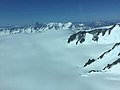 Southern Patagonian Ice Field
 -
 Perito Moreno Glacier, Santa Cruz, Argentina
 -
 Pío XI Glacier, Magallanes & Chilean Antarctica, Chile
 -
 Upsala Glacier, Argentina-Chile
 -
 O'Higgins Glacier, Aysén, Chile


See also
- Southern Patagonian Ice Field dispute
- Northern Patagonian Ice Field
- Circo de los Altares
- List of glaciers
- Beagle conflict
- Puna de Atacama dispute
- Glaciarium (museum)
Notes
- ^ The area includes regions included in the official cartography of Argentina, which is still pending demarcation, see the section on the dispute.[2]
References
- Kluane / Wrangell–St. Elias / Glacier Bay / Tatshenshini-Alsek Ice Field. "Kluane / Wrangell-St. Elias / Glacier Bay / Tatshenshini-Alsek". UNESCO. Archived from the originalon 2017-02-24.
- ^ "Biblioteca del Congreso Nacional | Ley Chile". Archived from the original on 2021-08-27. Retrieved 2021-08-28.
- ^ Lliboutry, Louis (1998). Williams, Richard S. Jr.; Ferrigno, Jane G. (eds.). Satellite Image Atlas of Glaciers of the World | South America | United States Geological Survey Professional Paper 1386-I (PDF) (Report). United States Geological Survey. p. I120. Archived (PDF) from the original on 2021-08-19. Retrieved 2023-12-11.
- ^ Francisco Pascasio Moreno(1902). Frontera Argentino-Chilena - Volumen II (in Spanish). pp. 905–911.
- ^ a b Arbitraje de Limites entre Chile i la Republica Arjentina - Esposicion Chilena - Tomo IV (in Spanish). Paris. 1902. pp. 1469–1484.
{{cite book}}: CS1 maint: location missing publisher (link) - ^ a b Diego Barros Arana (1898). La Cuestion de Limites entre Chile i la Republica Arjentina (in Spanish). Santiago de Chile.
{{cite book}}: CS1 maint: location missing publisher (link) - ^ Santis, 1995:3–7
- ^ Juan Ipinza (26 April 2021). "El Campo de Hielo Patagónico Sur ¿es mejor un mal arreglo que un buen juicio". Info Defensa. Retrieved 8 September 2022.
- JSTOR 1774365.
I have seen it descending from the west as an immense ice field, from the crest of the central chain, 3000 meters high, which the ice covers to its western slope in the Eyre Strait. To the south and north of it, other narrower glaciers can be seen at the extremity of the fjord-like bays.
- ^ "The Laguna del Desierto case". Jusmundi. Retrieved 2 February 2023.
- ^ "Boundary dispute between Argentina and Chile concerning the frontier line between boundary post 62 and Mount Fitzroy" (PDF). Legal UN. 21 October 1994. Retrieved 2 February 2023.
- ^ "Border agreement between Chile and Argentina". 1998. Archived from the original on 2008-05-12. Retrieved 2006-10-27.
- ^ "Map showing border between Chile and Argentina (partly undefined)". Archived from the original on 2019-10-02. Retrieved 2016-06-26.
- ^ "Lagos comenzó gira que lo hará recorrer todas las comunas del país" (in Spanish). Cooperativa. February 1, 2006. Retrieved 5 February 2023.
- ^ "Revelan fallidas tratativas del gobierno de Bachelet por Campos de Hielo" (in Spanish). La Tercera. May 20, 2010. Archived from the original on 2020-08-15.
- ^ "Subsecretario argentino de turismo dice que mapa de Campos de Hielo es oficial". Emol. August 29, 2006. Retrieved 5 February 2023.
- ^ ""Puede tratarse de un error"" (in Spanish). Austral Temuco. August 25, 2006. Archived from the original on 2020-08-11. Retrieved 5 February 2023.
- ^ "Argentina aseguró que su mapa de Campos de Hielo Sur es oficial". Cooperativa. August 29, 2006. Retrieved 2 February 2023.
- ^ "Hielos Continentales: reclamo de Chile por los mapas argentinos". Clarín. August 29, 2006.
- ^ "Tras la fricción por los Hielos Continentales, la Argentina llama a Chile a demarcar los límites "lo antes posible"". El Clarín. August 30, 2006. Archived from the original on 2013-07-14.
- ^ "SECRETARÍA DE TURISMO ARGENTINA AVALA MAPA CON ERROR EN CAMPOS DE HIELO". La Nación. August 20, 2006. Archived from the original on 2016-04-27. Retrieved 5 February 2023.
- ^ "Legisladores ven con buenos ojos encuentro entre Bachelet y Kirchner" (in Spanish). El Mostrador. September 12, 2006. Retrieved 5 February 2023.
- ^ "Nestor Kirchner". Biografías y vidas.
- ^ Map of Santa Cruz in an official Argentine agency.
- . Retrieved 28 November 2023.
- ^ "Campo de Hielo Sur [material cartográfico] Instituto Geográfico Militar". Biblioteca Nacional (Chile). Retrieved 6 February 2023.
- ^ "Mapa Turístico de la XII Región de Magallanes y La Antártica Chilena ..:: Antes de viajar, navegue... Turismovirtual.cl ::." www.turismovirtual.cl.
- ^ "Argentina publica inventario de glaciares e incluye a hielos que están en territorio chileno". 2018-10-15. Archived from the original on 2018-10-26. Retrieved 2018-10-25.
- ^ "Subcuenca del Lago Viedma - Inventario Nacional de Glaciares" (PDF). Archived (PDF) from the original on 2018-09-05. Retrieved 2018-10-25.
- ^ "Subcuenca Brazo Norte del Lago Argentino - Inventario Nacional de Glaciares" (PDF). Archived (PDF) from the original on 2018-09-05. Retrieved 2018-10-25.
- ^ "Subcuencas Brazo Sur del Lago Argentino y río Bote - Inventario Nacional de Glaciares" (PDF). Archived (PDF) from the original on 2018-09-05. Retrieved 2018-10-25.
- ^ "Malestar en Chile por un ejercicio militar de la Argentina en la zona de Hielos Continentales". 11 October 2018. Archived from the original on 2018-10-26. Retrieved 2018-10-25.
- ^ "Advierten expedición militar argentina en demarcación limítrofe pendiente en Campo de Hielo Sur". 11 October 2018. Archived from the original on 2018-10-26. Retrieved 2018-10-25.
- ^ "Polémica por incursión de ejército argentino en territorio chileno en Aysén". 11 October 2018. Archived from the original on 2018-10-26. Retrieved 2018-10-25.
- ^ "¿Nuevo conflicto con Chile? Un domo de montaña en los Hielos Continentales amenaza con renovar tensiones" (in Spanish). La Nación. September 10, 2021.
- ^ "El Campo de Hielo Patagónico Sur ¿es mejor un mal arreglo que un buen juicio". Info Defensa. Retrieved 28 December 2022.
External links
- Expedición Transpatagonia 2007, Campo de Hielo Patagónico Sur. Primera exploración histórica del Cordón del Gaviotín y del Lago Greve
- Expeditions in the SP Ice Field
- "Glaciers of the Wet Andes" by Louis Lliboutry, USGS
- South Patagonian Icefield, NASA Earth Observatory, 2017. Includes new satellite imagery.
- Subsecretario argentino de turismo dice que mapa de Campos de Hielo es oficial Archived 2019-08-09 at the Wayback Machine "El Mercurio", Chile 29 August 2006
- Hielos Continentales: reclamo de Chile por los mapas argentinos Clarín, Argentina 29 August 2006
- Tras la fricción por los Hielos Continentales, la Argentina llama a Chile a demarcar los límites "lo antes posible" Clarín, 30 August 1996
| Rivers | .png) | |
|---|---|---|
| Lakes |
| |
| Glaciers | ||
| Rivers | ||
|---|---|---|
| Waterfalls | ||
| Lakes | ||
| Glaciers | ||