
Southern Peninsula (Iceland)
Suðurnes | |
|---|---|
 The Suðurnes area | |
| Coordinates: 63°55′N 22°15′W / 63.917°N 22.250°W | |
| Country | Iceland |
| Seat | Keflavík |
| Area | |
| • Total | 829 km2 (320 sq mi) |
| Population (2020) | |
| • Total | 27,829 |
| • Density | 24.5/km2 (63/sq mi) |
| ISO 3166 code | IS-2 |

Southern Peninsula (Icelandic: Suðurnes, Icelandic pronunciation: [ˈsʏːðʏrˌnɛːs] ⓘ) is an administrative unit and part of Reykjanesskagi (pronounced [ˈreiːcaˌnɛsˌskaijɪ]), or Reykjanes Peninsula, a region in southwest Iceland. It was named after Reykjanes, the southwestern tip of Reykjanesskagi.[1]
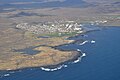
The region has a population of 27,829 (2020) and is one of the more densely populated parts of the island. The administrative centre is Keflavík, which had 7,000 residents when it merged with the nearby town of Njarðvík and Hafnir in 1995 to create Reykjanesbær, which is the largest settlement outside the Greater Reykjavík area; in 2018 the region had a population of 17,805.[2] The region is the location of Keflavík International Airport, the major point of entry for Iceland.[3][4] Some fishing towns, such as Grindavík, Njarðvík and Sandgerði, are situated on the peninsula.
The peninsula is marked by active
The Bridge Between Continents spans the Álfagjá [ˈaulvaˌcauː] rift valley (60 feet (18 m) wide and 20 feet (6.1 m) deep) near Grindavík, which is promoted to tourists as marking the boundary between the Eurasian and North American tectonic plates. It was built in 2002 and previously named Leif the Lucky bridge in honor of Icelandic explorer Leif Eriksson who traveled from Europe to America nearly 500 years before Christopher Columbus.[7]
A great deal of volcanic unrest was occurring in this part of the Reykjanes Peninsula from 2020 onward, after nearly 800 years of inactivity. After the eruption of the
Reykjanes volcanic belt
| Reykjanes volcanic belt | |
|---|---|
,_Reykjanes_peninsula.JPG) The Reykjanes volcanic belt is almost completely covered by lava fields. | |
| Highest point | |
| Coordinates | 63°52′12″N 22°33′30″W / 63.87000°N 22.55833°W |
| Geography | |
 Map of volcanic systems on the Reykjanes Peninsula. 1) Reykjanes, 2) Svartsengi, 3) Fagradalsfjall, 4) Krýsuvík, 5) Brennisteinsfjöll, and 6) Hengill
| |
| Location | Reykjanes Peninsula, Iceland |
| Parent range | Mid-Atlantic Ridge |
| Geology | |
| Mountain type | fissure |
| Last eruption | 2023 CE[11] |
The Southern Peninisula contains the south western portion of the Reykjanes volcanic belt, where the continuation of the
Gallery
-
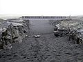 Leif the LuckyBridge spanning the Álfagjá rift valley
 -
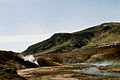
 Reykjanesvirkjungeothermal power plant
 -
-
-
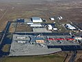 Keflavík International Airport
 -
 Litli-Hrútur eruption 2023. View from an airplane


,_Grindav%C3%ADk.JPG)


See also
References
- ^ "Reykjanes Peninsula". visitreykjanes.is. Retrieved December 1, 2019.
- ^ "Information about Keflavík". guidetoiceland.is. Retrieved December 1, 2019.
- ^ "Keflavik International Airport". isavia.is. Retrieved December 1, 2019.
- ^ "Leifur Eriksson Air Terminal". lsretail.com. Retrieved December 1, 2019.
- ^ "Krysuvik geothermal area". icelandtravel.is. Retrieved December 1, 2019.
- ^ "Svartsengi power plant". verkis.com. Retrieved December 1, 2019.
- ^ "Bridge Between Continents". icelandtravel.is. Retrieved December 1, 2019.
- PMID 35768436.
- ^ "Eruption in Iceland may mark the start of decades of volcanic activity". Archived from the original on March 22, 2021. Retrieved 27 March 2021.
- ^ "Iceland declares state of emergency over volcanic eruption threat: Powerful earthquakes rock country's southwestern Reykjanes peninsula, increasing likelihood of event". The Guardian. 10 November 2023. Retrieved 10 November 2023.
- ^ December 19, 2023 - Iceland volcano erupts
- ^ Thor Thordarson, Armann Hoskuldsson: Iceland. Classic geology of Europe 3. Harpenden 2002, p.48-49, eg.
- ^ a b Sigurgeirsson, Magnús Á.; Einarsson, Sigmundur (2019). "Catalogue of Icelandic Volcanoes - Reykjanes and Svartsengi volcanic systems". Icelandic Meteorological Office, Institute of Earth Sciences at the University of Iceland, Civil Protection Department of the National Commissioner of the Iceland Police. Retrieved 29 December 2023.
- ^ Icelandic Met Office. Aviation colour code. Retrieved 17. August 2020.
- ^ Jillian Mary Verbeurgt: A comparative analysis of the magnetic anomalies associated with the geothermal systems on Reykjanes peninsula. Master of Science (M.Sc.) in Sustainable Energy Science. Haraldur Auðunsson, Supervisor. Reykjavík University. September 2019 Retrieved 17. August 2020.
- ^ Thor Thordarson, Armann Hoskuldsson: Iceland. Classic geology of Europe 3. Harpenden 2002, p.14 and 63.
- ^ Helgi Páll Jónsson: Eldfjallagarður og jarðminjasvæði á Reykjanesskaga. Jarðvísindadeild Háskóli Íslands 2011. MS ritgerð. Leiðbeinendur Ólafur Ingólfsson. Skoðað 17. ágúst 2020.
External links
- Photography
- http://isafold.de/reykjavegur01/img_sveifluhals.htm
- http://isafold.de/reykjavegur01/img_pass.htm
- http://isafold.de/reykjavegur01/img_keilir.htm
- http://isafold.de/reykjavegur01/img_dampf.htm
- http://icelandiscool.com/photos/islandpictures.htm
| History |
|  | |||||
|---|---|---|---|---|---|---|---|
| Geography |
| ||||||
| Politics | |||||||
| Economy | |||||||
| Society |
| ||||||
| National | |
|---|---|
| Geographic | |