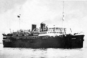
Soviet hospital ship Armenia
 Armenia, before 1941
| |
| History | |
|---|---|
| Name | Armenia |
| Namesake | Armenia |
| Builder | Baltic Shipyard, Leningrad |
| Commissioned | 1928 |
| Out of service | sunk 7 November 1941 |
| Fate | Sunk by He 111 torpedo bombers |
| General characteristics | |
| Class and type | Adzharia-class |
| Type | transport/hospital ship |
| Tonnage | 4,727 GRT[1] |
| Length | 112 m (367 ft) |
| Beam | 15.5 m (51 ft) |
| Draught | 5.5 m (18 ft 1 in) |
| Installed power | Russkiy Dizel 2 × 1472 |
| Propulsion | twin shaft, 105rpm |
| Speed | 13 knots (24 km/h; 15 mph) |

The Soviet hospital ship Armenia (Russian: теплоход «Армения», romanized: teplokhod "Armeniya") was a transport ship operated by the Soviet Union during World War II to carry both wounded soldiers and military cargo. It had originally been built as a passenger ship for operations on the Black Sea.
Armenia was sunk on 7 November 1941 by German aircraft while evacuating civilians and wounded soldiers from Crimea. It has been estimated that approximately 5,000 to 7,000 people were killed during the sinking, making it one of the deadliest maritime disasters in history. There were only 8 survivors.
Career
Armenia, built in 1928 at Baltic Shipyards in
Following the
Sinking

On the night of 6/7 November 1941 Armenia took on thousands of passengers at Sevastopol, amid scenes of chaos. Although the city would end up withstanding the German siege for nine months before falling, at the time enemy seizure appeared imminent. Entire Soviet hospital staffs and civilian officials and their families were taken aboard alongside the thousands of wounded, bound for the town of Tuapse, 400 kilometres (250 mi) away on the northeastern shore of the Black Sea. After leaving port in the early morning hours of the 7th, Armenia's captain, Vladimir Plaushevsky, received orders to put in at Yalta, a few kilometres east of Sevastopol, where the already overloaded ship was to pick up yet more passengers. Here, no attempt was made at registering the embarkees; wounded soldiers and civilians were simply crammed onto the decks. Plaushevsky was eager to get underway while darkness still provided some protection, but was ordered to wait for escorts to arrive. At 07:00 Armenia finally departed Yalta, accompanied by two armed boats and two fighter planes.[4][self-published source]
The Germans and their Romanian and Italian allies had only a few surface vessels on the Black Sea; as such, it remained essentially under Soviet control throughout the Second World War. However, in the earlier part of the war the Axis had complete
Armenia's status as a hospital ship was jeopardized. Though her sides and top were painted with large red cross symbols, she had light anti-aircraft armament, had previously transported troops and military stores, and, on the morning of 7 November, was traveling with military escort, inadequate though it was.[4][self-published source]
At 11:30, about 40 km (25 mi) from Yalta, Armenia was attacked by a Heinkel He 111 medium bomber of 1.Staffel (Lufttorpedo)/KG 28,[6] under the command of Ernst-August Roth, which dropped two torpedoes. One torpedo missed; the other scored a direct hit. The ship broke in two and sank within four minutes. Only eight people were rescued.[7]
Even by the lowest estimate of about 5,000 dead, the sinking of Armenia remains the deadliest maritime disaster in Russian and Soviet history. In terms of loss of life in the sinking of a single ship, it is often listed as third worst in world history, after the sinking of the Wilhelm Gustloff and the Goya, German naval ships transporting military personnel and civilian refugees, which were torpedoed by Soviet submarines in the Baltic Sea in 1945.[8]
In 2014, an Australian company GeoResonance claimed to have located the hulk of Armenia in 2005 at a depth of 520m,[9] using an undisclosed remote sensing technique. However this claim has not been substantiated. All four of the Armenia's sister ships where sunk in the war.
In 2020 the Russian Geographical Society claimed to have located the hulk of Armenia.[10]
References
- ^ a b c d Andrey Nelogov, Soviet Merchant Marine Losses in WW2 (Black Sea) Archived 28 March 2019 at the Wayback Machine, Ships Nostalgia, 11 November 2012
- ^ World War II, C.L. Sulzberger, p. 249, American Heritage Pub. Co., 1966
- ^ C. Peter Chen. "Battle of Sevastopol | World War II Database". Ww2db.com. Retrieved 18 February 2016.
- ^ a b c admin (7 November 2011). "Hospital ship torpedoed by the Nazis – the Sinking of the ArmeniaHistory in an Hour". Historyinanhour.com. Archived from the original on 1 August 2018. Retrieved 18 February 2016.[self-published source]
- ^ "Soviet Storm: World War II – In The East. ep.3. The Defence of Sevastopol". Archived from the original on 3 December 2013. Retrieved 5 July 2016 – via YouTube.
- ISBN 978-1-85780-279-5.
- ^ "WRECKSITE – ARMENIA PASSENGER SHIP 1928–1941". Wrecksite.eu. 27 October 2014. Retrieved 18 February 2016.
- ^ "Wreck Wrak Epave Wrack Pecio". Wrecksite.eu. Retrieved 18 February 2016.
- ^ "GeoResonance Survey Projects". Georesonance.com. Retrieved 18 February 2016.
- ^ "На дне Черного моря обнаружили теплоход "Армения"". ТАСС.
Bibliography
- Budzbon, Przemysław; Radziemski, Jan & Twardowski, Marek (2022). Warships of the Soviet Fleets 1939–1945. Vol. III: Naval Auxiliaries. Barnsley, UK: Seaforth Publishing. ISBN 978-1-3990-2281-1.
