
Junk Bay: Difference between revisions
Extended confirmed users 2,075 edits |
Rescuing 1 sources and tagging 0 as dead. #IABot (v1.6.1) (Feminist) |
||
| Line 26: | Line 26: | ||
'''Tseung Kwan O''' (also called '''Cheung Kwan O''' or '''Junk Bay''') is a bay in [[Sai Kung District]], [[New Territories]], [[Hong Kong]]. In the northern tip of the bay lies the [[Tseung Kwan O Village]]. |
'''Tseung Kwan O''' (also called '''Cheung Kwan O''' or '''Junk Bay''') is a bay in [[Sai Kung District]], [[New Territories]], [[Hong Kong]]. In the northern tip of the bay lies the [[Tseung Kwan O Village]]. |
||
The [[Tseung Kwan O New Town]], one of the nine [[New towns of Hong Kong|new town]]s in [[Hong Kong]], was mainly built on [[Land reclamation in Hong Kong|reclaimed land]] in the northern half of the bay. The current population as of 2011 is about 368,000.<ref>http://www.cedd.gov.hk/eng/about/achievements/regional/regi_tko.htm</ref> |
The [[Tseung Kwan O New Town]], one of the nine [[New towns of Hong Kong|new town]]s in [[Hong Kong]], was mainly built on [[Land reclamation in Hong Kong|reclaimed land]] in the northern half of the bay. The current population as of 2011 is about 368,000.<ref>{{cite web |url=http://www.cedd.gov.hk/eng/about/achievements/regional/regi_tko.htm |title=Archived copy |accessdate=2007-02-10 |deadurl=yes |archiveurl=https://web.archive.org/web/20070211120930/http://www.cedd.gov.hk/eng/about/achievements/regional/regi_tko.htm |archivedate=2007-02-11 |df= }}</ref> |
||
==Name== |
==Name== |
||
Revision as of 14:02, 21 December 2017
Tseung Kwan O | |
|---|---|
| Location of Tseung Kwan O | |
| Country | Hong Kong |
| Region | New Territories |
| District | Sai Kung |
| Population (2011) | |
| • Total | 368,000 |
| Tseung Kwan O | |
|---|---|
Hanyu Pinyin | Jiāngjūn'ào |
| Yue: Cantonese | |
| Jyutping | zoeng1 gwan1 ou3 |
| IPA | [tsœ́ːŋ kʷɐ́n ʔōu] |

Tseung Kwan O (also called Cheung Kwan O or Junk Bay) is a bay in Sai Kung District, New Territories, Hong Kong. In the northern tip of the bay lies the Tseung Kwan O Village.
The
Name
In Cantonese, Tseung Kwan (將軍) means the "general" of an army, and O (澳) means "bay". Therefore, Tseung Kwan O literally means "general's Bay".
The exact origin of the name Tseung Kwan O is unknown, but it is said to be named in honour of a
The current town center of Tseung Kwan O stands on reclaimed land. The English name Junk Bay was said to be derived from the existence of junks in the bay, and the reclamation land based on the landfill [citation needed]. The first landfill was opened in 1978, decades after Junk Bay was named.[2] The Fat Tong Chau (Junk Island) is in the southeastern part of the bay.
History and geography

The bay is near the eastern mouth of Hong Kong's Victoria Harbour. A local gazette: Genuine record of Guangdong province ( Chinese traditional: < 粵大記> ) clearly contained the place name: 將軍澳 (Chinese characters of Tseung Kwan O). Genuine record of Guangdong province published in Ming Dynasty, therefore, we can be sure there were residents inhabited in Tseung Kwan O area during Ming Dynasty.
Before the development of the new town, the area around the bay was occupied by a number of fishing towns and villages. Settlements in the area began as early as in the 13th Century, 800 years ago. Major settlements, however, did not occur until the late 16th Century when small fishing villages were founded in the area. Hang Hau quickly emerged into a market town and became the most populated and prosperous place in the whole of Clear Water Bay Peninsula, and continued for the next few centuries as such.
The
Now Tseung Kwan O has been developed to be including four main areas, Po Lam, Hang Hau, Tseung Kwan O and Tiu Keng Leng.
Climate
| Climate data for Tseung Kwan O (1992–2016) | |||||||||||||
|---|---|---|---|---|---|---|---|---|---|---|---|---|---|
| Month | Jan | Feb | Mar | Apr | May | Jun | Jul | Aug | Sep | Oct | Nov | Dec | Year |
| Record high °C (°F) | 28.0 (82.4) |
28.5 (83.3) |
29.6 (85.3) |
31.8 (89.2) |
34.4 (93.9) |
35.5 (95.9) |
36.4 (97.5) |
37.6 (99.7) |
35.8 (96.4) |
34.5 (94.1) |
32.1 (89.8) |
28.8 (83.8) |
37.6 (99.7) |
| Mean daily maximum °C (°F) | 18.4 (65.1) |
19.0 (66.2) |
20.9 (69.6) |
24.6 (76.3) |
28.0 (82.4) |
30.2 (86.4) |
31.3 (88.3) |
31.3 (88.3) |
30.2 (86.4) |
28.0 (82.4) |
24.6 (76.3) |
20.4 (68.7) |
25.6 (78.1) |
| Daily mean °C (°F) | 15.4 (59.7) |
16.2 (61.2) |
18.3 (64.9) |
22.0 (71.6) |
25.4 (77.7) |
27.5 (81.5) |
28.3 (82.9) |
28.0 (82.4) |
27.0 (80.6) |
24.8 (76.6) |
21.5 (70.7) |
17.1 (62.8) |
22.6 (72.7) |
| Mean daily minimum °C (°F) | 13.0 (55.4) |
14.1 (57.4) |
16.3 (61.3) |
20.1 (68.2) |
23.4 (74.1) |
25.5 (77.9) |
25.9 (78.6) |
25.6 (78.1) |
24.8 (76.6) |
22.5 (72.5) |
19.1 (66.4) |
14.5 (58.1) |
20.4 (68.7) |
| Record low °C (°F) | 2.1 (35.8) |
4.3 (39.7) |
7.0 (44.6) |
9.8 (49.6) |
15.1 (59.2) |
19.9 (67.8) |
21.9 (71.4) |
22.4 (72.3) |
19.2 (66.6) |
14.4 (57.9) |
8.9 (48.0) |
4.0 (39.2) |
2.1 (35.8) |
| Average precipitation mm (inches) | 33.2 (1.31) |
50.5 (1.99) |
78.1 (3.07) |
151.5 (5.96) |
304.0 (11.97) |
508.8 (20.03) |
382.8 (15.07) |
424.2 (16.70) |
302.8 (11.92) |
95.0 (3.74) |
47.4 (1.87) |
28.3 (1.11) |
2,406.6 (94.75) |
| Average relative humidity (%)
|
73 | 80 | 82 | 86 | 86 | 86 | 83 | 85 | 81 | 75 | 74 | 70 | 80 |
| Source: Hong Kong Observatory[5] | |||||||||||||
Development of Tseung Kwan O
In 1983, development of Phase I of the New Town to an initial population of about 175,000 was formally endorsed. By 1986, construction of the two tubes of Tseung Kwan O Tunnel began, which provided potential for further increasing the population of the New Town. To maximize the utilization of the road infrastructure and to meet the demand for land for public housing, the Government decided that the New Town should include a Phase II development, with an increase in the projected population to about 325,000. To cater for redevelopment of the Tiu Keng Leng Cottage Area and to provide land for development of Tseung Kwan O Industrial Estate and deep waterfront industries, in 1988, the Government further decided to proceed with Phase III development of the New Town for about 490,000 people.[6][7]
Education
This section needs expansion. You can help by adding to it. (February 2017) |
A new campus of the French International School of Hong Kong as well as the new Shrewsbury International School Hong Kong are scheduled to open in 2018 in Areas 67 and 85 of Tseung Kwan O respectively.[8]
Photo gallery
-
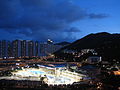 Tseung Kwan O Library at Dusk
 -
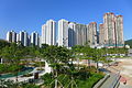 High density buildings in Hang Hau
 -
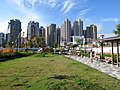
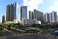 Tseung Kwan O Town Centre
 -
 Tseung Kwan O Village
 -
 Po Lam Estate
 -
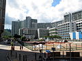
 Tseung Kwan O South
 -
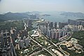 Above Tseung Kwan O


See also
References
- ^ "Archived copy". Archived from the original on 2007-02-11. Retrieved 2007-02-10.
{{cite web}}: Unknown parameter|deadurl=ignored (|url-status=suggested) (help)CS1 maint: archived copy as title (link) - ^ Waste management in Hong Kong
- ^ "Historical Background". www.pland.gov.hk.
- ^ "Geographical Location". www.pland.gov.hk.
- ^ "Monthly Means of Meteorological Elements for Tseung Kwan 0, 1992-2015". Hong Kong Observatory. Retrieved February 8, 2017.
- ^ "Planning Department – Tseung Kwan O". www.pland.gov.hk.
- ^ "Government Planned Development". www.pland.gov.hk.
- ^ "Tseung Kwan O." French International School of Hong Kong. Retrieved on February 10, 2017. "Area 67, Tseung Kwan O, Hong Kong"