
Spiez
Spiez | ||
|---|---|---|
 | ||
 Coat of arms | ||
Location of Spiez  | ||
Mayor Gemeindepräsident | Franz Arnold SPS/PSS (as of 2002) | |
| • Parliament | Grosser Gemeinderat with 36 members | |
| Area | ||
| • Total | 16.8 km2 (6.5 sq mi) | |
| Elevation (Railway station) | 628 m (2,060 ft) | |
| Population (31 December 2018)[2] | ||
| • Total | 12,810 | |
| • Density | 760/km2 (2,000/sq mi) | |
| Time zone | UTC+01:00 (Central European Time) | |
| • Summer (DST) | UTC+02:00 (Central European Summer Time) | |
| Postal code(s) | 3700 | |
| SFOS number | 0768 | |
| ISO 3166 code | CH-BE | |
| Localities | Einigen, Hondrich, Faulensee, and Spiezwiler | |
| Surrounded by | Aeschi bei Spiez, Hilterfingen, Krattigen, Oberhofen am Thunersee, Reutigen, Sigriswil, Thun, Wimmis, Zwieselberg | |
| Website | http://www.spiez.ch SFSO statistics | |
Spiez is a town and municipality on the shore of Lake Thun in the Bernese Oberland region of the Swiss canton of Bern. It is part of the Frutigen-Niedersimmental administrative district. Besides the town of Spiez, the municipality also includes the settlements of Einigen, Hondrich, Faulensee, and Spiezwiler.
The official language of Spiez is (the Swiss variety of Standard)
History
Spiez is first mentioned around 761-62 as Spiets.[3]
The area between the
During the
The former Church of St. Laurentius, next to the castle, was first mentioned in 761–62, when the

The castle and surrounding land remained with the Bubenberg family until their extinction in 1506, when it was acquired by Ludwig von Diesbach. Von Diesbach held it for ten years before Ludwig von Erlach acquired the castle and lands. The von Erlach family ruled the town and villages until the 1798 French invasion.[3]
The

Historically the residents of Spiez and the surrounding villages raised orchards and vineyards on along the lake, fished in the lake and shipped goods along the lake or raised crops in the valleys. The vineyards of Spiez were first mentioned in 1338 and remained in operation until an outbreak of disease destroyed the plants in 1900. An attempt in 1927 to restart the wine industry on Spiez mountain and at Faulensee was fairly successful. The villages along the Kander were often threatened by flooding, until the Kander was diverted into the lake in 1711–13. The construction of the Lake Thun road in 1844 and steam ship docks in 1835, 1876 and 1926 helped open the town to the rest of the country. Due to the mild climate and transportation links, Spiez became a popular health and spa town in the 19th century. Beginning in 1856 resorts and hotels, including the Schonegg, Spiezerhof and Faulensee-Bad, opened along the lake shore. The Thun-Spiez-Interlaken (1893), Spiez-Zweisimmen-Montreux (1897-1905) and Spiez-Frutigen-Lötschberg-Simplon (1901–13) railroads all helped the tourist industry and the rest of the town to grow. The growing population led to the construction of a secondary school and seven primary schools around the municipality. In the 1980s the A6 and A8 motorways further connected Spiez and the surrounding villages. In 1990 the Kander Tunnel opened, which helped reduce noise and pollution in the municipality.[3]
Geography

Spiez is located on the south shore of Lake Thun, stretching along a ridge that separates the lake front from the Kander that runs parallel and to the south. From its lowest point on the lake, at 558 m (1,831 ft) above sea level, it reaches a height of 852 m (2,795 ft) on the ridge at Hondrichhügel.
The municipality comprises five villages (
During the same year, industrial buildings made up 2.6% of the total area while housing and buildings made up 17.3% and transportation infrastructure made up 9.5%. while parks, green belts and sports fields made up 1.4%. A total of 28.8% of the total land area is heavily forested and 1.1% is covered with orchards or small clusters of trees. Of the agricultural land, 5.5% is used for growing crops and 28.0% is pasturage, while 2.6% is used for orchards or vine crops. Of the water in the municipality, 1.0% is in lakes and 1.0% is in rivers and streams.[5]
On 31 December 2009 Amtsbezirk Niedersimmental, the municipality's former district, was dissolved. On the following day, 1 January 2010, it joined the newly created Verwaltungskreis Frutigen-Niedersimmental.[6]
Coat of arms
The blazon of the municipal coat of arms is Argent three Piles Azure issuing from the base.[7]
Demographics

Spiez has a population (as of December 2020[update]) of 12,926.[8] As of 2010[update], 8.4% of the population are resident foreign nationals. Over the last 10 years (2001-2011) the population has changed at a rate of -0.5%. Migration accounted for -0.7%, while births and deaths accounted for 0%.[9]
Most of the population (as of 2000[update]) speaks German (11,302 or 94.0%) as their first language, Serbo-Croatian is the second most common (135 or 1.1%) and French is the third (101 or 0.8%). There are 100 people who speak Italian and 5 people who speak Romansh.[10]
As of 2008[update], the population was 48.5% male and 51.5% female. The population was made up of 5,521 Swiss men (44.3% of the population) and 533 (4.3%) non-Swiss men. There were 5,905 Swiss women (47.3%) and 516 (4.1%) non-Swiss women.[11] Of the population in the municipality, 3,135 or about 26.1% were born in Spiez and lived there in 2000. There were 5,220 or 43.4% who were born in the same canton, while 2,014 or 16.7% were born somewhere else in Switzerland, and 1,198 or 10.0% were born outside of Switzerland.[10]
As of 2011[update], children and teenagers (0–19 years old) make up 18.8% of the population, while adults (20–64 years old) make up 59.2% and seniors (over 64 years old) make up 22%.[9]
As of 2000[update], there were 4,678 people who were single and never married in the municipality. There were 5,862 married individuals, 840 widows or widowers and 647 individuals who are divorced.[10]
As of 2010[update], there were 1,924 households that consist of only one person and 275 households with five or more people.[12] In 2000[update], a total of 5,109 apartments (83.7% of the total) were permanently occupied, while 795 apartments (13.0%) were seasonally occupied and 200 apartments (3.3%) were empty.[13] As of 2010[update], the construction rate of new housing units was 2 new units per 1000 residents.[9] The vacancy rate for the municipality, in 2012[update], was 0.51%. In 2011, single family homes made up 52.3% of the total housing in the municipality.[14]
The historical population is given in the following chart:[3][15][16]

Sights
The medieval castle in the town dates from the 15th and 16th Centuries. Visitors can visit the grand halls within the castle, including the Baroque banquet hall built in 1614.
The Hotel Belvédère in Spiez accommodated the Germany national football team during the 1954 FIFA World Cup held in Switzerland. "The Spirit of Spiez", developed there among the players, is regarded as important factor that helped the German team to win the world championship.[citation needed]
Heritage sites of national significance
The Bürg archeological site with prehistoric and medieval settlement ruins, the
-
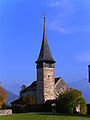 Swiss Reformed Castle Church
 -
 Weinbauernhof
 -
 Spiez Castle. Parts of the central tower were built around 933
 -
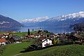 Faulensee village in Spiez municipality
 -
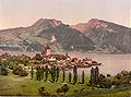 Spiez harbour and Lake Thun (ca. 1900)


Politics
In the
Economy
As of 2011[update], Spiez had an unemployment rate of 1.37%. As of 2008[update], there were a total of 4,649 people employed in the municipality. Of these, there were 155 people employed in the primary economic sector and about 48 businesses involved in this sector. 1,220 people were employed in the secondary sector and there were 95 businesses in this sector. 3,274 people were employed in the tertiary sector, with 399 businesses in this sector.[9] There were 5,928 residents of the municipality who were employed in some capacity, of which females made up 43.3% of the workforce.
In 2008[update] there were a total of 3,768 full-time equivalent jobs. The number of jobs in the primary sector was 92, of which 87 were in agriculture, 3 were in forestry or lumber production and 2 were in fishing or fisheries. The number of jobs in the secondary sector was 1,148 of which 657 or (57.2%) were in manufacturing, 3 or (0.3%) were in mining and 357 (31.1%) were in construction. The number of jobs in the tertiary sector was 2,528. In the tertiary sector; 411 or 16.3% were in wholesale or retail sales or the repair of motor vehicles, 283 or 11.2% were in the movement and storage of goods, 376 or 14.9% were in a hotel or restaurant, 32 or 1.3% were in the information industry, 85 or 3.4% were the insurance or financial industry, 196 or 7.8% were technical professionals or scientists, 163 or 6.4% were in education and 487 or 19.3% were in health care.[19]
In 2000[update], there were 2,387 workers who commuted into the municipality and 3,399 workers who commuted away. The municipality is a net exporter of workers, with about 1.4 workers leaving the municipality for every one entering. A total of 2,529 workers (51.4% of the 4,916 total workers in the municipality) both lived and worked in Spiez.[20] Of the working population, 23% used public transportation to get to work, and 47.2% used a private car.[9]
In 2011 the average local and cantonal tax rate on a married resident, with two children, of Spiez making 150,000 CHF was 12.4%, while an unmarried resident's rate was 18.3%.[21] For comparison, the average rate for the entire canton in the same year, was 14.2% and 22.0%, while the nationwide average was 12.3% and 21.1% respectively.[22] In 2009 there were a total of 5,701 tax payers in the municipality. Of that total, 1,986 made over 75,000 CHF per year. There were 39 people who made between 15,000 and 20,000 per year. The average income of the over 75,000 CHF group in Spiez was 114,437 CHF, while the average across all of Switzerland was 130,478 CHF.[23]
In 2011 a total of 4.0% of the population received direct financial assistance from the government.[24]
Religion

From the 2000 census[update], 8,504 or 70.7% belonged to the
Education
In Spiez about 58.7% of the population have completed non-mandatory upper secondary education, and 19.2% have completed additional higher education (either a university or a Fachhochschule).[9] Of the 1,474 who had completed some form of tertiary schooling listed in the census, 70.9% were Swiss men, 21.3% were Swiss women, 5.4% were non-Swiss men, and 2.4% were non-Swiss women.[10]
The canton of Bern school system provides one year of non-obligatory kindergarten, followed by six years of primary school. This is followed by three years of obligatory lower secondary school, where the students are separated according to ability and aptitude. Following the lower secondary, students may attend additional schooling, or they may enter an apprenticeship.[25]
During the 2011–12 school year, there were a total of 1,286 students attending classes in Spiez. There were 9 kindergarten classes with a total of 182 students in the municipality. Of the kindergarten students, 8.2% were permanent or temporary residents of Switzerland (not citizens), and 12.6% have a different mother language than the classroom language. The municipality had 35 primary classes and 630 students. Of the primary students, 9.4% were permanent or temporary residents of Switzerland (not citizens), and 13.7% have a different mother language than the classroom language. During the same year, there were 22 lower secondary classes with a total of 444 students. There were 9.0% who were permanent or temporary residents of Switzerland (not citizens), and 13.3% have a different mother language than the classroom language. The remainder of the students attend a private or special school.[26]
As of 2000[update], there were a total of 1,779 students attending any school in the municipality. Of those, 1,291 both lived and attended school in the municipality, while 488 students came from another municipality. During the same year, 229 residents attended schools outside the municipality.[20]
Spiez is home to a regional library which has (as of 2008[update]) 20,276 books or other media, and loaned out 135,277 items in the same year. It was open a total of 304 days, with an average of 30 hours per week during that year.[27]
Crime
In 2014 the crime rate, of the over 200 crimes listed in the
Transport

The municipality of Spiez is served by the
Notable people
- anthroposophist, born and died in Spiez.
- Maya Pedersen-Bieri (born 1972 in Spiez) a Swiss-Norwegian skeleton racer, won the gold medal in the women's skeleton event at the 2006 Winter Olympics
- Caroline Steffen (born 1978 in Spiez) a professional triathlete
See also
References
- ^ a b "Arealstatistik Standard - Gemeinden nach 4 Hauptbereichen". Federal Statistical Office. Retrieved 13 January 2019.
- ^ "Ständige Wohnbevölkerung nach Staatsangehörigkeitskategorie Geschlecht und Gemeinde; Provisorische Jahresergebnisse; 2018". Federal Statistical Office. 9 April 2019. Retrieved 11 April 2019.
- ^ a b c d e f g h Spiez in German, French and Italian in the online Historical Dictionary of Switzerland.
- ^ Arealstatistik Standard - Gemeindedaten nach 4 Hauptbereichen
- ^ a b Swiss Federal Statistical Office-Land Use Statistics 2009 data (in German) accessed 25 March 2010
- ^ Nomenklaturen – Amtliches Gemeindeverzeichnis der Schweiz Archived 2015-11-13 at the Wayback Machine (in German) accessed 4 April 2011
- ^ Flags of the World.com accessed 22 November 2013
- ^ "Ständige und nichtständige Wohnbevölkerung nach institutionellen Gliederungen, Geburtsort und Staatsangehörigkeit". bfs.admin.ch (in German). Swiss Federal Statistical Office - STAT-TAB. 31 December 2020. Retrieved 21 September 2021.
- ^ a b c d e f Swiss Federal Statistical Office accessed 22 November 2013
- ^ a b c d e STAT-TAB Datenwürfel für Thema 40.3 - 2000 Archived 2014-04-09 at the Wayback Machine (in German) accessed 2 February 2011
- ^ Statistical office of the Canton of Bern (in German) accessed 4 January 2012
- ^ Swiss Federal Statistical Office - Haushaltsgrösse Archived 2014-10-06 at the Wayback Machine (in German) accessed 8 May 2013
- ^ Swiss Federal Statistical Office STAT-TAB - Datenwürfel für Thema 09.2 - Gebäude und Wohnungen Archived 2014-09-07 at the Wayback Machine (in German) accessed 28 January 2011
- ^ Statistischer Atlas der Schweiz - Anteil Einfamilienhäuser am gesamten Gebäudebestand, 2011 accessed 17 June 2013
- ^ Swiss Federal Statistical Office STAT-TAB Bevölkerungsentwicklung nach Region, 1850-2000 Archived 2014-09-30 at the Wayback Machine (in German) accessed 29 January 2011
- ^ Swiss Federal Statistical Office - Ständige Wohnbevölkerung in Privathaushalten nach Gemeinde und Haushaltsgrösse Archived 2014-07-18 at the Wayback Machine (in German) accessed 12 August 2013
- ^ "Kantonsliste A-Objekte". KGS Inventar (in German). Federal Office of Civil Protection. 2009. Archived from the original on 28 June 2010. Retrieved 25 April 2011.
- ^ Swiss Federal Statistical Office 2011 Election Archived 2013-11-14 at the Wayback Machine (in German) accessed 8 May 2012
- ^ Swiss Federal Statistical Office STAT-TAB Betriebszählung: Arbeitsstätten nach Gemeinde und NOGA 2008 (Abschnitte), Sektoren 1-3 Archived 2014-12-25 at the Wayback Machine (in German) accessed 28 January 2011
- ^ a b Swiss Federal Statistical Office - Statweb Archived 2012-08-04 at archive.today (in German) accessed 24 June 2010
- ^ Statistischer Atlas der Schweiz - Steuerbelastung, 2011 Politische Gemeinden (in German) accessed 15 May 2013
- ^ Swiss Federal Tax Administration - Grafische Darstellung der Steuerbelastung 2011 in den Kantonen (in German and French) accessed 17 June 2013
- ^ Federal Tax Administration Report Direkte Bundessteuer - Natürliche Personen - Gemeinden - Steuerjahr 2009 Archived 2014-10-06 at the Wayback Machine (in German and French) accessed 15 May 2013
- ^ Statistischer Atlas der Schweiz - Bezüger/-innen von Sozialhilfeleistungen (Sozialhilfeempfänger/-innen), 2011 accessed 18 June 2013
- ^ EDK/CDIP/IDES (2010). Kantonale Schulstrukturen in der Schweiz und im Fürstentum Liechtenstein / Structures Scolaires Cantonales en Suisse et Dans la Principauté du Liechtenstein (PDF) (Report). Retrieved 24 June 2010.
- ^ Schuljahr 2011/12 pdf document(in German) accessed 9 May 2013
- ^ Swiss Federal Statistical Office, list of libraries Archived 2015-07-06 at the Wayback Machine (in German) accessed 14 May 2010
- ^ Statistical Atlas of Switzerland accessed 5 April 2016
External links
 Spiez travel guide from Wikivoyage
- Official web page of the municipality Spiez
- SPIEZ LABORATORY, the Swiss NBC-defence institute
- Spiez: Map and Photos
Municipalities in the Frutigen-Niedersimmental administrative district, Switzerland | ||
|---|---|---|
| International | |
|---|---|
| National | |
| Geographic | |
| Other | |