
St. Augustine, Florida
St. Augustine
San Agustín ( City | ||
|---|---|---|
| City of St. Augustine | ||
 Top, left to right: Castillo de San Marcos, St. Augustine Light, Flagler College, Lightner Museum, statue near the Cathedral Basilica of St. Augustine, St. Augustine Alligator Farm Zoological Park, Old St. Johns County Jail | ||
|
FIPS code 12-62500[4] | | |
| GNIS feature ID | 0308101[3] | |
| Website | City of St. Augustine | |
St. Augustine (/ˈɔːɡəstiːn/ AW-gə-steen; Spanish: San Agustín [san aɣusˈtin]) is a city in and the county seat of St. Johns County located 40 miles (64 km) south of downtown Jacksonville. The city is on the Atlantic coast of northeastern Florida. Founded in 1565 by Spanish explorers, it is the oldest continuously inhabited European-established settlement in what is now the contiguous United States.
St. Augustine was founded on September 8, 1565, by Spanish admiral
Spain ceded Florida to the United States in 1819, and St. Augustine was designated one of the two alternating capitals of the Florida Territory, the other being Pensacola, upon ratification of the Adams–Onís Treaty in 1821. The Florida National Guard made the city its headquarters that same year. The territorial government moved and made Tallahassee the permanent capital of Florida in 1824.[6]
St. Augustine is part of Florida's First Coast region and the Jacksonville metropolitan area. Since the late 19th century, St. Augustine's distinctive historical character has made the city a tourist attraction. Castillo de San Marcos, the city's 17th-century Spanish fort—constructed out of the sedimentary rock coquina—continues to attract tourists.[7]
History
Spanish Empire 1565–1763
Kingdom of Great Britain 1763–1784
Spanish Empire 1784–1821
United States 1821–1861
Confederate States 1861–1862
United States 1862–present

Early exploration
The first European known to have explored the coasts of Florida was the Spanish explorer and governor of Puerto Rico, Juan Ponce de León, who likely ventured in 1513 as far north as the vicinity of the future St. Augustine, naming the peninsula he believed to be an island "La Florida" and claiming it for the Spanish crown.[8][9]
Founding by Pedro Menéndez de Avilés
Founded in 1565 by the Spanish conquistador Pedro Menéndez de Avilés, St. Augustine is the oldest continuously occupied settlement of European origin in the contiguous United States.[10][11] It is the second-oldest continuously inhabited city of European origin in a United States territory, after San Juan, Puerto Rico (founded in 1521).[12]
In
In early 1564, he asked permission to go to Florida to search for La Concepcion, the galeon Capitana, or flagship, of the New Spain fleet commanded by his son, Admiral Juan Menéndez. The ship had been lost in September 1563 when a hurricane scattered the fleet as it was returning to Spain, at the latitude of Bermuda off the coast of South Carolina.[14] The crown repeatedly refused his request.
The crown eventually approached Menéndez to fit out an expedition to Florida
Menéndez was in a race to reach Florida before the French captain
The mission served nearby villages of the Mocama, a Timucua group, and was at the center of an important chiefdom in the late 16th and 17th century. The settlement was built in the former Timucua village of Seloy; this site was chosen for its strategic location facing the waterways of St. Augustine bay with their abundant resources, an eminently suitable site for water communications and defense.[25]
A French attack on St. Augustine was thwarted by a violent squall that ravaged the French naval forces. Taking advantage of this, Menéndez marched his troops overland to Fort Caroline on the
Invasions by pirates and enemies of Spain
Succeeding governors of the province maintained a peaceful coexistence with the local Native Americans, allowing the isolated outpost of St. Augustine some stability for a few years. On May 28 and 29, 1586, soon after the Anglo-Spanish War began between England and Spain, the English privateer Sir Francis Drake sacked and burned St. Augustine.[29] The approach of his large fleet obliged Governor Pedro Menéndez Márquez and the townspeople to evacuate the settlement. When the English got ashore, they seized some artillery pieces and a royal strongbox containing gold ducats (which was the garrison payroll).[30] The killing of their sergeant major by the Spanish rearguard caused Drake to order the town razed to the ground.[31][32]
In 1609 and 1611, expeditions were sent out from St. Augustine against the English colony at Jamestown.[33] In the second half of the 17th century, groups of Indians from the colony of Carolina conducted raids into Florida and killed the Franciscan priests who served at the Catholic missions. Requests by successive governors of the province to strengthen the presidio's garrison and fortifications were ignored by the Spanish Crown which had other priorities in its vast empire. The charter of 1663 for the new Province of Carolina, issued by King Charles II of England, was revised in 1665, claiming lands as far southward as 29 degrees north latitude, about 65 miles south of the existing settlement at St. Augustine.[34][35][36]
The English buccaneer Robert Searle sacked St. Augustine in 1668, after capturing some Spanish supply vessels bound for the settlement and holding their crews at gun point while his men hid below decks. Searle was retaliating for the Spanish destruction of the settlement of New Providence in the Bahamas. Searle and his men killed sixty people and pillaged public storehouses, churches and houses.[37] This raid and the establishment of the English settlement at Charles Town spurred the Spanish Crown to finally acknowledge the vulnerability of St. Augustine to foreign incursions and strengthen the city's defenses. In 1669, Queen Regent Mariana ordered the Viceroy of New Spain to disburse funds for the construction of a permanent masonry fortress, which began in 1672.[38] Before the fortress was completed, French buccaneers Michel de Grammont and Nicolas Brigaut planned an ill-fated attack in 1686 which was foiled: their ships were run aground, Grammont and his crew were lost at sea, and Brigaut was captured ashore by Spanish soldiers.[39] The Castillo de San Marcos was completed in 1695, not long before an attack by James Moore's forces from Carolina in November, 1702. Failing to capture the fort after a siege of 58 days, the British set St. Augustine ablaze as they retreated.[40]
In 1738, the governor of Spanish Florida,
In 1740, however, St. Augustine was again besieged, this time by the governor of the British colony of Georgia, General James Oglethorpe, who was also unable to take the fort.[43]
Loyalist haven under British rule
The 1763 Treaty of Paris, signed after Great Britain's victory over France and Spain during the Seven Years' War, ceded Florida to Great Britain in exchange for the return of Havana and Manila. The vast majority of Spanish colonists in the region left Florida for Cuba, Florida became Great Britain's fourteenth and fifteenth North American colonies, and because of the political sympathies of its British inhabitants, St. Augustine became a Loyalist haven during the American Revolutionary War.[44]
After the mass exodus of St. Augustinians, Great Britain sought to repopulate its new colony. The London Board of Trade advertised 20,000-acre lots to any group that would settle in Florida within ten years, with one resident per 100 acres. Pioneers who were "energetic and of good character" were given 100 acres of land and 50 additional acres for each family member they brought. Under Governor James Grant, almost three million acres of land were granted in East Florida alone. Second stories were added to existing Spanish homes and new houses were built. Cattle ranching and plantation agriculture began to thrive.[45]
During the twenty-year period of British rule, Britain took command of both the Castillo de San Marcos (renamed Fort St. Mark) and of
The
Second Spanish period
During the Second Spanish period (1784–1821) of Florida, Spain was dealing with invasions of the Iberian peninsula by Napoleon's armies in the Peninsular War, and struggled to maintain a tenuous hold on its territories in the western hemisphere as revolution swept South America. The royal administration of Florida was neglected, as the province had long been regarded as an unprofitable backwater by the Crown. The United States, however, considered Florida vital to its political and military interests as it expanded its territory in North America, and maneuvered by sometimes clandestine means to acquire it.[49] On October 5, 1811, a hurricane hit St. Augustine that caused extensive damage to the city. The damage was further exacerbated by the economic situation of Spanish Florida.[50] The Adams–Onís Treaty, negotiated in 1819 and ratified in 1821, ceded Florida and St. Augustine, still its capital at the time, to the United States.[51]
Territory of Florida
According to the Adams–Onís Treaty, the United States acquired East Florida and absolved Spain of $5 million of debt. Spain renounced all claims to West Florida and the Oregon Country. Andrew Jackson returned to Florida in 1821, upon ratification of the treaty, and established a new territorial government. Americans from older plantation societies of Virginia, Georgia, and the Carolinas began to move to the area. West Florida was quickly consolidated with East and the new capital of Florida became Tallahassee, halfway between the old capitals of St. Augustine and Pensacola, in 1824.[52]
Once many Americans had begun to immigrate to the new territory, it became apparent that there would be continued skirmishes with local Creek and Miccosukee peoples and white settlers encroaching on their land. The United States government favored removal policies, but local indigenous groups in Florida refused to leave without fighting. The nineteenth century saw three Seminole Wars. In 1823, territorial governor William Duval and James Gadsden signed the Treaty of Moultrie Creek, forcing Seminoles onto a four million acre reservation in central Florida. The Second Seminole War (1835–1842) was the longest war of Indian removal and resulted when the United States government attempted to move the Seminole people from Central Florida to a Creek reservation west of the Mississippi River. As a result of the Seminole War, Seminole prisoners, including the prominent leader Osceola, were held captive in the Castillo de San Marcos, renamed Fort Marion after General Francis Marion, who fought in the American Revolution, in the 1830s.[52][53][54]
By 1840, the territory's population had reached 54,477 people. Half the population were enslaved Africans. Steamboats were popular on the Apalachicola and St. Johns Rivers, and there were several plans for railroad construction. The territory south of present-day Gainesville was sparsely populated by whites.[52]
In 1845 the Florida Territory was admitted into the Union as the State of Florida.[55]
Civil War
_(cropped).jpg)
On January 7, 1861, only three days before Florida would secede and join the Confederacy, a group of 125 Florida militia marched on Fort Marion. The fort was guarded by a single sergeant, who surrendered the fort after being provided with a receipt. Gen. Robert E. Lee, who was commander of coastal defenses at the time, ordered that the fort's cannons be removed and sent to more strategic locations, such as Fernandina and the mouth of the St. Johns River.[56]
The town raised a Confederate militia unit, known as the Florida Independent Blues or the Saint Augustine Blues.[57] They were soon joined by the Milton Guard, another militia unit.[58]
In an effort to help blockade runners avoid capture, the Confederate government ordered all lighthouses to be extinguished. In St. Augustine, the customhouse officer, Paul Arnau, organized the "Coastal Guard", a group who worked to disable the lighthouses along Florida's east coast. They started by removing and hiding the lenses from the St. Augustine Light before moving south. After successfully dismantling the lighthouses at Cape Canaveral, Jupiter Inlet, and Key Biscayne, Arnau returned to St. Augustine. He would then serve as mayor from 1861 until early 1862, just before the Federals took over the city.[59]
The Confederate authorities remained in control of St. Augustine for fourteen months, although it was barely defended. The Union conducted a blockade of shipping. In 1862 Union troops gained control of St. Augustine and controlled it through the rest of the war. With the economy already suffering, many residents fled.[60][61]
Henry Flagler and the railroad
.jpg)
Flagler finished construction in 1887 on two large ornate hotels in the city, the 450-room
When Flagler's
Civil Rights Movement
In 1963, nearly a decade after the Supreme Court ruling in
In the spring of 1964, St. Augustine civil rights leader Robert Hayling[72] asked the Southern Christian Leadership Conference (SCLC) and its leader Martin Luther King Jr. for assistance.[73] From May until July 1964, King and Hayling, along with Hosea Williams, C. T. Vivian, Dorothy Cotton, Andrew Young and others, organized marches, sit-ins, pray-ins, wade-ins and other forms of protest in St. Augustine. Hundreds of black and white civil rights supporters were arrested,[74] and the jails were filled to capacity.[75] At the request of Hayling and King, civil rights supporters from elsewhere, including students, clergy, activists and well-known public figures, came to St. Augustine and were arrested together.[76][77][78]
St. Augustine was the only place in Florida where King was arrested; his arrest there occurred on June 11, 1964, on the steps of the
The Ku Klux Klan and its supporters responded to these protests with violent attacks that were widely reported in national and international media.[79] Popular revulsion against the Klan and police violence in St. Augustine generated national sympathy for the black protesters and became a key factor in Congressional passage of the Civil Rights Act of 1964,[80] leading eventually to passage of the Voting Rights Act of 1965,[81] both of which provided federal enforcement of constitutional rights.
St. Augustine's historically Black college, now
Modern St. Augustine
In 1965, St. Augustine celebrated the 400th anniversary of its founding,[83] and jointly with the State of Florida, inaugurated a program to restore part of the colonial city. The Historic St. Augustine Preservation Board was formed to reconstruct more than thirty-six buildings to their historical appearance, which was completed within a few years. When the State of Florida abolished the Board in 1997, the City of St. Augustine assumed control of the reconstructed buildings, as well as other historic properties including the Government House. In 2010, the city transferred control of the historic buildings to UF Historic St. Augustine, Inc., a direct support organization of the University of Florida.
Cross and Sword was a 1965 play by American playwright Paul Green created to honor the 400th anniversary of the settlement of St. Augustine. It was Florida's official state play, having received the designation by the Florida Senate in 1973.[84] It was performed for ten weeks every summer in St. Augustine for more than 30 years, closing in 1996.[85] [86][87][88]
In 2015, St. Augustine celebrated the 450th anniversary of its founding with a four-day long festival and a visit from
On October 7, 2016 Hurricane Matthew caused widespread flooding in downtown St. Augustine.[90]
Geography and climate

St. Augustine is located at 29°53′41″N 81°18′52″W / 29.89472°N 81.31444°W (29.8946910, −81.3145170). According to the United States Census Bureau, the city has a total area of 10.7 square miles (27.8 km2), 8.4 square miles (21.7 km2) of which is land and 2.4 square miles (6.1 km2) (21.99%) is water. Access to the Atlantic Ocean is via the St. Augustine Inlet of the Matanzas River.
St. Augustine has a humid subtropical climate (Cfa) typical of the Gulf and South Atlantic states. The low latitude and coastal location give the city a mostly warm and sunny climate. Unlike much of the contiguous United States, St. Augustine's driest time of year is winter. The hot and wet season extends from May through October, while the cool and dry season extends November through April.
In summer, average high temperatures are in the lower 90's F (32 C) and normal low temperatures are in the 70's F (20 - 22 C). The Bermuda High pumps in hot and unstable tropical air from the Bahamas and Gulf of Mexico, which help create the daily thundershowers that are typical in summer months. Intense but very brief downpours are common in summer in the city. Fall and spring are warm and sunny with highs from 74 °F to 87 °F and lows in the 50s to 70s.
In winter, St. Augustine has generally mild and sunny weather typical of the Florida peninsula. The coolest months are from December through February, with highs from 67 °F to 70 °F and lows from 47 °F to 51 °F. From November through April, St. Augustine often has long periods of rainless weather. April can see near drought conditions with brush fires and water restrictions in place. St. Augustine averages 4.6 frosts per year. The record low of 10 °F (−12 °C) happened on January 21, 1985.
| Climate data for St. Augustine, Florida (St. Augustine Light), 1991–2020 normals, extremes 1973–2016 | |||||||||||||
|---|---|---|---|---|---|---|---|---|---|---|---|---|---|
| Month | Jan | Feb | Mar | Apr | May | Jun | Jul | Aug | Sep | Oct | Nov | Dec | Year |
| Record high °F (°C) | 86 (30) |
87 (31) |
93 (34) |
95 (35) |
98 (37) |
101 (38) |
103 (39) |
101 (38) |
99 (37) |
94 (34) |
89 (32) |
86 (30) |
103 (39) |
| Mean maximum °F (°C) | 80.0 (26.7) |
81.8 (27.7) |
84.9 (29.4) |
88.6 (31.4) |
93.3 (34.1) |
95.9 (35.5) |
97.6 (36.4) |
96.0 (35.6) |
92.8 (33.8) |
89.0 (31.7) |
84.2 (29.0) |
81.1 (27.3) |
98.5 (36.9) |
| Mean daily maximum °F (°C) | 67.5 (19.7) |
69.7 (20.9) |
74.4 (23.6) |
79.8 (26.6) |
85.1 (29.5) |
88.6 (31.4) |
91.0 (32.8) |
89.9 (32.2) |
87.4 (30.8) |
81.8 (27.7) |
74.9 (23.8) |
68.9 (20.5) |
79.9 (26.6) |
| Daily mean °F (°C) | 57.6 (14.2) |
60.0 (15.6) |
64.5 (18.1) |
70.2 (21.2) |
76.3 (24.6) |
80.4 (26.9) |
82.4 (28.0) |
82.1 (27.8) |
80.3 (26.8) |
74.2 (23.4) |
66.2 (19.0) |
60.1 (15.6) |
71.2 (21.8) |
| Mean daily minimum °F (°C) | 47.8 (8.8) |
50.2 (10.1) |
54.6 (12.6) |
60.6 (15.9) |
67.4 (19.7) |
72.3 (22.4) |
73.8 (23.2) |
74.2 (23.4) |
73.1 (22.8) |
66.5 (19.2) |
57.5 (14.2) |
51.3 (10.7) |
62.4 (16.9) |
| Mean minimum °F (°C) | 28.1 (−2.2) |
32.1 (0.1) |
36.9 (2.7) |
44.6 (7.0) |
55.6 (13.1) |
64.8 (18.2) |
68.1 (20.1) |
68.6 (20.3) |
64.0 (17.8) |
49.0 (9.4) |
39.1 (3.9) |
31.4 (−0.3) |
25.6 (−3.6) |
| Record low °F (°C) | 10 (−12) |
21 (−6) |
23 (−5) |
34 (1) |
41 (5) |
52 (11) |
59 (15) |
61 (16) |
54 (12) |
36 (2) |
29 (−2) |
16 (−9) |
10 (−12) |
| Average precipitation inches (mm) | 2.74 (70) |
2.69 (68) |
3.43 (87) |
2.93 (74) |
3.66 (93) |
6.27 (159) |
4.88 (124) |
7.18 (182) |
7.18 (182) |
4.37 (111) |
2.32 (59) |
2.99 (76) |
50.64 (1,286) |
| Average precipitation days (≥ 0.01 in) | 9.4 | 7.8 | 8.6 | 6.8 | 7.2 | 12.3 | 11.6 | 15.0 | 13.5 | 9.1 | 8.1 | 8.4 | 117.8 |
| Source: NOAA (mean maxima/minima 1981–2010)[92][93] | |||||||||||||
Demographics
| Census | Pop. | Note | %± |
|---|---|---|---|
| 1830 | 1,708 | — | |
| 1840 | 2,450 | 43.4% | |
| 1850 | 1,934 | −21.1% | |
| 1860 | 1,914 | −1.0% | |
| 1870 | 1,717 | −10.3% | |
| 1880 | 2,293 | 33.5% | |
| 1890 | 4,742 | 106.8% | |
| 1900 | 4,272 | −9.9% | |
| 1910 | 5,494 | 28.6% | |
| 1920 | 6,192 | 12.7% | |
| 1930 | 12,111 | 95.6% | |
| 1940 | 12,090 | −0.2% | |
| 1950 | 13,555 | 12.1% | |
| 1960 | 14,734 | 8.7% | |
| 1970 | 12,352 | −16.2% | |
| 1980 | 11,985 | −3.0% | |
| 1990 | 11,692 | −2.4% | |
| 2000 | 11,592 | −0.9% | |
| 2010 | 12,975 | 11.9% | |
| 2020 | 14,329 | 10.4% | |
| U.S. Decennial Census[94] | |||
| Race | Pop 2010[95] | Pop 2020[96] | % 2010 | % 2020 |
|---|---|---|---|---|
White (NH)
|
10,443 | 11,275 | 80.49% | 78.69% |
Black or African American (NH)
|
1,460 | 1,136 | 11.25% | 7.93% |
Alaska Native (NH)
|
46 | 40 | 0.35% | 0.28% |
| Asian (NH) | 155 | 246 | 1.19% | 1.72% |
Native Hawaiian (NH)
|
10 | 7 | 0.08% | 0.05% |
Some other race (NH)
|
19 | 53 | 0.15% | 0.37% |
| Two or more races/Multiracial (NH) | 186 | 523 | 1.43% | 3.65% |
| Hispanic or Latino (any race) | 656 | 1,049 | 5.06% | 7.32% |
| Total | 12,975 | 14,329 |
As of the 2020 United States census, there were 14,329 people, 5,828 households, and 3,072 families residing in the city.[97]
In 2020, 2.2% of the population were under 5 years old, 8.7% under 18 years old, and 25.5% were 65 years and over. 57.9% of the population were female.[98]
In 2020, the median value of owner-occupied housing units was $294,600. The median gross rent was $1,118. 91.2% of households had a computer and 83.0% of households had a broadband internet subscription.[98]
In 2020, 93.8% of the population 25 years and older had a high school degree or higher and 37.4% of that same population had a bachelor's degree or higher.[98]
In 2020, the median household income was $60,455. The per capita income was $33,060. 17.0% lived below the Poverty threshold.[98]
There were 1,230 veterans living in the city between 2016 and 2020, and 6.6% of the population were foreign born persons.[98]
As of the 2010 United States census, there were 12,975 people, 5,494 households, and 2,546 families residing in the city.[99]
Government and politics
St. Augustine is the county seat of St. Johns County, Florida.[100][101]
The city of St. Augustine operates under a
Transportation
Highways

 Interstate 95 runs north–south.
 U.S. Route 1 runs north–south.
 State Road A1A runs north–south.
 State Road 16 runs east–west
 State Road 207 runs northeast–southwest
 State Road 312 runs east–west
Buses
Bus service is operated by the Sunshine Bus Company, based in
Airport
St. Augustine has one public airport 4 miles (6.4 km) north of the downtown. It has three runways and two seaplane lanes.[104]
Rail
The
Points of interest
First and second Spanish eras
- Avero House
- Castillo de San Marcos National Monument
- Fort Matanzas National Monument
- Fort Mose Historic State Park
- Nombre de Dios
- Gonzalez-Alvarez House
- Fountain of Youth Archaeological Park
- The Spanish Military Hospital Museum
- St. Francis Barracks
- Colonial Quarter
- Ximenez-Fatio House
- González-Jones House
- Llambias House
- Oldest Wooden Schoolhouse
- Tolomato Cemetery and Huguenot Cemetery
British era
Pre-Flagler era
- St. Augustine Lighthouse and Museum
- Markland Mansion
Flagler era
- Ponce de Leon Hotel
- Casa Monica Hotel
- Hotel Alcazar
- Zorayda Castle
- Bridge of Lions
- Old St. Johns County Jail
- Ripley's Believe it or Not! Museum located in 1887 mansion of William Worden.
- St. Augustine Alligator Farm Zoological Park
Historic churches
- Grace United Methodist Church
- Cathedral Basilica of St. Augustine
- Memorial Presbyterian Church
- Trinity Church of St. Augustine
Lincolnville National Historic District – Civil Rights era
Other points of interest
- Anastasia State Park
- Florida School for the Deaf and Blind
- Great Cross
- St. Augustine Amphitheatre
- St. Augustine Aquarium
- St. Augustine Pirate & Treasure Museum
- Victory III, St. Augustine Scenic Cruise boat, since 1973
Culture
This section needs expansion. You can help by adding to it. (May 2023) |
Music
- The Wobbly Toms (2003), band
Education

Primary and secondary education in St. Augustine is overseen by the St. Johns County School District.
There are four zoned elementary schools with sections of the city limits in their attendance boundaries: John A. Crookshank (outside the city limits),[105] R. B. Hunt,[106] Ketterlinus,[107] and Osceola (outside the city limits).[108]
There are two zoned middle schools (both outside the city limits): R. J. Murray Middle School and GAmble Rodgers Middle SchoolCite error: There are <ref> tags on this page without content in them (see the
The
There are several institutions of higher education in and around St. Augustine.
The institution now known as
-
 St. Augustine High Schoolis not in the city limits, but is the zoned high school of St. Augustine
 -
 Ketterlinus Elementary School is one of two public elementary schools in the St. Augustine city limits.
 -
 Florida School for the Deaf and Blind is a statewide K-12 school for the deaf and blind in St. Augustine


Notable people


- Andrew Anderson, physician, St. Augustine mayor
- Steve Berry (novelist), bestselling author, resides in St. Augustine
- Jorge Biassou, Haitian revolutionary and black Spanish general
- Richard Boone, actor
- Albert Boyd, member of National Aviation Hall of Fame
- James Branch Cabell, novelist
- Doug Carn, jazz musician
- Cris Carpenter, major league baseball pitcher
- Ray Charles, pianist, singer, composer
- George J. F. Clarke, Surveyor General of Spanish East Florida
- Nicholas de Concepcion, escaped slave who became a Spanish privateer and pirate captain
- Earl Cunningham, artist
- Alexander Darnes, born a slave, became a well-known physician
- Edmund Jackson Davis, governor of Texas
- Kathleen Deagan, archaeologist
- Frederick Delius, composer
- Ulysses Grant
- Audrey Nell Edwards, civil rights hero
- Henry Flagler, industrialist
- Willie Galimore, football star
- Michael Gannon, historian
- William H. Gray, U.S. congressman and president of the United Negro College Fund
- Martin Davis Hardin, Union General in the Civil War
- Robert Hayling, civil rights leader
- Martin Johnson Heade, artist
- Zora Neale Hurston, novelist and folklorist
- Willie Irvin, Philadelphia Eagles football player
- Stetson Kennedy, author and human rights activist
- Scott Lagasse, race car driver
- Scott Lagasse Jr., race car driver
- Jacob Lawrence, artist
- William W. Loring, Confederate general
- Fulbright Scholar
- Howell W. Melton, United States district judge
- Prince Achille Murat, nephew of Napoleon Bonaparte
- Andrew Nagorski, journalist and author
- David Nolan, author and historian
- Fort Marion, now Castillo de San Marcos)
- Verle A. Pope, state legislator
- Richard Henry Pratt, soldier and educator
- Marjorie Kinnan Rawlings, novelist
- Marcus Roberts, musician
- Gamble Rogers, folk singer
- John M. Schofield, Union general
- Edmund Kirby Smith, Confederate general
- Bill Snowden, race car driver
- Steve Spurrier, college/pro (American) football coach
- Felix Varela, Cuban national hero
- Augustin Verot, first Bishop of St. Augustine
- Patty Wagstaff, member of National Aviation Hall of Fame
- DeWitt Webb, physician, St. Augustine mayor, state representative
- Levy County and Yulee, Floridanamesake
- Agustin V. Zamorano, pioneer printer and provisional governor of California
Sister cities
St. Augustine's
 Avilés, Spain
 Cartagena, Colombia
- Menorca, Spain
 Santo Domingo, Dominican Republic
Gallery
-
 Bell tower on northeast bastion of the Castillo de San Marcos
 -
 North bastions and wall of the Castillo, looking eastward toward Anastasia Island
 -
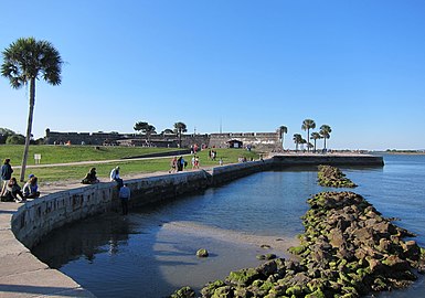 Seawall south of the Castillo
 -
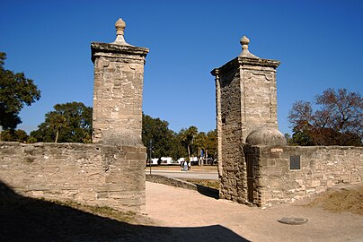 The city gates of St. Augustine, built in 1808, part of the much older Cubo Line
 -
![The Government House. East wing of the building dates to the 18th-century structure built on original site of the colonial governor's residence.[120]](//upload.wikimedia.org/wikipedia/commons/thumb/1/11/St_Aug_Govt_House_Museum01.jpg/360px-St_Aug_Govt_House_Museum01.jpg) The Government House. East wing of the building dates to the 18th-century structure built on original site of the colonial governor's residence.[120]
The Government House. East wing of the building dates to the 18th-century structure built on original site of the colonial governor's residence.[120] -
 Facade of the Roman CatholicCathedral of St. Augustine
 -
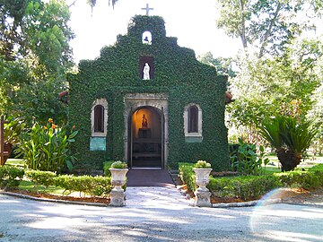 Shrine of Our Lady of La Leche at Mission Nombre de Dios
 -
 Statue of Ponce de León
 -

-
 The former Hotel Alcazar now houses the Lightner Museum and City Hall
 -
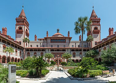 Flagler College, formerly the Ponce de Leon Hotel
 -
 Bridge of Lions, looking eastward to Anastasia Island
 -
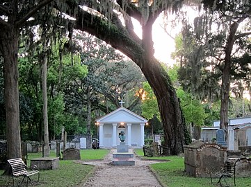 Tolomato Cemetery
.jpg)
.jpg)
.jpg)

![The Government House. East wing of the building dates to the 18th-century structure built on original site of the colonial governor's residence.[120]](/File:St_Aug_Govt_House_Museum01.jpg)


-Juan_Ponce_de_Leon_monument.jpg)


.jpg)
.jpg)
See also
- Gálveztown (brig sloop) – ship which played a role in the Gulf Coast campaign of the American Revolutionary War under Bernardo de Gálvez, and its replica built recently in Spain anticipating the 450th anniversary of St. Augustine's founding (1565–2015).
- St. Augustine movement
References
- ^ "GNIS Detail – Saint Augustine". geonames.usgs.gov. Geographic Names Information System. February 12, 2011. Retrieved April 23, 2011.
- ^ "2020 U.S. Gazetteer Files". United States Census Bureau. Retrieved October 31, 2021.
- ^ a b "US Board on Geographic Names". geonames.usgs.gov. United States Geological Survey. October 25, 2007. Archived from the original on February 12, 2012. Retrieved January 31, 2008.
- ^ "U.S. Census website". census.gov. United States Census Bureau. Retrieved January 31, 2008.
- ISBN 978-0-19-802036-3. Archivedfrom the original on May 3, 2016. Retrieved October 27, 2015.
- ISBN 978-0-226-08051-2.
- ^ Staff (April 10, 2020). "Coquina | The rock that saved St. Augustine)". www.nps.gov. Archived from the original on March 4, 2021. Retrieved December 6, 2022.
- ISBN 978-0-8173-5257-8.
- ISBN 978-1-4367-0883-8.
- ^ "Florida: St. Augustine Town Plan Historic District". nps.gov. National Park Service. Archived from the original on April 30, 2015. Retrieved May 27, 2015.
- ^ "Not So Fast, Jamestown: St. Augustine Was Here First". NPR. Archived from the original on November 5, 2019. Retrieved November 5, 2019.
- ISBN 978-1-62513-185-0.
- ^ Lowery, Woodbury (1911). The Spanish settlements within the present limits of the United States: Florida, 1562-1574. G.P. Putnam. p. 144.
- ^ Turner, Sam (July 18, 2015). "Menéndez anguishes in prison as son is lost at sea". Tallahassee Democrat. Archived from the original on January 31, 2016. Retrieved August 9, 2020.
- ISBN 978-0-7864-6221-6.
- ^ Lowery 1911, p.100
- ^ Lowery 1911, p.105
- ISBN 978-1-56164-003-4. Retrieved November 20, 2012.
- ISBN 978-0-8130-0777-9.
- ^ William S. Coker (1993). "The Missions of Florida, 1513-1763". The Spanish Missionary Heritage of the United States: Selected Papers and Commentaries from the November 1990 Quincentenary Symposium. United States Department of the Interior|National Park Service. p. 26.
- ^ Verne Elmo Chatelain (1941). The Defenses of Spanish Florida, 1565 to 1763. Carnegie Institution of Washington. p. 41.
- ISBN 978-0-8203-1712-0.
- ^ Buescher, John B. (May 13, 2014). "America's First Mass". Catholicworldreport.com. Catholic World Report. Archived from the original on December 14, 2019. Retrieved August 10, 2020.
- ^ Herreros, Mauricio Spiritual Florida: A Guide to Retreat Centers and Religious Sites in Florida, p. 25
- ^ Deagan, Kathleen (2008). Historical Archaeology at the Fountain of Youth Park Site (PDF). pp. 1, 3, 11.
The site faces the confluence of the old St. Augustine inlet, the entrance to the Matanzas River to the south and the entrance to the Tolomato (or North River) to the north. Such a position offered not only a series of rich ecotones, but also an excellent site for water travel, communication and defense.
- ^ René Goulaine de Laudonnière (1853). L'histoire notable de la Floride: situèe es Indes Occidentales. P. Jannet. pp. 218–219. Retrieved November 22, 2012.
- ^ Francois Marie Arouet Voltaire (1773). Essais sur les Moeurs et l'esprit des Nations. p. 75.
- ISBN 9780911697032. Retrieved November 20, 2012.
- ISBN 978-1-59884-530-3. Archivedfrom the original on February 26, 2017. Retrieved October 6, 2016.
- ISBN 978-1-4481-2950-8. Archivedfrom the original on February 26, 2017. Retrieved October 6, 2016.
- ISBN 978-1-78096-233-7. Archivedfrom the original on February 26, 2017. Retrieved October 6, 2016.
- ISBN 978-0-7864-3213-4. Archivedfrom the original on February 26, 2017. Retrieved October 6, 2016.
- ISBN 978-1-317-48718-0. Archivedfrom the original on February 26, 2017. Retrieved October 6, 2016.
- ^ "Charter of Carolina – March 24, 1663". avalon.law.yale.edu. Lillian Goldman Law Library, Yale Law School. 2008. Archived from the original on February 7, 2009. Retrieved February 10, 2016.
- ^ "Charter of Carolina – June 30, 1665". Avalon Law. Lillian Goldman Law Library, Yale Law School. 2008. Archived from the original on January 24, 2009. Retrieved May 3, 2023.
- ISBN 978-1-57003-255-4. Archivedfrom the original on February 26, 2017. Retrieved October 6, 2016.
- ISBN 978-0-674-03403-7. Archivedfrom the original on July 31, 2016. Retrieved October 6, 2016.
- ISBN 978-0-7864-3213-4. Archivedfrom the original on February 27, 2017. Retrieved October 6, 2016.
- ISBN 9781598842012. Retrieved September 12, 2017.
- ISBN 978-1-57003-255-4. Archivedfrom the original on February 27, 2017. Retrieved October 6, 2016.
- ^ "Fort Mose". Florida Museum. August 9, 2017. Retrieved May 21, 2021.
- ^ Landers, Jane (February 27, 2019). "What Catholic Church records tell us about America's earliest black history". The Conversation. Retrieved May 21, 2021.
- JSTOR 40584271.
- ISBN 978-0-8130-1074-8. Archivedfrom the original on December 24, 2016. Retrieved October 6, 2016.
- ^ a b Augustine (2018). "The British Period (1763–1784): Castillo de San Marcos National Monument (U.S. National Park Service)". www.nps.gov. Archived from the original on June 16, 2019. Retrieved June 18, 2019.
- ^ "The British Period (1763–1784) – Fort Matanzas National Monument". U.S. National Park Service. Archived from the original on October 6, 2017. Retrieved June 18, 2019.
- ISBN 978-0-8130-1772-3. Archivedfrom the original on July 31, 2016. Retrieved October 6, 2016.
- ISBN 978-0-8130-1074-8.
- ^ Writers' Program (Fla.) (1940). Seeing Fernandina: A Guide to the City and Its Industries. Fernandina News Publishing Company. p. 23. Archived from the original on September 3, 2018. Retrieved May 3, 2013.
- ^ Johnson, Sherry (Summer 2005). "The St. Augustine Hurricane of 1811: Disaster and the Question of Political Unrest on the Florida Frontier". The Florida Historical Quarterly. 84 (1): 28, 41.
- ISBN 978-1-317-45461-8. Archivedfrom the original on February 26, 2017. Retrieved October 6, 2016.
- ^ a b c "Territorial Period – Florida Department of State". dos.myflorida.com. Archived from the original on March 5, 2019. Retrieved June 18, 2019.
- ^ "Seminole Incarceration". National Park Service. Retrieved May 16, 2022.
- ISBN 978-0-8173-5332-2.
- ISBN 978-1-4522-9229-8. Archivedfrom the original on February 26, 2017. Retrieved October 6, 2016.
- ^ Omega, G. East (October 1952). "St. Augustine during the Civil War". The Florida Historical Quarterly. 31 (2): 75–76. Retrieved June 30, 2022.
- ISBN 978-0-7627-6632-1.
- ^ Bittle, George (October 1972). "Florida Prepares for War, 1860-1861" (PDF). The Florida Historical Quarterly. 51 (2): 144. Retrieved July 16, 2022.
- ISBN 9781625846570.
- ISBN 978-0-8130-3117-0. Archivedfrom the original on February 27, 2017. Retrieved October 6, 2016.
- ISBN 978-1-56164-235-9. Archivedfrom the original on July 31, 2016. Retrieved October 6, 2016.
- ISBN 978-0-8203-3488-2. Archivedfrom the original on February 26, 2017. Retrieved October 6, 2016.
- ISBN 978-0-7864-6175-2. Archivedfrom the original on February 26, 2017. Retrieved October 6, 2016.
- ISBN 978-0-8130-1540-8. Archivedfrom the original on February 26, 2017. Retrieved October 6, 2016.
- ISBN 978-0-8203-3488-2. Archivedfrom the original on February 27, 2017. Retrieved October 6, 2016.
- ^ Tourism USA: Guidelines for Tourism Development : Appraising Tourism Potential, Planning for Tourism, Assessing Product and Market, Marketing Tourism, Visitor Services, Sources of Assistance. The University of Missouri. 1991. p. 87. Archived from the original on February 26, 2017. Retrieved July 7, 2016.
- ISBN 978-0-19-538194-8. Archivedfrom the original on July 31, 2016. Retrieved August 12, 2017.
- from the original on July 31, 2016.
- ISBN 978-1-904341-82-6. Archivedfrom the original on July 31, 2016. Retrieved August 12, 2017.
- ISBN 978-0-8122-0000-3. Archivedfrom the original on July 31, 2016. Retrieved August 12, 2017.
- ^ "FBI Report of 1964-02-08". OCLC. Federal Bureau of Investigation. p. 3. Archived from the original on July 6, 2008.
(redacted) St. Augustine, Florida, advised that what appeared to be a Molotov cocktail was thrown at the back of his house at the above address causing a serious fire.
- ISBN 978-1-317-87650-2. Archivedfrom the original on July 31, 2016. Retrieved August 12, 2017.
- ISBN 978-0-8203-4229-0. Archivedfrom the original on July 31, 2016. Retrieved August 12, 2017.
- ISBN 978-0-7618-6319-9. Archivedfrom the original on July 31, 2016. Retrieved August 12, 2017.
- ^ Goodwyn, Larry (January 1965). "Anarchy in St. Augustine". Harpers.org. Harper's Magazine. Archived from the original on April 21, 2015.
Sheriff Davis was beginning to use harsh treatment against demonstrators who were in jail. He would herd both men and women into a chain link pen in the yard in a 99-degree sun; he kept them there all day. Water was insufficient and there was no latrine. At night the prisoners were crowded in small cells without room to lie down.
- ISBN 978-0-8074-0650-2. Retrieved August 12, 2017.
- ISBN 978-0-19-539505-1. Archivedfrom the original on July 31, 2016. Retrieved August 12, 2017.
- ISBN 978-1-4165-5870-5. Archivedfrom the original on July 31, 2016. Retrieved August 12, 2017.
- ISBN 978-1-56584-433-9. Archivedfrom the original on July 31, 2016. Retrieved August 12, 2017.
- ISBN 978-1-60344-999-1. Archivedfrom the original on July 31, 2016. Retrieved August 12, 2017.
- ISBN 978-1-4522-6553-7. Archivedfrom the original on July 31, 2016. Retrieved August 12, 2017.
- ^ Marcof, Bianca (July 6, 2021). "Florida Memorial University fights for its future". The Miami Times. Retrieved February 18, 2023.
- ^ History News. Vol. 20–21. American Association for State and Local History. 1965. p. 208. Archived from the original on February 26, 2017. Retrieved July 7, 2016.
- ^ Florida State Symbols - The State Play: Cross and Sword Archived June 7, 2008, at the Wayback Machine
- ^ de Yampert, Rick (August 21, 2008). "Amped at the amphitheatre". Daytona Beach News-Journal Online. Retrieved September 7, 2008. [dead link]
- ^ Reinink, Amy (August 22, 2008). "St. Augustine gets amped". Ocala Star Banner. Retrieved September 7, 2008.
- ^ St. Augustine Amphitheatre - Venue - Specs Archived 2008-12-19 at the Wayback Machine
- ISBN 978-1-59629-336-6.
- ^ Gardner, Sheldon (July 16, 2015). "King and queen of Spain to visit St. Augustine in September". The St. Augustine Record. Archived from the original on October 9, 2016. Retrieved October 8, 2016.
- ^ Martin, Jake (8 October 2016). "Hurricane Matthew: Surveying damage in St. Augustine the morning after". The St. Augustine Record. Archived from the original on 9 October 2016. Retrieved 8 October 2016.
- ^ Braun, Michael (October 8, 2016). "Hurricane Matthew floods St. Augustine beach areas". (Fort Myers) News-Press. Retrieved October 8, 2016.
- ^ "NOWData - NOAA Online Weather Data". National Oceanic and Atmospheric Administration. Retrieved June 24, 2021.
- ^ "Summary of Monthly Normals 1991-2020". National Oceanic and Atmospheric Administration. Retrieved June 24, 2021.
- ^ "Census of Population and Housing". census.gov. Retrieved June 4, 2015.
- ^ "P2 HISPANIC OR LATINO, AND NOT HISPANIC OR LATINO BY RACE - 2010: DEC Redistricting Data (PL 94-171) - St. Augustine city, Florida". United States Census Bureau.
- ^ "P2 HISPANIC OR LATINO, AND NOT HISPANIC OR LATINO BY RACE - 2020: DEC Redistricting Data (PL 94-171) - St. Augustine city, Florida". United States Census Bureau.
- ^ "S1101 HOUSEHOLDS AND FAMILIES - 2020: St. Augustine city, Florida". United States Census Bureau.
- ^ a b c d e "QuickFacts: St. Augustine city, Florida". www.census.gov. U.S. Census Bureau. Retrieved November 7, 2022.
- ^ "S1101 HOUSEHOLDS AND FAMILIES - 2010: St. Augustine city, Florida". United States Census Bureau.
- ^ "St. Johns County questions Jacksonville branding proposal | Jax Daily Record". Financial News & Daily Record - Jacksonville, Florida. November 6, 2018. Archived from the original on November 5, 2019. Retrieved November 5, 2019.
- ^ "Find a County". naco.org. National Association of Counties. Archived from the original on May 31, 2011. Retrieved June 7, 2011.
- ^ "City Commission | St. Augustine, FL". www.citystaug.com. Retrieved March 19, 2021.
- ^ "Public Transportation | St. Augustine Beach Florida". www.staugbch.com.
- ^ "SGJ – Northeast Florida Regional Airport – SkyVector". skyvector.com. Archived from the original on May 14, 2015. Retrieved June 17, 2014.
- ^ "St. Johns County School Attendance Zones John A. Crookshank Elementary School" (PDF). St. Johns County School District. Archived from the original (PDF) on August 2, 2022. Retrieved August 1, 2022. - See index of maps
- ^ "St. Johns County School Attendance Zones R. B. Hunt Elementary School" (PDF). St. Johns County School District. Archived from the original (PDF) on August 2, 2022. Retrieved August 1, 2022. - See index of maps
- ^ "St. Johns County School Attendance Zones Ketterlinus Elementary School" (PDF). St. Johns County School District. Archived from the original (PDF) on August 2, 2022. Retrieved August 1, 2022. - See index of maps
- ^ "St. Johns County School Attendance Zones Osceola Elementary School" (PDF). St. Johns County School District. Archived from the original (PDF) on August 2, 2022. Retrieved August 1, 2022. - See index of maps
- ^ "St. Johns County School Attendance Zones R. J. Murray Middle School" (PDF). St. Johns County School District. Archived from the original (PDF) on August 2, 2022. Retrieved August 1, 2022. - See index of maps
- ^ "St. Johns County School Attendance Zones Sebastian Middle School" (PDF). St. Johns County School District. Archived from the original (PDF) on August 2, 2022. Retrieved August 1, 2022. - See index of maps
- ^ "Zoning Map". City of St. Augustine. Retrieved August 1, 2022.
Compare with the St. Augustin HS zoning map: "2022 - 2023 St. Johns County School Attendance Zones St. Augustine High School" (PDF). St. Johns County School District. Archived from the original (PDF) on August 2, 2022. Retrieved August 1, 2022. - ^ "Florida School for the Deaf and the Blind". fsdb.k12.fl.us. Archived from the original on April 3, 2007. Retrieved March 27, 2007.
- ^ "School is Tradition". The Florida Times-Union/Shorelines. February 13, 2003. Archived from the original on October 8, 2012. Retrieved May 18, 2011.
- ISBN 978-0-7627-5032-0. Retrieved May 10, 2011.
- ISBN 978-0-7627-5032-0. Retrieved May 18, 2011.
- ISBN 978-1-136-78744-7. Archivedfrom the original on June 3, 2016. Retrieved October 27, 2015.
- ISBN 978-0-313-30707-2. Retrieved October 27, 2015.
- ISBN 978-1-4381-1553-5. Archivedfrom the original on April 24, 2016. Retrieved October 27, 2015.
- ^ "Sister Cities". citystaug.com. City of St. Augustine. Retrieved January 26, 2021.
- ISBN 978-0-8018-5986-1.
Further reading
- Abbad y Lasierra, Iñigo, "Relación del descubrimiento, conquista y población de las provincias y costas de la Florida" – "Relación de La Florida" (1785); edición de Juan José Nieto Callén y José María Sánchez Molledo.
- Colburn, David, Racial Change and Community Crisis: St. Augustine, Florida, 1877–1980 (1985), New York: Columbia University Press.
- Corbett, Theodore G. (1974). "Migration to a Spanish Imperial Frontier in the Seventeenth and Eighteenth Centuries: St. Augustine". The Hispanic American Historical Review. 54 (3): 414–430. JSTOR 2512931.
- Deagan, Kathleen, Fort Mose: Colonial America's Black Fortress of Freedom (1995), Gainesville: University Press of Florida.
- Fairbanks, George R. (George Rainsford), History and antiquities of St. Augustine, Florida (1881), Jacksonville, Florida, H. Drew.
- Gannon, Michael V., The Cross in the Sand: The Early Catholic Church in Florida 1513–1870 (1965), Gainesville: University Presses of Florida.
- Goldstein, Holly Markovitz, "St. Augustine's "Slave Market": A Visual History," Southern Spaces, 28 September 2012.
- Gordon, Elsbeth, Florida's Colonial Architectural Heritage, University Press of Florida, 2002; Heart and Soul of Florida: Sacred Sites and Historic Architecture, University Press of Florida, 2013
- Graham, Thomas, The Awakening of St. Augustine, (1978), St. Augustine Historical Society
- Hanna, A. J., A Prince in Their Midst, (1946), Norman: University of Oklahoma Press.
- Harvey, Karen, America's First City, (1992), Lake Buena Vista, Florida: Tailored Tours Publications.
- Harvey, Karen, St. Augustine Enters the Twenty-first Century, (2010), Virginia Beach, VA: The Donning Company.
- Landers, Jane, Black Society in Spanish Florida (1999), Urbana and Chicago: University of Illinois Press.
- Lardner, Ring, Gullible's Travels, (1925), New York: Scribner's.
- Lyon, Eugene, The Enterprise of Florida, (1976), Gainesville: University Press of Florida.
- Manucy, Albert, Menendez, (1983), St. Augustine Historical Society.
- Marley, David F. (2005), "United States: St. Augustine", Historic Cities of the Americas, vol. 2, Santa Barbara, California: ABC-CLIO, p. 627+, ISBN 978-1-57607-027-7
- McCarthy, Kevin (editor), The Book Lover's Guide to Florida, (1992), Sarasota, Florida: Pineapple Press.
- Nolan, David, Fifty Feet in Paradise: The Booming of Florida, (1984), New York: Harcourt Brace Jovanovich.
- Nolan, David, The Houses of St. Augustine, (1995), Sarasota, Florida: Pineapple Press.
- Porter, Kenneth W., The Black Seminoles: History of a Freedom-Seeking People, (1996), Gainesville: University Press of Florida.
- Reynolds, Charles B. (Charles Bingham), Old Saint Augustine, a story of three centuries, (1893), St. Augustine, Florida E. H. Reynolds.
- Torchia, Robert W., Lost Colony: The Artists of St. Augustine, 1930–1950, (2001), St. Augustine: The Lightner Museum.
- Turner, Glennette Tilley, Fort Mose, (2010), New York: Abrams Books.
- United States Commission on Civil Rights, 1965. Law Enforcement: A Report on Equal Protection in the South. Washington, D.C.: Government Printing Office.
- Warren, Dan R., If It Takes All Summer: Martin Luther King, the KKK, and States' Rights in St. Augustine, 1964, (2008), Tuscaloosa: University of Alabama Press.
- Waterbury, Jean Parker (editor), The Oldest City, (1983), St. Augustine Historical Society.
External links
 Media from Commons
 Travel information from Wikivoyage
Government resources
Local news media
- The St. Augustine Record/staugustine.com, the city's daily print and online newspaper
- Historic City News, daily online news journal
Municipalities and communities of St. Johns County, Florida, United States | ||
|---|---|---|
| Cities |  | |
| Town | ||
| CDPs | ||
| Other unincorporated communities | ||
| Ghost towns | ||
| Footnotes | ‡This populated place also has portions in an adjacent county or counties | |
| ||
| Counties |  | |
|---|---|---|
| Cities, towns and CDPs | ||
| Topics |  Map of North Florida | |
|---|---|---|
| Counties | ||
| Major cities | ||
| Cities and towns 50k–100k | ||
| Cities and towns 10k–40k | ||
| Metro areas |
| |
| Regions |
| |
| International | |
|---|---|
| National | |
| Geographic | |
| Other | |