
St Martin, Jersey
St Martin
Saint Martîn (Norman) | |
|---|---|
| Parish of St Martin | |
 St Martin's Village, including (from left to right) the la Vielle École (village shopping centre), Public Hall and Parish Church. In the foreground is the village green. | |
|
UTC+01 | |
| Postcode district | |
| Postcode sector | 6 |
| Website | parish |
St Martin (Jèrriais: Saint Martîn) is one of the twelve parishes of Jersey in the Channel Islands. It is 5.5 kilometres (3.4 mi) north-east of St Helier. It has a population of 3,948.[2] The parish covers 10.3 km2 (4.0 sq mi).[3]
The parish is a mixed rural-urban community and forms the north-east corner of the Jersey rectangle. It has he easternmost point of the Bailiwick. Most of the population is concentrated in the villages of the parish and along La Grande Route de Faldouet and the coast towards St Catherine's.
The village of Gorey is partly located in the parish, with the remainder of the village in Grouville. In Gorey, the parish hosts one of the three principal English military fortifications located in Jersey: Mont Orgeuil (Gorey) Castle. The village of Maufant is also partly located in St Martin, along the boundary with St Saviour.
History

Historically it was called Saint-Martin-le-Vieux (Saint Martin the Old) to distinguish it from Saint-Martin-de-Grouville (known today as Grouille). This explains why the parish coat of arms are so similar.
The dolmens at Le Couperon and Faldouet are among the prehistoric remains in the parish. La Pouquelaye de Faldouet features on the reverse of the Jersey ten pence coin and was the inspiration for the poem Nomen, numen, lumen written by Victor Hugo in 1855 during his exile in Jersey.
In 1689, William of Orange became the King of England; and England, as a Dutch ally, went to war against the French. Although due to the scale of the war, the island did not come into much focus, it was at this time that the Privilege of Neutrality, which had long been enjoyed by the islands, was lost. William banned all trade with France, a proclamation which applied to Jersey as well. However, due to corruption in the higher levels of Jersey's government, namely the Lieutenant-Governor himself Edward Harris, a large smuggling trade thrived, operating from the bailiwick. Smugglers would be alerted by a fire set by French merchants on the Écrehous reef, a part of Jersey's bailiwick, to which Jersey boats, under the approval of the Lieutenant-Governor, would travel to conduct illegal trade. Despite attempts from parish authorities to stop the boats, the fact that the reef was part of Jersey and that these boats had permission from the government to travel to the islets, no action could be taken.[4]: 164–5

There is a significant
The rock known as Le Saut Geffroy, or Geoffroy's Leap, is reputed to be an ancient place of
Governance

The parish is a first-level
At present, the parish forms one electoral district for States Assembly elections and elects one Deputy, as well as eight Senators in an islandwide constituency. The current Deputy for St Martin is Steve Luce, who ousted the long term incumbent Bob Hill in the 2011 election.[6][7] Under the proposed electoral reform, it will form part of the North East electoral district consisting of St Martin and Grouville, which will collectively elect three representatives (the least of any constituency) alongside the parishes' Connétables.[8]
St Martin is divided into five vingtaines as follows:
- La Vingtaine de Rozel
- La Vingtaine de Faldouet
- La Vingtaine de la Quéruée
- La Vingtaine de l'Église
- La Vingtaine du Fief de la Reine
Geography
The 600m breakwater at St Catherine is all that remains of a grandiose harbour project started, but then abandoned, by the British government in the 19th century. It is now a popular site for sea anglers.
This is one of the most agricultural parishes, and one of the most sought after places to live in the island. It has the best herd of Jersey cattle, some of the largest potato growers and a number of small farmers now cultivating the new “Genuine Jersey”, mainly organic, brand.
The main settlements in the parish are the villages of St Martin, Maufant and Gorey. Gorey is split with Grouville. The southern half of Maufant is located within St Martin, however the main road through the village is in St Saviour.
The Écréhous, small group of rocky islands, are also part of the parish.
Demography
| Year | Pop. | ±% |
|---|---|---|
| 1991 | 3,528 | — |
| 1996 | 3,423 | −3.0% |
| 2001 | 3,628 | +6.0% |
| 2011 | 3,763 | +3.7% |
| 2021 | 3,948 | +4.9% |
Culture
St Martin is one of the remaining strongholds of Jèrriais with a distinctive accent. The area around Faldouet formerly possessed a dialect of its own, known as Faldouais, of which the distinctive feature was the realisation of intervocalic /r/ as /z/. Although the Faldouais dialect is extinct, it has left notable amounts of writings in Jèrriais literature.
Twin towns
St Martin is twinned with:
Landmarks

Mont Orgeuil is one of the two main
Transport

As part of the Eastern Cycle Network plans, Gorey Village will be connected to St Helier with a direct off-main road cycle route. A cycle path was constructed along the side of La Rue à Don in the Grouville part of Gorey in 2011.[11] Later on, the cycle lane was extended south along the Royal Golf Course (at a cost of £190,000)[12] and north to connect to Gorey Pier along the coast.
St Martin has a very comprehensive green lane network, which are roads that have a 15 mph speed limit and priority is afforded to pedestrians, cyclists and horseriders. Most of the parish-owned by-roads are designated as green lanes.[13] This compares to its neighbouring parishes St Saviour and Trinity, which have no green lanes, and Grouville, which has very few. In 2020, the Connétable Karen Shenton-Stone said St Martin had seen a huge increase in cycling during the COVID-19 lockdown.[14]
Notable people
- The artist Edmund Blampied was born at Ville Brée on 30 March 1886.
- The artist Frank Cadogan Cowper lived at The Studio, Les Blanches, St Martin from 1940–1944.
- The Jèrriais-language writer Amélia Perchard was born in Saint-Martin in 1921.
- Alphonse Le Gastelois - after being wrongfully accused of a crime, he lived in St Martin for 14 years.
Gallery
-
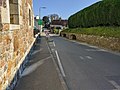 The main road through the village. The village has a large number of calming chicanes.
 -
 A pre-Worboys "SLOW MAJOR ROAD AHEAD" sign at Rozel bay
 -
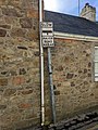
 The road sign design in use in the parish. This is the longest road name in Jersey.
 -
 St Martin's school serves the parish, as well as the north of St Saviour. A new school was constructed in the 2010s.
 -
 Le Saut Geffroy, or Geoffroy's Leap, can be seen here at right, and in the background stretches St. Catherine's breakwater


See also
References
- ^ "Election results 2011". Gov.je. Retrieved 5 October 2012.
- ISBN 978-0-7091-1541-0
- ^ "Size and land cover of Jersey". Government of Jersey. Retrieved 13 December 2020.
- ^ ISBN 978-1860776502.
- ^ "Members". statesassembly.gov.je. Retrieved 13 March 2021.
- ^ "Jersey election 2011: St Martin". Bbc.co.uk. 17 October 2011. Retrieved 5 October 2012.
- ^ "Results 2018". Vote.je - States of Jersey Elections. Retrieved 13 March 2021.
- ^ https://statesassembly.gov.je/assemblypropositions/2020/p.139-2020.pdf [bare URL PDF]
- ^ Heritage, Jersey. "Mont Orgueil Castle". JerseyHeritage.org. Retrieved 24 December 2020.
- ^ "Jersey Eastern Railway - theislandwiki". www.theislandwiki.org. Retrieved 24 February 2018.
- ^ "New cycle path in the east". jerseyeveningpost.com. Retrieved 24 January 2021.
- ^ "Plans unveiled to extend a popular cycle track: Do we need more routes?". jerseyeveningpost.com. Retrieved 24 January 2021.
- ^ "Road Traffic (Speed Limits) (Jersey) Order 2003". www.jerseylaw.je. Retrieved 24 January 2021.
- ^ "All parishes 'need to join the Island's green lane network'". jerseyeveningpost.com. Retrieved 24 January 2021.
- Jersey Folk Lore, John H. L'Amy, Jersey 1927