
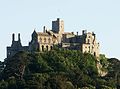
St Michael's Mount
St Michael's Mount
| |
|---|---|
 St Michael's Mount | |
 St Michael's Mount Location within Cornwall | |
| Area | 0.09 sq mi (0.23 km2) |
| OS grid reference | SW514298 |
| • London | 290 miles (467 km) |
| Civil parish |
|
| Unitary authority | |
| Ceremonial county | |
| Region | |
| Country | England |
| Sovereign state | United Kingdom |
| Post town | MARAZION |
| Postcode district | TR17 |
| Dialling code | 01736 |
| Police | Devon and Cornwall |
| Fire | Cornwall |
| Ambulance | South Western |
| UK Parliament | |
| Website | www |
Listed Building – Grade I | |
| Designated | 9 October 1987 |
| Reference no. | 1143795 |
National Register of Historic Parks and Gardens | |
| Designated | 11 June 1987 |
| Reference no. | 1000654 |
St Michael's Mount (
Historically, St Michael's Mount was an English counterpart of Mont-Saint-Michel in Normandy, France, which is also a tidal island, and has a similar conical shape, though Mont-Saint-Michel is much taller.[3]
St Michael's Mount is one of 43 unbridged
Etymology
Its Cornish language name—literally, "the grey rock in a wood"—may represent a folk memory of a time before Mount's Bay was flooded, indicating a description of the mount set in woodland. Remains of trees have been seen at low tides following storms on the beach at Perranuthnoe.[citation needed]
Prehistory
There is evidence of people living in the area during the
None of the flints so far recovered can be positively dated to the
History


St Michael's Mount may have been the site of a monastery from the 8th to the early 11th centuries.
Siege, occupation and ownership
The Mount was sold in 1659 to Colonel John St Aubyn.[13] As of 2021[update] his descendants, the Lords St Levan, remain seated at St Michael's Mount.
18th century
Little is known about the village before the beginning of the 18th century, save that there were a few fishermen's cottages and monastic cottages. After improvements to the harbour in 1727, St Michael's Mount became a flourishing seaport.
In 1755, the Lisbon earthquake caused a tsunami to strike the Cornish coast over 1,000 miles (1,600 km) away. The sea rose six feet (2 m) in 10 minutes at St Michael's Mount, ebbed at the same rate, and continued to rise and fall for five hours. The 19th-century French writer Arnold Boscowitz claimed that "great loss of life and property occurred upon the coasts of Cornwall."[22]
19th century

By 1811, there were 53 houses and four streets. The pier was extended in 1821
During the 18th and 19th centuries, the structure of the castle was romanticised.[14] In the late 19th century, the remains of an anchorite were discovered in a tomb within the domestic chapel.[24]
A short, underground
Some sources, including in the
(750 mm). [29]Second World War
The Mount was fortified in
Sixty-five years after the Second World War, it was suggested based on interviews with contemporaries that the former Nazi Foreign Minister and one-time ambassador to London, Joachim von Ribbentrop, had intended to live at the mount after the planned German conquest. Archived documents revealed that during his time in Britain in the 1930s, when he had proposed an alliance with Nazi Germany, von Ribbentrop frequently visited Cornwall.[31]
National Trust
In 1954, Francis Cecil St Aubyn, 3rd Baron St Levan, gave most of St Michael's Mount to the
Priors and owners of St Michael's Mount
- 1250 Syon Monastery; St Michael's Mount reverted to the Crown
- 1611 Royal grant of St Michael's Mount to Robert, Earl of Salisbury
- 1640 Fee conveyed to William, Earl of Salisbury by Sir Francis Bassett; later sold to the St Aubyn family.[33]
Preservation

The
The harbour, enlarged in 1823 to accommodate vessels of up to 500 tonnes deadweight, has a
Another point of interest on the island is its
The causeway between the mount and Marazion was improved in 1879 by raising it by one foot (30 cm) with sand and stones from the surrounding area.[36] Repairs were completed in March 2016 following damage from the 2014 winter storms.[37] Some studies indicate that any rise in ocean waters as well as existing natural erosion would put some of the Cornwall coast at risk, including St Michael's Mount.[38]
Local government

Until recent times, both the mount and the town of Marazion formed part of the
Geology
The rock exposures around St Michael's Mount provide an opportunity to see many features of the geology of Cornwall in a single locality.[39] The mount is made of the uppermost part of a granite intrusion into metamorphosed Devonian mudstones or pelites. The granite is itself mineralised with a well-developed sheeted greisen vein system. Due to its geology the island's seaward has been designated a Site of Special Scientific Interest since 1995.[40][41]
Granites
There are two types of granite visible on the mount. Most of the intrusion is a tourmaline muscovite granite which is variably porphyritic. This is separated from a biotite muscovite granite by pegmatites.[citation needed]
Devonian pelites
Originally laid down as mudstones these pelites were regionally metamorphosed and deformed (mainly
Mineralisation
The best developed mineralisation is found within the uppermost part of the granite itself in the form of sheeted greisen veins. These steep W-E trending veins are thought to have formed by
Folklore
In prehistoric times, St Michael's Mount may have been a port for the tin trade, and Gavin de Beer made a case for it to be identified with the "tin port" Ictis/Ictin mentioned by Posidonius.[7]
There are popular claims of a tradition that the Archangel Michael appeared before local fishermen on the mount in the 5th century AD.[42] But in fact this is a modern myth. The earliest appearance of it is in a version by John Mirk, copying details of the medieval legend for Mont-Saint-Michel from the Golden Legend.[43] The folk-story was examined and found to be based on a 15th-century misunderstanding by Max Muller.
The chronicler John of Worcester[44] relates under the year 1099 that St Michael's Mount was located five or six miles (10 km) from the sea, enclosed in a thick wood, but that on the third day of November the sea overflowed the land, destroying many towns and drowning many people as well as innumerable oxen and sheep; the Anglo-Saxon Chronicle records under the date 11 November 1099, "The sea-flood sprung up to such a height, and did so much harm, as no man remembered that it ever did before".[45] The Cornish legend of Lyonesse, an ancient kingdom said to have extended from Penwith toward the Isles of Scilly, also talks of land being inundated by the sea.
One of the earliest references to the mount (originally named "Dynsol" or "Dinsul"), was in the mid 11th century when it was "Sanctus Michael beside the sea".[46][47]
In the 1600s, John Milton used the Mount as the setting for the finale of what was once one of the most famous poems in English literature, his "Lycidas", which drew on the traditional sea-lore that had it that the archangel Michael sat in a great stone chair at the top of the Mount, seeing far over the sea and thus protecting England. In the mid-1850s the poem's scenes of the drowning of Lycidas, in the seas below the Mount, were illustrated in engravings and paintings by J. M. W. Turner. The poem drew together various traditions from the Bible, classical mythology and local folklore to offer an elegy for the pagan world that had faded away.[citation needed]
Legend
During the 6th century, before a castle was built, according to legend, the island was once home to an 18-foot giant named Cormoran, who lived in a cave with his ill-gotten treasures obtained by terrorizing local towns and villages. That is, until a young farmer's son named Jack took on this gigantic menace, who had an appetite for cattle and children, and killed him by trapping him in a concealed pit, bringing down his axe upon his head. When he returned home, the elders in the village gave him a hero's welcome, and henceforth, called him "Jack the Giant Killer".[citation needed]
In modern popular culture
The mount has featured in a number of films, including the 1979 film Dracula, where it was prominently featured as the exterior of Castle Dracula.[48]
- It appeared in the 1983 James Bond film Never Say Never Again, as two air-launched cruise missiles armed with nuclear warheads fly over the English countryside and out to sea, passing directly over St Michael's Mount.
- In the 2003 film Pascal Sauvage's French chateau,
- In 2012 it was a Mariah Mundi and the Midas Box
- In 2021 it was used for the Game of Thrones prequel series House of the Dragon.[49]
- "Mt Saint Michel + Saint Michaels Mount" is the title of an experimental electronic track by musician Aphex Twin, who grew up in Cornwall, and in Michael Moorcock's series of Fantasy novels about Prince Corum, a fictionalised version of St Michael's Mount appears as Moidel's Mount.[citation needed]
- It was one of the locations used on BBC One "Balloon" Idents which were used on the channel from 4 October 1997 to 29 March 2002.[citation needed]
- Under its Cornish name of Karrek Loos yn Koos, the island appears prominently in Giles Kristian's 2018 historical fiction novel Lancelot.[citation needed]
- St Michael's Mount is the setting for The Secrets of Winter, a murder mystery written by Nicola Upson featuring the detectives Archie Penrose and Upson's fictionalized version of the author Josephine Tey, published in 2020.[citation needed]
Images
-
 Castle of St Michael
 -
 Causeway at low tide.
 -
 Aerial View
 -
 Local map from 1946
 -
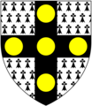 St Aubyn family arms
 -
 Detailed picture of St Michael's Mount castle.
 -
 Burgee of Mount's Bay Sailing Club, Marazion, featuring a silhouette of the island.


_Arms.PNG)


See also
- St Aubyn family
- Mont-Saint-Michel, France
- List of monastic houses in Cornwall
- Cormoran
- Skellig Michael
References
- ^ Place-names in the Standard Written Form (SWF) Main variant Archived 15 May 2013 at the Wayback Machine : List of place-names agreed by the MAGA Signage Panel Archived 15 May 2013 at the Wayback Machine. Cornish Language Partnership.
- ^ O.J.Padel. Cornish Place Names. p. 122.
- ^ Henderson, Charles (1925). Cornish Church Guide. Truro: Oscar Blackford. pp. 160–61.
- ^ "Cornwall tides".
- ^ ISBN 978-1-898166-49-8.
- ISBN 978-0-7524-1442-3.
- ^ JSTOR 1793956.
- ^ ICTIS INSVLA at roman-britain.co.uk, accessed 7 February 2012
- ^ ISBN 9780140710014.
- ^ a b Henderson, Charles (1925). Cornish Church Guide. Truro: Oscar Blackford. pp. 160–61.
- ^ Fletcher, J. R. (Canon), Short History of Saint Michael's Mount, Published at St Michael's Mount 1951.
- ISBN 978-0907018582.
- ^ a b c d e One or more of the preceding sentences incorporates text from a publication now in the public domain: Chisholm, Hugh, ed. (1911). "St Michael's Mount". Encyclopædia Britannica (11th ed.). Cambridge University Press.
- ^ a b "St Michael's Mount". CastlesFortsBattles.co.uk. Retrieved 23 July 2019.
- ^ Richard Carew (1811). Carew's Survey of Cornwall. T. Bensley. p. 379.
- ^ John Harvey (1948). The Plantagenets. B.T.Batsford Ltd.
- ^ Historic England. "THE CHURCH OF SAINT MICHAEL, St. Michael's Mount (1310728)". National Heritage List for England. Retrieved 6 August 2019.
- ^ Musson, RMW (2008). "The seismicity of the British Isles to 1600" (PDF). British Geological Survey (Earth Hazards and Systems): 37. Retrieved 6 August 2019.
- ^ Harry, Carlene. "Morvah - which St Bridget?". Penwith Local History Group. Retrieved 17 May 2018.
- ^ a b "St Buryan deanery and the Priory of St Michael's Mount", King’s College Estates Records, vol. KCAR/6/2/138, 13 May 2014
- ^ J P C Roach (ed.). "The colleges and halls: King's'". A History of the County of Cambridge and the Isle of Ely: Volume 3, the City and University of Cambridge.
- ^ "Sources of Cornish History – The Lisbon Earthquake". Cornwall Council. 12 September 2011. Retrieved 16 September 2012.
- ^ "St Michael's Mount". New Monthly Magazine. May 1821. p. 259. Retrieved 27 December 2012.
- ^ "Things to know before Applying for Payday Advance Online – Cornwall OPC". Retrieved 13 June 2020.
- ^ Sunders, Charlie (September 2018). Bennett, Paul (ed.). "Drecky Express (Visit report)". Narrow Gauge News (348). Narrow Gauge Railway Society.
- ^ "St Michaels Mount, Cornish Cliff Railway". Hows Website. Archived from the original on 5 November 2016. Retrieved 28 September 2016.
- ^ "St Michael's Mount Cliff Railway". South Western Historical Society. Retrieved 28 September 2016.
- ISBN 978-1-904474-56-2.
- ISSN 0033-8923.
- ISBN 978-1-902771-53-3.
- ^ Vanessa Thorpe (3 October 2010). "Nazi foreign minister planned to own Cornwall as his retirement home". The Observer. Retrieved 16 September 2012.
- ^ Plea Rolls of the Court of Common Pleas; National Archives; CP 40/541; Year 1396; Richard II; www.uh.edu: Plaintiff
- ^ A short history of St Michael's Mount;Appendix B ; by the Rev. W. S. Lach-Szrma; 1878; https://archive.org/stream/ashorthistorype00lachgoog/ashorthistorype00lachgoog_djvu.txt
- ^ "Events".
- ^ "Parish population 2011". GENUKI. Archived from the original on 7 July 2001. Retrieved 14 February 2015.
- ^ "Marazion". The Cornishman. No. 61. 11 September 1879. p. 4.
- ^ "Causeway at St Michael's Mount restored". BBC News. 22 March 2016. Retrieved 26 March 2016.
- ^ Steven Morris (13 October 2008). "South-west England's treasures in danger". The Guardian. Retrieved 16 September 2012.
- ^ "Marazion to Porthleven (virtual geological field excursion)" (PDF). University of Exeter. Retrieved 16 September 2012.
- ^ "St Michael's Mount" (PDF). Natural England. 31 March 1995. Archived from the original (PDF) on 4 October 2013. Retrieved 30 October 2014.
- ISBN 978-1848767-010.
- ^ "Timeline of The Mount". St. Michael's Mount. Archived from the original on 20 January 2011. Retrieved 16 September 2012.
- ISBN 978-1-84383-128-0.
- ^ Noted by de Beer 1960:162f as "Florence of Worcester" in Thomas Forester's edition, London, 1854:206.
- ^ Ingram, James (trans.) (1823), The Anglo-Saxon Chronicle, vol. 180
- ^ Padel, O J. "The Cornish background of the Tristan Stories". Cambridge Medieval Studies. 1: 53–81.
- ^ Padel, O J (1985). Cornish Place-name Elements. English Place-names Society Volumes 56/57.
- ISBN 9780786451937.
- ^ Selcke, Dan (23 April 2021). "House of the Dragon films at Driftmark, seat of House Velaryon". Fansided. Retrieved 15 May 2021.
Further reading
- John Taylor, Albion: the earliest history (Dublin, 2016)
External links
St Michael's Mount.
- Official website
- St Michael's Mount information at the National Trust
- Pliny: Naturalis Historia (IV:XVI.102-4)
- Cornwall Record Office Online Catalogue for St Michael's Mount Archived 4 March 2016 at the Wayback Machine
- Historic England. "Details from listed building database (1143795)". National Heritage List for England.
- St Michaels Mount (photo by Chris Hasenbichler)
- The Medieval Legend of the Appearance of St Michael at St Michael's Mount in Cornwall: a Modern Myth - Discussion of all the sources.
- Crossing times to St Michael's Mount
| Unitary authorities | |
|---|---|
| Major settlements (cities in italics) |
|
| Rivers | |
| Topics | |
| International | |
|---|---|
| Other | |