
Sudova Vyshnia
This article needs additional citations for verification. (March 2012) |
Sudova Vyshnia
Судова Вишня | |
|---|---|
 Town hall | |
|
UTC+3 (EEST) | |
| Postal code | 81340 |
| Area code | +380 |
Sudova Vyshnia (Ukrainian: Судова Вишня) is a small city in the Yavoriv Raion of the Lviv Oblast (region) of Ukraine. It hosts the administration of Sudova Vyshnia urban hromada, one of the hromadas of Ukraine.[1] Its population is 6,470 (2022 estimate).[2]
The town has a number of Catholic cathedrals and a secondary school, and is a market centre for the surrounding agricultural area. In the past the town contained a horse farm, providing a horse stud service for the area, some of the horse studs being very expensive. On the outskirts there is a hippodrome.[3]
Geography
Sudova Vyshnia is located about 50 km (31 mi) west of Lviv, on the highway ![]() M 11 (Shehyni – Lviv) and railroad to Przemyśl in Poland. The city is also the terminus of route P40, that stretches all the way to Rava-Ruska.
M 11 (Shehyni – Lviv) and railroad to Przemyśl in Poland. The city is also the terminus of route P40, that stretches all the way to Rava-Ruska.
The Vishnya river flows through the town in a westerly direction, eventually joining the San in Poland. The railway line (twin track) leads to Kraków and Silesia in Poland, a main route for carrying coal to the former USSR.
History
Sudova Vyshnia was first mentioned in the
Sudova Vyshnia received its
In 1772, the town was annexed by the Habsburg Empire, as part of Habsburg Austrian Galicia, where it remained until late 1918. In the Second Polish Republic, Sądowa Wisznia belonged to Mościska County, Lwów Voivodeship. During the September 1939 Invasion of Poland, the Battle of Jaworów took place in the area of the town.
When
When under the administration of
After World War II, the Soviet regime used a Catholic church (Church of St Mary) that existed since the 14th century as a warehouse until 1989.
Today, Sudova Vyshnia is one of the centers of the Poles in Ukraine, with a local office of the Association of Polish Culture of the Lviv Land.
Until 18 July 2020, Sudova Vyshnia belonged to Mostyska Raion. The raion was abolished in July 2020 as part of the administrative reform of Ukraine, which reduced the number of raions of Lviv Oblast to seven. The area of Mostyska Raion was merged into Yavoriv Raion.[4][5]
Notable people
Born
- Ivan Vyshenskyi (1550–1620), an Eastern Orthodox monk
- Stefan Czmil (1914–1978), an Eastern Catholic bishop
- Bohdan Shust (born 1986), a professional football player
Resided
- Jan Mars (1853–1924), an owner of Sudova Vyshnia
- Unitarianism
Gallery
-
 Sudova Vyshnia school
 -
 City's oldest church, Transfiguration Church
 -
 Transfiguration Church Bell Tower
 -
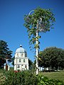
 Holy Trinity Church
 -
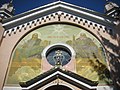 Holy Trinity Church, entrance fresco
 -
 a street view
 -
 Church of St Mary, a Helper of Christians


References
- ^ "Судововишнянская громада" (in Russian). Портал об'єднаних громад України.
- ^ Чисельність наявного населення України на 1 січня 2022 [Number of Present Population of Ukraine, as of January 1, 2022] (PDF) (in Ukrainian and English). Kyiv: State Statistics Service of Ukraine. Archived (PDF) from the original on 4 July 2022.
- ^ "Cудова Вишня". castles.com.ua. Retrieved 2023-12-29.
- ^ "Про утворення та ліквідацію районів. Постанова Верховної Ради України № 807-ІХ". Голос України (in Ukrainian). 2020-07-18. Retrieved 2020-10-03.
- ^ "Нові райони: карти + склад" (in Ukrainian). Міністерство розвитку громад та територій України.
External links
- Brief info[permanent dead link] at the Verkhovna Rada website
- Sudova Vyshnia at the Castles and temples of Ukraine
| International | |
|---|---|
| National | |