
Sugarloaf Mountain
You can help expand this article with text translated from the corresponding article in Portuguese. (July 2011) Click [show] for important translation instructions.
|
| Sugarloaf Mountain | |
|---|---|
 | |
| Highest point | |
| Elevation | 396 m (1,299 ft) |
| Coordinates | 22°56′55″S 43°09′26″W / 22.94861°S 43.15722°W |
| Geography | |
 Sugarloaf Mountain Location in Rio de Janeiro | |
| Location | Rio de Janeiro |

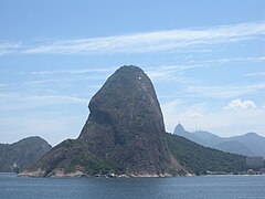
Sugarloaf Mountain (Portuguese: Pão de Açúcar, pronounced [ˈpɐ̃w dʒ(i) ɐˈsukaʁ]) is a peak situated in Rio de Janeiro, Brazil, at the mouth of Guanabara Bay on a peninsula that juts out into the Atlantic Ocean. Rising 396 m (1,299 ft) above the harbor, the peak is named for its resemblance to the traditional shape of concentrated refined loaf sugar. It is known worldwide for its cableway and panoramic views of the city and beyond.
The mountain is one of several monolithic granite and quartz mountains that rise straight from the water's edge around Rio de Janeiro. Geologically, it is considered part of a family of steep-sided rock outcroppings known as non-inselberg bornhardts.
The mountain is protected by the Sugarloaf Mountain and Urca Hill Natural Monument, created in 2006. This became part of a World Heritage Site declared by UNESCO in 2012.[1]
Origins of the name
The name Sugarloaf was coined in the 16th century by the Portuguese during the heyday of sugarcane trade in Brazil due to sugar imports from the Portuguese conquest of Goa, according to historian Vieira Fazenda. Blocks of sugar were placed in conical molds made of clay to be transported on ships. The form of the peak reminded them of the well-known resulting "sugarloaf" shape, and the nickname has since been extended to be a general descriptor for formations of this kind.[2]
Cable car
A glass-walled cable car (bondinho or, more formally, teleférico), capable of holding 65 people, runs along a 1,400 m (4,600 ft) route between the peaks of Sugarloaf and Morro da Urca every 20 minutes. The original cable car line was built in 1912 and rebuilt around 1972–73 and in 2008. The cable car goes from a ground station, at the base of Morro da Babilônia, to Morro da Urca and thence to Sugarloaf's summit.
Reaching the summit
To reach the summit, passengers take two cable cars. The first ascends to the shorter Morro da Urca, 220 m (722 ft) high. The second car ascends to Pão de Açúcar.[3] The Swiss-made bubble-shaped cars offer passengers 360° views of the surrounding city.[4] The ascent takes three minutes.[citation needed]
Timeline
- 1907 – Brazilian engineer Augusto Ferreira Ramos had the idea of linking the hills through a path in the air.
- 1910 – The same engineer founded the Society of Sugar Loaf and the same year the works were started. The project was commissioned in Germany and built by Brazilian workers. All parts were taken by climbing mountains or lifted by steel cables.
- 1912 – Opening of the cableway, the first in Brazil and the third of this kind worldwide;[5] the first cable cars were made of coated wood and were used for 61 years.
- 1973 – The current models of cars were put into operation. This increased the carrying capacity by almost ten times.
- 2009 – Inauguration of the next generation of cable cars that had already been purchased and are on display at the base of Red Beach
- 2020 – Closed in March[6] and reopened in August[7][8]

Rock climbing
There are rock climbing routes on Sugarloaf that are mostly multipitch and are a mixture of sport and trad.[9] There are also two other mountains in the area with technical rock climbing, Morro da Babilônia[10] and Morro da Urca.[11] Together, they form one of the largest urban climbing areas in the world, with more than 270 routes, between 1 and 10 pitches long.
Appearances in media
- In 1933's Flying Down to Rio (with Fred Astaire and Ginger Rogers, among others), the beachside Hotel Atlântico has views across the bay looking toward Sugarloaf Mountain.
- In the 1979 James Bond film Moonraker, the villainous henchman Jaws (played by Richard Kiel) attempts to kill 007 (Roger Moore) and the agent's ally, Dr. Holly Goodhead (Lois Chiles), on a cable car. However, Bond and Goodhead escape and Jaws collides with the building at the bottom of the cable car route, demolishing the building, but escaping unscathed.
- Herb Alpert recorded a song titled "Sugarloaf" for his 1982 album Fandango.
- The mountain and cable car are featured in The Simpsons episode "Blame It on Lisa", aired in 2002.
- Mechanic: Resurrection (2016), starring Jason Statham. At the beginning of the film Arthur Bishop (Statham) is attacked at a restaurant on Morro da Urca and escapes on the roof of a cable car.
- The 2023 reality competition show 007: Road to a Million, a spin-off of the Bond franchise, featured Sugarloaf Mountain in two episodes.[12] Two of the show's participants scaled the mountain before climbing outside of a cable car, as an homage to Moonraker.[13]
Gallery
Sugarloaf in art, 16th to 19th century
-
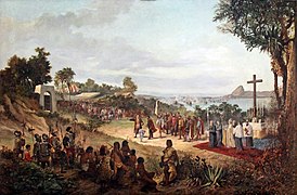 Founding of Rio de Janeiro in 1565. Sugarloaf is seen in the background.
 -
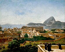 View of Sugarloaf from the terrace of the Convento de Santo Antônio (Convent of St. Anthony), c. 1816. Painting by Nicolas-Antoine Taunay.
 -
 View of Sugarloaf from the Silvestre road, c. 1823. Painting by Charles Landseer.
 -
 Emperor Pedro I of Brazil (also King of Portugal as Pedro IV) with his crown and the Sugarloaf in the background, c. 1825
 -
 Sugarloaf and the Nossa Senhora da Glória do Outeiro (Our Lady of the Glory of the Hill) church as seen from the neighborhood of Glória, c. 1846. Painting by Eduard Hildebrandt.


20th and 21st centuries
-
 Sugarloaf in 1914
 -
 Military barracks near the Sugarloaf on fire after the communist uprising of 1935
 -
 The Sugarloaf wooden cable car in the 1940s
 -
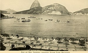
 Higher aerial view, 1967
 -
 View of Sugarloaf from Christ the Redeemer on Corcovado
 -
 Cable cars from Sugarloaf Mountain
 -
 View of Sugarloaf Mountain from seaward side; Corcovado and Christ the Redeemer are seen in the background.
 -
 View of Rio de Janeiro from the Sugarloaf
 -
 Sugarloaf as seen from Praia Vermelha (Red Beach)
 -
 Botafogo Bayand Sugarloaf
 -
 Botafogo Bay and beach with Sugarloaf in the background
 -
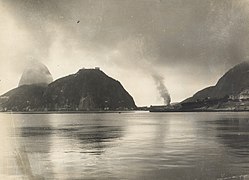
 Aerial view
 -
 Sugarloaf withDowntown Rioin the foreground
 -
 View from the city of Niterói
_(14775856642).jpg)


.jpg)

.jpg)

References
- ^ Monumento Natural dos Morros do Pão de Açúcar e da Urca (in Portuguese), SMAC: Secretaria Municipal de Meio Ambiente, retrieved 2017-01-15
- ISBN 978-0-19-956766-9.
- ISBN 1-74059-910-1
- ^ "Highlights of Rio de Janeiro". Insight Guides. The mighty Sugar Loaf Mountain (Pão de Açúcar). Retrieved 1 April 2024.
- ^ "Sugarloaf Mountain". The Armchair Mountaineer. Retrieved 2021-02-13.
- ^ "Rio's Christ statue closes and state of emergency decreed". ABC News (American). Retrieved 16 August 2020.
- ^ "Brazil's Christ the Redeemer statue and Sugarloaf Mountain reopen Saturday". CNN. Retrieved 16 August 2020.
- ^ "Brazil's Christ the Redeemer Statue Reopened After Being Closed for Nearly 5 Months". Travel + Leisure. Retrieved 2024-04-02.
- ^ "Rock Climbing in Pao de Acucar (Sugarloaf), Rio de Janeiro".
- ^ "Rock Climbing in Morro da Babilonia, Rio de Janeiro".
- ^ "Rock Climbing in Morro da Urca, Rio de Janeiro".
- ^ Haysom, Sam (2023-11-10). "'007: Road to a Million' review: A tense Bond-themed game show that slowly builds". Mashable. Retrieved 2024-04-02.
- ^ "007: Road to a Million cast faced their 'biggest fears' for James Bond reality show: 'I was terrified!'". Yahoo News. 2023-11-09. Retrieved 2024-04-02.
External links
 Media related to Sugarloaf Mountain at Wikimedia Commons
- Official website
 — (in Portuguese, English, and Spanish)
| International | |
|---|---|
| Geographic | |