
Suisun City, California
City of Suisun City | ||
|---|---|---|
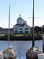
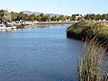
 Suisun City Marina with City Hall in the background | ||
|
FIPS code 06-75630 | | |
| GNIS feature IDs | 1656340, 2411995 | |
| Website | www | |
Suisun City (
Etymology
The city takes its name from the adjacent Suisun Bay, which in turn is named for the Suisun people, an Indian tribe of the area.[10]
Geography
Suisun City is located at 38°14′42″N 122°1′1″W / 38.24500°N 122.01694°W (38.244863, -122.017048).[11]
According to the United States Census Bureau, the city has a total area of 4.2 square miles (11 km2), of which 4.1 square miles (11 km2) is land and 0.06 square miles (0.16 km2) (1.39%) is water.
The city is adjacent to Suisun Marsh, at 84,000 acres (34,000 ha) the largest contiguous estuarine marsh remaining on the west coast of North America.
Climate
According to the
Demographics
| Census | Pop. | Note | %± |
|---|---|---|---|
| 1870 | 462 | — | |
| 1880 | 554 | 19.9% | |
| 1890 | 499 | −9.9% | |
| 1900 | 625 | 25.3% | |
| 1910 | 641 | 2.6% | |
| 1920 | 769 | 20.0% | |
| 1930 | 905 | 17.7% | |
| 1940 | 706 | −22.0% | |
| 1950 | 946 | 34.0% | |
| 1960 | 2,470 | 161.1% | |
| 1970 | 2,917 | 18.1% | |
| 1980 | 11,087 | 280.1% | |
| 1990 | 22,686 | 104.6% | |
| 2000 | 26,118 | 15.1% | |
| 2010 | 28,111 | 7.6% | |
| 2020 | 29,518 | 5.0% | |
| U.S. Decennial Census[13] | |||
2010
The
The Census reported that 28,067 people (99.8% of the population) lived in households, 27 (0.1%) lived in non-institutionalized group quarters, and 17 (0.1%) were institutionalized.
There were 8,918 households, of which 4,013 (45.0%) had children under the age of 18 living in them, 4,856 (54.5%) were
7,737 people (27.5%) were under the age of 18, 2,950 people (10.5%) aged 18 to 24, 7,850 people (27.9%) aged 25 to 44, 7,418 people (26.4%) aged 45 to 64, and 2,156 people (7.7%) who were 65 years of age or older. The median age was 33.0 years. For every 100 females, there were 96.9 males. For every 100 females age 18 and over, there were 92.9 males.
There were 9,454 housing units at an average density of 2,270.9 per square mile (876.8/km2), of which 6,184 (69.3%) were owner-occupied, and 2,734 (30.7%) were occupied by renters. The homeowner vacancy rate was 3.0%; the rental vacancy rate was 5.9%. 19,372 people (68.9% of the population) lived in owner-occupied housing units and 8,695 people (30.9%) lived in rental housing units.
2000
At the 2000
There were 7,987 households, of which 47.8% had children under the age of 18, 62.4% were married couples living together, 13.1% had a female householder with no husband present, and 19.3% were non-families. 14.3% of all households were made up of individuals, and 3.0% had someone living alone who was 65 years of age or older. The average household size was 3.26 and the average family size was 3.59.
32.5% of the population were under the age of 18, 8.9% from 18 to 24, 32.5% from 25 to 44, 20.3% from 45 to 64, and 5.7% who were 65 years of age or older. The median age was 32 years. For every 100 females, there were 98.1 males. For every 100 females age 18 and over, there were 95.1 males.
The
Education
Schools in Fairfield and Suisun are operated by the Fairfield-Suisun Unified School District.

Schools
- Suisun Elementary School
- Crescent Elementary School
- Crystal Middle School
- Dan O Root II Elementary School
High schools
- Armijo High School
- Fairfield High School
- Rodriguez High School
History

Suisun City was established in the 1850s. Its location made it ideal for commerce and transportation during the
In 1868—1869, it was connected to the First transcontinental railroad at Sacramento via the California Pacific Railroad (Cal-P) main line, expanding the region's reach across the United States. By 1879 Central Pacific Railroad owned the Cal-P mainline and rerouted the transcontinental overland route through the new branch from Port Costa, via the railroad ferry Solano to Benicia, across the Suisun Marsh to Suisun City, putting the region directly on the overland route from San Francisco to Ogden and beyond.[16]
In 1888, a fire destroyed much of downtown Suisun, including many city landmarks, such as the Robert Hotel, Crowley’s saloon, the Union Hotel, and the Orkel grain warehouses. Citizens considered abandoning the city after the devastation, but instead decided to rebuild and raise money to construct a waterworks system that would allow them to fight future fires more effectively.[17]
In the 1960s and 1970s, Suisun City experienced rapid growth as the San Francisco Bay Area's suburban ring expanded to the formerly rural Solano County. Also in the 1960s, Interstate 80 was constructed two miles (3 km) outside the city, effectively moving commercial traffic away from railways and water conveyance.
Transportation

- Fairfield and Suisun Transit
- Suisun/Fairfield Amtrak station
Gallery
-
 Suisun City Hall
 -
 Solano Yacht Club in Suisun City
 -
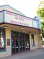 Suisun Harbor Theatre
 -
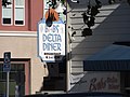 Bab's Delta Diner in Suisun City
 -
 Suisun City Hall as seen across Suisun Slough between two boats in the harbor
 -
 Harbor Plaza in Suisun City
 -
 Veterans Hall and Solano Transportation Authority in Suisun City
 -
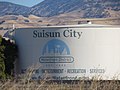 Suisun City water tower
 -
 Harbor Lighthouse in Suisun City from across Suisun Slough
 -
 Suisun Slough as seen from Solano Yacht Club


Sister cities
References
- ^ "California Cities by Incorporation Date". California Association of Local Agency Formation Commissions. Archived from the original (Word) on October 17, 2013. Retrieved August 25, 2014.
- ^ a b "Statewide Database". UC Regents. Archived from the original on February 1, 2015. Retrieved January 27, 2015.
- ^ "California's 3rd Congressional District - Representatives & District Map". Civic Impulse, LLC. Retrieved March 9, 2013.
- ^ "Suisun City Council". City of Suisun City. Retrieved March 5, 2023.
- ^ "2019 U.S. Gazetteer Files". United States Census Bureau. Retrieved July 1, 2020.
- ^ "Suisun". Geographic Names Information System. United States Geological Survey, United States Department of the Interior. Retrieved January 27, 2015.
- ^ "Suisun City (city) QuickFacts". United States Census Bureau. Archived from the original on September 1, 2012. Retrieved March 18, 2015.
- ^ "Population and Housing Unit Estimates". United States Census Bureau. May 24, 2020. Retrieved May 27, 2020.
- ^ "Suisun City". US Census Bureau. Retrieved August 24, 2022.
- ISBN 9780403093182.
- ^ "US Gazetteer files: 2010, 2000, and 1990". United States Census Bureau. February 12, 2011. Retrieved April 23, 2011.
- ^ Climate Summary for Suisun City, California
- ^ "Census of Population and Housing". Census.gov. Retrieved June 4, 2015.
- ^ "2010 Census Interactive Population Search: CA - Suisun City city". U.S. Census Bureau. Archived from the original on July 15, 2014. Retrieved July 12, 2014.
- ^ "U.S. Census website". United States Census Bureau. Retrieved January 31, 2008.
- ^ "THE "SOLANO." The New Route Between Benicia and Martinez in Operation". cdnc.ucr.edu. Daily Alta California, Volume 31, Number 10851. December 30, 1879. Retrieved June 21, 2021.
Sunday [28 Dec 1879], the first passenger train passed over the new route of the Central Pacific Railroad, crossing the strait at Benicia on the new ferry-boat Solano.
- ^ Eberling, Barry. "Suisun City's worst fiery nightmare hit 125 years ago". Daily Republic.
- ^ "Memorandum of Agreement Establishing the Sister City Relationship Between The Municipality of Naguilian, La Union, Philippines and The City of Suisun City, California, United States of America" (PDF). Sistercities.org. May 16, 2006. Retrieved September 15, 2018.
External links
Municipalities and communities of Solano County, California, United States | ||
|---|---|---|
| Cities |  | |
| CDPs | ||
| Unincorporated communities |
| |
| Ghost town | ||
| ||
| Bodies of water |
|  | |||||||||||
|---|---|---|---|---|---|---|---|---|---|---|---|---|---|
| Counties | |||||||||||||
| Cities and towns |
| ||||||||||||
| CDPs over 10k | |||||||||||||
| Sub-regions | |||||||||||||
| Other | |||||||||||||
Places adjacent to Suisun City, California | |
|---|---|
| International | |
|---|---|
| National | |
| Geographic | |