
Sulawesi
 Topographic map of Sulawesi | |
 Provincial division of Sulawesi | |
| Other names | Celebes |
|---|---|
| Geography | |
| Location | Indonesia |
| Coordinates | 02°S 121°E / 2°S 121°E |
| Archipelago | Greater Sunda Islands |
| Area | 186,216.16 km2 (71,898.46 sq mi) |
| Area rank | 11th |
| Highest elevation | 3,478 m (11411 ft) |
| Highest point | Latimojong |
| Administration | |
Indonesia | |
| Provinces (capital) |
|
| Largest settlement | Bajau, Mongondow |
Sulawesi (/ˌsuːləˈweɪsi/ SOO-lə-WAY-see),[1] also known as Celebes (/ˈsɛlɪbiːz, səˈliːbiːz/ SEL-ib-eez, sə-LEE-beez),[2] is an island in Indonesia. One of the four Greater Sunda Islands, and the world's 11th-largest island, it is situated east of Borneo, west of the Maluku Islands, and south of Mindanao and the Sulu Archipelago. Within Indonesia, only Sumatra, Borneo, and Papua are larger in territory, and only Java and Sumatra are more populous.
The landmass of Sulawesi includes four peninsulas: the northern
Etymology
The name Sulawesi possibly comes from the words sula ("island") and besi ("iron") and may refer to the historical export of
The name Celebes was originally given to the island by
Geography
Sulawesi is the
The
Minor islands
The
Geology
The island slopes up from the shores of the deep seas surrounding the island to a high, mostly non-volcanic, mountainous interior. Active volcanoes are found in the northern Minahasa Peninsula, stretching north to the Sangihe Islands. The northern peninsula contains several active volcanoes such as Mount Lokon, Mount Awu, Soputan and Karangetang.
According to
Off the eastern coast of Sulawesi, the North Banda Sea was created through subduction rollback during the early Miocene. Evidence for this tectonic event lies with the extensive interconnected fault network found in the area, a volcanic seamount with its surrounding ridges, and an accretionary wedge. Off the coast of east Selawesti and Banggai is an accumulation of carbonate rocks from the late Miocene. These carbonates are likely pinnacle reefs and the carbonate platform has a total thickness of around 180–770 meters.[13]
Sulawesi, in contrast to most of the other islands in the
Bone Basin
The Bone Basin lies between the eastern and western arms of Sulawesi. According to recent studies, the basin has been opened up due to extensional forces.[15] The basin is bounded by normal faults on each side of the basin. Each side of the basin is surrounded by uplifted basement rock with young sediments found in the middle. The past geological history has allowed for a large accumulation of carbonates which could lead to a higher potential of oil and gas occurrences. However, the faults present in the basin makes it a very complicated system.
Prehistory
The oldest evidence for humans on Sulawesi are stone tools produced by archaic humans, dating from over 200,000 to 100,000 years ago, that were found at the Talepu site in southwestern Sulawesi.[16]
Before October 2014, the settlement of South Sulawesi by modern humans had been dated to c. 30,000 BC on the basis of radiocarbon dates obtained from rock shelters in Maros.[17] No earlier evidence of human occupation had at that point been found, but the island almost certainly formed part of the land bridge used for the settlement of Australia and New Guinea by at least 40,000 BC.[18] There is no evidence of Homo erectus having reached Sulawesi; crude stone tools first discovered in 1947 on the right bank of the Walanae River at Barru (now part of Bone Regency), which were thought to date to the Pleistocene on the basis of their association with vertebrate fossils,[19] are now thought to date to perhaps 50,000 BC.[20]

Following Peter Bellwood's model of a southward migration of Austronesian-speaking farmers (AN),[21] radiocarbon dates from caves in Maros suggest a date in the mid-second millennium BC for the arrival of a group from east Borneo speaking a Proto-South Sulawesi language (PSS). Initial settlement was probably around the mouth of the Sa'dan river, on the northwest coast of the peninsula, although the south coast has also been suggested.[22]
Subsequent migrations across the mountainous landscape resulted in the geographical isolation of PSS speakers and the evolution of their languages into the eight families of the South Sulawesi language group.

Pre-1200 Bugis society was most likely organized into
In Central Sulawesi, there are more than 400 granite megaliths, which various archaeological studies have dated to be from 3000 BC to AD 1300. They vary in size from a few centimeters to approximately 4.5 meters (15 ft). The original purpose of the megaliths is unknown. Approximately 30 of the megaliths represent human forms. Other megaliths are in form of large pots (Kalamba) and stone plates (Tutu'na).[24][25]
A burial of a woman associated with the hunter-gatherer Toalean culture dating to 7,000 years ago has yielded DNA that has provided rare insight into early migrations in and through the region.[26][27]
Oldest known cave art
In October 2014, it was announced that
Dr. Maxime Aubert, of Griffith University in Queensland, Australia, said that was the minimum age for the outline in Pettakere Cave in Maros, and added: "Next to it is a pig that has a minimum age of 35,400 years old, and this is one of the oldest figurative depictions in the world, if not the oldest one."[28]
On 11 December 2019, a team of researchers led by Dr. Maxime Aubert announced the discovery of the oldest hunting scenes in prehistoric art in the world that is more than 44,000 years old from the limestone cave of Leang Bulu' Sipong 4. Archaeologists determined the age of the depiction of hunting a pig and buffalo thanks to the calcite 'popcorn', different isotope levels of radioactive uranium and thorium.[29][30][31]
In March 2020, two small stone 'plaquettes' were found by Griffith University archaeologists in the Leang Bulu Bettue cave, dated to a time between 26,000 and 14,000 years ago.[32] While one of the stones contained an anoa (water buffalo) and what may be a flower, star, or eye, another depicted astronomic rays of light.[33][34][35]
In January 2021, archaeologists announced the discovery of cave art that is at least 45,500 years old in a Leang Tedongnge cave. According to the journal Science Advances, the cave painting of a warty pig is the earliest evidence of human settlement of the region. An adult male pig, measuring 136 cm x 54 cm and what is likely a Sulawesi or Celebes warty pig (Sus celebensis), was depicted with horn-like facial warts and two hand prints above its hindquarters.[36] According to co-author Adam Brumm, there are two other pigs that are partly preserved and it appears the warty pig was observing a fight between the two other pigs.[37][38][39][40]
History

A bronze Amaravathi statue was discovered at Sikendeng, South Sulawesi near Karama river in 1921 which was dated to 2nd–7th century AD by Bosch (1933).[41] In 1975, small locally made Buddhist statues from 10th-11th century were also discovered in Bontoharu, on the island of Selayar, South Sulawesi.[42]
Starting in the 13th century, access to prestige trade goods and to sources of iron started to alter long-standing cultural patterns and to permit ambitious individuals to build larger political units. It is not known why these two ingredients appeared together; one was perhaps the product of the other.
In 1367, several identified polities located on the island were mentioned in the Javanese manuscript
The first Europeans to visit the island (which they believed to be an archipelago due to its contorted shape) were the
In 1905, the entire island became part of the Dutch state colony of the
Picture gallery
-
 Tandako dancers and a musician in Pasere Maloku, Sulawesi.
 -
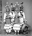
 Tandako pajogé dancers from Pasere Maloku, Celebes (now Sulawesi)
 -
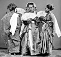 Padjogé dancers in Maros, Sulawesi, in the 1870s.
 -
 Tandako pajogé dancers and musicians in Gorontalo, North Celebes, circa 1870s.


Central Sulawesi
The Portuguese were rumoured to have a fort in Parigi in 1555.[49] The Kaili were an important group based in the Palu valley and related to the Toraja. Scholars relate[citation needed] that their control swayed under Ternate and Makassar, but this might have been a decision by the Dutch to give their vassals a chance to govern a difficult group. Padbruge commented that in the 1700s the Kaili population was significantly high and were a highly militant society. In the 1850s, a civil war erupted between the Kaili groups, including the Banawa, in which the Dutch colonial government decided to intervene.[50]
In the late 19th century, the Sarasins journeyed through the Palu valley as part of a major initiative to bring the Kaili under Dutch rule. Some very surprising and interesting photographs were taken of shamans called Tadulako. Further Christian religious missions entered the area to make one of the most detailed ethnographic studies in the early 20th century.[51] A Swede by the name of Walter Kaudern later studied much of the literature and produced a synthesis. Erskine Downs in the 1950s produced a summary of Kruyts and Andrianis work: "The religion of the Bare'e-Speaking Toradja of Central Celebes," which is invaluable for English-speaking researchers. One of the most recent publications is "When the bones are left," a study of the material culture of central Sulawesi,[52] offering extensive analysis. Also worthy of study are the brilliant works of Monnig Atkinson on the Wana shamans who live in the Mori area.
Population
Population of Sulawesi by province (2020 Census)[53]
The 2000 census population of the provinces of Sulawesi was 14,946,488, about 7.25% of Indonesia's total population.[54] By the 2010 Census the total had reached 17,371,782, and the 2020 Census produced a total of 19,896,951.[55] The official estimate for mid 2022 was 20,304,437.[56] The largest city on Sulawesi is Makassar.
Religion
Religion in Sulawesi (2022)[57]
Though most people identify themselves as Muslims or Christians, they often subscribe to local beliefs and deities as well.
Smaller communities of
Languages
Economy
The economy of Sulawesi is heavily centered around agriculture, fishing, mining, and forestry.[59]
Administration
The island was administered as one province between 1945 and 1960. In 1960 it was divided into two provinces – North and Central Sulawesi, and South and Southeast Sulawesi. In 1964 both of these were again divided, the former into North Sulawesi and Central Sulawesi, and the latter into South Sulawesi and Southeast Sulawesi. Today, it is subdivided into six
. Among these, the newest provinces are Gorontalo, established in 2000 from part of North Sulawesi, and West Sulawesi, established in 2004 from part of South Sulawesi.The largest cities on the island are the provincial capitals of Makassar, Manado, Palu, Kendari, and Gorontalo (the provincial capital of West Sulawesi – the town of Mamuju – is not a city); there are six other cities – Bitung, Palopo, Bau-Bau, Parepare, Kotamobagu and Tomohun.
|
|
Flora and fauna

Sulawesi is part of Wallacea, meaning that it has a mix of both Indomalayan and Australasian species that reached the island by crossing deep-water oceanic barriers.[60][61] The flora includes one native eucalypt, E. deglupta. There are 8 national parks on the island, of which 4 are mostly marine. The parks with the largest terrestrial area are Bogani Nani Wartabone with 2,871 km2 and Lore Lindu National Park with 2,290 km2. Bunaken National Park, which protects a rich coral ecosystem, has been proposed as a UNESCO World Heritage Site. The coast of northern tip of Sulawesi is identified as a site of highest marine biodiversity importance in the Coral Triangle.[62]
Mammals
Early in the Pleistocene, Sulawesi had a dwarf elephant and a dwarf form of Stegodon, (an elephant relative, S. sompoensis);[63] later both were replaced by larger forms.[64][65] A giant suid, Celebochoerus, was also formerly present.[66] It is thought that many of the migrants to Sulawesi arrived via the Philippines, while Sulawesi in turn served as a way station for migrants to Flores.[67] A Pleistocene faunal turnover is recognized, with the competitive displacement of several indigenous tarsiers by more recently arriving ones and of Celebochoerus by other medium-sized herbivores like the babirusa, anoa and Celebes warty pig.[68]

There are 127 known extant native mammalian species in Sulawesi. A large percentage, 62% (79 species) are
Sulawesi is home to a large number of endemic
While over 20 bat species are present on Sulawesi, only a portion of these are endemic:
Several endemic shrews, the Sulawesi shrew, Sulawesi tiny shrew and the Sulawesi white-handed shrew, are found on the island.
Sulawesi has no
Birds

By contrast, Sulawesian bird species tend to be found on other nearby islands as well, such as Borneo; 31% of Sulawesi's birds are found nowhere else. One endemic (also found on small neighboring islands) is the largely ground-dwelling, chicken-sized maleo, a megapode which sometimes uses hot sand close to the island's volcanic vents to incubate its eggs. An international partnership of conservationists, donors, and local people have formed the Alliance for Tompotika Conservation,[70] in an effort to raise awareness and protect the nesting grounds of these birds on the central-eastern arm of the island. Other endemic birds include the flightless snoring rail, the fiery-browed starling, the Sulawesi masked owl, the Sulawesi myna, the satanic nightjar and the grosbeak starling. There are around 350 known bird species in Sulawesi.
Reptiles
The larger reptiles of Sulawesi are not endemic and include
Sulawesi also harbours several species of freshwater chelonians, two of which are endemic. They include the
The remaining two species consist of the non-endemic
Amphibians
The amphibians of Sulawesi include the endemic frogs
Freshwater fish
Sulawesi is home to more than 70
Freshwater crustaceans and snails

Many species of
The genus Tylomelania of freshwater snails is also endemic to Sulawesi, with the majority of the species restricted to Lake Poso and the Malili Lake system.[86]
Insects
The Trigonopterus selayarensis is a flightless weevil endemic to Sulawesi.[87]
Miscellaneous
The Indonesian coelacanth and the mimic octopus are present in the waters off Sulawesi's coast.
Conservation
Sulawesi island was recently the subject of an Ecoregional Conservation Assessment, coordinated by The Nature Conservancy. Detailed reports about the vegetation of the island are available.[88] The assessment produced a detailed and annotated list of 'conservation portfolio' sites. This information was widely distributed to local government agencies and nongovernmental organizations. Detailed conservation priorities have also been outlined in a recent publication.[89]
The lowland forests on the island have mostly been removed.[90] Because of the relative geological youth of the island and its dramatic and sharp topography, the lowland areas are naturally limited in their extent. The past decade has seen dramatic conversion of this rare and endangered habitat. The island also possesses one of the largest outcrops of serpentine soil in the world, which support an unusual and large community of specialized plant species. Overall, the flora and fauna of this unique center of global biodiversity is very poorly documented and understood and remains critically threatened.
The islands of Pepaya, Mas, and Raja islands, located in Sumalata Village –
Environment

The largest environmental issue in Sulawesi is deforestation. In 2007, scientists found that 80 percent of Sulawesi's forest had been lost or degraded, especially centered in the lowlands and the mangroves.[92] Forests have been felled for logging and large agricultural projects. Loss of forest has resulted in many of Sulawesi's endemic species becoming endangered. In addition, 99 percent of Sulawesi's wetlands have been lost or damaged.
Other environmental threats included bushmeat hunting and mining.[93]
Parks
The island of Sulawesi has six national parks and nineteen nature reserves. In addition, Sulawesi has three marine protected areas. Many of Sulawesi's parks are threatened by logging, mining, and deforestation for agriculture.[93]
See also
Explanatory notes
- ^ Technically, Tomini[6] and Boni[7] are defined as gulfs by the International Hydrographic Organization, while Tolo is considered a bay of the Molucca Sea.[8]
Citations
- ^ "Sulawesi". Dictionary.com Unabridged (Online). n.d.
- ^ "Celebes". Dictionary.com Unabridged (Online). n.d.
- ^ Watuseke, F. S. 1974. On the name Celebes. Sixth International Conference on Asian History, International Association of Historians of Asia, Yogyakarta, 26–30 August. Unpublished.
- OCLC 1053905476.
- ISBN 9781317343974.
- ^ IHO (1953), §48 (d).
- ^ IHO (1953), §48 (k).
- ^ IHO (1953), §48 (c).
- ^ "Makassar Strait". Encyclopedia Britannica. Encyclopedia Britannica, Inc. Retrieved 23 August 2017.
- ^ "Stouheast Sulawesi".
- ^ "South Sulawesi".
- ^ "Researchers find biggest exposed fault on Earth". 28 November 2016.
- ISSN 2355-9306.
- ^ a b c d Von Rintelen & al. (2014).
- ^ "Neogene history of Bone Gulf, Sulawesi, Indonesia".
- S2CID 1756170.
- ^ Glover, Ian. "Leang Burung 2: An Upper Palaeolithic rock shelter in South Sulawesi, Indonesia". Modern Quaternary Research in Southeast Asia 6:1–38; David Bulbeck, Iwan Sumantri, Peter Hiscock, "Leang Sakapao 1: A second dated Pleistocene site from South Sulawesi, Indonesia"". Modern Quaternary Research in Southeast Asia. 18: 111–28.
- Royal Asiatic Society: 126–135.
- S2CID 144963750.
- ^ Bulbeck, David; Sumantri, Iwan; Hiscock, Peter. "Leang Sakapao 1: A second dated Pleistocene site from South Sulawesi, Indonesia". Modern Quaternary Research in Southeast Asia. 18: 111–28.
- ^ Peter Bellwood,1997, The prehistory of the Indo-Malaysian archipelago. (Honolulu: University of Hawaii Press).
- The Australian National University.
- ^ Languages of South Sulawesi Archived 20 November 2008 at the Wayback Machine
- ^ Jennifer Hile (12 December 2001). "Explorer's Notebook: The Riddle of Indonesia's Ancient Statues". National Geographic. Archived from the original on 14 December 2001. Retrieved 11 December 2012.
- ^ Sangadji, Ruslan: C. Sulawesi's Lore Lindu park, home to biological wealth, The Jakarta Post, 5 June 2005 Archived 3 March 2016 at the Wayback Machine, retrieved 11 October 2010
- PMID 34433944.
- ^ Nogrady, Bianca, First ancient human DNA found from key Asian migration route, Nature, August 26, 2021
- ^ Ghosh, Pallab (8 October 2014). "Painted caves challenge art origins". BBC News.
- ^ Ghosh, Pallab (11 December 2019). "Earliest hunting scene in prehistoric art". Nature.
- ^ "Animal painting found in cave is 44,000 years old". BBC News. 12 December 2019. Retrieved 23 April 2020.
- ^ Guarino, Ben. "The oldest story ever told is painted on this cave wall, archaeologists report". The Washington Post. Retrieved 23 April 2020.
- S2CID 212732696.
- ^ Wu, Katherine J. "Portable, Pocket-Sized Rock Art Discovered in Ice Age Indonesian Cave". Smithsonian Magazine. Retrieved 31 August 2020.
- ^ Rosengreen, Carley. "Portable rock art 'social glue' for early humans in Ice Age". news.griffith.edu.au. Retrieved 31 August 2020.
- ^ "Two 20,000-Year-Old Artworks From Indonesia Prove That Europe Wasn't the Only Place Art Was Being Made During the Last Ice Age". artnet News. 26 March 2020. Retrieved 31 August 2020.
- ^ Geggel, Laura (13 January 2021). "Warty pig is oldest animal cave art on record". Live Science. Retrieved 25 February 2021.
- PMID 33523879.
- ^ "World's oldest known cave painting found in Indonesia". the Guardian. Agence France-Presse. 13 January 2021. Retrieved 21 January 2021.
- ^ Sawal, Ibrahim. "World's oldest painting of animals discovered in an Indonesian cave". New Scientist. Retrieved 21 January 2021.
- ^ "Indonesia: Archaeologists find world's oldest animal cave painting". BBC News. 14 January 2021. Retrieved 21 January 2021.
- ISBN 978-1-76046-257-4.
- ^ I. A. Caldwell, M. Nur
- ^ Caldwell, I.A. 1988. 'South Sulawesi A.D. 1300–1600: Ten Bugis texts.' PhD thesis, The Australian National University; Bougas, W. 1998. 'Bantayan: An early Makassarese kingdom 1200 -1600 AD. Archipel 55: 83–123; Caldwell, I. and W.A. Bougas 2004. 'The early history of Binamu and Bangkala, South Sulawesi.' Bijdragen tot de Taal-, Land- en Volkenkunde 64: 456–510; Druce, S. 2005. 'The lands west of the lake: The history of Ajattappareng, South Sulawesi, AD 1200 to 1600.' PhD thesis, the University of Hull.
- ^ Crawfurd, J. 1856. A descriptive dictionary of the Indian islands and adjacent countries. London: Bradbury & Evans.
- ^ [1] Luis Filipe F. R. Thomaz, The image of the Archipelago in Portuguese cartography of the 16th and early 17th centuries, Persee, 1995, Volume 49 pages: 83
- ^ Bassett, D. K. (1958). "English trade in Celebes, 1613–67". Journal of the Royal Asiatic Society. 31 (1): 1–39. "and ruled a base in Makassar since the mid-16th century to the year 1665 when it was taken by the Dutch."
- ^ Kahin (1952), p. 145
- ^ Westerling, R. 1952. Challenge to Terror
- ^ Balinese of Parigi, Central Sulawesi (Davis 1976), however, she gives no source.
- ^ Brown, Colin (2003). A Short History of Indonesia. Crows Nest, New South Wales: Allen & Unwin.
- ^ Kruyt & Adriani.
- ^ Eija-Maija Kotilainen – History – 1992.
- ^ Indonesia's Population Census 2020.
- ^ Brief Analysis – A. Total Population Archived 25 July 2009 at the Wayback Machine
- ^ Badan Pusat Statistik, Jakarta, 2021.
- ^ Badan Pusat Statistik, Jakarta, 2023.
- ^ "Jumlah Penduduk Menurut Agama" (in Indonesian). Ministry of Religious Affairs. 31 August 2022. Retrieved 29 October 2023.
Muslim 241 Million (87), Christianity 29.1 Million (10.5), Hindu 4.69 million (1.7), Buddhist 2.02 million (0.7), Folk, Confucianism, and others 192.311 (0.1), Total 277.749.673 Million
- ^ Noorduyn, J (1956). "'De Islamisering van Makasar.' Bijdragen tot de Taal-, Land- en Volkenkunde 112: 247–66; Caldwell, I. 1995. 'Power, state and society in pre-Islamic South Sulawesi.'". Bijdragen tot de Taal-, Land- en Volkenkunde. 151: 394–421.
- ^ "indahnesia.com – Sulawesi island – Economy – Clove, shrimps and tourists – Discover Indonesia Online". indahnesia.com. Retrieved 19 December 2020.
- ISBN 978-90-73348-97-4.
- World Wildlife Fund. Retrieved 5 May 2018.
- ^ Asaad, Irawan; Lundquist, Carolyn J.; Erdmann, Mark V.; Costello, Mark J. (June 2018). "Delineating priority areas for marine biodiversity conservation in the Coral Triangle". Biological Conservation. 222 (2): 198–211.
- ^ ISBN 978-1921666803.
- . Retrieved 4 May 2018.
- ^ ISBN 978-1315435633.
- ^ ISBN 978-90-5809-349-3.
- ^ Morwood & van Oosterzee (2016), p. 147
- PMID 29643207.
- . Retrieved 5 May 2018.
- ^ "Maleo". www.tompotika.org. Alliance for Tompotika Conservation. 2013. Archived from the original on 31 December 2019. Retrieved 20 November 2019.
- ^ ISBN 978-1462905072.
- ^ Sideleau, B. M. (April 2016). "Recent Records of Crocodiles on the Island of Sulawesi, Indonesia". Retrieved 5 May 2018.
- PMID 19789642.
- ^ a b The Systematic Review of the Fish Genus Nomorhamphus Archived 21 September 2006 at the Wayback Machine – Louie, Kristina, research paper, Colgate University, Hamilton, New York, 1993
- ^ a b Froese, Rainer and Pauly, Daniel, eds. (2014). Species of Nomorhamphus in FishBase. July 2014 version.
- ^ Froese, Rainer; Pauly, Daniel (eds.) (2014). "Tondanichthys kottelati" in FishBase. April 2014 version.
- S2CID 26861313.
- ^ a b Parenti, L.R. (2011). Endemism and Conservation of the Native Freshwater Fish Fauna of Sulawesi, Indonesia. Prosiding Seminar Nasional Ikan IV: 1–10.
- S2CID 8672171.
- ^ Vari, P.R.; Hadiaty, K.R. (2012). "The Endemic Sulawesi Fish Genus Lagusia (Teleostrei:: Terapontidae)" (PDF). The Raffles Bulletin of Zoology. 60 (1): 157–162. Archived from the original (PDF) on 15 July 2014. Retrieved 4 July 2014.
- ^ Hoese, D.F.; Kottelat, M. (2005). "Bostrychus microphthalmus, a new microphthalmic cavefish from Sulawesi (Teleostei: Gobiidae)". Ichthyol. Explor. Freshwaters. 16 (2): 183–191.
- ^ Saturi, O.S. (31 May 2012). Ikan, Kepiting dan Udang Buta Penghuni Karst Maros. Mongabay-Indonesia. Retrieved 23 November 2012.
- ^ a b von Rintelen, K., and Y. Cai (2009). Radiation of endemic species flocks in ancient lakes: systematic revision of the freshwater shrimp Caridina H. Milne Edwards, 1837 (Crustacea: Decapoda: Atyidae) from the ancient lakes of Sulawesi, Indonesia, with the description of eight new species. Raffles Bulletin of Zoology 57: 343–452.
- ^ a b Chia, O.C.K. and P.K.L. Ng (2006). The freshwater crabs of Sulawesi, with descriptions of two new genera and four new species (Crustacea: Decapoda: Brachyura: Parathelphusidae). Raffles Bulletin of Zoology 54: 381–428.
- ^ Deharveng, L. , D. Guinot and P.K.L. Ng (2012). False spider cave crab, (Cancrocaeca xenomorpha) Archived 15 May 2013 at the Wayback Machine. ASEAN Regional Center for Biodiversity Conservation. Retrieved 13 November 2012.
- ^ von Rintelen , T., K. von Rintelen, and M. Glaubrecht (2010). The species flock of the viviparous freshwater gastropod Tylomelania (Mollusca: Cerithioidea: Pachychilidae) in the ancient lakes of Sulawesi, Indonesia: the role of geography, trophic morphology and color as driving forces in adaptive radiation. pp. 485–512 in: Glaubrecht, M., and H. Schneider, eds. (2010). Evolution in Action: Adaptive Radiations and the Origins of Biodiversity. Springer Verlag, Heidelberg, Germany.
- PMID 30940991.
- ^ The Vegetation of Sulawesi Archived 22 December 2007 at the Wayback Machine – Reports from the Nature Conservancy's Indonesian Program and Texas Tech University, Department of Biological Sciences; 2004
- S2CID 55274207.
- ^ "Rare and mysterious forests of Sulawesi 80% gone" – mongabay.com
- ^ "World's best turtle habitat in Gorontalo threatened".
- ^ "Sulawesi Profile" – mongabay.com
- ^ a b "Sulawesi Profile" – mongabay.com
General sources
- Limits of Oceans and Seas, 3rd ed. (PDF), International Hydrographic Organization, 1953, archived from the original (PDF) on 5 October 2018, retrieved 6 October 2015.
- Von Rintelen, T.; et al. (2014), "A Snail Perspective on the Biogeography of Sulawesi, Indonesia: Origin and Intra-Island Dispersal of the Viviparous Freshwater Gastropod Tylomelania", PLOS ONE, 9 (6): e98917, PMID 24971564.
External links
 Sulawesi travel guide from Wikivoyage
| Sumatra |  | |
|---|---|---|
| Java | ||
| Kalimantan | ||
| Lesser Sunda Islands | ||
| Sulawesi | ||
| Maluku Islands | ||
| Western New Guinea | ||
| Former provinces |
| |
| 100,000 km2 (38,610 sq mi) and greater | ||
|---|---|---|
| 20,000–99,999 km2 (7,722–38,610 sq mi) |
| |
| International | |
|---|---|
| National | |
| Geographic | |
| Other | |