
Suphan Buri
This article needs additional citations for verification. (January 2017) |
Suphan Buri
สุพรรณบุรี | |
|---|---|
UTC+7 (ICT ) |
Suphan Buri (Thai pronunciation:
Geography
Suphan Buri lies on the Tha Chin River (known locally as the Suphan River), at an elevation of 11 metres (36 ft). The surrounding area is low-lying and flat, with rice farms covering much of the land.
Climate
Suphan Buri has a
| Climate data for Suphan Buri (1991–2020) | |||||||||||||
|---|---|---|---|---|---|---|---|---|---|---|---|---|---|
| Month | Jan | Feb | Mar | Apr | May | Jun | Jul | Aug | Sep | Oct | Nov | Dec | Year |
| Record high °C (°F) | 36.2 (97.2) |
39.1 (102.4) |
39.5 (103.1) |
41.2 (106.2) |
40.6 (105.1) |
39.3 (102.7) |
38.8 (101.8) |
38.2 (100.8) |
37.5 (99.5) |
36.9 (98.4) |
36.7 (98.1) |
35.5 (95.9) |
41.2 (106.2) |
| Mean daily maximum °C (°F) | 32.1 (89.8) |
34.1 (93.4) |
35.9 (96.6) |
37.3 (99.1) |
36.3 (97.3) |
35.1 (95.2) |
34.3 (93.7) |
34.2 (93.6) |
33.8 (92.8) |
32.8 (91.0) |
32.2 (90.0) |
31.3 (88.3) |
34.1 (93.4) |
| Daily mean °C (°F) | 26.1 (79.0) |
27.7 (81.9) |
29.3 (84.7) |
30.7 (87.3) |
30.3 (86.5) |
29.5 (85.1) |
29.0 (84.2) |
28.7 (83.7) |
28.6 (83.5) |
28.3 (82.9) |
27.3 (81.1) |
25.7 (78.3) |
28.4 (83.2) |
| Mean daily minimum °C (°F) | 21.1 (70.0) |
22.7 (72.9) |
24.5 (76.1) |
25.8 (78.4) |
26.0 (78.8) |
25.8 (78.4) |
25.3 (77.5) |
25.1 (77.2) |
24.9 (76.8) |
24.6 (76.3) |
23.0 (73.4) |
20.8 (69.4) |
24.1 (75.4) |
| Record low °C (°F) | 11.2 (52.2) |
14.7 (58.5) |
14.9 (58.8) |
21.3 (70.3) |
20.9 (69.6) |
22.0 (71.6) |
22.0 (71.6) |
22.0 (71.6) |
21.7 (71.1) |
18.0 (64.4) |
14.7 (58.5) |
10.4 (50.7) |
10.4 (50.7) |
| Average precipitation mm (inches) | 4.9 (0.19) |
5.6 (0.22) |
28.2 (1.11) |
54.3 (2.14) |
119.8 (4.72) |
92.5 (3.64) |
99.3 (3.91) |
117.8 (4.64) |
218.8 (8.61) |
187.0 (7.36) |
43.2 (1.70) |
7.0 (0.28) |
978.4 (38.52) |
| Average precipitation days (≥ 1.0 mm) | 0.5 | 0.6 | 2.0 | 3.5 | 8.7 | 8.8 | 9.7 | 10.6 | 13.8 | 11.3 | 2.8 | 0.7 | 73 |
| Average relative humidity (%)
|
71.3 | 71.9 | 72.3 | 70.8 | 73.9 | 75.2 | 75.9 | 76.7 | 79.7 | 79.8 | 74.0 | 69.4 | 74.2 |
| Mean monthly sunshine hours | 226.3 | 211.9 | 238.7 | 204.0 | 155.0 | 114.0 | 117.8 | 58.9 | 108.0 | 145.7 | 186.0 | 226.3 | 1,992.6 |
| Mean daily sunshine hours | 7.3 | 7.5 | 7.7 | 6.8 | 5.0 | 3.8 | 3.8 | 1.9 | 3.6 | 4.7 | 6.2 | 7.3 | 5.5 |
| Source 1: World Meteorological Organization[1] | |||||||||||||
| Source 2: Office of Water Management and Hydrology, Royal Irrigation Department (sun 1981–2010)[2](extremes)[3] | |||||||||||||
History
19th-century Siamese historian and statesman
Later, Suphanburi remained a frontier town between Siam and the kingdoms that alternated in modern day Burma. Several battles were fought in its surroundings between the Siamese and Burmese armies until the first half of the 19th century. The most important was the one that took place on January 18, 1593 in Nong Sarai, a few kilometers northwest of the city. The battle was in progress, when the Siamese king Naresuan challenged the heir to the throne of the Toungoo dynasty to a duel on the back of elephants to decide the fate of the clash. Within minutes Naresuan killed his rival, the Burmese troops withdrew and Ayutthaya thus gained independence after 29 years of vassalage at Pegu's court. The provincial coat of arms still remembers this duel.
The municipality took on its present form during the reign of
Culture
Suphan Buri is the place where Luk thung Superstar Pumpuang Duangjan was buried and is sometimes called the Thai Nashville, as it is an important center of the music industry.
Transportation
Suphan Buri is at the end of a 157 kilometres (98 mi) branch line of the State Railway of Thailand's southern line. The branch meets the main line at Nong Pla Duk Junction near Ban Pong.
Route 340 passes through Suphan Buri, leading north to
Gallery
-
 The City Pillar is housed in a Chinese temple
 -
 Gate City Pillar Shrine, Suphan Buri
 -
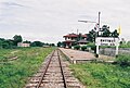 Suphan Buri Railway Station
 -
 Wat Pa Le Lai


References
- ^ "World Meteorological Organization Climate Normals for 1991–2020". World Meteorological Organization. Retrieved 12 October 2023.
- ^ "ปริมาณการใช้น้ำของพืชอ้างอิงโดยวิธีของ Penman Monteith (Reference Crop Evapotranspiration by Penman Monteith)" (PDF) (in Thai). Office of Water Management and Hydrology, Royal Irrigation Department. p. 73. Retrieved 4 August 2016.
- ^ "Climatological Data for the Period 1981–2010". Thai Meteorological Department. Retrieved 4 August 2016.
External links
 Suphanburi travel guide from Wikivoyage
14°28′3″N 100°07′01″E / 14.46750°N 100.11694°E
| International | |
|---|---|
| National | |