
Surveyor 1
This article needs additional citations for verification. (May 2020) |
 Surveyor model on Earth | |
| Mission type | Lunar lander |
|---|---|
| Operator | NASA |
| COSPAR ID | 1966-045A |
| SATCAT no. | 02185 |
| Mission duration | 7 months, 8 days (launch to last contact) |
| Spacecraft properties | |
| Manufacturer | Hughes Aircraft |
| Launch mass | 995.2 kilograms (2,194 lb)[1] |
| Landing mass | 292 kilograms (644 lb) |
| Start of mission | |
| Launch date | May 30, 1966, 14:41:01 UTC |
| Rocket | LC-36A |
| End of mission | |
| Last contact | 7 January 1967 |
| Lunar lander | |
| Landing date | June 2, 1966, 06:17:36 UTC[2] |
| Landing site | 2°28′26″S 43°20′20″W / 2.474°S 43.339°W[2] |
Surveyor 1 was the first
Surveyor 1 was launched May 30, 1966, from the
system.The Surveyor program was managed by the Jet Propulsion Laboratory, in Los Angeles County, California, and the Surveyor space probe was built by the Hughes Aircraft Company in El Segundo, California.
Mission description


The Surveyor series of
Surveyor 1 was launched May 30, 1966 and sent directly into a trajectory to the Moon without any
The duration of the
Surveyor 1 transmitted
The return of engineering information (temperatures, etc.) from Surveyor 1 continued through January 7, 1967, with several interruptions during the lunar nights.
The landing of Surveyor 1 was carried live on some television networks, and the success of the first Surveyor landing was considered surprising, especially after the failure of a number of the Ranger spacecraft en route to the Moon. Justin Rennilson, formerly of Jet Propulsion Laboratory, stated, "We figured the probability of success at around 10 to 15 percent." Among hundreds of other challenges, an uninterrupted communication link for navigation and control was critical to success.[4]
Science instruments
Television

The TV camera consisted of a
Each 600-line picture required about one second to be read from the vidicon tube, and they required a
-
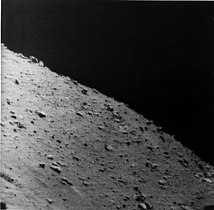
 Surveyor 1's shadow against the lunar surface (upside-down image)
 -
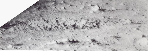
 The mare surface
 -
 Another view of the mare surface
 -
 Irregularly shaped crater at the landing site
 -
 Mottled rock about 50 cm long near Surveyor 1


Strain gauge
Strain gauges were mounted on each leg shock absorber to record the peak axial forces at landing impact of the spacecraft. They were designed to accept a force of approximately 800 kgf (7.8 kN).
Legacy and status
On January 6, 1967, Surveyor 1 was reactivated for 12 hours. The spacecraft returned data on the motion of the Moon, which would be used to refine the map of its orbital path around the Earth as well as better determine the distance between the two worlds.[7]
See also
References
- ^ "Surveyor 1". NASA's Solar System Exploration website. Retrieved December 2, 2022.
- ^ a b c "Surveyor 1". NASA Space Science Data Coordinated Archive. 2014-08-26. Retrieved 2015-06-01.
- ^ "Chandrayaan-2 landing: 40% lunar missions in last 60 years failed, finds Nasa report".
- ^ Pyle, Rod (2 June 2016). "Fifty Years of Moon Dust: Surveyor 1 was a Pathfinder for Apollo". NASA. Retrieved 12 March 2017.
- ^ NASA SP-184 - SURVEYOR Program Results (PDF). NASA. 1969. p. 109.
- ^ Montgomery, Wolf The Surveyor lunar landing television system. IEEE Spectrum, August 1966, p. 55-56
- ^ "Aeronautics and Astronautics, 1967" (PDF). NASA. p. 5. Retrieved 21 December 2021.
External links
- Surveyor 1 digitized panorama with color photometric target, from Surveyor Digitization Project
- Surveyor 1: 50 Years Later on YouTube
- Panoramas of the Surveyor 1 landing site, from The International Atlas of Lunar Exploration by Philip J. Stooke
- Surveyor Program Results (PDF) 1969
- Surveyor I – A Preliminary Report – June 1, 1966 (PDF)
- Surveyor I mission report. Part II – Scientific data and results – Sep 1966 (PDF)
- Details of Surveyor 1 launch, and also more on the Surveyor program
- Surveyor I images at Lunar and Planetary Institute
- Surveyor Site 1 Lunar Map at Lunar and Planetary Institute
- Surveyor Site 1 Lunar PhotoMap at Lunar and Planetary Institute
- Lunar Orbiter 1 photo 192, showing the northeastern part of Flamsteed P crater, where Surveyor 1 landed