
Taiping Island
| Disputed island | |
|---|---|
 Taiping Island | |
| Demographics | |
| Population | 220 military, coast guard and support personnel; 4 civilians[2] |

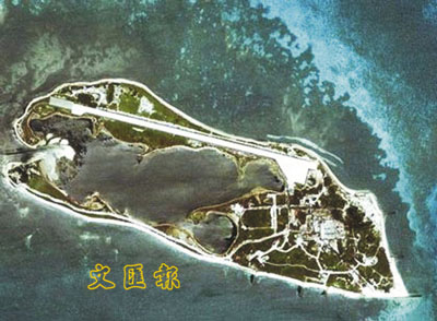
Taiping Island, also known as Itu Aba,[note 1] and various other names, is the largest of the naturally occurring Spratly Islands in the South China Sea.[3][4][5][6][note 2] The island is elliptical in shape being 1.4 kilometres (0.87 mi) in length and 0.4 kilometres (0.25 mi) in width, with an area of 46 hectares (110 acres). It is located on the northern edge of the Tizard Bank (Zheng He Reefs; 鄭和群礁). The runway of the Taiping Island Airport is easily the most prominent feature on the island, running its entire length.
The island is administered by the
In 2016, in the ruling by an arbitral tribunal in the
The adjacent unpopulated Zhongzhou Reef (Ban Than Reef) is also under the control of Taiwan.[11][12]
Names
In 1946, the
Outside of China and Taiwan, a common name for the island is Itu Aba, which was in use prior to 1946. Two different etymological origins have been proposed for this name: that it is a Malay expression meaning "What's that?" (conventionally spelled in Malay: Itu apa?, lit. 'What's that?'); or that it is a corruption of Hainanese: Widuabe (黃山馬).[17] Some Western sources including U.S. government publications continue to use "Itu Aba" as the primary designator of the land feature, often with "Taiping" in parentheses.
The Vietnamese name for the island is Ba Binh (Vietnamese: Đảo Ba Bình, lit. 'calm wave/sea island', chữ Hán: 島波平)[18][19] and the Philippine English name is Ligao Island (or in Filipino/Tagalog: Pulo ng Ligaw, lit. 'Island of Lost / Wild').
During the Japanese occupation of the island 1939–45, the name Nagashima (長島, Long Island) was used.[20]
History

From before the 1870s the island was used by fishermen from Hainan. They had a semi-permanent settlement. Supplies were shipped from Hainan to the island in exchange for turtle shells.[21]
China first asserted sovereignty in the modern sense to the South China Sea island when it formally objected to France's efforts to incorporate Itu Aba and other islands and rocks into
Sensing the weaknesses of the Republic of China, France formally incorporated the Paracel and Spratly islands into French Indochina in 1932, a year after the Japanese formally invaded northeast China (Manchuria). China and Japan both protested. On 6 April 1933,[22] France seized the Spratlys, formally included them in French Indochina, and built a couple of weather stations on them, but did not disturb the numerous Chinese fishermen it found there. On 3 July 1938,[22] French Indochinese colonial troops also formally occupied the Paracel islands in the name of French Indochina. The following year in March 1939, Japan took both the Paracel and Spratly islands from France, garrisoned them, and built a submarine base on Taiping (太平) Island. In 1941, the Japanese Empire made the Paracel and Spratly islands part of Taiwan, then under its rule.
In 1945, in accordance with the
After being secured by Nationalist China, the island was placed under the administration of China's
In 1952, a Philippine civilian began to mine sulfur from Taiping Island and that same year, a note attached to the Treaty of Taipei provided the Nationalist Chinese arguments for sovereignty over the island. The Nationalists established a permanent presence on the island in July 1956.[27]
From 2000, a detachment of the ROC
On 2 February 2008, ROC president
In February 2012, the ROC began construction of an antenna tower and associated facilities with the purpose of providing navigation assistance for aircraft landing. The tower had a planned height of approximately 7 to 8 metres (25'), and was scheduled to be completed in April 2012, and fully functional after proper testing in September 2012.[31] In July 2012, ROC authorities revealed a project which intended to extend the runway by 500 metres (660 yards), which would allow the island to accommodate various kinds of military aircraft.[32]
In late August 2013, the ROC government announced that it would spend US$112 million on upgrading the island's airstrip, and constructing a dock capable of allowing its 3,000-ton Coast Guard cutters to dock, due to be completed by 2016.[33]
On July 12, 2016, a tribunal of the
Geography
This section needs additional citations for verification. (August 2022) |


Ecology
The flora and fauna present on and surrounding the island include
Geology and landform
The island has a long and narrow shape that is low and flat, that is approximately 1,289.3 metres (1410 yards) long and 365.7 metres (400 yards) wide. The area of the north–south coastline is 41.3 hectares (102 acres), and the coastal vegetation line range is 36.6 hectares (90 acres). The mean tidewater over land area is approximately 49 hectares (120 acres), and during low sea tides the water reefs and land area is 98 hectares (250 acres), 4-6 metres (13' to 20') above sea level.
Since Taiping island is a coral island, the surface includes fine sand and coral reefs formed by weathering. Around the island are sandy beaches, with narrower beaches on the south and north sides 5 metres (16') wide, on the east side 20 metres (65') wide, and on the southwest side 50 metres (165') wide. The sand accumulated on the beach is rosy coloured, mainly formed from red coral fragments and shell debris.
A 523-metre long core sample was obtained by the CPC Corporation. The rock layers were estimated to be as old as 780,000 years at the 43-metre mark and over 2 million years past the 130-metre mark.[41]
Natural resources
The island has historically been mined for phosphates to the point of exhaustion, and today has no major natural resources. There is potentially a large amount of undiscovered reserves of oil and natural gas beneath surrounding waters within the South China Sea Basin, however, there has yet to be formal exploration and mining conducted.
Weather
Taiping Island has a tropical monsoon climate, with the temperature varying between 21 and 35 degrees Celsius (70 to 90°F). There is a strong southwest monsoon in summer months in June and July, with strong southwest wind and currents, and during the time typhoons become frequent there is abundant rainfall. The rainy season occurs during November and December.
Government and politics
The island, along with the rest of the Spratlys, is disputed by four countries on historical, geographic, legal and/or technical grounds, in pursuit of fishing rights, shipping lanes, and the potential of
Taiping Island is administered under the
Prior to 2012, the island's coast guard defense forces held 106 mm (4 in) recoilless guns and 81 mm (3 in) mortars. These were planned to be replaced by eight sets of 40 mm (2 in) auto-cannons and a number of 120 mm (5 in) mortars by the end of August 2012.[43]
Facilities
This section needs additional citations for verification. (March 2016) |
Taiping Island has four existing wells. The proportion of fresh water in them is 99.1, 75.8, 97.5, and 96.8 percent, respectively, averaging 92.3 percent. About 65 metric tons of water can be pumped from these wells daily to provide drinking water and meet cooking and everyday needs. Apart from well water, there are water-retaining facilities mainly used for farming.[44]
Since December 2014, the island has been powered by a 40 kWp photovoltaic power station with a 612 kW storage facility that will generate an estimated 50MWh per year. The project was divided into two phases: the first phase was completed in December 2011; and the second in December 2014. The entire solar power system will generate an estimated 189,492 kWh per year, saving an estimated 49,000 litres of diesel fuel per year. It was funded by the Ministry of Economic Affairs.[45]
The
Additional facilities located on the island include a shelter for fishermen, a
The ROC maintains a large meteorological station on Taiping island. The station collects weather information using surface instruments, launching weather balloons daily.
Guanyin Temple, built in 1959, and nearby tombstones dating back to the Qing dynasty (which lasted until 1911) can show traces of Chinese activity on the island.[48]
Coast guard
Three
Tourist attractions
A temple on the island exists as a common visiting place. The southeast side of the island contains old Japanese constructions. The "Taiping Cultural Park" (Chinese: 太平文化公園) is located near the pier. There is also a pillar erected on the island that declares Taiping Island as a territory of the Republic of China.[citation needed]
Sister cities
The following are sister cities with Taiping Island:
See also
- Pratas Island (Tungsha, Dongsha)
- List of islands of Taiwan
- List of maritime features in the Spratly Islands
- South China Sea Islands
- Taiping Island Airport
- Zhongzhou Reef
- List of Taiwanese superlatives
Notes
- ^ a b The feature is designated as ITU ABA ISLAND on NOAA chart K10
- ^ Note that from 2014 the PRC embarked on seven major reclamation projects in the Spratly Islands area. It appears that the largest of these are at Subi Reef and Mischief Reef. The reclamation at Fiery Cross Reef is of at least 60 hectares, and according to some unverifiable sources, possibly as large as 150 ha.[7]
References
- ^ "外交部と農業委員会、「太平島陸地生態環境調査団」説明会を開催" (in Japanese). 2016-01-25. Archived from the original on 2016-03-08. Retrieved 2016-02-02.
- ^ 護理師設籍南沙 創太平島首例
- ^ C. Michael Hogan (2011) South China Sea Topic ed. P.Saundry. Ed.-in-chief C.J.Cleveland. Encyclopedia of Earth. National Council for Science and the Environment. Washington DC
- ^ "Taiping Island". Spratly islands. Marine National Park Headquarters (Republic of China). Archived from the original on 4 March 2016. Retrieved 21 March 2014.
- ^ "Itu Aba – Inquirer Global Nation". Philippine Daily Inquirer. Retrieved 19 Aug 2014.
- ^ Michael Gold. "Taiwan Considers Permanent Armed Ships For Disputed South China Sea Island". Reuters. Retrieved 16 Oct 2014.
- ^ Kristine Kwok; Minnie Chan (2014-06-08). "China plans artificial island in disputed Spratlys chain in South China Sea". South China Morning Post. Retrieved 2014-09-28.
- ^ Tiezzi, Shannon (2016-07-13). "Taiwan: South China Sea Ruling 'Completely Unacceptable'". The Diplomat. Retrieved 2016-07-13.
- The Taipei Times. Retrieved 2016-07-13.
- ^ Chow, Jermyn (2016-07-12). "Taiwan rejects South China Sea ruling, says will deploy another navy vessel to Taiping". The Straits Times. Singapore Press Holdings Ltd. Co. Retrieved 2016-07-13.
- ISBN 9789814695565. Retrieved 31 October 2021.
- ^ 繆, 宇綸 (12 August 2016). "我在南海佔領中洲礁 太平島官兵定期巡視". Yahoo News. 中國廣播公司. Retrieved 31 October 2021.
- ^ ISBN 7220073313
- ^ "Itu Aba Island [Taiping Island], Spratly Islands". GlobalSecurity.org. 9 July 2011.
- ^ Soong, Grace, "Taiping Island camp shows sovereignty: Ma", The China Post, July 19, 2011.
- ^ Zhu Xianlong, "Commentary: Taiwan Independence No Easy Thing", People's Daily Online, August 14, 2002.
- ^ a b Pike, John (January 31, 2004). "Itu Aba Island [Taiping Island], Spratly Islands". GlobalSecurity.org. Archived from the original on February 9, 2004.
- ^ "VN demands a stop to violation of sovereignty", Vietnam+, May 10, 2012.
- ^ "Historical documents on Vietnam’s sovereignty over Paracel and Spratly islands Archived 2019-11-05 at the Wayback Machine", VietNamNet, June 24, 2011.
- ISBN 9839275100
- ^ Tizard Bank - Footnote, The China Sea Directory, Hydrographic Office - Admiralty, published by J D Potter, London 1879, page 66
- ^ a b Binoche, Jacques (1990). "La politique extrême-orientale française et les relations franco-japonaises de 1919 à 1939". Publications de la Société française d'histoire des outre-mers. 10 (1): 263–275.
- ISBN 978-9813231115.
- ^ Spratly Islands. Microsoft Encarta Online Encyclopedia 2008. Archived from the original on 2009-10-29.
- ^ "South China Sea: How we got to this stage". China Daily. July 6, 2018.
Signed on September 8, 1951 and entering into force on April 28, 1952, the document served to end the Allied post-war occupation of Japan and establish Japan's role in the international arena. It officially renounced Japan's rights to the land it occupied including "renounces all right, title and claim to the Spratly Islands and to the Paracel Islands". Its Article 2(6) provided that "Japan renounces all right, title and claim to the Spratly Islands (the Nansha Islands) and to the Paracel Islands (the Xisha Islands)", but did not specify the ownership of these islands.
- ^ "Taipei Peace Treaty". Retrieved 26 October 2014.
- ISBN 978-981431170-0.
- ^ "MND admits strategic value of Spratly airstrip." Taipei Times. 6 January 2006. p. 2 (MND is the ROC Ministry of National Defense)
- ^ Shih Hsiu-chuan, Hsu Shao-hsuan, and Jimmy Chuang. "President visits disputed islands." Taipei Times. 3 February 2008. p. 1.
- ^ Cindy Sui, 19 April 2011, Taiwan to boost forces in disputed Spratly Islands, BBC News
- ^ 6 February 2012, 太平島 將建助導航塔 Archived 2013-02-08 at the Wayback Machine, Liberty Times
- ^ July 15, 2012, Taiwan mulls extending runway in Spratlys: report, The West Australian [dead link]
- ^ 2013-09-02, Taiwan Plans New Infrastructure for Disputed South China Sea Claim, Voice of America
- ^ "Timeline: South China Sea dispute". Financial Times. 12 July 2016.
- ^ "A UN-appointed tribunal dismisses China's claims in the South China Sea". The Economist. 12 July 2016.
- ^ "South China Sea: Tribunal backs case against China brought by Philippines". BBC. 12 July 2016.
- ^ Perez, Jane (12 July 2016). "Beijing's South China Sea Claims Rejected by Hague Tribunal". The New York Times.
- ^ Jun Mai; Shi Jiangtao (12 July 2016). "Taiwan-controlled Taiping Island is a rock, says international court in South China Sea ruling". South China Morning Post.
- ^ "Our Island: The Atlas of Taiping Island of the Republic of China (Taiwan), Vol. 1" (PDF). Archived from the original (PDF) on 2019-08-30. Retrieved 2016-08-16.
- ^ "Introducing the Republic of China's Taiping Island" (PDF). 2015. Retrieved 2016-08-16.[permanent dead link]
- ^ 魏國彥 (2016-01-25). "名家觀點-太平島可能比台灣還老". 中時新聞網 (in Chinese).
- ^ 蕭照平, 3 May 2012, 太平島勘油軍艦護航?國防部:跟海巡署協調, China Times. (WebCite archive)
- ^ Joseph Yeh, 25 July 2012, Cannons and mortars to be deployed on Taiping in South China Sea: MND, The China Post (Taiwan)
- ^ "ROC Minister of the Interior Chen Wei-zen presides over a ceremony marking the opening of a wharf and lighthouse on Taiping Island" (Press release). Ministry of Interior (ROC, Taiwan). 12 December 2015. Retrieved 2016-01-13.
- ^ "Solar power system expanded on Taiping Island". Focus Taiwan. 14 December 2014.
- ^ "TAIPING ISLAND: AN ISLAND OR A ROCK UNDER UNCLOS". ASIA MARITIME TRANSPARENCY INITIATIVE. May 7, 2015.
- ^ "ROC to upgrade weather stations in disputed Spratlys". Government of the Republic of China. Archived from the original on 2015-04-02. Retrieved 2015-03-17.
- ^ "Taiping Island is an island, not a rock, and the ROC possesses full rights associated with an exclusive economic zone and continental shelf in accordance with UNCLOS". MOFA(ROC).
- ^ 添斌, 羅. "敦睦艦隊訪太平島 萬噸磐石艦首次錨泊". Liberty Times Net.
- ^ "InterLinc – City of Lincoln – Mayor's Dept Sister Cities". City of Lincoln, Nebraska. Archived from the original on 19 December 2013. Retrieved 24 December 2013.
External links
- Asia Maritime Transparency Initiative Island Tracker
- The International Portal of Taiping Island (Taiping Island – The Beautiful and Sustainable Island)
- Satellite image of Taiping Island by Google Maps
- Putative States in the Spratly Archipelago
- "Ecological Resources". Discovering the South China Sea. vm.nthu.edu.tw. Archived from the original on 2005-11-24.
- "Itu Aba Island". Discovering the South China Sea. vm.nthu.edu.tw. Archived from the original on 2006-02-09.
- paper.wenweipo.com Archived 2008-01-29 at the Wayback Machine – (Perhaps) Contains an undoctored 2008 satellite photo of the island Archived 2021-06-02 at the Wayback Machine showing the runway and (one) adjacent "standing area".
| Pratas Island | |
|---|---|
Amphitrite Group |
|
Crescent Group | |
| Other features | |
- List of maritime features in the Spratly Islands
- Great Wall of Sand
- Royal Malaysian Navy Offshore Bases
- Vietnamese DK1 rigs
- List of airports in the Spratly Islands
| Dangerous Ground |
| ||||||||
|---|---|---|---|---|---|---|---|---|---|
| West |
| ||||||||
| East | |||||||||
| South |
- Territorial disputes
- History of the Spratly Islands
- Nine-dash line
- Spratly Islands dispute
- Philippines and the Spratly Islands
- Battle of Leyte Gulf (1944)
- Battle of the Paracel Islands (1974)
- Southwest Cay incident(1975)
- Johnson South Reef Skirmish(1988)
- Scarborough Shoal standoff (2012)
- Designation of the West Philippine Sea (2012)
- Hai Yang Shi You 981 standoff (2014)
- Ships
- Airports
- Pratas Is
- Paracel Islands Airports
- Woody Is
- Spratly Islands Airports
- Itu Aba
- Spratly Is
- Swallow Reef
- Thitu Is
| Confrontations |
|
|---|---|
| Regions | |
| Occupied features | |
| Unoccupied features | |
| Related articles | |