
Tamaulipas
Tamaulipas | ||
|---|---|---|
State | ||
| Free and Sovereign State of Tamaulipas Libre y Soberano Estado de Tamaulipas (Spanish) | ||
|
Deputies[3] | ||
| Area Area code | ||
Ranked 10th | ||
| Website | Official Web Site | |
Tamaulipas (Spanish pronunciation:
It is located in northeast Mexico and is bordered by the states of
Etymology
The name Tamaulipas is derived from Tamaholipa, a Huastec term in which the tam- prefix signifies "place (where)". No scholarly agreement exists on the meaning of holipa, but "high hills" is a common interpretation.[9] Another explanation of the state name is that it is derived from Ta ma ho'lipam ("place where the Lipan Apache prey").
History
The area known as Tamaulipas has been inhabited for at least 8,000 years. Several different cultures (north coastal, south coastal, lowlands, and mountains) have come and gone during that period.
Tamaulipas was originally populated by the nomad Chichimec and sedentary Huastec, in addition to non-Chichimec hunter-gatherer and fishing tribes.
Spanish era
A gradual process was needed for Spain to subjugate the inhabitants of Tamaulipas in the 16th and 17th centuries. The first permanent
In 1784 Nuevo Santander (Tamaulipas) led by Escandón, annexed San Antonio de los Llanos and its dependencies on the Purificación lagoon together with a certain number of ranches on the right bank of the Río Grande that belonged to Nuevo León. New settlements were then founded and the line of towns along the Rio Grande would later be dubbed the "villas del norte," or northern towns (Laredo, Revilla [Guerrero], Mier, Camargo, and Reynosa) which were established as a key part of Escandón's plan for the pacification and colonization of the province. These settlements, from Laredo to Reynosa, served as a defensive line for larger centers of population in the Mexican interior. Moreover, the villas functioned as a means to introduce Spanish "civilization" to the indigenous groups of the area. The Tamaulipas-Nuevo Leon border likely runs along old Mesquite Posts.[10][11]
In the mid-17th century, various Apache bands from the Southern Plains, after acquiring horses from Europeans in New Mexico, moved southeastward into the Edwards Plateau, displacing the native hunting and gathering groups. One of these groups was known as Lipan (see Hodge 1907 Vol. I:769 for a confusing list of synonyms). After 1750, when most Apache groups of the Central Texas highlands were displaced by Comanche and moved into the coastal plain of southern Texas, the Europeans of the San Antonio area began referring to all Apache groups in southern Texas as Lipan or Lipan Apache.[12]
Many Indian groups of missions in southern Texas and northeastern Mexico had recently been displaced from their territory through the southward push by the Lipan Apaches and were still hostile toward Apaches, linking arms with the local Spanish authorities against their common foe.
By 1790, Europeans turned their attention from the aboriginal groups and focused on containing the Apache invaders. In northeastern Coahuila and adjacent Texas, Spanish and Apache displacements created an unusual ethnic mix. Here, the local Indians mixed with displaced groups from Coahuila and Chihuahua and Texas. Some groups, to escape the pressure, combined and migrated north into the Central Texas highlands.
Independent Mexico
In 1824, after the
.svg)
In 1840, it became a part of the short-lived
In the wake of the war, Tamaulipas remained an object of interest to
The
However, the years after Maximilian's defeat were ones of rebuilding and great growth in Tamaulipas.
Since the revolution of 1910, successive governments have dedicated themselves to building industry and infrastructure in Tamaulipas, including communications and educational systems. Norberto Treviño Zapata founded the state university system, as well as reformed the state oil industry. Marte Gómez provided increased farm sizes for private family farmers. And more recently, Emilio Martínez Manautou led industrial growth. Lately, a push has been to strengthen fishing, including efforts to increase the price of fish and shellfish on the international market.
During the 1970s,
Geography
This section needs additional citations for verification. (June 2023) |

The Tropic of Cancer crosses the southern part of the municipality of Victoria. The coastal plains along the Gulf have a large presence in the state, whereas inland the landscape is adorned by cactus species and pasture. Predominant fauna in the region include the cougar (Puma concolor), long-tailed weasel (Mustela frenata), ocelot (Leopardus pardalis), American badger (Taxidea taxus), North American beaver (Castor canadensis), plain chachalaca (Ortalis vetula) and quail.
In the western part of the state, the Sierra Madre Oriental displays warm valleys and high sierras with peaks reaching 3,280 m (10,760 ft) in the Pedragoso Sierra; 3,240 m (10,630 ft) in the Borregos Sierra; 3,220 m (10,560 ft) in La Gloria Sierra; 3,180 m (10,430 ft) in Cerro el Nacimiento; and 3,000 m (9,800 ft) above sea level in the Sierra el Pinal. The Sierra de Tamaulipas and the Sierra de San Carlos are isolated mountain ranges in eastern Tamaulipas.
In terms of hydrology, the Bravo, Purificacion, and Guayalejo Rivers flow into the Gulf of Mexico after crossing the state from the western inland. On their way, their basins and zones of influence naturally correspond to the areas destined for agricultural use. The Rio Grande, known to Mexicans as the
-
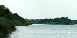 Falcon Reservoir, Municipality of Mier, Tamaulipas, Mexico (August 2007)
 -
 Thornscrub south of Reynosa, Municipality of Reynosa, Tamaulipas, Mexico (August 2007)
 -
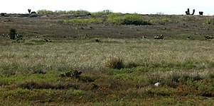 Grassland habitat on the road to Mezquital, Municipality of Matamoros, Tamaulipas, Mexico (March 2009)
 -
 Dawn on the Rio Sabinas near Highway 85, Municipality of Gómez Farías, Tamaulipas, Mexico (April 2001)
 -
 Road into the cloud forest of El Cielo Biosphere Reserve, Municipality of Gómez Farías, Tamaulipas, Mexico (April 2001)
 -
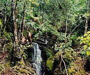 Lush cloud forest vegetation and waterfall in El Cielo Biosphere Reserve (August 2004).
 -
 The few roads in the cloud forest of El Cielo Biosphere Reserve are suitable for four-wheel drive vehicles only (August 2004).
 -
 Cloud forest stream in El Cielo Biosphere Reserve (August 2004)
 -
 Rio Guayalejo at Highway 80 with silhouette of Cerro del Bernal, Municipality of Gonzlaez, Tamaulipas, Mexico (April 2001)
 -
 Gravel road through the arid interior slopes of the Sierra Madre Oriental, Municipality of Miquihuana, Tamaulipas, Mexico (August 2003)
.jpg)
.jpg)
.jpg)
.jpg)
.jpg)


.jpg)
.jpg)
Climate
About 58% of the state has a hot
Government and infrastructure
This section needs expansion. You can help by adding to it. (December 2010) |
State agencies include:
- Secretaría de Seguridad Pública (Tamaulipas)
- Secretetaria De Obras Publica
- Procuraduria General De Justica Tamaulipas
- Policia Estatal
Economy

Northern Tamaulipas shares its economic culture with that of Texas, and is primarily characterized by agriculture and strong growth in all industrial sectors. This region is home to many of the maquiladoras, factories owned by foreign companies but worked by Mexicans, primarily by women. In the state there are important industrial parks such as the Oradel Industrial Center,[17] located in the border city of Nuevo Laredo.
Southern Tamaulipas' economy is primarily based on the
As of the 1990 Mexican census, 13 percent of the homes had only dirt floors, nearly 19 percent had no running water, and over 15 percent of the homes had no electricity. This was better than the national average but was skewed because of the high rate of development in the urban centers. In rural communities in Tamaulipas, access to running water was available in less than 40 percent of homes.
As of 2005, Tamaulipas's economy represents 3.3% of Mexico's total
Demographics
| Rank | Municipality | Pop. | |||||||
|---|---|---|---|---|---|---|---|---|---|
 Reynosa  Matamoros |
1 | Reynosa | Reynosa | 691,557 |  Nuevo Laredo  Ciudad Victoria | ||||
| 2 | Matamoros | Matamoros | 510,639 | ||||||
| 3 | Nuevo Laredo | Nuevo Laredo | 416,055 | ||||||
| 4 | Ciudad Victoria | Victoria | 332,100 | ||||||
| 5 | Tampico | Tampico | 297,373 | ||||||
| 6 | Ciudad Madero | Ciudad Madero | 205,933 | ||||||
| 7 | Miramar | Altamira | 161,820 | ||||||
| 8 | Río Bravo | Río Bravo | 111,314 | ||||||
| 9 | Ciudad Mante | El Mante | 79,515 | ||||||
| 10 | Altamira | Altamira | 79,824 | ||||||
| Year | Pop. | ±% |
|---|---|---|
| 1895[21] | 209,106 | — |
| 1900 | 218,948 | +4.7% |
| 1910 | 249,641 | +14.0% |
| 1921 | 286,904 | +14.9% |
| 1930 | 344,039 | +19.9% |
| 1940 | 458,832 | +33.4% |
| 1950 | 718,167 | +56.5% |
| 1960 | 1,024,182 | +42.6% |
| 1970 | 1,456,858 | +42.2% |
| 1980 | 1,924,484 | +32.1% |
| 1990 | 2,249,581 | +16.9% |
| 1995 | 2,527,328 | +12.3% |
| 2000 | 2,753,222 | +8.9% |
| 2005 | 3,024,238 | +9.8% |
| 2010 | 3,268,554 | +8.1% |
| 2015 | 3,441,698 | +5.3% |
| 2020[6] | 3,527,735 | +2.5% |
There is a large number of people (around 200 000 only in the city of Reynosa) born in the southern neighboring state of Veracruz who are economic immigrants that end up working in the maquila industry.[22]
Education
Tamaulipas enjoys standards slightly higher than the national averages, since illiteracy has been reduced to 5% for those over 15 years of age, average schooling reaches 7.8 years, and as many as 11% have earned a professional degree.
Institutions of higher education include:
- Instituto de Estudios Superiores de Tamaulipas(IEST)
- Instituto Tecnológico de Ciudad Madero (ITCM)
- Universidad Autónoma de Tamaulipas
- Tec Campus Tampico(ITESM)
Transportation
Airports
Tamaulipas is served by 5 international airports and one national airport.
- Ciudad Mante is served by: Ciudad Mante National Airport
- General Pedro J. Méndez International Airport
- General Servando Canales International Airport
- Quetzalcóatl International Airport
- Reynosa is served by: General Lucio Blanco International Airport
- General Francisco Javier Mina International Airport
Media
Newspapers of Tamaulipas include: El Bravo, El Diario de Ciudad Victoria, El Mañana, El Mañana de Reynosa, El Mercurio de Tamaulipas, El Sol de la Tarde, El Sol de Tampico, Hora Cero Tamaulipas, La Razón, La Tarde, La Verdad de Tamaulipas, Milenio, Periódico Valle del Norte, and Siempre con la verdad a tiempo.[23][24]
Notable natives and residents
- José Ángel Gurría Treviño, diplomat and economist, Secretary-General of the OECD.
- Intocable, Regional Mexican musical group
- Fito Olivares, Cumbia singer/musician
- Alicja Bachleda-Curus, actress, singer
- Rosemary Barkett, US judge
- Jean-Louis Berlandier (1803 – 1851) French-Mexican naturalist, physician, and anthropologist.
- James Carlos Blake, award-winning novelist
- José María Jesús Carbajal, Mexican freedom fighter, military governor of Tamaulipas
- Linda Christian, actress
- Ivan Contreras, volleyball olympics
- Ana Brenda Contreras, actress, singer
- Amalia González Caballero de Castillo Ledón, diplomat, cabinet minister, minister plenipotentiary, writer,
- Laura Elizondo, beauty queen/model
- Juan García Esquivel, composer/band leader/pianist
- Laura Flores, actress
- Manuel González Flores, general and politician who served as president of Mexico from 1880 to 1884.
- Víctor García, singer
- Elma González, plant cell biologist
- Rodrigo González, musician and songwriter
- Emilio Portes Gil, president of Mexico after the death of Alvaro Obregon in 1928.
- Alejandro Gomez Monteverde, director/producer
- Manuel Raga, basketball player
- Aurora Robles, model
- James de La Rosa, welterweight boxer
- The Contender
- Arleth Terán, actress
- Rigo Tovar, singer/songwriter/composer/actor
- Ismael Valdez, former starting pitcher in Major League Baseball
- Eduardo Verástegui, actor/model
- B. Traven, German author and activist[25]
- Juan Garcia Abrego, drug criminal
- Juan Nepomuceno Guerra, smuggler/founder of C.D.G.
- Mauricio Garces, actor
- Mayra Flores, politician, first Mexican-born American congressperson
State anthem
The current anthem of the state of Tamaulipas is Himno a Tamaulipas, composed in 1926 by Rafael Antonio Pérez Pérez, set to music by Alfredo Tamayo Marín. Normally, only the chorus, first verse and chorus are sung in public.
|
Coro: |
Chorus: |
|
Estrofa I: |
Verse I: |
|
Estrofa II: |
Verse II: |
|
Estrofa III: |
Verse III: |
|
Estrofa IV: |
Verse IV: |
|
Estrofa V: |
Verse V: |
|
Estrofa VI: |
Verse VI: |
Crime
This state is known to be the site of a territorial struggle between the Gulf Cartel and Los Zetas. The resulting deaths and unresolved kidnappings from the gang violence have been described as a "humanitarian tragedy".[27]
The state of Tamaulipas is one of the most affected by violence in the country, mainly caused by organized crime. In February 2010, an armed conflict broke out between the criminal groups known as the Gulf Cartel and Los Zetas, resulting in many border cities becoming "ghost towns"; such is the case of the border strip known as "La Frontera Chica" made up of the cities of Miguel Alemán, Mier, Camargo and Nueva Ciudad Guerrero.
In November 2010, the Mexican army, together with the Federal Police and the Navy, launched an operation around the north of the state of Tamaulipas, allowing hundreds of families to return to their homes after months of exile in other states, mainly in municipalities like Mier, where around 4,000 people returned.
According to INEGI, in 2012 Tamaulipas contained 9 municipalities with a homicide rate higher than 100 per 100,000 inhabitants: Cruillas (106), San Fernando (175), Llera (159), Mier (156), Güémez (141), Hidalgo (135), Nuevo Laredo (134), González (109) and Soto la Marina (100). On the other hand, the municipalities that had had the most intentional homicides in 2012 were Nuevo Laredo (536 homicides), Victoria (165) and San Fernando (102).
In 2013, 880 homicides were recorded in the state, giving a rate of 25 per 100,000 inhabitants. This placed it that year in the 9th position of the states with the most homicides in Mexico. In 2013, Tamaulipas reached the first national place in kidnappings with 275 known cases and the ninth place in violent highway robbery (68 cases).
As of 2021, Tamaulipas continues to be affected by violence, this being one of the factors that have greatly hindered the economic and social activity of the state. In 2014 it was estimated that the losses due to violence by each company in Tamaulipas reached an average of 95 thousand pesos per year (fourth highest in the country). This placed it above the national average in terms of cost of crime for each company (13,600 pesos against the national average of 12,800).[28]
See also
References
- ^ "Las Diputaciones Provinciales" (PDF) (in Spanish). p. 15. Archived (PDF) from the original on 2011-06-07.
- ^ "Senadores por Tamaulipas LXI Legislatura". Senado de la Republica. Archived from the original on September 24, 2015. Retrieved April 7, 2011.
- ^ "Listado de Diputados por Grupo Parlamentario del Estado de Tamaulipas". Camara de Diputados. Archived from the original on July 20, 2011. Retrieved April 7, 2011.
- ^ "Resumen". Cuentame INEGI. Archived from the original on May 11, 2013. Retrieved February 12, 2013.
- ^ "Relieve". Cuentame INEGI. Archived from the original on June 18, 2010. Retrieved April 7, 2011.
- ^ a b "México en cifras". January 2016. Archived from the original on 2021-07-18. Retrieved 2021-01-25.
- ^ Citibanamex (June 13, 2023). "Indicadores Regionales de Actividad Económica 2023" (PDF) (in Spanish). Retrieved August 13, 2023.
- ^ "Tamaulipas" (PDF). SRE. Archived (PDF) from the original on April 21, 2011. Retrieved April 7, 2011.
- ^ "Historia". Gobierno del Estado de Tamaulipas. Archived from the original on December 23, 2010. Retrieved April 7, 2011.
- ISBN 9789686361162. Retrieved July 7, 2022.
- ISBN 9788484551058. Retrieved July 7, 2022.
- ^ (Campbell and Campbell 1981:62–64).
- ^ Howe, Daniel Walker. What Hath God Wrought: The Transformation of America, 1815-1848. Oxford University Press, 2007. p.801-804
- ^ McPherson, James M. Battle Cry of Freedom: The Civil War Era. Oxford University Press, 2003. p.105
- ^ Hart, John Mason. Empire and Revolution: The Americans in Mexico since the Civil War. University of California Press, 2002. p.24
- ^ a b c d "Clima" [Climate] (in Spanish). INEGI. Archived from the original on 17 June 2019. Retrieved 17 June 2019.
- ^ La Razón (2018-08-20). "Gobernador de Tamaulipas inaugura la nave del Parque Industrial Oradel". https://www.razon.com.mx/mexico/gobernador-de-tamaulipas-inaugura-la-nave-del-parque-industrial-oradel/. Archived from the original on 2019-07-09. Retrieved 2019-07-09.
{{cite journal}}: External link in|journal= - ^ "Puerto de Tampico". Ports in Mexico. World Port Source. Archived from the original on 2009-10-19. Retrieved 2009-12-17.
- ^ a b Industrial Costs in Mexico – A Guide for Foreign Investors 2007. Mexico City: Bancomext. 2007. p. 102.
- ^ "Censo Tamaulipas 2020".
- ^ "Mexico: extended population list". GeoHive. Archived from the original on 2012-03-11. Retrieved 2011-07-29.
- ^ "Baja migración de veracruzanos hacia Reynosa". 23 February 2017. Archived from the original on 2020-08-18. Retrieved 2019-11-25.
- ^ "Publicaciones periódicas en Tamaulipas". Sistema de Información Cultural (in Spanish). Gobierno de Mexico. Archived from the original on August 7, 2020. Retrieved March 7, 2020.
- ^ "Latin American & Mexican Online News". Research Guides. US: University of Texas at San Antonio Libraries. Archived from the original on March 7, 2020.
- ^ Tapio, Helen. "B. Traven's Identity Revisited". Helsinki Historia. Historical Association. Archived from the original on 12 January 2017. Retrieved 17 June 2016.
- ^ "HIMNO A TAMAULIPAS". Archived from the original on 2011-07-07. Retrieved 2012-09-17.
- ^ "Impone EU 'toque de queda' a sus empleados consulares por narcoviolencia en Tamaulipas - Proceso". proceso.com.mx. 4 January 2015. Archived from the original on 12 December 2017. Retrieved 2 May 2018.
- ^ "El Financiero(Lauman Multimedia Group, SAPI de CV). Integralia". 2014. Archived from the original on 2018-01-01. Retrieved 2021-04-13.
External links
 Geographic data related to Tamaulipas at OpenStreetMap
- Tamaulipas state government (in Spanish)
- Ley de Escudo de Armas y el Himno de Tamaulipas

| International | |
|---|---|
| National | |
| Geographic | |