
Taralga
| Taralga Federal division(s) | Hume | ||||||||||||||
|---|---|---|---|---|---|---|---|---|---|---|---|---|---|---|---|
| |||||||||||||||
| |||||||||||||||
Taralga is the traditional land of the Gundungurra people. Today it is a small village in the
The population of Taralga has fluctuated over time reflecting the town's fortunes. There were approximately 100 residents in 1863, growing to over 700 by the 1890s. Immediately after the depression of the 1890s, the population shrank to half this size, but recovered by the mid-1950s almost to its peak level. Today the town and its surroundings are home to around 400 people.[2]
Naming
The exact origin of the name Taralga is disputed. The two most widely supported theories are that the village was originally known as "Trial Gang" as within the early colonial boundaries of
A newspaper editorial in 1886 suggests the word Taralga is a corruption of 'Trialgong', an Indigenous word for 'three stony hills' (presumably in the Burra language), rather than a corruption of 'Trial gang'.[4] Also, explorer Thomas Mitchell mentioned 'Trialgong creek' in his field, note and sketchbook in 1828.[5]
History
The area around Taralga was the traditional land of the Burra Burra peoples of the Gundungurra Nation.[citation needed]. Although no major clashes with the Europeans seem to have been recorded, nor tales of collaboration with them, their last great gathering or corroboree seems to have been in the 1830s after which they are not recorded by European history. Accordingly, they would have been pushed further west to less fertile plains after the disease brought by the Europeans.
An 1828 census revealed a small number of residents at Taralga suggesting the village was already under way by that time, although there were probably no more than a few buildings.[7] For the first few decades of the colony of New South Wales, most of the settlers were convicts assigned to the landowners and it was they who largely cleared the land, built the huts and houses, and ran the farms. Taralga started to look like a town after the first few houses were built in the 1840s, but more rapid growth would be experienced in the 1860s in part due to the Robertson Land Acts allowing freehold title over land to settlers at favourable rates.[8]
Taralga was officially established as a town in the 1860s, with a school in 1857, and churches—

In 1923, the town was visited by Premier Sir George Fuller, marking a period of renewed interest and prosperity in Taralga. During that visit, the Premier unveiled a war memorial honouring those residents who served in World War I, turned the first sod for construction of a railway link, and laid the foundation stone for the Taralga Co-Operative Dairy Company's new butter factory.[9] The 25 km (16 mi) Taralga railway line, constructed as a branch from the Crookwell line at Roslyn, opened in 1926 and closed in 1957. The line has since been lifted and little remains of the formation.[10] Electricity was first provided in the 1930s by way of a plant set up by a local, Sid Holt.[2]
Heritage listings
Taralga has a number of heritage-listed sites, including:
- Macarthur Street: Catholic Church of Christ the King[11]
Taralga today

While the population of Taralga declined after the gold rush period, the character of the town did not. Today there are many historically significant buildings to be observed throughout the town. Small vineyards are located around the town. There are two heritage listed hotels, and a sports club with lawn bowling greens and tennis courts. There is a 9-hole golf course with sand greens. The town also hosts the annual "Australia Day Rodeo" and the Taralga Tigers Rugby Club always attracts big crowds during the Winter months and in the summer touch football is played.
The town is situated on the
Taralga Wind Farm
On 20 February 2012, approval was granted by the
Taralga Wildlife Park
There is a small wildlife park in Taralga that is keeps a number of native and domestic species including bare-nosed wombats, eastern grey kangaroos, hill wallaroos, red-necked wallabies, dingoes, dromedary camel, llama (including hybrid llama-guanaco), alpacas, donkey, miniature horses, fallow deer, blackbuck, eastern bearded dragon, blotched blue-tongued lizards, shingleback lizards, spiny-tailed skinks, wedge-tailed eagle, tawny frogmouth, laughing kookaburra, channel-billed cuckoos, blue-and yellow macaw, cockatoos (sulphur-crest, pink, yellow-tailed black, red-tailed black & gang-gang), parrots, black swans, geese, ducks, royal spoonbill, glossy ibis, helmeted guineafowl, pheasants, turkeys and others.
Climate
Taralga has an
The lowest maximum temperature was 1.1 °C (34.0 °F) recorded in August 1962; the highest temperature recorded was 40.5 °C (104.9 °F) in January 2020. The lowest minimum plummeted to −9.6 °C (14.7 °F) in July 1982; and the highest minimum on record was 24.2 °C (75.6 °F) in February 1973.[14]
| Climate data for Taralga Post Office (1955–2022, rainfall to 1882); 845 m AMSL; 34.40° S, 149.82° E | |||||||||||||
|---|---|---|---|---|---|---|---|---|---|---|---|---|---|
| Month | Jan | Feb | Mar | Apr | May | Jun | Jul | Aug | Sep | Oct | Nov | Dec | Year |
| Record high °C (°F) | 40.5 (104.9) |
40.2 (104.4) |
36.3 (97.3) |
31.0 (87.8) |
25.7 (78.3) |
21.5 (70.7) |
19.3 (66.7) |
22.4 (72.3) |
27.5 (81.5) |
30.5 (86.9) |
38.5 (101.3) |
39.5 (103.1) |
40.5 (104.9) |
| Mean daily maximum °C (°F) | 26.3 (79.3) |
24.9 (76.8) |
22.5 (72.5) |
18.7 (65.7) |
14.5 (58.1) |
11.2 (52.2) |
10.4 (50.7) |
11.9 (53.4) |
15.1 (59.2) |
18.5 (65.3) |
21.5 (70.7) |
24.5 (76.1) |
18.3 (64.9) |
| Mean daily minimum °C (°F) | 12.1 (53.8) |
12.1 (53.8) |
9.9 (49.8) |
6.2 (43.2) |
3.2 (37.8) |
1.7 (35.1) |
0.6 (33.1) |
1.2 (34.2) |
3.1 (37.6) |
5.4 (41.7) |
7.8 (46.0) |
9.9 (49.8) |
6.1 (43.0) |
| Record low °C (°F) | 1.1 (34.0) |
1.2 (34.2) |
−1.1 (30.0) |
−4.0 (24.8) |
−6.5 (20.3) |
−7.8 (18.0) |
−9.6 (14.7) |
−7.3 (18.9) |
−6.0 (21.2) |
−4.8 (23.4) |
−2.5 (27.5) |
−0.2 (31.6) |
−9.6 (14.7) |
| Average precipitation mm (inches) | 73.4 (2.89) |
71.9 (2.83) |
70.1 (2.76) |
58.1 (2.29) |
59.0 (2.32) |
75.3 (2.96) |
66.4 (2.61) |
68.0 (2.68) |
61.3 (2.41) |
69.9 (2.75) |
69.5 (2.74) |
66.4 (2.61) |
804.0 (31.65) |
| Average precipitation days (≥ 0.2 mm) | 9.3 | 9.3 | 9.4 | 8.6 | 9.8 | 12.4 | 12.1 | 11.4 | 10.1 | 9.9 | 9.2 | 8.9 | 120.4 |
| Source: Bureau of Meteorology[14] | |||||||||||||
Gallery
-
 Taralga c1900
 -
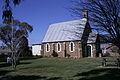 Taralga Church
 -
 Taralga Catholic Church
 -
 Taralga Main Street
 -
 Taralga Main Street
.jpg)


See also
References
- ^ a b Australian Bureau of Statistics (27 June 2017). "Taralga (State Suburb)". 2016 Census QuickStats. Retrieved 7 July 2017.
- ^ Upper Lachlan Shire Council. Retrieved 20 January 2013.
- ^ McInnes, Peter (2022). "A dance of brolgas? The meaning of Taralga" (PDF). Australia National Placename Survey. Retrieved 13 November 2023.
- ^ "TARALGA". Australian Town and Country Journal. Vol. XXXIII, no. 846. New South Wales, Australia. 27 March 1886. p. 17. Retrieved 3 September 2020 – via National Library of Australia.
- ^ Mitchell, Thomas. "Sir T. L. Mitchell's field, note & sketchbook, 1828-1830". Mitchell Library. State Library of New South Wales.
- ^ Heydon, J D. "Macarthur, James (1798 - 1867)". Australian Dictionary of Biography. Australian National University. Retrieved 21 February 2007.
- ^ "Mulwaree Shire Community Heritage Study, 2002 - 2004" (PDF). Goulburn Mulwaree Council. Archived from the original (pdf) on 19 September 2006. Retrieved 5 February 2007.
- ^ "Taralga". Towns and Villages of the Southern Tablelands NSW. Retrieved 20 January 2013.
- ^ "Taralga War Memorial". War Memorials in Australia. Retrieved 20 January 2013.
- ^ Bozier, Rolfe; et al. "Taralga Line". NSWrail.net. Retrieved 5 May 2007.
- .
- ^ "Taralga Wind Farm". Renewable Energy Systems Ltd. Retrieved 20 January 2013.
- ^ Peel, Jacqueline. "Taralga Landscape Guardians case (2007)". University of Melbourne. Retrieved 20 January 2013.
- ^ a b "Climate statistics for Taralga". Bureau of Meteorology. Retrieved 24 April 2020.
External links
![]() Media related to Taralga, New South Wales at Wikimedia Commons
Media related to Taralga, New South Wales at Wikimedia Commons
| Towns | |
|---|---|
| Localities and rural places |
|
Main Article: Local government areas of New South Wales | |