
Taymyr Peninsula
Таймырский полуостров | |
|---|---|
 Location of the Taymyr Peninsula. | |
 | |
| Geography | |
| Location | Far North |
| Coordinates | 74°N 98°E / 74°N 98°E |
| Adjacent to | |
| Area | 400,000 km2 (150,000 sq mi) |
| Length | 1,050 km (652 mi) |
| Width | 520 km (323 mi) |
| Highest elevation | 1,125 m (3691 ft) |
| Highest point | Byrranga Mountains |
| Administration | |
| Federal subject | Krasnoyarsk Krai |
The Taymyr Peninsula (
Geography
The Taymyr Peninsula lies between the
.Lake Taymyr and the Byrranga Mountains are located within the vast Taymyr Peninsula.
Population
The
The
Economy
Ecology
-
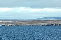 Cape Chelyuskin, northernmost point of Russian and of Afro-Eurasian mainland; 77°43’22’’N, 104°15’13’’E
 -
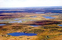 Taymyr landscape
 -
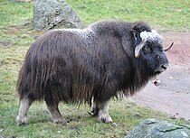 Bovidae, successfully reintroduced to the Taymyr Peninsula region in 1975


The peninsula is the site of the last known naturally occurring muskox outside of North America, which died out about 2,000 years ago.[3] They were successfully reintroduced in 1975.[4] The population grew to 2,500 in 2002 increasing to 6,500 in 2010.[5]
Study in 2021 found that based on
Climate
The coasts of the Taymyr Peninsula are frozen most of the year, between September and June on average. The summer season is short, especially on the shores of the Laptev Sea in the northeast. The climate in the north and exterior of the peninsula is Tundra Climate (ET), while some areas further-south have a very cold but somewhat more continental subarctic climate, with winters even slightly colder than the tundra directly to the north, but with somewhat warmer summers that can support some tree growth. Winters are harsh, with frequent blizzards and extremely low temperatures. The following data for Cape Chelyuskin provides an indication of the weather experienced in the northern part of the peninsula.
| Climate data for Cape Chelyuskin | |||||||||||||
|---|---|---|---|---|---|---|---|---|---|---|---|---|---|
| Month | Jan | Feb | Mar | Apr | May | Jun | Jul | Aug | Sep | Oct | Nov | Dec | Year |
| Mean daily maximum °C (°F) | −26 (−15) |
−26 (−15) |
−24 (−11) |
−16 (3) |
−8 (18) |
1 (34) |
5 (41) |
4 (39) |
0 (32) |
−10 (14) |
−19 (−2) |
−22 (−8) |
−12 (11) |
| Mean daily minimum °C (°F) | −33 (−27) |
−33 (−27) |
−33 (−27) |
−26 (−15) |
−15 (5) |
−5 (23) |
−3 (27) |
−3 (27) |
−5 (23) |
−16 (3) |
−26 (−15) |
−30 (−22) |
−19 (−2) |
| Average precipitation mm (inches) | 8 (0.3) |
9 (0.4) |
9 (0.4) |
8 (0.3) |
9 (0.4) |
18 (0.7) |
21 (0.8) |
22 (0.9) |
22 (0.9) |
15 (0.6) |
9 (0.4) |
11 (0.4) |
201 (7.9) |
| Average precipitation days | 15 | 15 | 14 | 12 | 11 | 12 | 11 | 12 | 15 | 16 | 13 | 16 | 162 |
| Mean monthly sunshine hours | 0 | 0 | 124 | 270 | 217 | 150 | 186 | 124 | 62 | 0 | 0 | 0 | 1,133 |
| Source: World Climate Guide[7] | |||||||||||||
See also
References
- ^ Ziker
- ^ Hoppál 2005
- ^ BioMed Central (6 October 2005). "Muskox Suffered Loss Of Genetic Diversity At Pleistocene/Holocene Transition" – via Science Daily.
- ^ "Greenland Muskox". Bovids. Safari Club International. Archived from the original on 2007-09-27.
- ^ Dr. Taras Sipko. "Reintroduction of Musk Ox in the Northern Russia". Large Herbivore Network. Archived from the original on 2015-09-05.
- PMID 34671161.
- ^ "Climate Data for Mys Chelyuskin". World climate Guide. Retrieved April 1, 2012.
Bibliography
- Hoppál, Mihály (2005). Sámánok Eurázsiában (in Hungarian). Budapest: Akadémiai Kiadó. ISBN 9630582953. (The title means “Shamans in Eurasia”, the book is written in Hungarian, but it is published also in German, Estonian and Finnish: Site of publisher with short description on the book (in Hungarian) Archived 2010-01-02 at the Wayback Machine.)
External links
| International | |
|---|---|
| National | |