
Tekezé River
| Tekezé River | |
|---|---|
 | |
 Tekezé-Senit River Watershed (Interactive map) | |
| Location | |
| Countries | |
| Physical characteristics | |
| Source | Ethiopian Highlands |
| • location | Birkumit, Ethiopia |
| • coordinates | 12°05′13″N 39°20′17″E / 12.087°N 39.338°E |
| • elevation | 3,110 m (10,200 ft) |
| Mouth | Atbarah River |
• location | near Wad Muzammil, Eritrea / Ethiopia / Sudan border |
• coordinates | 14°20′N 36°51′W / 14.34°N 36.85°W |
• elevation | 540 m (1,770 ft) |
| Length | 608 km (378 mi) |
| Basin size | 64,210 km2 (24,790 sq mi) |
| Basin features | |
| Progression | Atbarah River → Nile → Mediterranean Sea |
| River system | Nile |
The Tekezé or Täkkäze River (
Course
The Tekezé River rises in the central
The names of its main tributaries in Ethiopia from its source are: on the right bank Tahali, Meri, Tellare, Sullo, Arekwa, Gheoa, Wari, Firafira, Tocoro, and Gumalo Rivers; on the left bank Nili, Balagas, Saha, Bembea, Ataba, Zarima, and Kwalema Rivers.
History
The earliest known mention of the Tekezé is in an inscription from Aksum of king Ezana of Axum, where he boasts of a victory in a battle on its lower banks, near "the ford of Kemalke".[6] The Tekezé served as an early link between Ethiopia and Egypt; for example, the Kebra Nagast, which received its current form in the 13th century, states that king Menelik I returned to Ethiopia by following this river from Egypt (ch. 53). Augustus B. Wylde records a related tradition that near the source of the Tekezé, at the location of Eyela Kudus Michael church, is the true resting-place of the Ark of the Covenant.[7]
Between February and March 1936, during the
On 1 July 2021, the bridge crossing the Tekezé river was destroyed during the Tigray War. The International Rescue Committee was concerned that the humanitarian aid efforts in the region would be "even more severely hampered than before."[9]
Tekezé Dam
The Ethiopian government announced in July 2002 that they had formed a partnership with the
The Tekeze Hydro Electric project constructed the highest double curve arch dam in Africa, topping the previous highest, in Lesotho. The contractors behind the project were CWGS and it was completed in 2009. The resulting reservoir is 105 km2 large and it has a capacity of 9.3 billion m³ of water.[12]
Gallery
-
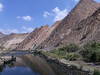 Tekezé gorge, a few km downstream from the reservoir
 -
 A crocodile along the Tekezé River
 -
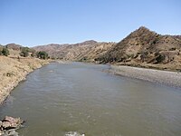 A crossing at the Tekezé
 -
 "A view of the mountains of Samen & the River Tacazze", by Henry Salt and Charles Heath (1814)
 -
 Unknown person sitting next to a killed crocodile, 1881
 -
 Tekeze bridge, 2017


See also
Notes
- ^ Ritler, Alfons. 2010. "Täkkäze." In Encyclopaedia Aethiopica: O-X: Vol. 4, edited by Siegbert Uhlig, 823-825. Wiesbaden: Harrassowitz.
- ISBN 0-87779-446-4, p. 1,194.
- ^ "Climate, 2012 National Statistics (Abstract)"[permanent dead link], Table A.2. Central Statistical Agency website (accessed 25 October 2015)
- ^ "Ethiopia's Water Dilemma" (PDF). Archived from the original (PDF) on 2007-02-08.
- ^ Eritrea - Ethiopia Boundary Commission Decision Regarding Delimitation of the Border..., pp. 97, 101
- ^ Translated with commentary in G.W.B. Huntingford, The Historical Geography of Ethiopia (London: British Academy, 1989), pp. 56-59.
- ^ Augustus B. Wylde, Modern Abyssinia (London: Methuen, 1901), p. 352
- ^ Barker, A. J., The Rape of Ethiopia 1936, New York: Ballantine Books Inc., 1971, pp. 84, 91.
- ^ "Bridge on Tekeze River in Ethiopia's Tigray destroyed - aid group". Reuters. 2021-07-01. Retrieved 2021-07-14.
- ^ China People's Daily Online. Accessed 20 April 2006.
- Walta Information Center), accessed 2 December 2007.
- ^ ANNYS, Sofie; GHEBREYOHANNES, Tesfaalem; NYSSEN, Jan. Impact of hydropower dam operation and management on downstream hydrogeomorphology in semi-arid environments (Tekeze, Northern Ethiopia). Water, 2020, 12.8: 2237.
External links
- Maps of Ethiopia - Perry–Castañeda Library Map Collection, University of Texas at Austin
| Authority control databases: National |
|---|