
Teller County, Colorado
Teller County | |
|---|---|
 Teller County Court House in Cripple Creek | |
|
UTC−6 (MDT) | |
| Congressional district | 5th |
| Website | www |
Teller County is a
2020 census, the population was 24,710.[1] The county seat is Cripple Creek,[2] and the most populous city is Woodland Park
.
Teller County is included in the Colorado Springs, CO Metropolitan Statistical Area.
History
A few years after gold was discovered in
Henry M. Teller. Within five years of its formation, Teller County became the scene of a dramatic labor struggle called the Colorado Labor Wars
.
Geography
According to the
U.S. Census Bureau, the county has a total area of 559 square miles (1,450 km2), of which 557 square miles (1,440 km2) is land and 1.9 square miles (4.9 km2) (0.3%) is water.[4]
Adjacent counties
- Douglas County - north
- Jefferson County - north
- El Paso County - east
- Fremont County - south
- Park County - west
Major highways
- U.S. Highway 24
 State Highway 67
National protected areas
- Cripple Creek National Historic District
- Florissant Fossil Beds National Monument
- Pike National Forest
State protected area
Trails and byways
- American Discovery Trail
- Gold Belt Tour National Scenic and Historic Byway
Historic places
Demographics
| Census | Pop. | Note | %± |
|---|---|---|---|
| 1900 | 29,002 | — | |
| 1910 | 14,351 | −50.5% | |
| 1920 | 6,696 | −53.3% | |
| 1930 | 4,141 | −38.2% | |
| 1940 | 6,463 | 56.1% | |
| 1950 | 2,754 | −57.4% | |
| 1960 | 2,495 | −9.4% | |
| 1970 | 3,316 | 32.9% | |
| 1980 | 8,034 | 142.3% | |
| 1990 | 12,468 | 55.2% | |
| 2000 | 20,555 | 64.9% | |
| 2010 | 23,350 | 13.6% | |
| 2020 | 24,710 | 5.8% | |
| 2023 (est.) | 24,617 | [5] | −0.4% |
| U.S. Decennial Census[6] 1790-1960[7] 1900-1990[8] 1990-2000[9] 2010-2020[1] | |||
At the
racial makeup of the county was 94.92% White, 0.55% Black or African American, 0.97% Native American, 0.58% Asian, 0.08% Pacific Islander, 0.90% from other races, and 2.00% from two or more races. 3.49% of the population were Hispanic or Latino of any race.[10]
Of the 7,993 households 33.60% had children under the age of 18 living with them, 64.20% were married couples living together, 6.60% had a female householder with no husband present, and 25.90% were non-families. 19.60% of households were one person and 4.00% were one person aged 65 or older. The average household size was 2.56 and the average family size was 2.94.
The age distribution was 25.90% under the age of 18, 5.60% from 18 to 24, 31.20% from 25 to 44, 29.80% from 45 to 64, and 7.50% 65 or older. The median age was 39 years. For every 100 females there were 102.70 males. For every 100 females age 18 and over, there were 100.90 males.
The
poverty line
, including 6.90% of those under age 18 and 4.20% of those age 65 or over.
Politics
| Year | Republican | Democratic | Third party | |||
|---|---|---|---|---|---|---|
| No. | % | No. | % | No. | % | |
| 2020 | 11,241 | 66.36% | 5,278 | 31.16% | 420 | 2.48% |
| 2016 | 9,745 | 67.47% | 3,603 | 24.94% | 1,096 | 7.59% |
| 2012 | 8,702 | 64.59% | 4,333 | 32.16% | 438 | 3.25% |
| 2008 | 8,146 | 63.12% | 4,513 | 34.97% | 247 | 1.91% |
| 2004 | 8,094 | 68.35% | 3,556 | 30.03% | 192 | 1.62% |
| 2000 | 6,477 | 65.78% | 2,750 | 27.93% | 620 | 6.30% |
| 1996 | 4,458 | 57.93% | 2,312 | 30.05% | 925 | 12.02% |
| 1992 | 3,050 | 44.11% | 1,873 | 27.09% | 1,991 | 28.80% |
| 1988 | 3,760 | 68.36% | 1,656 | 30.11% | 84 | 1.53% |
| 1984 | 3,460 | 75.84% | 1,043 | 22.86% | 59 | 1.29% |
| 1980 | 2,457 | 66.28% | 802 | 21.63% | 448 | 12.09% |
| 1976 | 1,410 | 55.93% | 986 | 39.11% | 125 | 4.96% |
| 1972 | 1,440 | 70.45% | 535 | 26.17% | 69 | 3.38% |
| 1968 | 722 | 52.39% | 403 | 29.25% | 253 | 18.36% |
| 1964 | 577 | 45.65% | 685 | 54.19% | 2 | 0.16% |
| 1960 | 723 | 53.60% | 622 | 46.11% | 4 | 0.30% |
| 1956 | 977 | 66.42% | 494 | 33.58% | 0 | 0.00% |
| 1952 | 1,042 | 63.89% | 572 | 35.07% | 17 | 1.04% |
| 1948 | 748 | 48.35% | 779 | 50.36% | 20 | 1.29% |
| 1944 | 829 | 50.24% | 808 | 48.97% | 13 | 0.79% |
| 1940 | 1,268 | 37.60% | 2,084 | 61.80% | 20 | 0.59% |
| 1936 | 940 | 27.91% | 2,349 | 69.74% | 79 | 2.35% |
| 1932 | 752 | 30.21% | 1,534 | 61.63% | 203 | 8.16% |
| 1928 | 1,184 | 52.04% | 1,037 | 45.58% | 54 | 2.37% |
| 1924 | 1,283 | 48.78% | 592 | 22.51% | 755 | 28.71% |
| 1920 | 1,552 | 57.89% | 1,010 | 37.67% | 119 | 4.44% |
| 1916 | 1,693 | 31.00% | 3,515 | 64.37% | 253 | 4.63% |
| 1912 | 676 | 11.64% | 3,027 | 52.11% | 2,106 | 36.25% |
| 1908 | 3,014 | 40.45% | 4,192 | 56.26% | 245 | 3.29% |
| 1904 | 5,595 | 55.51% | 4,398 | 43.63% | 87 | 0.86% |
| 1900 | 4,738 | 32.51% | 9,659 | 66.27% | 178 | 1.22% |
Communities
Cities
Town
- Green Mountain Falls (partly in El Paso County)
Census-designated places
Unincorporated communities
Gallery
-
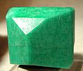 Amazonite crystal, from Crystal Peak area near Florissant
 -
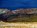 Mountains in Teller County
 -
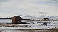 A ranch home with an airplane in the county
 -
 Casinos in Cripple Creek
 -
 Dome Rock, Mueller State Park


See also
- Bibliography of Colorado
- Geography of Colorado
- History of Colorado
- Index of Colorado-related articles
- List of Colorado-related lists
- Outline of Colorado
- Front Range Urban Corridor
References
- ^ a b "State & County QuickFacts". United States Census Bureau. Retrieved September 5, 2021.
- ^ "Find a County". National Association of Counties. Retrieved June 7, 2011.
- ^ Elizabeth Jameson, All That Glitters—Class, Conflict, and Community in Cripple Creek, 1998, page 168.
- ^ "US Gazetteer files: 2010, 2000, and 1990". United States Census Bureau. February 12, 2011. Retrieved April 23, 2011.
- ^ "Annual Estimates of the Resident Population for Counties: April 1, 2020 to July 1, 2023". United States Census Bureau. Retrieved March 31, 2024.
- ^ "U.S. Decennial Census". United States Census Bureau. Retrieved June 11, 2014.
- ^ "Historical Census Browser". University of Virginia Library. Retrieved June 11, 2014.
- ^ "Population of Counties by Decennial Census: 1900 to 1990". United States Census Bureau. Retrieved June 11, 2014.
- ^ "Census 2000 PHC-T-4. Ranking Tables for Counties: 1990 and 2000" (PDF). United States Census Bureau. Archived (PDF) from the original on March 27, 2010. Retrieved June 11, 2014.
- ^ "U.S. Census website". United States Census Bureau. Retrieved May 14, 2011.
- ^ Leip, David. "Dave Leip's Atlas of U.S. Presidential Elections". uselectionatlas.org. Retrieved May 26, 2017.
External links
- Teller County Profile & Community Bulletin Board
- Teller County Government website
- Teller County Information & Links
- Teller County Online Yellow Pages
- Teller County Real Estate Information
- Colorado County Evolution by Don Stanwyck
- Colorado Historical Society
Places adjacent to Teller County, Colorado | ||||||||||||||||
|---|---|---|---|---|---|---|---|---|---|---|---|---|---|---|---|---|
| ||||||||||||||||
Municipalities and communities of Teller County, Colorado, United States | ||
|---|---|---|
| Cities |  | |
| Town | ||
| CDPs | ||
| Unincorporated community | ||
| Ghost towns | ||
| Footnotes | ‡This populated place also has portions in an adjacent county or counties | |
| ||
| International | |
|---|---|
| National | |