
Thar Desert
| Thar Desert Great Indian Desert | |
|---|---|
Northwestern thorn scrub forests | |
| Geography | |
| Area | 238,254 km2 (91,990 sq mi) |
| Countries | |
| States of India and provinces of Pakistan | |
| Coordinates | 27°N 71°E / 27°N 71°E |
| Climate type | Hot |
| Conservation | |
| Conservation status | vulnerable[1] |
| Protected | 41,833 km2 (18%)[2] |
The Thar Desert, also known as the Great Indian Desert, is an
About 85% of the Thar Desert is in India, and about 15% is in Pakistan.
The most recent
History of desertification
Ice-age desertification
During the Last Glacial Maximum 20,000 before present, an approximately 2,400,000 square kilometres (930,000 sq mi) ice sheet covered the Tibetan Plateau,[6][7][8] causing excessive radiative forcing i.e. the ice in Tibet reflected at least four times more radiation energy per unit area into space than ice at higher latitudes, which further cooled overlying atmosphere at that time.[9] This impacted the regional climate. Without the thermal low pressure caused by the heating, there was no monsoon over the Indian subcontinent. This lack of monsoon caused extensive rainfall over the Sahara, expansion of the Thar Desert, more dust deposited into the Arabian Sea, a lowering of the biotic life zones on the Indian subcontinent, and animals responded to this shift in climate with the Javan rusa deer migrating into India.[10]
Desertification due to drying up of Sarasvati river
1 = ancient river
2 = today's river
3 = today's Thar desert
4 = ancient shore
5 = today's shore
6 = today's town
7 = dried-up Harappan Hakkra course, and pre-Harappan Sutlej paleochannels (Clift et al. (2012)
10,000-8,000 years ago a paleo channel of Ghaggar-Hakra River - identified with the paleo Sarasvati River, after confluence with Sutlej flowed into the Nara river - a delta channel of the Indus River, changed its course, leaving the Ghaggar-Hakra as a system of monsoon-fed rivers which did not reach the sea and now ends in the Thar desert.[11][12][13][14]
Around 5,000 years ago when the monsoons that fed the rivers diminished further, the Indus Valley Civilisation (IVC) prospered in this area,[11][13][14][b] with the rise of numerous IVC urban sites at Kalibangan (Rajasthan), Banawali and Rakhigarhi (Haryana), Dholavira and Lothal (Gujarat) along this course.[15][web 1]
4,000 years ago when monsoons diminished even further, the dried-up Harkra become an intermittent river, and the urban Harappan civilisation declined, becoming localized in smaller agricultural communities.[11][c][13][12][14]
Geography


The northeastern part of the Thar Desert lies between the
Saltwater lakes within the Thar Desert include the
Lithic tools belonging to the prehistoric Aterian culture of the Maghreb have been discovered in Middle Paleolithic deposits in the Thar Desert.[18]
Climate
The climate is arid and subtropical. Average temperature varies with season, and extremes can range from near-freezing in the winter to more than 50 °C in the summer months. Average annual rainfall ranges from 100 to 500 mm, and occurs during the short July-to-September southwest monsoon.[1]
The desert has both a very dry part (the Marusthali region in the west) and a semidesert part (in the east) that has fewer sand dunes and slightly more precipitation.[19]
Desertification control


The soil of the Thar Desert remains dry for much of the year, so it is prone to
Protected areas
There are several protected areas in the Thar Desert:
- In India:
- The fossilizedtree trunks in this park record the geological history of the desert.
- The sand grouse.
- The Jalore District of Rajasthan.[22]
- The
- In Pakistan:
- The Mirpurkhas District.[24] It contains the largest population of the endangered mugger crocodile in Pakistan.[24]
- The Rann of Kutch Wildlife Sanctuary located in Badin District is an Important Bird Area and Ramsar Site, with 30 species of mammals, 112 bird species, 20 reptiles, and 22 important plant species.[25]
- The Lal Suhanra Biosphere Reserve and National Park is a UNESCO declared biosphere reserve,[26] which covers 65,791 hectares (254.02 sq mi) the Cholistan region of the Greater Thar Desert.[27]
- The
Biodiversity
Fauna
Some
Other mammals in the Thar Desert include a subspecies of red fox (Vulpes vulpes pusilla) and the caracal, and a number of reptiles dwell there too.
The region is a haven for 141 species of
The
-
 Peacock on akhejritree
 -
 Peafowl eating pieces ofTharparkar District, Sindh
 -
 Blackbuck male and female
 -
 The chinkara or Indian gazelle is found across the Thar Desert.


Flora

The natural vegetation of this dry area is classified as
- Trees and shrubs: Z. zizyphus.
- Herbs and grasses: Sorghum halepense, Citrullus colocynthis
The
People
The
About 40% of the total population of Rajasthan lives in the Thar Desert.[33] The main occupations of the inhabitants are agriculture and animal husbandry.
Jodhpur, the largest city in the region, lies in the scrub forest zone at the desert's perimeter. Bikaner and Jaisalmer are the largest cities located entirely in the desert.
-
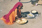 A girl from the Gadia Lohars nomadic tribe of Marwar, cooking her food.
 -
 Thar life
 -
 Desert tribes near Jaisalmer, India


Water and housing in the desert
In the true desert areas, the only sources of water for animals or humans are small, scattered ponds - some that are natural (tobas) and some that are human-made (
Crowded housing conditions are common in some areas.
-
 Huts in the Thar Desert
 -
 Johads are common water sources
 -
 Tanks for drinking water


Economy
Agriculture
The Thar is one of the most heavily populated desert areas in the world with the main occupations of its inhabitants being agriculture and animal husbandry.
Agricultural production is mainly from
The Thar region of Rajasthan is a major opium production and consumption area.[34][35]
-
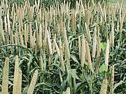 Bajra is the main kharif crop in Thar.
 -
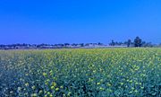 Mustard fields in a village of Shri Ganganagar district (Rajasthan, India).


Livestock
-
![Thari cow breed originating from Tharparkar, Sindh, popular since World War I[36]](//upload.wikimedia.org/wikipedia/commons/thumb/d/d5/Tharparkar_02.JPG/180px-Tharparkar_02.JPG) Tharparkar, Sindh, popular since World War I[36]
Tharparkar, Sindh, popular since World War I[36] -
 Cattle in the Thar Desert
![Thari cow breed originating from Tharparkar, Sindh, popular since World War I[36]](/File:Tharparkar_02.JPG)

Agroforestry

P. cineraria wood is reported to contain high calorific value and provide high-quality fuel wood. The lopped branches are good as fencing material. Its roots also encourage nitrogen fixation, which produces higher crop yields.

Ecotourism
Desert safaris on camels have become increasingly popular around Jaisalmer. Domestic and international tourists frequent the desert seeking adventure on camels for one to several days. This ecotourism industry ranges from cheaper backpacker treks to plush Arabian night-style campsites replete with banquets and cultural performances. During the treks, tourists are able to view the fragile and beautiful ecosystem of the Thar Desert. This form of tourism provides income to many operators and camel owners in Jaisalmer, as well as employment for many camel trekkers in the desert villages nearby. People from various parts of the world come to see the Pushkar ka Mela (Pushkar Fair) and oases.
-
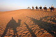 Camel ride in the Thar Desert near Jaisalmer, India
 -
 Sunrise in the desert


Industry
The government of India initiated departmental exploration for oil in 1955 and 1956 in the Jaisalmer area,[37] Oil India Limited discovered natural gas in 1988 in the Jaisalmer basin.[38]
History
The Desert National Park in Jaisalmer district has a collection of 180-million-year- old animal and plant fossils.
Because the kingdom's main source of income had long been levies on
In 1965 and 1971, population exchanges took place in the Thar between India and Pakistan; 3,500 Muslims shifted from the Indian section of the Thar to Pakistani Thar, whilst thousands of Hindu families also migrated from Pakistani Thar to the Indian section.[45][46][47]
Thar in ancient literature


1 = ancient river
2 = today's river
3 = today's Thar desert
4 = ancient shore
5 = today's shore
6 = today's town
7 = paelochannels (Clift et al. (2012))
See also

- Arid Forest Research Institute
- Arid Lands Information Network
- Aridification
- Cholistan Desert
- Nara desert
- Cyclone Phet – tracked directly over the desert
- Deforestation
- Geography of India
- History of Thar
- List of deserts by area
- Marwar
- Pokhran
- Thari people
Notes
- ^ See Clift et al. (2012) map and Honde te al. (2017) map.
- ^ In contrast to the mainstream view, Chatterjee et al. (2019) suggest that the river remained perennial till 4,500 years ago.
- ^ Giosan et al. (2012):
- "Contrary to earlier assumptions that a large glacier-fed Himalayan river, identified by some with the mythical Sarasvati, watered the Harappan heartland on the interfluve between the Indus and Ganges basins, we show that only monsoonal-fed rivers were active there during the Holocene."
- "Numerous speculations have advanced the idea that the Ghaggar-Hakra fluvial system, at times identified with the lost mythical river of Sarasvati (e.g., 4, 5, 7, 19), was a large glacier fed Himalayan river. Potential sources for this river include the Yamuna River, the Sutlej River, or both rivers. However, the lack of large-scale incision on the interfluve demonstrates that large, glacier-fed rivers did not flow across the Ghaggar-Hakra region during the Holocene
- "The present Ghaggar-Hakra valley and its tributary rivers are currently dry or have seasonal flows. Yet rivers were undoubtedly active in this region during the Urban Harappan Phase. We recovered sandy fluvial deposits approximately 5;400 y old at Fort Abbas in Pakistan (SI Text), and recent work (33) on the upper Ghaggar-Hakra interfluve in India also documented Holocene channel sands that are approximately 4;300 y old. On the upper interfluve, fine-grained floodplain deposition continued until the end of the Late Harappan Phase, as recent as 2,900 y ago (33) (Fig. 2B). This widespread fluvial redistribution of sediment suggests that reliable monsoon rains were able to sustain perennial rivers earlier during the Holocene and explains why Harappan settlements flourished along the entire Ghaggar-Hakra system without access to a glacier-fed river."
References
- ^ a b "Thar Desert". Terrestrial Ecoregions. World Wildlife Fund.
- PMID 28608869.
- ^ a b c Sinha, R. K.; Bhatia, S. & Vishnoi, R. (1996). "Desertification control and rangeland management in the Thar desert of India". RALA Report No. 200: 115–123.
- ISBN 978-3-540-87408-9.
- ^ "The Oldest Plant-Eating Dinosaur Has Been Found in India". The New York Times. 19 August 2023. Retrieved 23 August 2023.
- .
- ^ Kuhle, M (2004). "The High Glacial (Last Ice Age and LGM) ice cover in High and Central Asia". In Ehlers, J.; Gibbard, P.L. (eds.). Development in Quaternary Science 2c (Quaternary Glaciation – Extent and Chronology, Part III: South America, Asia, Africa, Australia, Antarctica). pp. 175–99.
- S2CID 128089823. See chapter entitled: "Reconstruction of an approximately complete Quaternary Tibetan Inland Glaciation between the Mt. Everest and Cho Oyu Massifs and the Aksai Chin. – A new glaciogeomorphological southeast-northwest diagonal profile through Tibet and its consequences for the glacial isostasy and Ice Age cycle".
- S2CID 129234912. Tibet and High-Asia I. Results of the Sino-German Joint Expeditions (I).
- ^ Kuhle, Matthias (2001). "The Tibetan Ice Sheet; its Impact on the Palaeomonsoon and Relation to the Earth's Orbital Variations". Polarforschung. 71 (1/2): 1–13.
- ^ a b c Giosan et al. 2012.
- ^ a b Maemoku et al. 2013.
- ^ a b c Clift et al. 2012.
- ^ a b c Singh et al. 2017.
- ^ Sankaran 1999.
- ISBN 9781444300741.
- .
- ISBN 978-1119055471. Retrieved 6 May 2016.
- ^ Sharma, K. K., S. Kulshreshtha, A. R. Rahmani (2013). Faunal Heritage of Rajasthan, India: General Background and Ecology of Vertebrates. Springer Science & Business Media, New York.
- S2CID 83995201.
- ^ a b c Singh, P. (ed.) (2007). "Report of the Task Force on Grasslands and Deserts" Archived 10 December 2011 at the Wayback Machine. Government of India Planning Commission, New Delhi.
- ^ WII (2015). Conservation Reserves Archived 10 April 2015 at the Wayback Machine Wildlife Institute of India, Dehradun.
- ISSN 0030-9923.
- ^ a b "Protected Areas". Archived from the original on 3 February 2020. Retrieved 21 April 2020.
- ISSN 1810-2719. Archived from the originalon 12 April 2023. Retrieved 21 August 2022.
- ^ "Lal Suhanra". UNESCO. Retrieved 28 December 2016.
- ^ "UNESCO - MAB Biosphere Reserves Directory". www.unesco.org. Retrieved 21 April 2020.
- OCLC 549213.
- ISBN 9788173870439.
- )
- S2CID 82472637.
- ^ Raza, Hassan (5 March 2012). "Mithi: Where a Hindu fasts and a Muslim does not slaughter cows". Dawn.
- ISBN 81-86103-05-8
- ^ "ICMR Bulletin vol.38, No.1-3, Pattern and Process of Drug and Alcohol Use in India" (PDF). Archived from the original (PDF) on 28 March 2022. Retrieved 10 May 2022.
- ^ "Will Rajasthan opium farmers vote for change?". Archived from the original on 10 May 2022. Retrieved 10 May 2022.
- ^ "Breeds of Livestock - Tharparkar Cattle — Breeds of Livestock, Department of Animal Science". afs.okstate.edu. Retrieved 5 August 2019.
- ^ "PlanningCommission.NIC.in". Archived from the original on 14 April 2006. Retrieved 16 November 2009.
- ^ OilIndia.NIC.in Archived 30 June 2006 at the Wayback Machine
- ^ "Rajasthan or the Central and Western Rajpoot States, Volume 2, page 197-198". Higginbotham And Co. Madras. 14 August 2018.
- ^ "Imperial Gazetter of India, Volume 21, page 272 - Imperial Gazetteer of India - Digital South Asia Library". Dsal.uchicago.edu. 18 February 2013. Retrieved 22 November 2013.
- ^ "Bhatinda Government: District at A glance- Origin". Bhatinda Government. 14 August 2018. Archived from the original on 10 January 2011. Retrieved 14 August 2018.
- ^ "Provincial Gazetteers Of India: Rajputana". Government of India. 14 August 2018.
- ^ "Princely States of India".
- ^ "Provincial Gazetteers Of India: Rajputana". Government of India. 14 August 2018.
- ISBN 9781843697343.
- ^ Maini, Tridivesh Singh (15 August 2012). "Not just another border". Himal South Asian.
- ^ Arisar, Allah Bux (6 October 2015). "Families separated by Pak-India border yearn to see their loved ones". News Lens Pakistan. Archived from the original on 25 December 2016. Retrieved 25 December 2016.
- ^ See map
Web
- ^ Mythical Saraswati River, Press Information Bureau, Government of India, 20 March 2013.Archived 9 October 2016 at the Wayback Machine
Sources
- Chatterjee, Anirban; Ray, Jyotiranjan S.; Shukla, Anil D.; Pande, Kanchan (20 November 2019). "On the existence of a perennial river in the Harappan heartland". Scientific Reports. 9 (1): 17221. PMID 31748611.
- Clift, Peter D.; Carter, Andrew; Giosan, Liviu; Durcan, Julie; et al. (2012), "U-Pb zircon dating evidence for a Pleistocene Sarasvati River and capture of the Yamuna River", Geology, 40 (3): 211–214, S2CID 130765891
- Giosan; et al. (2012). "Fluvial landscapes of the Harappan civilization". PNAS. 109 (26): E1688–E1694. PMID 22645375.
- Giosan, Liviu; Clift, Peter D.; Macklin, Mark G.; Fuller, Dorian Q. (10 October 2013). "Sarasvati II". Current Science. 105 (7): 888–890. JSTOR 24098502.
- Khonde, Nitesh; Kumar Singh, Sunil; Maur, D. M.; Rai, Vinai K.; Chamyal, L. S.; Giosan, Liviu (2017), "Tracing the Vedic Saraswati River in the Great Rann of Kachchh", Scientific Reports, 7 (1): 5476, PMID 28710495
- Maemoku, Hideaki; Shitaoka, Yorinao; Nagatomo, Tsuneto; Yagi, Hiroshi (2013). "Geomorphological Constraints on the Ghaggar River Regime During the Mature Harappan Period". In Giosan, Liviu; Fuller, Dorian Q.; Nicoll, Kathleen; Flad, Rowan K.; Clift, Peter D. (eds.). Climates, Landscapes, and Civilizations. American Geophysical Union Monograph Series 198. John Wiley & Sons. ISBN 978-1-118-70443-1.
- Sankaran, A. V. (25 October 1999). "Saraswati – The ancient river lost in the desert". Current Science. 77 (8): 1054–1060. JSTOR 24103577. Archived from the originalon 19 September 2004.
- Singh, Ajit; et al. (2017). "Counter-intuitive influence of Himalayan river morphodynamics on Indus Civilisation urban settlements". Nature Communications. 8 (1): 1617. PMID 29184098.
- Valdiya, K.S. (2013). "The River Saraswati was a Himalayan-born river" (PDF). Current Science. 104 (1): 42.
Further reading
- Bhandari M. M. Flora of The Indian Desert, MPS Repros, 39, BGKT Extension, New Pali Road, Jodhpur, India.
- Zaigham, N. A. (2003). "Strategic sustainable development of groundwater in Thar Desert of Pakistan". Water Resources in the South: Present Scenario and Future Prospects, Commission on Science and Technology for Sustainable Development in the South, Islamabad.
- Govt. of India. Ministry of Food & Agriculture booklet (1965)—"Soil conservation in the Rajasthan Desert"—Work of the Desert Afforestation Research station, Jodhpur.
- Gupta, R. K. & Prakash Ishwar (1975). Environmental analysis of the Thar Desert. English Book Depot., Dehra Dun.
- Kaul, R. N. (1967). "Trees or grass lands in the Rajasthan: Old problems and New approaches". Indian Forester, 93: 434–435.
- Burdak, L. R. (1982). "Recent Advances in Desert Afforestation". Dissertation submitted to Shri R. N. Kaul, Director, Forestry Research, F.R.I., Dehra Dun.
- Yashpal, Sahai Baldev, Sood, R.K., and Agarwal, D.P. (1980). "Remote sensing of the 'lost' Saraswati river". Proceedings of the Indian Academy of Sciences (Earth and Planet Science), V. 89, No. 3, pp. 317–331.
- Bakliwal, P. C. and Sharma, S. B. (1980). "On the migration of the river Yamuna". Journal of the Geological Society of India, Vol. 21, Sept. 1980, pp. 461–463.
- Bakliwal, P. C. and Grover, A. K. (1988). "Signature and migration of Sarasvati river in Thar desert, Western India". Record of the Geological Survey of India V 116, Pts. 3–8, pp. 77–86.
- Rajawat, A. S., Sastry, C. V. S. and Narain, A. (1999-a). "Application of pyramidal processing on high resolution IRS-1C data for tracing the migration of the Saraswati river in parts of the Thar desert". in "Vedic Sarasvati, Evolutionary History of a Lost River of Northwestern India", Memoir Geological Society of India, Bangalore, No. 42, pp. 259–272.
- Ramasamy, S. M. (1999). "Neotectonic controls on the migration of Sarasvati river of the Great Indian desert". in "Vedic Sarasvati, Evolutionary History of a Lost River of Northwestern India", Memoir Geological Society of India, Bangalore, No. 42, pp. 153–162.
- Rajesh Kumar, M., Rajawat, A. S. and Singh, T. N. (2005). "Applications of remote sensing for educidate the Palaeochannels in an extended Thar desert, Western Rajasthan", 8th annual International conference, Map India 2005, New Delhi.
External links
 Thar Desert travel guide from Wikivoyage
- Rajasthan Tourism
- "Thar Desert". Terrestrial Ecoregions. World Wildlife Fund.
- Dharssi.org.uk, Photos of the Thar Desert
- Avgustin.net, Photos of the Thar Desert in Pakistan side
- MIT.gov[permanent dead link], आपणो राजस्थान
| History |
|
|---|---|
| Government and politics | |
| Culture |
|
Geography |
|
| Education |
|
| Sports | |
| Flora & Fauna | |
| Sindhi Media | |
| Sindhi Websites | |
| Sindh Tourism | |