
The Narrows
40°36′48″N 74°02′53″W / 40.61333°N 74.04806°W
| The Narrows | |
|---|---|
Upper New York Bay | |
| Mouth | Lower New York Bay |
The Narrows is the
History
Pre-history
The Narrows was most likely formed after deposition of the Harbor Hill Moraine about 18,000 years prior to the end of the last ice age. Previously, Staten Island and Brooklyn were connected and the Hudson River emptied into the Atlantic Ocean through the Raritan River, taking a more westerly course through parts of present-day northern New Jersey, along the eastern side of the Watchung Mountains to Bound Brook, New Jersey, and then on into the Atlantic via Raritan Bay. A build-up of water in the Upper Bay allowed the river to break through to form The Narrows less than 12,000 to 13,000 years ago as it exists today.[1]
Post-European contact
The first recorded European entrance into The Narrows was in 1524 by Giovanni da Verrazzano, who set anchor in the strait and was greeted by a group of Lenape, who paddled out to meet him in the strait.
In August 1776, the British forces under William Howe on Staten Island undertook an amphibious operation across the Narrows and landed in Brooklyn, where they routed Washington's Army at the Battle of Long Island.
The
-

-
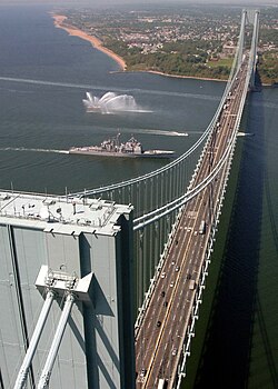 The Verrazzano-Narrows Bridge, shown with USS Leyte Gulf passing underneath it, spans The Narrows
 -
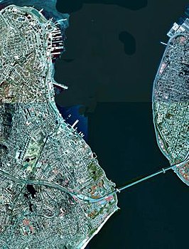 A satellite view of The Narrows with Staten Island (on the left) and Brooklyn (on the right) connected by the Verrazzano-Narrows Bridge
.jpg)
_under_the_Verrazano_Narrows_Bridge.jpg)

See also
- Geography of New York–New Jersey Harbor Estuary
- List of longest suspension bridge spans
- Staten Island Tunnel
References
Notes
- ^ Charles Merguerian (2003): The Narrows, Flood – Post-Woodfordian Meltwater Breach of the Narrows Channel, NYC (pdf; 1,5 MB)
- ISBN 978-0-82325-369-2.
- ISSN 0362-4331. Retrieved November 28, 2022.
- ^ McCauley, J. K. (November 25, 2014). "The Verrazano-Narrows Bridge at 50". City Room. Retrieved November 28, 2022.
Bibliography
- Merguerian, Charles. "The Narrows, Flood – Post-Woodfordian Meltwater Breach of the Narrows Channel, NYC" (2003)
- Waldman, John. Heartbeats in the Muck The Lyons Press; (2000). ISBN 1-55821-720-7
External links
 Media related to The Narrows at Wikimedia Commons
| International | |
|---|---|
| National | |