
Thimphu District
Thimphu Dzongkhag
ཐིམ་ཕུ་རྫོང་ཁག | |
|---|---|
UTC+6 (BTT) | |
| HDI (2021) | 0.832[1] very high · 1st |
| Website | www |
27°35′N 89°35′E / 27.583°N 89.583°E
Thimphu District (
is also the capital of Bhutan and the largest city in the whole kingdom.Languages
The dominant language throughout the district is Dzongkha; however, within the capital nearly every language of Bhutan may be encountered.[2]
Administrative divisions
Thimphu District is divided into eight

- Chang Gewog
- Dagala Gewog
- Genyekha Gewog
- Kawang Gewog
- Lingzhi Gewog
- Mewang Gewog
- Naro Gewog
- Soe Gewog
Lingzhi, Soe and Naro Gewogs belong to the Lingzhi Dungkhag subdistrict, the only subdistrict within Thimphu District. The remaining gewogs do not belong to any subdistrict.[4]
Town of Thimphu
Thimphu is the capital of Bhutan and Thimphu district.
Environment
The northern half of Thimphu District (the gewogs of Kawang, Lingzhi, Naro and Soe – corresponding roughly to Lingzhi Dungkhag) is subject to environmental protection, falling within Jigme Dorji National Park.[5]
- Thimphu District
-
 View of Thimphu
 -
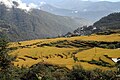 Rice terraces
 -
 Traditional house
 -
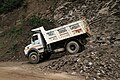 Expansion of the road to Dochu La
 -
 108 Choerten on the Dochu La
 -
 View from Dochu La


See also
References
- ^ "Sub-national HDI - Area Database - Global Data Lab". hdi.globaldatalab.org. Retrieved 2018-09-13.
- SOAS. Retrieved 2011-01-18.
- Government of Bhutan. 2011. Retrieved 2011-07-28.
- ^ "Lingzhi Geog". Thimphu Dzongkhag Administration. Archived from the original on September 6, 2009.
- ^ "Parks of Bhutan". Bhutan Trust Fund for Environmental Conservation online. Bhutan Trust Fund. Archived from the original on 2011-07-02. Retrieved 2011-03-26.
External links
| Authority control databases: Geographic |
|---|
This Bhutan location article is a stub. You can help Wikipedia by expanding it. |