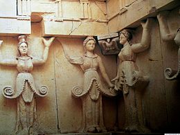
Thracian Tomb of Sveshtari
| UNESCO World Heritage Site | |
|---|---|
 | |
| Location | Razgrad Province, Bulgaria |
| Criteria | Cultural: (i), (iii) |
| Reference | 359 |
| Inscription | 1985 (9th Session) |
| Area | 647.6 ha (1,600 acres) |
| Coordinates | 43°44′42″N 26°45′59″E / 43.744964°N 26.7663°E |
The Thracian Tomb of Svestari (Свещарска гробница, Sveshtarska grobnitsa) is 2.5 kilometers (1.6 mi) southwest of the village of Sveshtari,
romanized: Dromichaites; c. 300 – c. 280 BCE) who was a king of the Getae on both sides of the lower Danube (present day Romania and Bulgaria) around 300 BCE, and his wife, the daughter of King Lysimachus (Greek: Λυσίμαχος, Lysimachos; c. 360 – 281 BCE) who was a general and diadochus (i.e., "successor") of Alexander the Great.[1][2] The tomb is a UNESCO World Heritage Site.[3]
General information
Discovered and excavated in 1982 during excavations at Mound No 7 of the East Mound Necropolis of Sboryanovo (Ginina Mogila) – a
Hyperborean worlds, according to ancient geographers.[3]
In 2012, archaeologists uncovered a significant treasure near the village. The treasure included a golden ring, 44 female figure depictions and 100 golden buttons, found in 150 tombs from the 4th century BC. It has been suggested that it is part of the site of the Getan city of Helis.[1]
-
The Entrance to the Tomb Mound
-
The interior of the tomb
-
The Thracian Tomb of Sveshtari
History
The Getae had been federated in the
Getic tribes.[10]
The Getic tomb at
Sveshtari in the western Ludogorie in Bulgaria is also supposed to have been near the location of Helis.[11] In the vicinity of the mausoleum, the remains of a large ancient city were found along with dozens of Getic mound tombs. The settlement is situated in a natural stronghold, a plateau surrounded like a peninsula by the ravines of Krapinets River.[12][13] The outer stone wall, up to 4m thick, follows the edges of the peninsula and defends a territory of about 10 hectares. The inner wall, of similar construction, encloses a roughly quadrilateral area of about 5 hectares.[13] The fortified territory was relatively densely occupied by dwellings connected by a network of thoroughfares.[14] Dating finds such as amphorae stamps and coins indicate that this settlement existed between c. 335 and c. 250 BC.[13][15]
See also
- Thracian tomb of Aleksandrovo
- Thracian tomb of Cotys I (Mogilan mound)
- Thracian tomb Golyama Arsenalka
- Thracian tomb Griffins
- Thracian tomb Helvetia
- Thracian Tomb of Kazanlak
- Thracian tomb Ostrusha
- Thracian tomb of Seuthes III
- Thracian tomb Shushmanets
- Valley of the Thracian Rulers
- Roman Tomb (Silistra)
References
- ^ JSTOR 1558897.
- OCLC 936205702.
- ^ a b "Thracian Tomb of Sveshtari". UNESCO World Heritage Centre. Retrieved 21 January 2020.
- ^ "Sveshtarska Tomb". Ministry of Tourism. Retrieved 21 January 2020.
- ^ Archibald 1994, p. 472.
- ^ Archibald 1994, pp. 467–472.
- ^ a b Lund 1992, p. 43.
- ^ Sîrbu 2006, p. 42.
- ^ Archibald 1994, p. 473.
- ^ Delev 2000, pp. 396, 399.
- ^ Delev 2000, p. 400.
- ^ Emilov 2007, p. 63.
- ^ a b c Delev 2000, p. 398.
- ^ Stoyanov & Mihaylova 1996, p. 55.
- ^ Stoyanov & Mihaylova 1996, pp. 55, 57.
Bibliography
- Archibald, Zofia H. (1994). "Thracians and Scythians". The Cambridge Ancient History. Vol. 6 (2 ed.).
- Delev, P. (2000). "Lysimachus, the Getae, and Archaeology". The Classical Quarterly. 50 (2). Cambridge University: 384–401. JSTOR 1558897.
- Emilov, Julij (2007). "La Tène finds and the indigenous communities in Thrace. Interrelations during the Hellenistic period". Studia Hercynia. 11: 57–75.
- Alexander Fol, M. Čičikova, T. Ivanov, T. Teofilov: The Thracian Tomb near the Village of Sveshtari, Sofia 1986.
- Alexander Fol: "Die thrakische Orphik oder Zwei Wege zur Unsterblichkeit", in Die Thraker. Das goldene Reich des Orpheus, Ausstellung 23. Juli bis 28. November 2004, Kunst- und Ausstellungshalle der Bundesrepublik Deutschland. Philipp von Zabern, Mainz 2004, pp. 177–186.
- Lund, Helene S. (1992). Lysimachus. A Study in Early Hellenistic Kingship. Taylor & Francis Ltd. ISBN 978-0415070614.
- Sîrbu, Valeriu (2006). "Elitele geţilor dintre Carpaţi şi Balcani (sec. IV-II a. Chr): 'prinţii de aur şi argint'". Istros. XIII: 41–70.
- Stoyanov, T.; Mihaylova, Zh. (1996). "Metalworking in the Getic City in Sboryanovo locality near Isperih, NE Bulgaria (Preliminary report)". Ephemeris Napocensis. 6: 55–77.
Further reading
- Chichikova, Maria (2012). "Caryatids of the Royal Tomb at Sveshtari". ORPHEUS. Journal of Indo-European and Thracian Studies. 19: 5–22.
External links
Wikimedia Commons has media related to Thracian Tomb of Sveshtari.


