
Thuringia
Free State of Thuringia
| ||
|---|---|---|
|
NUTS Region DEG | | |
| HDI (2018) | 0.928[3] very high · 12th of 16 | |
| Website | thueringen.de | |

Thuringia,[a] officially the Free State of Thuringia,[b] is a state of central Germany, covering 16,171 square kilometres (6,244 sq mi), the sixth smallest of the sixteen German states. It has a population of about 2.1 million.[4]
Erfurt is the capital and largest city. Other cities are Jena, Gera and Weimar. Thuringia is bordered by Bavaria, Hesse, Lower Saxony, Saxony-Anhalt, and Saxony. It has been known as "the green heart of Germany" (das grüne Herz Deutschlands) from the late 19th century due to its broad, dense forest.[5] Most of Thuringia is in the Saale drainage basin, a left-bank tributary of the Elbe.
Thuringia is home to the
Thuringia had an earlier existence as the
Etymology and symbols

The name Thuringia or Thüringen derives from the Germanic tribe
The Thuringian Realm existed until after 531, the Landgraviate of Thuringia was the largest state in the region, persisting between 1131 and 1247. Afterwards the state known as Thuringia ceased to exist; nevertheless the term commonly described the region between the Harz mountains in the north, the White Elster river in the east, the Franconian Forest in the south and the Werra river in the west. After the Treaty of Leipzig, Thuringia had its own dynasty again, the Ernestine Wettins. Their various lands formed the Free State of Thuringia, founded in 1920, together with some other small principalities. The Prussian territories around Erfurt, Mühlhausen and Nordhausen joined Thuringia in 1945.
The coat of arms of Thuringia shows the lion of the Ludowingian Landgraves of 12th-century origin. The eight stars around it represent the eight former states which formed Thuringia. The flag of Thuringia is a white-red bicolor, derived from the white and red stripes of the Ludowingian lion. The coat of arms and flag of Hesse are quite similar to the Thuringian ones, since they are also derived from the Ludowingian symbols.
Symbols of Thuringia in popular culture are the Bratwurst and the Forest, because a large amount of the territory is forested.
History
Named after the Thuringii Germanic tribe who occupied it around AD 300, Thuringia came under Frankish domination in the 6th century.
Thuringia became a
Thuringia generally accepted the
Early modern period
The modern German black-red-gold tricolour flag's first appearance anywhere in a German-ethnicity sovereign state, within what today comprises Germany, occurred in 1778 as the state flag of the Principality of Reuss-Greiz, a defunct principality in the modern state's borders.

Some reordering of the Thuringian states occurred during the
Free State of Thuringia
In 1920, after World War I, these small states merged into one state, called the Free State of Thuringia (Freistaat Thüringen); only Saxe-Coburg voted to join Bavaria instead. Weimar became the new capital. The coat of arms of this new state was simpler than those of its predecessors. The Landtag of the newly established state first convened in 1920 in Weimar. Its deputies were elected for three years according to proportional representation, with a minimum voting age of 21. Between 1920 and 1932, under the Weimar Republic, six Landtag elections were held.
Thuringia was one of the states where the
After being controlled briefly by the US following the end of the
In 1952, the
The present State of Thuringia was recreated with slightly altered borders during German reunification in 1990.
Geography
Topography
From the northwest going clockwise; Thuringia borders on the German states of Lower Saxony, Saxony-Anhalt, Saxony, Bavaria and Hesse.

The landscapes of Thuringia are quite diverse. The far north is occupied by the
There are two large rivers in Thuringia. The Saale, a tributary of the Elbe, with its tributaries the Unstrut, Ilm and White Elster, drains the most part of Thuringia. The Werra – the headwater of the Weser – drains the south-west and west of the state. Furthermore, some small areas on the southern border are drained by tributaries of the Main, itself a tributary of the Rhine. There are no large natural lakes in Thuringia, but it does have some of Germany's biggest dams, including the Bleiloch Dam and the Hohenwarte Dam on the River Saale, as well as the Leibis-Lichte Dam and the Goldisthal Pumped Storage Station in the Thuringian Highlands. Thuringia is Germany's only state with no connection to navigable waterways.
The geographic centre of the Federal Republic is in Thuringia, within the municipality of Vogtei next to Mühlhausen. The centre of Thuringia is eight kilometres south of the capital's Cathedral, in the municipality of Rockhausen.
Climate
Thuringia's climate is temperate with humid westerly winds predominating. Increasingly as one moves from the north-west to the south-east, the climate shows continental features: winters can be cold for long periods, and summers can become warm. Dry periods are often recorded, especially within the Thuringian Basin, leeward to mountains in all directions. It is Germany's driest area, with annual precipitation of only 400 to 500 mm.
Artern, in the north-east, is warm and dry, with a mean annual temperature of 8.5 °C and mean precipitation of 450 mm; contrast this with wet, cool Oberhof, in the Thuringian Forest, where temperature averages only 4.4 °C and mean annual precipitation reaches 1300 mm.
| Climate data for Erfurt (1971–2000) | |||||||||||||
|---|---|---|---|---|---|---|---|---|---|---|---|---|---|
| Month | Jan | Feb | Mar | Apr | May | Jun | Jul | Aug | Sep | Oct | Nov | Dec | Year |
| Mean daily maximum °C (°F) | 2.2 (36.0) |
3.2 (37.8) |
7.8 (46.0) |
12.2 (54.0) |
17.5 (63.5) |
20.1 (68.2) |
22.5 (72.5) |
22.7 (72.9) |
18.3 (64.9) |
12.7 (54.9) |
6.4 (43.5) |
3.4 (38.1) |
12.4 (54.3) |
| Mean daily minimum °C (°F) | −3.1 (26.4) |
−2.9 (26.8) |
0.3 (32.5) |
2.8 (37.0) |
7.1 (44.8) |
10.2 (50.4) |
12.1 (53.8) |
12.0 (53.6) |
9.1 (48.4) |
5.1 (41.2) |
0.9 (33.6) |
−1.5 (29.3) |
4.3 (39.7) |
| Average precipitation mm (inches) | 24.7 (0.97) |
23.8 (0.94) |
35.5 (1.40) |
40.3 (1.59) |
54.8 (2.16) |
60.8 (2.39) |
62.5 (2.46) |
52.8 (2.08) |
40.5 (1.59) |
36.8 (1.45) |
37.5 (1.48) |
31.5 (1.24) |
501.5 (19.74) |
| Average precipitation days (≥ 1.0 mm) | 7.0 | 6.7 | 8.3 | 7.9 | 8.5 | 10.0 | 8.7 | 8.3 | 7.4 | 6.9 | 7.8 | 7.6 | 95.1 |
| Source: World Meteorological Organization[7] | |||||||||||||
Nature and environment


Due to many centuries of intensive settlement, most of the area is shaped by human influence. The original natural vegetation of Thuringia is forest with
Environmental damage in Thuringia has been reduced to a large extent after 1990. The condition of forests, rivers and air was improved by modernizing factories, houses (decline of coal heating) and cars, and contaminated areas such as the former Uranium surface mines around Ronneburg have been remediated. Today's environmental problems are the salination of the Werra river, caused by discharges of K+S salt mines around Unterbreizbach and overfertilisation in agriculture, damaging the soil and small rivers.
Environment and nature protection has been of growing importance and attention since 1990. Large areas, especially within the forested mountains, are protected as natural reserves, including Thuringia's first national park within the Hainich mountains, founded in 1997, the Rhön Biosphere Reserve, the Thuringian Forest Nature Park and the South Harz Nature Park.
Demographics
Demographic history
During the Middle Ages, Thuringia was at the border between
|
| ||||||||||||||||||||||||||||||||||||||||||||||||||||||||||||||||||||||||||||||||||||||||||||||||||||||||||||||||||||||||
| Source: Thüringer Landesamt für Statistik[1] | |||||||||||||||||||||||||||||||||||||||||||||||||||||||||||||||||||||||||||||||||||||||||||||||||||||||||||||||||||||||||
The 1981 census projected that Thuringia's population would reach 2,221,222 by 2011. The population counted in the 2011 census was 2,181,603, which is about 1.78% less.
| Nationality | Population (31 December 2022) |
|---|---|
| 32,150 | |
| 16,435 | |
| 14,255 | |
| 13,475 | |
| 7,385 | |
| 6,250 | |
| 5,320 | |
| 4,340 | |
| 4,130 | |
| 3,835 |
Current population
The current population is 2,120,237 (31 December 2020) with an annual rate of decrease of about 0.5%, which varies widely between the local regions. In 2012, 905,000 Thuringians lived in a municipality with more than 20,000 inhabitants, this is an urbanization rate of 42% which continues to rise.
In July 2013, there were 41,000 non-Germans by citizenship living in Thuringia (1.9% of the population − among the smallest proportions of any state in Germany). Nevertheless, the number rose from 33,000 in July 2011, an increase of 24% in only two years. About 4% of the population are migrants (including persons that already received German citizenship). The biggest groups of foreigners by citizenship are (as of 2012): Russians (3,100), Poles (3,000), Turks (2,100) and Ukrainians (2,000). The number of foreigners varies between regions: the college towns Erfurt, Jena, Weimar and Ilmenau have the highest rates, whereas there are almost no migrants living in the most rural smaller municipalities.
The Thuringian population has a significant sex ratio gap, caused by the emigration of young women, especially in rural areas. Overall, there are 115 to 120 men per 100 women in the 25–40 age group ("family founders") which has negative consequences for the birth ratio. Furthermore, the population is getting older and older with some rural municipalities recording more than 30% of over-65s (pensioners). This is a problem for the regional labour market, as there are twice as many people leaving as entering the job market annually.
Natural and spatial tendencies
The birth rate was about 1.8 children per women in the 1970s and 1980s, shrinking to 0.8 in 1994 during the economic crisis after the reunification and rose again to more than 1.4 children in 2010, which is a higher level than in West Germany. Nevertheless, there are only 17,000 births compared to 27,000 deaths per year, so that the annual natural change of the Thuringian population is about −0.45%. In 2015 there were 17,934 births, the highest number since 1990.
Migration plays an important role in Thuringia. The internal migration shows a strong tendency from rural areas towards the big cities. From 2008 to 2012, there was a net migration from Thuringia to Erfurt of +6,700 persons (33 per 1000 inhabitants), +1,800 to Gera (19 per 1000), +1,400 to Jena (14 per 1000), +1,400 to Eisenach (33 per 1000) and +1,300 to Weimar (21 per 1000). Between Thuringia and the other German states, the balance is negative: In 2012, Thuringia lost 6,500 persons to other federal states, the most to Bavaria, Saxony, Hesse and Berlin. Only with Saxony-Anhalt and Brandenburg the balance is positive. The international migration is fluctuating heavily. In 2009, the balance was +700, in 2010 +1,800, in 2011 +2,700 and in 2012 +4,800. The most important countries of origin of the Thuringia migrants from 2008 to 2012 were Poland (+1,700), Romania (+1,200), Afghanistan (+1,100) and Serbia/Montenegro/Kosovo (+1,000), whereas the balance was negative with Switzerland (−2,800) and Austria (−900).
Vital statistics
- Births January–November 2016 =
 17,008
 - Births January–November 2017 =
 −16,641
 - Deaths January–November 2016 =
 −25,644
 - Deaths January–November 2017 =
 26,854
 - Natural growth January–November 2016 = 8,636
- Natural growth January–November 2017 = −10,213
Cities, towns and villages
Of the approximately 850 municipalities of Thuringia, 126 are classed as towns (within a district) or cities (forming their own urban district). Most of the towns are small with a population of less than 10,000; only the ten biggest ones have a population greater than 30,000. The first towns emerged during the 12th century, whereas the latest ones received town status only in the 20th century. Today, all municipalities within districts are equal in law, whether they are towns or villages. Independent cities (i.e. urban districts) have greater powers (the same as any district) than towns within a district.
| Rank | City | District | Pop. 31 December 2020[1] | Change* | CoA | Image |
|---|---|---|---|---|---|---|
| 1 | Erfurt | independent | 213,692 | +0.68 | 
|

|
| 2 | Jena | independent | 110,731 | +0.47 | 
|

|
| 3 | Gera | independent | 92,126 | −0.55 | 
|

|
| 4 | Weimar | independent | 65,098 | +0.35 | 
|

|
| 5 | Gotha | Gotha | 45,273 | −0.05 | 
|

|
| 6 | Nordhausen | Nordhausen | 40,969 | −0.35 | 
|

|
| 7 | Eisenach | Wartburgkreis | 41,970 | −0.12 | 
|

|
| 8 | Suhl | independent | 36,395 | −1.68 | 
|

|
| 9 | Mühlhausen | Unstrut-Hainich-Kreis | 35,799 | −0.38 | 
|

|
| 10 | Altenburg | Altenburger Land | 31,101 | −1.27 | 
|

|
* Average annual change in percent within the last three years (13 December 2009 to 31 December 2012), adjusted from incorporations and the 2011 Census results.
Religion
Since the
The Protestant parishes of Thuringia belong to the
in the very west).-
 EKD Protestant membership in 2011 (municipalities)
 -
 Catholic membership in 2011 (municipalities)


Politics
National
Thuringia is a stronghold for the Alternative for Germany (AfD), the party emerged as the largest in Thuringia in the 2021 national elections.[10] In 2017 the party got 22.7%, while in 2021 they got 24.0%.
List of minister-presidents of Thuringia
October 2019 state election

| ||||||||
| Party | Votes | % | +/- | Seats | +/- | Seats % | ||
|---|---|---|---|---|---|---|---|---|
| The Left (Die Linke) | 343,780 | 31.0 | 29 | 32.2 | ||||
| Alternative for Germany (AfD) | 259,382 | 23.4 | 22 | 24.4 | ||||
| Christian Democratic Union (CDU) | 241,049 | 21.7 | 21 | 23.3 | ||||
| Social Democratic Party (SPD) | 90,987 | 8.2 | 8 | 8.9 | ||||
| Alliance 90/The Greens (Grünen) | 57,474 | 5.2 | 5 | 5.6 | ||||
| Free Democratic Party (FDP) | 55,493 | 5.0 | 5 | 5.6 | ||||
| National Democratic Party of Germany | 6,044 | 0.5 | 0 | ±0 | 0 | |||
| Others | 54,179 | 4.9 | 0 | ±0 | 0 | |||
| Valid votes | 1,108,388 | 98.8 | ||||||
| Blank and invalid votes | 13,426 | 1.2 | ||||||
| Total | 1,121,814 | 100.0 | 90 | |||||
| Electorate / voter turnout | 1,729,242 | 64.9 | ||||||
| Source: Thüringer Landesamt für Statistik | ||||||||
Local government
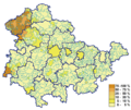
Thuringia is divided into 17 districts (Landkreise):

Furthermore, there are five urban districts:
Economy


Thuringia's economy is marked by the economic transition that happened after the German reunification and led to the closure of most of the factories within the Land. The unemployment rate reached a peak in 2005. Since that year, the economy has seen an upturn and the general economic situation has improved.
Agriculture and forestry
Agriculture and forestry have declined in importance over the decades. Nevertheless, they are more important than in most other areas of Germany, especially within rural regions. 54% of Thuringia's territory is in agricultural use. The fertile basins such as the large Thuringian Basin or the smaller Goldene Aue, Orlasenke and Osterland are in intensive use for growing cereals, vegetables, fruits and energy crops. Important products are apples, strawberries, cherries and plums in the fruit sector, cabbage, potatoes, cauliflower, tomatoes (grown in greenhouses), onions, cucumbers and asparagus in the vegetable sector, as well as maize, rapeseed, wheat, barley and sugar beets in the crop sector.
Meat production and processing is also an important activity, with swine, cattle, chickens and turkeys in focus. Furthermore, there are many milk and cheese producers, as well as laying hens. Trout and carp are traditionally bred in aquaculture in many villages.
Most agricultural enterprises are large cooperatives, founded as Landwirtschaftliche Produktionsgenossenschaft during the GDR period, and meat producers are part of multinational companies. Traditional private peasant agriculture is an exception, as is organic farming.
Thuringia's only wine-growing district is around Bad Sulza north of Weimar and Jena along the Ilm and Saale valley. Its production is marketed as Saale-Unstrut wines.
Forestry plays an important role in Thuringia because 32% of the Thuringian territory is forested. The most common trees are spruce, pine and beech. There are many wood and pulp-paper factories near the forested areas.
Industry and mining
Like most other regions of central and southern Germany, Thuringia has a significant industrial sector reaching back to the mid-19th-century industrialisation. The economic transition after the German reunification in 1990 led to the closure of most large-scale factories and companies, leaving small and medium-sized ones to dominate the manufacturing sector. Well-known industrial centres are
Mining was important in Thuringia since the later Middle Ages, especially within the mining towns of the
General economic parameters
The GDP of Thuringia is below the national average, in line with the other former East German Lands. Until 2004, Thuringia was one of the weakest regions within the European Union. The accession of several new countries, the crisis in southern Europe and the sustained economic growth in Germany since 2005 has brought the Thuringian GDP close to the EU average since then. The high economic subsidies granted by the federal government and the EU after 1990 are being reduced gradually and will end around 2020.
The unemployment rate reached its peak of 17.1% in 2005. Since then, it has decreased to 5.3% in 2019, which is only slightly above the national average. The decrease is caused on the one hand by the emergence of new jobs and on the other by a marked decrease in the working-age population, caused by emigration and low birth rates for decades. The wages in Thuringia are low compared to rich bordering Lands like Hesse and Bavaria. Therefore, many Thuringians are working in other German Lands and even in Austria and Switzerland as weekly commuters. Nevertheless, the demographic transition in Thuringia leads to a lack of workers in some sectors. External immigration into Thuringia has been encouraged by the government since about 2010 to counter this problem.
The economic progress is quite different between the regions of Thuringia. The big cities along the A4 motorway such as Erfurt, Jena and Eisenach and their surroundings are booming, whereas nearly all the rural regions, especially in the north and east, have little economic impetus and employment, which is a big issue in regional planning. Young people in these areas often have to commute long distances, and many emigrate soon after finishing school.
The unemployment rate stood at 5.9% in 2023 and was higher than the German average.[12][13]
| Year[14][12] | 2000 | 2001 | 2002 | 2003 | 2004 | 2005 | 2006 | 2007 | 2008 | 2009 | 2010 | 2011 | 2012 | 2013 | 2014 | 2015 | 2016 | 2017 | 2018 | 2019 | 2020 | 2021 | 2022 | 2023 |
|---|---|---|---|---|---|---|---|---|---|---|---|---|---|---|---|---|---|---|---|---|---|---|---|---|
| Unemployment rate in % | 15.4 | 15.3 | 15.9 | 16.7 | 16.7 | 17.1 | 15.6 | 13.1 | 11.2 | 11.4 | 9.8 | 8.8 | 8.5 | 8.2 | 7.8 | 7.4 | 6.7 | 6.1 | 5.5 | 5.3 | 6.0 | 5.6 | 5.3 | 5.9 |
Tourism
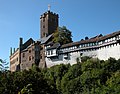
Tourism is an important branch of the economy. Thuringia has a number of well known destinations: Wartburg castle (UNESCO World Heritage Site), Classical Weimar (UNESCO World Heritage Site), Bauhaus Weimar (UNESCO World Heritage Site), Thuringian Forest, Oberhof or Rennsteig (ridge walk). City tourism with the centers of Erfurt, Weimar, Jena, Eisenach and Mühlhausen is experiencing dynamic growth. A total of around 9.2 million overnight stays were booked in 2016, compared to 8.3 million ten years earlier. Around 6% of the bookings were made by foreign guests.[15]
-
-
-

-

-
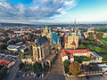 Erfurt skyline
 -
-
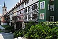
 Oldtown of Mühlhausen
 -


Infrastructure
Transport


As Germany's most central state, Thuringia is an important hub of transit traffic. The transportation infrastructure was in very poor condition after the
During the 1930s, the first two
The first railways in Thuringia had been built in the 1840s and the network of main lines was finished around 1880. By 1920, many branch lines had been built, giving Thuringia one of the densest rail networks in the world before World War II with about 2,500 km of track. Between 1950 and 2000 most of the branch lines were abandoned, reducing Thuringia's network by half compared to 1940. On the other hand, most of the main lines were refurbished after 1990, resulting in improved speed of travel. The most important railway lines at present are the
A few small airports are in Thuringia. In public transport is Erfurt–Weimar Airport, used for charter flights to the Mediterranean and other holiday destinations. In private flights, Leipzig–Altenburg Airport is a further key airport.
International hub airports are Frankfurt Airport, Berlin Brandenburg Airport and Munich Airport in adjacent states.
Thuringia is the only state without barge or ship waterways; its rivers are too small to be navigable to them.
Energy and water supply
The traditional energy supply of Thuringia is lignite, mined in the bordering Leipzig region. Since 2000, the importance of environmentally unfriendly lignite combustion has declined in favour of renewable energies, which reached an amount of 40% (in 2013), and more clean gas combustion, often carried out as Cogeneration in the municipal power stations. The most important forms of renewable energies are Wind power and Biomass, followed by Solar energy and Hydroelectricity. Furthermore, Thuringia hosts two big pumped storage stations: the Goldisthal Pumped Storage Station and the Hohenwarte Dam.
The water supply is granted by the big dams, like the Leibis-Lichte Dam, within the Thuringian Forest and the Thuringian Highland, making a drinking water exporter of Thuringia.
Health
Health care provision in Thuringia improved after 1990, as did the level of general health. Life expectancy rose, nevertheless it is still a bit lower than the German average. This is caused by a relatively unhealthy lifestyle of the Thuringians, especially in high consumption of grains, industrial seed oils, refined carbohydrates and alcohol, which led to significant higher rates of obesity compared to the German average.
Health care in Thuringia is currently undergoing a concentration process. Many smaller hospitals in the rural towns are closing, whereas the bigger ones in centres like Jena and Erfurt get enlarged. Overall, there is an oversupply of hospital beds, caused by rationalisation processes in the German health care system, so that many smaller hospitals generate losses. On the other hand, there is a lack of family doctors, especially in rural regions with increased need of health care provision because of overageing.
Education
In Germany, the educational system is part of the sovereignty of the Länder; therefore each Land has its own school and college system.
School system
The Thuringian school system was developed after the reunification in 1990, combining some elements of the former
Early-years education is quite common in Thuringia. Since the 1950s, nearly all children have been using the service, whereas early-years education is less developed in western Germany. Its inventor
Thuringia is home to a K-12 international school in the city of Weimar, Thuringia International School (ThIS). The school was established in the year 2000 and is accredited by the Council of International Schools and authorised to offer the International Baccalaureate PYP, MYP and DP. Students who graduate from the school are able to gain admission to colleges and universities around the world.
Universities
The German higher education system comprises two forms of academic institutions: universities and polytechnics (Fachhochschule). The University of Jena is the biggest amongst Thuringia's four universities and offers nearly every discipline. It was founded in 1558, and today has 21,000 students. The second-largest is the Technische Universität Ilmenau with 7,000 students, founded in 1894, which offers many technical disciplines such as engineering and mathematics. The University of Erfurt, founded in 1392, has 5,000 students today and an emphasis on humanities and teacher training. The Bauhaus University Weimar with 4,000 students is Thuringia's smallest university, specialising in creative subjects such as architecture and arts. It was founded in 1860 and came to prominence as Germany's leading art school during the inter-war period, the Bauhaus.
The polytechnics of Thuringia are based in
Research
Thuringia's leading research centre is Jena, followed by Ilmenau. Both focus on technology, in particular life sciences and optics at Jena and information technology at Ilmenau. Erfurt is a centre of Germany's horticultural research, whereas Weimar and Gotha with their various archives and libraries are centres of historic and cultural research. Most of the research in Thuringia is publicly funded basic research due to the lack of large companies able to invest significant amounts in applied research, with the notable exception of the optics sector at Jena.
Personalities
- Georg Böhm (1661–1733), composer and organist of the Baroque period, born in Hohenkirchen
- Johann Sebastian Bach (1685–1750), composer and musician of the Baroque period, born in Eisenach
- Franz Liszt (1811–1886), Hungarian composer, virtuoso pianist, conductor, teacher and Franciscan tertiary, lived in Weimar
- Richard Wagner (1813–1883), composer, theatre director, polemicist, and conductor, sojourns in Weimar and Eisenach
- Richard Strauss (1864–1949), composer of the late Romantic and early modern eras, director of the Weimar Court Orchestra (Hofkapellmeister)
-
- Friedrich von Schiller(1759–1805), poet, philosopher, historian, and playwright; professor of history at the University of Jena before relocating to Weimar
-
 Chamber of Martin Luther at Wartburg castle
 -
-

-
- Talleyrand, 2 October 1808 ("Vous êtes un homme. Quel âge avez-vous ? – Soixante ans. – Vous êtes bien conservé. Vous avez écrit des tragédies ?") ("Voilà un homme")
- Georg Wilhelm Friedrich Hegel (1770–1831), philosopher, author of the Phenomenology of Spirit, extraordinary Professor at University of Jena
- Carl Zeiss (1816–1888), maker of optical instruments commonly known for the company he founded, Carl Zeiss Jena, born in Weimar
- Karl Marx (1818–1883), philosopher, economist, social scientist, sociologist, historian, journalist, and revolutionary socialist, PhD awarded by University of Jena
- August Schleicher (1821–1868), linguist, he attempted to reconstruct the Proto-Indo-European language
- Johannes Brahms (1833–1897), composer and pianist, frequent sojourns at Meiningen
- Ernst Haeckel (1834–1919), biologist, naturalist, philosopher, physician, professor, and artist, discovered, described, and named thousands of new species, mapped a genealogical tree relating all life forms, coined many terms in biology, including anthropogeny, ecology, phylum, phylogeny, and stem cell, professor at University of Jena
- Buchenwald, realization of "Mère blafarde, tendre sœur" for the Kunstfest art festival, Weimar, summer 1995(1936–2019), engineer
- Herbert Kroemer (1928-2024), German-American physicist, co-laureate of the Nobel Prize in Physics 2000
- Marcel Kittel (born 1988 in Arnstadt), professional cyclist
- Michael Roth


.jpg)


Notes
- ^ English: /θəˈrɪndʒiə/; German: Thüringen [ˈtyːʁɪŋən] ⓘ
- ^ Freistaat Thüringen [ˈfʁaɪʃtaːt ˈtyːʁɪŋən]
References
- ^ a b c "Upps".
- ^ "Bruttoinlandsprodukt, Bruttowertschöpfung | Statistikportal.de". Statistische Ämter des Bundes und der Länder | Gemeinsames Statistikportal (in German). Retrieved 31 July 2023.
- ^ "Sub-national HDI - Area Database - Global Data Lab". hdi.globaldatalab.org. Retrieved 13 September 2018.
- ^ "Thüringer Landesamt für Statistik". statistik.thueringen.de. Retrieved 21 July 2021.
- ^ Verein Fur Naturkunde, Kassel (30 July 2009). A. Trinius (1898). Retrieved 21 February 2014.
- ^ "Thüringen - Training Grounds for Olympic Athletes". Archived from the original on 22 February 2008.
- ^ "World Weather Information Service - Erfurt". World Meteorological Organization. Retrieved 22 January 2013.
- ^ "Bevölkerung". Statistische Ämter des Bundes Und der Länder. Retrieved 16 June 2018.
- ^ Evangelische Kirche in Deutschland – Kirchemitgliederzahlen Stand 31. Dezember 2018 EKD, January 2020
- ^ "Germany's far-right populist AfD: No gains, small losses". Deutsche Welle. 27 September 2021. Retrieved 31 October 2021.
- ^ "Zukunftsatlas: Leipzig ist dynamischste Region Deutschlands". www.lvz.de. 5 July 2019.
- ^ a b "Arbeitslosenquote* in Thüringen von 2001 bis 2019". Statista (in German). Retrieved 2 February 2020.
- ^ "Arbeitslosenquote nach Bundesländern 2023". Statista (in German). Retrieved 11 February 2024.
- ^ "Federal Statistical Office Germany - GENESIS-Online". www-genesis.destatis.de. 13 November 2018. Archived from the original on 13 November 2018. Retrieved 13 November 2018.
- ^ "Thüringer Landesamt für Statistik".
External links
- Official government site
- Tourism
- Official Directory (in German)
- Thuringia at Curlie
- Thuringian flags at
- "Thuringia (Germany)". Fotw.vexillum.com. Retrieved 22 May 2010.
- Marcus Schmöger. "Thüringen". Flaggenkunde.de. Retrieved 22 May 2010.
 Geographic data related to Thuringia at OpenStreetMap
| States |
|  |
|---|---|---|
| City-states | ||
| Former states |
| |
| Urban districts | |
|---|---|
| Rural districts | |
States of the Weimar Republic (1919–33) | |||||||
|---|---|---|---|---|---|---|---|
| States |
|  | |||||
| City-states | |||||||
| Until 1920 |
| ||||||
| Unrecognized separatist movements | |||||||
| International | |
|---|---|
| National | |
| Geographic | |
| Academics | |
| Other | |