
Tiergarten (park)
This article needs additional citations for verification. (August 2013) |
| Tiergarten | |
|---|---|
| Großer Tiergarten | |
 Großer Tiergarten in the centre, with the narrow long Kleiner Tiergarten at the upper edge. | |
 | |
| Type | Urban park |
| Location | Berlin, Germany |
| Coordinates | 52°30′50″N 13°21′25″E / 52.51389°N 13.35694°E |
| Area | 210 hectares (520 acres) |
| Water | Landwehr Canal, Neuer See, Tiergartengewässer |


The Tiergarten (German:
History
16th century

The beginnings of the Tiergarten can be traced back to 1527. It was founded as a hunting area for the
17th–18th centuries
.jpg)
Frederick Wilhelm I's son and successor,
19th century

.jpg)
At the end of the 18th century, Knobelsdorff's late-
Up until 1881, the Tiergarten was owned by the monarchy, and came under the direct control of the King and later the
20th century
Under Nazi control
The
The
After the war, the Tiergarten became part of the
In 1945, almost directly after the fall of Berlin, the occupying Soviets erected a Soviet War Memorial (Tiergarten) for the fallen soldiers of the Red Army on the north side of the current Straße des 17. Juni. Situated less than a mile away from the Reichstag, it was built at such short notice that it was located in the planned British sector. When the Berlin Wall went up around West Berlin in 1961, the monument became inaccessible to the people for whom it was built, although Soviet honour guards were allowed to be stationed at the monument, with approval from the British occupying forces.
Post-war restoration
On June 2, 1945, the Berlin Magistrate decided they would restore the Greater Tiergarten. The first suggestions came in 1946/47. Reinhold Lingner and Georg Pniower, Professor of Garden Design at
Several buildings have been added to the area surrounding the park, many of which were constructed by foreign architects. The
Post-re-unification
The Tiergarten's culture began to stagnate until the fall of the Berlin Wall in 1989. After the reunification of East and West Berlin in 1990, many of the outskirts of the park changed drastically. For instance, along the streets that border the southern boundary of the park, dilapidated embassy buildings that had stood for decades were reoccupied and others were rebuilt from the ground up, such as the Nordic embassies. On the northern border the new German Chancellery was built, along with office buildings for the everyday work of the delegates. The Reichstag was refurbished with a new, glass dome that has become a popular tourist attraction. Several overgrown areas that had been used for picnics and football were replaced with open spaces and grassy lawns that have added to the prestige of the park. Due to its status as a garden memorial of the city of Berlin, encroachment onto the Tiergarten from businesses and residents has been illegal since 1991.
A large tunnel, commissioned in 2006, has been built under the Tiergarten, allowing easy movement from north to south for motor vehicles, trams, and more recently S-Bahn trains. The original proposal for the tunnel was met with great opposition from environmentalists, who believed the vegetation would be damaged due to shifts in ground-water levels; in fact, the first plans for construction were denied by a court order.
Two memorial monuments are located towards the eastern end of the park—the Memorial to Homosexuals Persecuted Under Nazism, built 2008, and the Memorial to the Sinti and Roma Victims of National Socialism, built 2012.
Facilities and attractions
- The Berlin zoo
- Monuments (Soviet War Memorial)
- Gaslaternen-Freilichtmuseum Berlin - a permanent exhibition of historical gas lanterns
- spaces suitable for picnics, barbecues, jogging, cycling, and field sports such as soccer
- pedal-taxi rentals
- a large playground on the park's southeastern corner, near Potsdamer Platz.[1]
- During cold winters, it is occasionally possible to go ice-skating on some of the park's small ponds.[1]
- English gardens
Geography
The park is located on the northern and central side of
In the northerly neighbouring quarter of Moabit a much smaller park bears the same name, thus both are differentiated as Großer and Kleiner Tiergarten.
The Tiergarten has an area of around 210 hectares (520 acres), and after Tempelhofer Freiheit, it is the second biggest parkland in Berlin and the third biggest inner-city parkland in Germany.
Transport
The park is principally served by the
Gallery

-
 The "Neue Partie" pond
 -
 Natural environment at "Langgraswiese"
 -
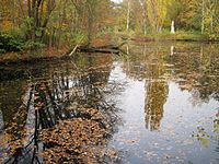
 A small river in autumn
 -
 Winter view from Ahornsteig track
 -
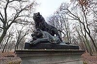 Group of lions sculpture
 -
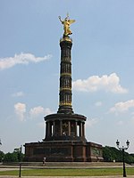 The Victory Column


See also
References
- ^ a b c d e f "Tiergaten". berlin.de. Retrieved 19 February 2018.
- ^ Grésillon, B. (1999). Berlin, cultural metropolis: Changes in the cultural geography of Berlin since reunification. Ecumene, 6(3), 284–294. http://www.jstor.org/stable/44252060
- ^ "On the Desperate Edge of Now", from The Living Dead by Adam Curtis (BBC, 1995).
External links

| International | |
|---|---|
| National | |