
Timanfaya National Park
This article needs additional citations for verification. (April 2014) |
| Timanfaya National Park | |
|---|---|
| Parque Nacional de Timanfaya | |
 | |
_-_OSM_Mapnik.svg) Location of Timanfaya  Timanfaya National Park (Spain, Canary Islands) | |
| Location | Lanzarote, Spain |
| Coordinates | 29°00′N 13°44′W / 29.000°N 13.733°W |
| Area | 51.07 km2 (19.72 sq mi) |
| Established | 1974 |
Timanfaya National Park (
Volcanic activity
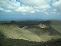
The greatest recorded eruptions occurred between 1730 and 1736. The volcanic activity continues as the surface temperature in the core ranges from 100 to 600 °C (212 to 1,112 °F) at the depth of 13 metres (43 ft), which is demonstrated by pouring water into the ground, resulting in a geyser of steam which is an attraction for tourists.[3] There is only one active volcano, Timanfaya volcano, after which the park is named.
-
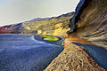 Charco de los Clicos
 -

-
 Timanfaya
 -
 Timanfaya
 -

-
 El Diablo


Ecological value

In 1993,
Access to the park by the public is strictly regulated to protect the delicate flora and fauna. There are one or two footpaths, and a popular short route where one can visit by camel. There is a public car park from which one can tour the volcanic landscape by coach using a road that is otherwise closed to the public.

References
- ^ "Protected Natural Areas". Gobierno de Canarias. Archived from the original on 24 September 2015.
- ^ "Timanfaya". Gobierno de Canarias. Retrieved 14 January 2021.
- ^ "The Geology of the Canary Islands - 1st Edition". www.elsevier.com. Retrieved 2020-10-13.
External links
 Media related to Parque Nacional de Timanfaya at Wikimedia Commons
- https://www.miteco.gob.es/en/parques-nacionales-oapn/red-parques-nacionales/parques-nacionales/timanfaya.html
- More Information and how to get there
| International | |
|---|---|
| National | |
This Canary Islands location article is a stub. You can help Wikipedia by expanding it. |