
Tirupati district
Tirupati district | |
|---|---|
Tirupati
Lok Sabha list | |
| • Assembly | Assembly list |
| Area | |
| • Total | 8,231 km2 (3,178 sq mi) |
| Population | |
| • Total | 2,196,984 |
| • Density | 270/km2 (690/sq mi) |
| Languages | |
| • Official | Telugu |
| • Regional | |
UTC+5:30 (IST) | |
| Postal Index Number | 517XXX, 524XXX |
| Website | tirupati |
Tirupati district (ⓘ) is one of the eight districts of Rayalaseema region in the Indian state of Andhra Pradesh. The district headquarters is located at Tirupati city. This district is known for its numerous historic temples, including the Hindu shrine of Tirumala Venkateswara Temple and Sri Kalahasteeswara temple. The district is also home to Satish Dhawan Space Centre (formerly Sriharikota Range), a rocket launch centre located in Sriharikota. The river Swarnamukhi flows through Tirupati, Srikalahasti , Naidupeta, Vakadu and join into the Bay of Bengal.
The district is an educational hub and has central and state universities and institutes including
Etymology
The district derived its name from its main city, Tirupati. In Tamil translation, tiru means sacred or Lakshmi and pati means abode or husband.[5][6][7]
History
On 26 January 2022, Balaji district was proposed to be formed from parts of Chittoor, Nellore districts as one of the twenty-six districts.[8] Based on the feedback from public, the name was later changed to Tirupati district. The new district came into existence on 4 April 2022 with Gudur, Sullurupeta revenue divisions from Nellore district and Tirupati revenue division from Chittoor district. Srikalahasti revenue division was newly created.[9][10][11]
Geography
Tirupati district is located between the northern latitudes of 13°21′54″ and 14°30′40″ and between the eastern longitudes 79°5′42″ and 80°4′10″. It is bordered by SPSR Nellore district to the north, Chittoor and Annamayya districts to the west , Chittoor and Tiruvallur district of Tamil Nadu to the south and Bay of Bengal to the east.[12]
The river Swarnamukhi flows through Tirupati, Srikalahasti and joins with the Bay of Bengal. The major part of Pulicat Lake is in this district.
Demographics
Based on the 2011 census data, Tirupati district had a population of 21,96,984, of which 850,056 (38.69%) lived in urban areas. Tirupati district had a sex ratio of 1000 females per 1000 males. Scheduled Castes and Scheduled Tribes make up 5,19,388 (23.64%) and 1,70,779 (7.77%) of the population respectively.[2]: 92–96 [3]: 82–87 93.75% of the population follow Hinduism, with a small minority follows Islam and Christianity.
88.00% of the population spoke
Politics
The district is part of two parliamentary constituencies and seven assembly constituencies. The parliamentary constituency are
| Constituency number | Name | Reserved for (SC/ST/None) |
Parliamentary constituency |
|---|---|---|---|
| 167 | Tirupati
|
None | Tirupati
|
| 121 | Sullurpeta
|
SC | |
| 122 | Venkatagiri
|
None | |
| 120 | Guduru
|
SC | |
| 168 | Srikalahasti
|
None | |
| 169 | Satyavedu
|
SC | |
| 166 | Chandragiri
|
None | Chittoor |
Administrative divisions

The district is divided into 4 revenue divisions: Gudur, Srikalahasti, Sullurupeta and Tirupati, which are further subdivided into a total of 34 mandals, each headed by a sub-collector.[1]
Mandals
The list of 34 mandals in Tirupati district, divided into 4 revenue divisions, is given below.[15]
Cities and towns
The district has one
| S.No. | Name | Civic status | Revenue division |
Population (2011 census) |
|---|---|---|---|---|
| 1 | Tirupati | Municipal Corporation | Tirupati | 2,95,323 |
| 2 | Srikalahasti | Municipality Grade - 1 | Srikalahasti | 80,056 |
| 3 | Gudur | Municipality Grade - 1 | Gudur | 74,047 |
| 4 | Puttur | Municipality Grade - 3 | Tirupati | 54,092 |
| 5 | Venkatagiri | Municipality Grade - 3 | Gudur | 52,688 |
| 6 | Sullurupeta | Municipality Grade - 3 | Sullurupeta | 45,782 |
| 7 | Naidupeta | Municipality Grade - 3 | Sullurupeta | 45,055 |
Economy
STPI, Tirupati with a 10,000 sq.ft. facility for incubation was started in the year 2002. [16] Sri City, a SEZ was started in the year 2008.
50,000-100,000 devotees visit The Sri Venkateswara Temple at Tirumala everyday, contributing to the tourism driven economy of the district.[17]
Transport
Roadways
NH 16, NH 71, NH 140, NH 716 and NH 565 pass through the district. Six lane express way connecting Tirupati and Bangalore via Chittoor is operational. [18]
Railways

Tirupati railway station is among the busiest railway stations of India. It is on the Renigunta-Katpadi railway line. Renigunta junction,Sullurupeta railway station, Gudur junction and Pakala junction are major railway stations.
Airways

Tirupati Airport, the second-largest airport in Andhra Pradesh, is located 15 km (9.3 mi) from the Tirupati city centre and has daily flights to several domestic destinations. Tirupati Airport is upgraded to an international airport. The new international terminal was inaugurated on 22 October 2015, but as of March 2023[update] is not operational. [19] The nearest operational international airport is Chennai International Airport which is 130 km (81 mi) from Tirupati.
Waterways
Dugarajapatnam Port is a proposed port in the district.[20]
Education
Sri Venkateswara University, Sri Padmavati Mahila Visvavidyalayam, National Sanskrit University,Sri Venkateswara Vedic University, Sri Venkateswara Veterinary University (SVVU) and Krea University are some of the universities in the district.
Several eminent institutes of excellence such as
The National Atmospheric Research Laboratory of the Department of Space is at village Gadanki in Pakala mandal. The lab is involved in carrying out fundamental and applied research in Atmospheric and Space Sciences.[21]
Tourist attractions
-
 Raja Palace, Chandragiri Fort
 -

-
 View of Srikalahasti from Kanappa Hill, Srikalahasti
 -
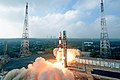 Liftoff from Satish Dhawan Space Centre at Sriharikota
 -
 view of Gudimallam linga,a 19th century replica from the temple located in yerpedu mandal


Notable people
References
- ^ a b c "Tirupati District: At a glance". tirupati.ap.gov.in. Retrieved 4 April 2022.
- ^ a b "District Census Hand Book – Sri Potti Sriramulu Nellore" (PDF). Census of India. Registrar General and Census Commissioner of India.
- ^ a b "District Census Hand Book – Chittoor" (PDF). Census of India. Registrar General and Census Commissioner of India.
- ^ a b c "Table C-16 Population by Mother Tongue: Andhra Pradesh". Census of India. Registrar General and Census Commissioner of India.
- ISBN 9789925082193.
- ^ "Full text of "On the original inhabitants of Bharatavarsa or India"". archive.org. 1893. Retrieved 18 November 2016.
- ^ "Index of /NASD/4a7f1db4-5792-415c-be79-266f41eef20a/upgrade-archive-06-14-2007/data/upload-allbooks/disk 3/Jan N/ENGLISH/The_Dravidians_/TXT". tera-3.ul.cs.cmu.edu. Retrieved 18 November 2016.
- from the original on 26 January 2022. Retrieved 26 January 2022.
- ^ "New districts to come into force on April 4". The Hindu. 30 March 2022. Retrieved 31 March 2022.
- ISSN 0971-751X. Retrieved 7 April 2022.
- Eenadu.net(in Telugu). 31 March 2022. Retrieved 31 March 2022.
- ^ "District profile". Retrieved 21 April 2023.
- ^ "Population by Religion - Andhra Pradesh". censusindia.gov.in. Registrar General and Census Commissioner of India. 2011.
- ^ "District-wise Assembly-Constituencies". ceoandhra.nic.in.
- ^ Sasidhar, B. M. (4 April 2022). "Chittoor, Tirupati, Annamayya districts formed as part of rejig". www.thehansindia.com. Retrieved 6 April 2022.
- ^ "About STPI Tirupati". STPI. Retrieved 21 April 2023.
- ^ "Sri Venkateshwara Swamy Temple". AP Tourism. Retrieved 21 April 2023.
- ^ "List of National Highways passing through A.P. State". Roads and Buildings Department. Government of Andhra Pradesh. Archived from the original on 28 March 2016. Retrieved 22 February 2016.
- ^ "Tirupati International Airport inauguration on Vijaya Dasami". The hindu. Retrieved 12 October 2015.
- ^ "Decks cleared for Dugarajapatnam port". The Times of India.
- ^ "about us". NARL. Retrieved 22 April 2023.
External links
 Media from Commons
 Travel information from Wikivoyage
 Data from Wikidata
- Mandals of Tirupati district - Overpass turbo OSM interactive map
- Railways in Tirupati district - Overpass turbo OSM interactive map
Places adjacent to Tirupati district | ||||||||||||||||
|---|---|---|---|---|---|---|---|---|---|---|---|---|---|---|---|---|
| ||||||||||||||||