
Tlaxcala (city)
Tlaxcala | |
|---|---|
Municipality | |
| Tlaxcala de Xicohténcatl | |
Our Lady of the Assumption Cathedral, University Cultural Center of UATX , San José Parish, cityscape overview | |
|
UTC-5 (Central) | |
| Postal code (of seat) | 90000 |
| Area code | 246 |
| Website | http://www.capitaltlaxcala.gob.mx/ |
Tlaxcala (
History


The name Tlaxcala most likely comes from a Nahuatl phrase which means “place of corn bread.” The Aztec glyph for the Mesoamerican dominion is two hills from which emerge a pair of hands making a tortilla.[1]
The site of the modern city did not have a settlement for most of the pre Hispanic era. The area was ruled by a coalition of four dominions called
As the
Despite the military alliance of the Tlaxcalans, they did not have a single capital. After the Spanish conquest terminated, the Europeans selected the current site to solidify their hold on the Tlaxcalans as well as have a base for evangelization. The most likely time that the city was founded was spring of 1522.[1] Tlaxcala was the fifth diocese to be established in the Americas and the second in Mexico after Yucatán. The first bishop was Julian Garces and the seat was established in 1527. However, since there was a cathedral in the city of Puebla and not in Tlaxcala, the seat was moved to Puebla in 1539 and has remained there since. The original territory of the diocese included the states of Puebla, Tlaxcala, Veracruz, Tabasco, Hidalgo and Guerrero, but as new diocese were erected, the territory reduced to the present, states of Puebla and Tlaxcala. In 1903, the name of the Diocese of Tlaxcala was changed to the Diocese of Puebla.[2]
At the time of the Spanish conquest, the Tlaxcala area was heavily populated but with epidemics, emigrations and the construction of the Nochistongo canal to drain the
In 1692, a revolt occurred against Governor Manuel de Bustamante y Bustillo due to the scarcity of grain.[1]
The city of Tlaxcala became a municipality in 1813, under the Spanish Constitution of 1812.[1]
French forces were forced out of the city in 1867 after which Tlaxcalan forces went with
During the end of the 19th century, the politics of the city were dominated by Próspero Cahuantzi, who promoted public works such as kiosks, streets, public markets, bridges and government buildings. The city changed from oil lamps to electric light in the historic center, the state government palace was remodeled and the Xicohtencatl Theatre was built. Electricity for the city was generated through a hydroelectric works in a canal on the Los Negros River.[1]
After the Mexican Revolution, the city recovered and began to grow again, reaching a population of 6,000 by 1927. In the mid 20th century, public education was enhanced at the middle and high school levels. More public works were undertaken to give the city the appearance it has today.[1]
The city

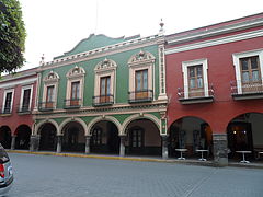
The city center is compact and filled with colonial era building painted in colors such as burnt umber, salmon pink and mustard yellow.
The Portal Hidalgo is on the east side of the main square, built as commercial space in 1550. It is still used as such today although the structures have been modified since then as seen in the differences in the columns and sizes of the arches. The city hall was moved from its centuries old home in the “Casas Reales” to this complex. The interior is dominated by the city council chamber (Salón de Cabildos) along with various municipal offices. On the lower level inside its section of the arches, there is a cultural space called “La Tlaxcalteca” which sells regional handcrafts and other goods as well as books about Tlaxcala's history.[1]
Historic buildings
The Capilla Real de Indias or Royal Indian Chapel was built in the 16th century as a church for indigenous nobility. At the end of the 18th century, a fire destroyed the nave and much of the rest collapsed as a result of an earthquake. The ruins remained abandoned until the structure was restored in 1984 to house the state's judicial branch.[4]
The Casa de Piedra ("Stone House") is located on the southwest corner of the main plaza. It was built in the 16th century as a notary office and home. Its name comes from the solid gray sandstone used in its construction, unique to the area.[4]
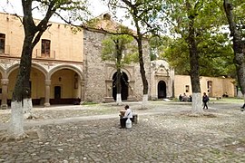
- Franciscan monastery
The former
The Jorge Aguilar “El Ranchero” Bullring is on a site next to the former monastery. It was one of the first established in Tlaxcala in 1788. In 1817, the current structure was built of adobe and stone. The popularity of the sport spurred a number of ranches dedicated to raising bulls including the Tepeyahualco, Piedras Negras and Mimiahuapan. It is located next to the former monastery and also serves as the site for the annual Tlaxcala Fair.[4][1]
The State Government Palace is the most important civic construction from the 16th century. It has three sections. The east wing was known as the Casas Reales, the center Casas Consistoriales and the west wing as the Alhóndiga. The building is used for state government offices. The interior contain a number of murals by Desiderio Hernández Xochitiotzin, which depict the history of Tlaxcala.[4]

- San José parish church
The San José parish church was originally called the parish of San Juan y San José (Saints John and Joseph), constructed during the 18th century in Baroque style. This site was once the cathedral of the Diocese of Tlaxcala, but this has since been merged with

The former municipal palace was constructed in the middle of the 16th century as a place for the representatives of the four Tlaxcala dominions to meet. It has two levels with arches on the lower level of the façade. The main entranceway has three arches with reliefs over stone columns. The upper level of the façade has a seal and a pediment with clock. The interior has a terrace with three arches supported by Tuscan columns. The main stairway has a relief depicting Xicohtencatl Axayacatzin as well as reliefs of the four Tlaxcalan leaders at the time of the Spanish arrival.[1]
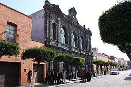
The Former Legislative Palace is now home to the state's Secretary of Tourism. It was built in the 19th century with a façade of gray sandstone supported by pilasters with capitols. The building functioned as the site of the state's legislature from 1901 to 1982.[4]

The Xicohtencatl Theatre was built in 1873 with one of its early main productions being a re-enactment of the Battle of Puebla. Built during the Porfirio Díaz period, it was remodeled after the Mexican Revolution to Neoclassical from 1923 to 1945. The latest restoration of the building occurred in 1984 done by the Instituto Tlaxcalteca de Cultura. The Xicohtencatl. It has a sandstone façade, which is principally in Neoclassical style. This façade has twelve pilasters with Corinthian capitols that mark off the windows, doors and niches. The lower level has three entrances and the upper level has three balconies with arches. The interior has a ceiling with a large soffit with an Art Nouveau style painting by John Fulton representing the Muses along with Tlaxcala landscapes.[4][1]
The Tlaxcala Museum of Art was inaugurated in 2004, located in a building constructed in the 19th century in the historic center. This building originally was a hospital and later jail. When it was restored and converted to its current use, the façade and layout of the building was left intact with only minor changes. The museum has six main halls for permanent exhibits and five for temporary ones.[6]
The Culture Palace is a late Neoclassical building which was begun in 1939. It has a brick façade with a woven mat design interspersed with ornamental gray sandstone. It was originally built to be the middle and preparatory school for the state, but later it was converted into a department of the
The Stairway of the Heroes was initially called the “Stairway of Independence” both of which refer to the busts of figures such as

Plaza Xicohténcatl was created in the late 20th century for a weekend arts and crafts market. In the colonial period, the area was used for the sale of slaves according to some historians. Calzada de San Francisco is a pedestrian street at the southeast side of the plaza, filled with ash trees and paved with blocks of sandstone. As the road leads up to the former monastery, it ends at a gate with three arches.[4]
La Chichita is the name of a fountain found at the intersection of Vicente Guerrero and Porfirio Díaz streets. It is fed by a natural water flow and used to be the source of potable water for the surrounding area.[4]
- Tizatlán Open Chapel
The Tizatlán Open Chapel was built in the 16th century over a pyramid platform which was part of the palace of Xicohtencatl the Elder. This building appears in the
The Chapel of the Well of the Miraculous Water (Capilla del Pocito de Agua Milagrosa) is a small building at a fresh water spring. It began as a wall built to protect the spring at the end of the 17th or beginning of the 18th century. The chapel building dates from between 1892 and 1896 but the entrance arch is older. It has an octagonal layout. One of the walls contains an oil by Isauro G. Cervantes from 1913 and the rest of the walls have murals with Biblical scenes related to water done by Desiderio Hernández Xochitiotzin and Pedro Avelino. Traditionally, red pottery ducks are sold in the small atrium as object of devotion or for healing.[1]
The Chapel of San Nicolasito was originally constructed of wood in the 16th century dedicated to Nicholas of Tolentino. In the 19th century the chapel was reconstructed to what is now one of the side chapels. Little by little it was enlarged to its present size.[1]
The San Esteban Temple was constructed from sandstone in the 20th century in Neoclassical style. Its atrium serves as a cemetery and its interior has a mural depicting the baptism of the four indigenous lords of Tlaxcala in the 16th century.[1]
The San Buenaventura Atempan hermitage was constructed around the time that Cortés was building the brigantines to invade Tenochtitlan. At that time, the structure was in a very rural area. Over the centuries it was abandoned and crumbled with only some of the walls remaining. Some of its images and other objects can now be found at a new temple nearby.[1]
Events
The city celebrates Carnival starting the Friday before Ash Wednesday, with the burning of an effigy to represent “bad humor” accompanied by funeral music. The following day, the queen of the carnival is selected. The main parade with floats occurs on Tuesday. During the long weekend there are various other events such as dance contests and recitals of traditional dance such as that of the Huehues from the community of Acuitlapilco. On Ash Wednesday, ceremonies end with a hanging of an effigy called “La Octava del Carnaval” Often the image is satirical, and of a person considered worthy of criticism.[1]
The Feria de Todos Santos is an important event, dedicated to the agriculture, handcrafts and industry of the state. It also has cultural events such as concerts, art exhibits and dance as well as regional food and an inaugural parade.[1]
The municipality

The city is the governing authority for itself and fifteen other communities, forming a territory of 41.61 square kilometres (16.07 square miles).
The municipality has a very low level of socioeconomic marginalization, with no community having a state of medium and high marginalization. There are 23,035 residences as of 2010[update].[7]
Significant communities outside the municipal seat include Ocotlán, San Estebán Tizatlán, San Gabriel Cuauhtla, San Hipólito Chimalpa, San Lucas Cuauhtelupan and Santa Maria Acuitlapilco.
Geography
.jpg)
The city is located in the central Mexican highlands 2,239 metres (7,346 feet)
Hydrography
The main river in the municipality is the Zahuapan, which is part of the Balsas River region and the basin of the Atoyac River. Other rivers include the Huizcalotla, Negros, Tlacuetla and Lixcatlat. There are remnants of the former lake of Acuitlapilco as well. Other sources of fresh water include a spring in Acuitlapilco and a stream in Tepehitec which runs during the rainy season.[1]
Flora and fauna
The higher elevations of the municipality have forests of pine, holm oak and white cedar. The mid range elevations are mostly secondary vegetation dominated by bush and low growing trees. The flat areas are dominated by a number of dry tolerate plants such as agave, nopal cactus and grasses. Because of the expansion of the urban area, the municipally only has small mammals such as rabbits, squirrels and opossums, along with some species of birds and reptiles as wildlife.[1]
Climate
The climate is a temperate
| Month | Jan | Feb | Mar | Apr | May | Jun | Jul | Aug | Sep | Oct | Nov | Dec | Year |
|---|---|---|---|---|---|---|---|---|---|---|---|---|---|
| Record high °C (°F) | 28.4 (83.1) |
31.0 (87.8) |
35.0 (95.0) |
34.0 (93.2) |
39.2 (102.6) |
34.0 (93.2) |
30.0 (86.0) |
31.0 (87.8) |
31.0 (87.8) |
36.5 (97.7) |
29.2 (84.6) |
30.0 (86.0) |
39.2 (102.6) |
| Mean daily maximum °C (°F) | 22.1 (71.8) |
23.5 (74.3) |
25.9 (78.6) |
27.3 (81.1) |
27.5 (81.5) |
25.4 (77.7) |
24.5 (76.1) |
24.7 (76.5) |
23.9 (75.0) |
24.3 (75.7) |
23.5 (74.3) |
22.3 (72.1) |
24.6 (76.3) |
| Daily mean °C (°F) | 12.5 (54.5) |
13.6 (56.5) |
15.8 (60.4) |
17.7 (63.9) |
18.6 (65.5) |
18.2 (64.8) |
17.3 (63.1) |
17.5 (63.5) |
17.3 (63.1) |
16.5 (61.7) |
14.5 (58.1) |
13.0 (55.4) |
16.0 (60.8) |
| Mean daily minimum °C (°F) | 2.9 (37.2) |
3.7 (38.7) |
5.8 (42.4) |
8.0 (46.4) |
9.8 (49.6) |
11.1 (52.0) |
10.2 (50.4) |
10.3 (50.5) |
10.6 (51.1) |
8.7 (47.7) |
5.4 (41.7) |
3.6 (38.5) |
7.5 (45.5) |
| Record low °C (°F) | −5.0 (23.0) |
−4.0 (24.8) |
−1.9 (28.6) |
0.0 (32.0) |
2.5 (36.5) |
3.0 (37.4) |
4.0 (39.2) |
2.4 (36.3) |
−0.5 (31.1) |
−0.3 (31.5) |
−4.5 (23.9) |
−7.4 (18.7) |
−7.4 (18.7) |
| Average precipitation mm (inches) | 8.7 (0.34) |
7.4 (0.29) |
10.4 (0.41) |
31.1 (1.22) |
74.8 (2.94) |
158.1 (6.22) |
156.4 (6.16) |
162.2 (6.39) |
140.0 (5.51) |
68.0 (2.68) |
11.1 (0.44) |
6.3 (0.25) |
834.5 (32.85) |
| Average precipitation days (≥ 0.1 mm) | 1.4 | 1.5 | 2.5 | 6.6 | 12.2 | 17.4 | 19.0 | 19.0 | 16.8 | 9.0 | 2.5 | 1.2 | 109.1 |
| Average relative humidity (%)
|
70 | 67 | 66 | 67 | 69 | 75 | 77 | 77 | 79 | 74 | 70 | 73 | 72 |
| Mean monthly sunshine hours | 218 | 220 | 251 | 218 | 196 | 154 | 167 | 174 | 176 | 221 | 226 | 216 | 2,437 |
| Source 1: Servicio Meteorológico National (humidity 1981–2000)[8][9] | |||||||||||||
| Source 2: Deutscher Wetterdienst (sun, 1961–1990)[10][a] | |||||||||||||
Main milestones
-
 City Hall complex
 -

-

-
 Xicotencatl Theatre
 -
 Museum of the Memory
 -
 The bullring "Jorge "Rancher" Aguilar" and church
 -
 Del Buen Vecino Church
 -
 First convent in the continental Americas in Tlaxcala, named for the Assumption
 -
 Aqueduct
 -
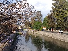 Zahuapan River, channeled by the Spanish
 -

-
 Escalinatas de los Héroes
 -
 Statue of Tlahuicole

.jpg)


.jpg)

Twin towns and sister cities
References
- ^ a b c d e f g h i j k l m n o p q r s t u v w x y z aa ab ac ad ae af ag "Tlaxcala". Encyclopedia de los Municipios y Delegaciones de México – Estado de Tlaxcala (in Spanish). Mexico: INAFED Instituto para el Federalismo y el Desarrollo Municipal and SEGOB Secretaría de Gobernación. 2010. Archived from the original on March 6, 2012. Retrieved March 11, 2012.
- ^ a b "Tlaxcala". New Advent Catholic Encyclopedia. Retrieved March 11, 2012.
- ^ a b c Freda Moon (November 23, 2011). "An Old-World Escape Near Mexico City". New York Times. Retrieved March 11, 2012.
- ^ a b c d e f g h i j k l "Tlaxcala" (in Spanish). Mexico: Secretaría de Turismo de Tlaxcala. 2011. Retrieved March 11, 2012.
- ^ a b c "El Museo Regional de Tlaxcala cumple 30 años difundiendo cultura" [The Tlaxcala Regional Museum completes thirty years of diffusing culture] (Press release) (in Spanish). INAH. March 25, 2011. Retrieved March 11, 2012.
- ^ "Museo de Arte de Tlaxcala (MAT)". Sistema de Información Cultural (in Spanish). Mexico: CONACULTA. Retrieved March 11, 2012.
- ^ a b c "Resumen municipal Tlaxcala" [Municipal summary Tlaxcala] (in Spanish). Mexico: SEDESOL. Retrieved March 11, 2012.[permanent dead link]
- ^ "Estado de Tlaxcala–Estacion: Tlaxcala de Xicontecatl (DGE)". NORMALES CLIMATOLÓGICAS 1951–2010 (in Spanish). Servicio Meteorológico National. Archived from the original on 18 May 2015. Retrieved 7 May 2015.
- ^ "NORMALES CLIMATOLÓGICAS 1981–2000" (PDF) (in Spanish). Servicio Meteorológico Nacional. Archived from the original (PDF) on 18 May 2015. Retrieved 7 May 2015.
- ^ "Station 76683 Tlaxcala, TLAX". Global station data 1961–1990—Sunshine Duration. Deutscher Wetterdienst. Archived from the original on 2017-10-17. Retrieved 7 May 2015.
- ^ a b c d e f g h i Muñetón, Karla (September 15, 2019). "Tiene ciudad capital 10 hermanamientos". El Sol de Tlaxcala. Retrieved September 11, 2019.
- ^ "Maroc-Mexique: développer une coopération tous azimuts". Menara. Archived from the original on November 23, 2004. Retrieved November 24, 2004.
- ^ "Ayuntamiento Constitucional de Tlaxcala, Estado de Tlaxcala, Estados Unidos Mexicanos, Acta de sesión extraordinaria". Ayuntamiento de Tlaxcala. October 10, 2007. Archived from the original on May 25, 2015. Retrieved June 30, 2014.
- ^ "Saltillo tiene pacto de hermanamiento con 15 ciudades... solo con Austin mantiene contacto". vanguardia.com.mx. October 26, 2019. Retrieved November 14, 2019.
- ^ "Se Hermanan las Ciudades de la Villa y Tlaxcala". colimanoticias.com. December 6, 2019. Retrieved November 20, 2019.
- ^ "Ixtaczoquitlán, hermanado con más de diez ciudades". Política en Red. July 11, 2012. Archived from the original on June 11, 2012. Retrieved May 23, 2014.
Notes
- ^ Station ID for Tlaxcala, TLAX is 76683 Use this station ID to locate the sunshine duration
Further reading
- . Encyclopædia Britannica. Vol. 26 (11th ed.). 1911. p. 1034.
- .
Tlaxcala de Xicohténcatl (capital) | ||
| Cities |  | |
| Municipalities | ||
| History | ||
| Sights | ||
|
| International | |
|---|---|
| National | |
| Other | |