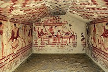
Tomb of the Triclinium


The Tomb of the Triclinium (
Since its discovery in 1830,[3] the tomb's frescoes have deteriorated and lost some of their color and detail. In 1949 they were moved to the Tarquinia National Museum to conserve them. Thanks to watercolor copies made by Carlo Ruspi shortly after the tomb's discovery, it is still possible to see the frescoes in their former state.[3] The artistic quality of the frescoes has been described as superior to many other Etruscan tombs,[2] and is thought that the artist who decorated the tomb was a Greek metic.[2]
Description

The tomb consists of a single room. The fresco on the back wall shows a
The similarities between the frescoes in the Tomb of the Triclinium and Tomb 5513 (also in the Necropolis of Monterozzi) led Steingraber to conclude that they were the products of the same workshop. The strong influence of red-figure Attic vase painting has convinced some experts that the artist who decorated the tomb was a Greek metic.[2]
See also
References
- ^ "Corneto", Encyclopaedia Britannica, 9th ed., 1878.
- ^ ISBN 978-0-89236-865-5.
- ^ ISBN 978-0-89236-600-2.
