
Tonto National Monument
| Tonto National Monument | |
|---|---|
 Lower Cliff Dwelling | |
  | |
| Location | Gila County, Arizona, USA |
| Nearest city | Globe, Arizona |
| Coordinates | 33°39′25″N 111°5′40″W / 33.65694°N 111.09444°W |
| Area | 1,120 acres (4.5 km2)[1] |
| Created | December 19, 1907 |
| Visitors | 31,504 (in 2022)[2] |
| Governing body | National Park Service |
| Website | Tonto National Monument |
Tonto National Monument is a
Cliff dwellings
Well-preserved cliff dwellings were occupied by the Salado culture during the 13th, 14th, and early 15th centuries. The people farmed in the Salt River Valley, and supplemented their diet by hunting and gathering native plants. The Salado were fine craftspeople, producing some of the most flamboyant polychrome pottery and intricately woven textiles to be found in the Southwest. Some of the artifacts excavated nearby are on display in the visitor center museum.
The
Natural history
The National Monument is surrounded by the
The Upper Sonoran
It also serves as a home for native animals such as whitetail and mule deer, mountain lion, bobcat, three rattlesnake species and many more.
Wilderness areas
The area around Tonto National Monument also includes several designated


Photo gallery


-
 Landsat 7 image of Tonto National Monument (right center), and the surrounding area
 -
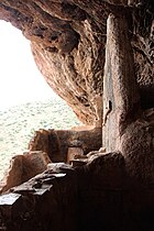
 Tonto National Monument, AZ, Room detail
 -
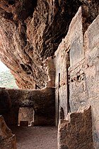
 Tonto National Monument, AZ, room detail
 -
 Tonto National Monument, AZ, room detail
 -
 Tonto National Monument, AZ, Room detail
 -
 Tonto National Monument, AZ, hand prints on wall
 -
 Tonto National Monument, AZ, looking west
 -
 Tonto National Monument, AZ, looking along west face
 -
 Tonto National Monument, looking east


See also
Notes
- ^ All three NRHP-listed areas are included within the National Monument, but the National Monument itself is not NRHP-listed
References
- ^ "Listing of acreage – December 31, 2011" (XLSX). Land Resource Division, National Park Service. Retrieved May 14, 2012. (National Park Service Acreage Reports)
- ^ "NPS Annual Recreation Visits Report". National Park Service. Retrieved July 23, 2023.
- ^ Roosevelt 1 WNW, Arizona – Climate Summary. Western Regional Climate Center.
- ^ a b "National Register Information System". National Register of Historic Places. National Park Service. March 13, 2009.
- "Tonto National Monument, Arizona". NASA Earth Observatory. Archived from the original on September 5, 2005. Retrieved May 5, 2006.