
Topatopa Mountains
This article needs additional citations for verification. (July 2021) |
| Topatopa Mountains[1] | |
|---|---|
| Topa Topa Mountains | |
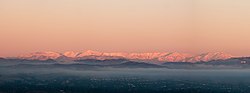
 "The Pink Moment" on the Topa Topa bluffs, as viewed from Upper Ojai. | |
| Highest point | |
| Peak | Cobblestone Mountain |
| Elevation | 6,738 ft (2,054 m) |
| Coordinates | 34°31′48″N 119°02′35″W / 34.530°N 119.043°W |
| Geography | |
![Topatopa Mountains[1] is located in California](/File:Relief_map_of_California.png) Topatopa Mountains[1] | |
| Country | United States |
| State | Sierra Madre Mountains |
The Topatopa Mountains are a mountain range in Ventura County, California, north of Ojai, Santa Paula, and Fillmore. They are part of the Transverse Ranges of Southern California.
Etymology
A name for the mountains was first inscribed within the archives of
Geography
The Topatopa Mountains lie in an east–west direction east of the
Hydrology
Several major tributaries of the Santa Clara River flow down from the Topatopa Mountains, the largest being Piru Creek and Sespe Creek.
Lake Piru is the only major reservoir located within the mountains.
Natural history
The Topatopa Mountains are within the southern Los Padres National Forest. The Sespe Wilderness Area, and the Sespe Condor Sanctuary, are primarily within the Topatopa Mountains and foothills. They are part of the home range of the endangered California condor.
The habitat is of the California montane chaparral and woodlands ecoregion. Sespe Creek flows through the range, creating Sespe Gorge, with Riparian habitats of willows and woodlands.
-
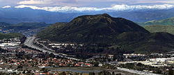
 Northeastern face as viewed from Santa Clarita.
 -
 View from Fillmore of the Topatopa Mountains, with San Cayetano Mountain at center.
 -
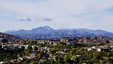
 The southeastern face of the Topatopa Mountains as seen from Santa Clarita Valley.
 -
 View from Newbury Park with Conejo Mountain in front and the Topatopa skyline behind.
 -
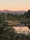 "The Pink Moment" on Chief Peak, as seen from across a vernal pool atOjaiMeadows Preserve.


Highest peaks
- Cobblestone Mountain 6,738 ft (2,054 m)
- Hines Peak - 6,703 ft (2,043 m)
- Topatopa Bluff - 6,367 ft (1,941 m)
- Chief Peak - 5,560+ ft (1,695+ m)
- Santa Paula Peak - 4,957 ft (1,511 m)
- Nordhoff Peak - 4,485 ft (1,367 m)
Adjacent Transverse Ranges
- San Emigdio Mountains - to the north
- Pine Mountain Ridge - to the north and northwest
- OjaiValley
- Sierra Madre Mountains- to the west
- Santa Ynez Mountains - to the southwest
- Santa Susana Mountains - to the southeast
- Sierra Pelona - to the east
- Tehachapi Mountains - to the northeast
See also
- Fishes of Sespe Creek, California
- Piru Creek
![]() Media related to Topatopa Mountains at Wikimedia Commons
Media related to Topatopa Mountains at Wikimedia Commons
References
- ^ "Topatopa Mountains". Geographic Names Information System. United States Geological Survey, United States Department of the Interior.
- ^ "HPS Summit Signatures - Topotopa Bluff". www.hundredpeaks.org. Retrieved 2021-11-04.
- ^ "Cobblestone". NGS Data Sheet. National Geodetic Survey, National Oceanic and Atmospheric Administration, United States Department of Commerce. Retrieved 2014-03-02.
This Ventura County, California–related article is a stub. You can help Wikipedia by expanding it. |