
Torres del Paine National Park
| Torres del Paine National Park | |
|---|---|
Corporación Nacional Forestal |

Torres del Paine National Park (
Torres del Paine National Park is part of the Sistema Nacional de Áreas Silvestres Protegidas del Estado de Chile (National System of Protected Forested Areas of Chile). In 2013, it measured approximately 181,414 hectares (700 sq mi).[1] It is one of the largest and most visited parks in Chile. The park averages around 252,000 visitors a year, of which 54% are foreign tourists,[2] who come from many countries all over the world. It is also part of the End of the World Route, a tourist scenic route.
The park is one of the 11 protected areas of the Magallanes Region and Chilean Antarctica (together with four national parks, three national reserves, and three national monuments). Together, the protected forested areas comprise about 51% of the land of the region (6,728,744 hectares (25,980 sq mi)).
The Torres del Paine ("Towers of Paine") are the distinctive three
History

Lady Florence Dixie, in her book published in 1880, gave one of the first descriptions of the area and referred to the three towers as Cleopatra's Needles.[5] She and her party are sometimes credited as being the first "foreign tourists" to visit the area that is now called Torres del Paine National Park.[6]
Several European scientists and explorers visited the area in the following decades, including
.The park was established on 13 May 1959[7] as Parque Nacional de Turismo Lago Grey (Grey Lake National Tourism Park) and was given its present name in 1970.[6]
In 1976, British mountaineer John Garner and two Torres del Paine rangers, Pepe Alarcon and Oscar Guineo pioneered the Circuit trail which circles the Paine massif.[8]
In 1977,
Fires
In 1985, a tourist started a fire that burned about 150 km2 (58 sq mi) of the park. The blaze affected the areas east and south around Lake Pehoé.[11]
In February 2005, an accidental fire started by a Czech backpacker, which lasted for about ten days, destroyed 155 km2 (60 sq mi) of the park,[11] including about 2 km2 of native forest. The Czech government offered aid after the fire and donated US$1 million to reforestation efforts.[12]
In late December 2011 through January 2012, an Israeli backpacker was charged of having started a fire after being caught by a park ranger when lighting up some paper roll in a forbidden area.
In 2019 an incipient wildfire caused by a
Nevertheless, recent paleoenvironmental studies performed within the Park indicate that fires have been frequent phenomena at least during the last 12,800 years.[20]
Climate

According to the Köppen climate classification, the park lies in the “temperate climate of cold rain without a dry season." The meteorological conditions of the park are variable due to the complex orography.
The park is famous for its strong winds. The windiest months are November - January,[21] which coincides with the peak tourism season.
Temperatures
The zone is characterized by cool summers, with temperatures lower than 16 °C (61 °F) during the warmest month (January). Winter is relatively cold, with an average high temperature in July of 5 °C (41 °F), and an average low of −3 °C (27 °F).[22]
Precipitation
The rainiest months are March and April, with a monthly average rainfall of 80 mm. This represents double the July–October (winter) rainfall, which are the drier months. A study of the exact chemical components of the precipitation in the park has been carried out.[23]
Hydrology
The park possesses a large drainage network, which consists of numerous rivers, streams, lakes, ponds, and cascades that come from the
The Southern Patagonian Ice Field takes up the entire western side of the park. The Southern Patagonian Ice Field feeds four main glaciers; they are from north to south the glaciers: Dickson, Grey, Zapata, and Tyndall. This last glacier is rapidly receding. The largest is Glacier Grey. It is divided into two arms, because of the appearance of a peninsula of ice, commonly called the Island or Nunatak, that becomes apparent a little more with each year that passes. The eastern arm measures about 1.2 km while the western has a width of around 3.6 km. The longitude of the glacier in its path towards the interior of the park is 15 km.
Studies of the glaciers in the park have given scientists a clearer picture of the epochs of the earth, or what happened after the last glacial age.[24][25][26]
Geography

The landscape of the park is dominated by the Paine massif, which is an eastern spur of the
The head of French Valley is a cirque formed by tall cliffs. The colossal walls of Cerro Cota 2000 and Cerro Catedral punctuate the western region of the Valley. Cerro Cota 2000 is named for its elevation; its highest contour line is about 2,000 m (6,562 ft). Cerro Catedral is named so because its east face resembles a cathedral's facade. To the north stands the granite arête called Aleta de Tiburón (English: Shark's Fin). To the east, from north to south, lie the peaks Fortaleza (Fortress), La Espada (The Sword), La Hoja (The Blade), La Máscara (The Mummer), Cuerno Norte (North Horn), and Cuerno Principal (Main Horn).
In the Valley of Silence, the gigantic granite walls of Cerro Fortaleza and Cerro Escudo (Shield Mountain) stand face to face with the western faces of the Torres del Paine. Ascencio Valley is the normal route to reach the Torres del Paine lookout, which is located at the bank of a milky green
The Southern Patagonian Ice Field mantles a great portion of the park. Glaciers include the Dickson, the Grey, and the Tyndall.
Among the lakes are the Dickson Lake, Nordenskjöld Lake, Lake Pehoé, Grey Lake, Sarmiento Lake, and Del Toro Lake. Only a portion of the latter is within the borders of the park. All are vividly colored, most due to rock flour suspended in their waters. The main river flowing through the park is Paine River. Most of the rivers and lakes of the park drain into Última Esperanza Sound via Serrano River.
.jpg)
Geology
Much of the geology of the Paine Massif area consists of
In June 2014, scientists uncovered
During the
IUGS geological heritage site
In respect of it being 'a world class site for the study of structurally controlled emplacement and construction of shallow bimodal laccoliths', the International Union of Geological Sciences (IUGS) included 'The Miocene Torres del Paine intrusive complex' in its assemblage of 100 'geological heritage sites' around the world in a listing published in October 2022. The organisation defines an IUGS Geological Heritage Site as 'a key place with geological elements and/or processes of international scientific relevance, used as a reference, and/or with a substantial contribution to the development of geological sciences through history.'[34]
Biology

Flora
The last study of significant scope carried out concerning the flora of the park was realized by Pisano in 1974. This study examined four biotic zones that made up the territory of the park, determined by their vegetational type.
Torres del Paine National Park is adorned with beautiful vegetation, including the evergreen Embothrium coccineum, which produces vivid red flowers grouped in corymbs, and Calceolaria uniflora, of striking shape and colors.
The park has 7 documented species of
In the park 85 non-native plant species have been recorded, of which 75 are of European origin and 31 are considered to be invasive.[36]
The park contains four vegetation zones:
A study on the beech trees and forest regeneration patterns in the park was published in 1992.[38]
Fauna
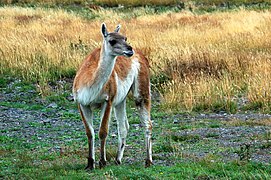
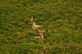
The park contains breeding populations of 15
- Fauna in Torres del Paine National Park
-
-

-
-

-
 Crested Caracara


Tourism
.jpg)
The national park has over 252,000 visitors per year.[2] It is a popular hiking destination in Chile. There are clearly marked paths and many refugios which provide shelter and basic services. Hikers can opt for a day trip to see the towers, French Valley or Glacier Grey or a multi-day trek. Multi-day treks include the popular "W" route, which takes about three to five days, and the full circuit or "O" route, which typically takes 7 to 9 days.[42] The Refugio locations also have campsites and tent for hire. Cooking with a camping stove is not permitted except in Refugio locations. Camping is only allowed at specified campsites and wood fires are prohibited throughout the park. Since October 2016, it is mandatory to book campsites or refugios before entering the park.[43][44] For less adventurous visitors, there are several hotels located in and around the park.[45]
A good time to visit Torres del Paine is between October and April because there is less rain. But, during high season the entrance fee is more expensive than between May and September. Some of Torres del Paine National Park attractions are Paine horns which are a group of mountains 2000 meters high in the middle of the W trek. There is a view of Pingo Lake from de Grey Glacier.[46]
Hikers are not allowed to stray from the paths in the national park. The visitor impact on the park has been scientifically measured.[47]
A certified guide is required to access some parts of the park.
Visiting the park is recommended between September and April, during the southern spring, summer, and early autumn. During summer, daylight hours are long given the southern latitude. Outside of this time frame, the weather becomes extreme for the majority of the public. During the southern winter, daylight dwindles to only 8 hours a day.
The park has been elected as the 8th Wonder of the World by
Access routes
The park can be reached by Chile Route 9, which is paved and connects Punta Arenas and Puerto Natales and continues as an asphalt road for 100 km and then becomes a gravel road. In the winter using tire chains is recommended due to unstable climatic conditions. The park can also be reached through maritime and aerial routes. There are buses that leave from Puerto Natales.[49]
See also
References
- ^ a b "CONAF, Por Un Chile Forestal Sustentable" (PDF) (in Spanish). CONAF. May 2013. p. 76. Retrieved 2 April 2017.
- ^ National Forest Corporation (Chile). 2019. p. 3. Retrieved 28 November 2020.
- ^ "Blown Away in Patagonia – Hiking Torres del Paine National Park". GORP.com. Archived from the original on 7 March 2012. Retrieved 2 January 2012.
- ISBN 978-1-84965-356-5. Retrieved 4 August 2015.
- ^ Dixie, Florence, Lady (1880). Across Patagonia.
{{cite book}}: CS1 maint: multiple names: authors list (link) Available at the internet archive. - ^ a b c "History of the park". Official website. National Forest Service. Archived from the original on 25 March 2012. Retrieved 9 June 2011.
- ^ "60th Anniversary of Torres del Paine National Park". www.google.com. Retrieved 16 May 2019.
- ^ "Ice bold". The Sydney Morning Herald. 10 February 2007. Retrieved 13 September 2020.
- ^ "History of Estancia Torres del Paine". Fantastico Sur Lodges. Archived from the original on 20 August 2010. Retrieved 25 May 2010.
- ^ UNESCO Archived 2006-10-10 at the Wayback Machine - Park description at UNESCO World Biosphere Reserve
- ^ a b "Front page". El Mercurio. 2 January 2012.
- ^ "Chile and Czech Republic work to restore Torres del Paine Park — MercoPress". En.mercopress.com. Retrieved 2 January 2012.
- ^ S.A.P, El Mercurio. "La Segunda.com". LaSegunda.com (in Spanish). Retrieved 10 January 2019.
- ISSN 0261-3077. Retrieved 5 November 2023.
- ^ "Chile drops brush fire charges against Israeli". The Jerusalem Post | JPost.com. 9 February 2012. Retrieved 5 November 2023.
- ^ Becerra, Alex; Diaz, Marcos; Zagal, Juan Cristobal. "Feasibility study of using a Small Satellite constellation to forecast, monitor and mitigate natural and man-made disasters in Chile and similar developing countries" (PDF). Archived from the original (PDF) on 16 October 2013. Retrieved 26 March 2013.
- ^ "Cómo el fuego destruye esta reserva de la biósfera". El Mercurio. 2 January 2012.
- ^ "Infografía: Áreas afectadas por el incendio en Torres del Paine". Emol.com. Archived from the original on 8 January 2012. Retrieved 2 January 2012.
- ^ "Incendio en el Parque Torres del Paine fue provocado por un cigarro mal apagado". El Mostrador (in Spanish). 15 January 2019. Retrieved 14 March 2023.
- ^ Francois, J.P. "Historia paleoambiental del ecotono bosque-estepa al interior del Parque Nacional Torres del Paine (Región de Magallanes, Chile) durante los últimos 14.800 años". Thesis.
- ^ "Weather and Climate: Torres del Paine". Weather and Climate. 14 January 2020. Retrieved 14 January 2020.
- ^ "Ecocamp Patagonia". Archived from the original on 2 January 2013. Retrieved 4 December 2012.
- . Retrieved 4 December 2012.
- S2CID 128400121.
- .
- S2CID 67848949. Archived from the originalon 29 June 2012. Retrieved 4 December 2012.
- .
- . Retrieved 4 December 2012.
- ^ Dinosaur graveyard discovered in Chile's Torres del Paine National Park. 4 June 2014. Archived from the original on 14 December 2021 – via YouTube.
- ^ "Video: Dinosaur 'graveyard' discovered in Chile - Telegraph". Telegraph.co.uk. 4 June 2014. Archived from the original on 5 June 2014.
- .
- ^ hdl:10533/129777.
- .
- ^ "The First 100 IUGS Geological Heritage Sites" (PDF). IUGS International Commission on Geoheritage. IUGS. Retrieved 13 November 2022.
- ^ Domínguez, Erwin (2004). "Catálogo preliminar de la familia Orchidaceae del Parque Nacional Torres del Paine, XII Región, Chile". Chloris Chilensis. 7 (1). Retrieved 1 November 2007.
- .
- ^ "Torres del Paine National Park (Official GANP Park Page)". national-parks.org. Retrieved 8 July 2022.
- S2CID 24147789.
- ^ "A Wild But Fragile Chile: Torres del Paine National Park". Sounds and Colours. 22 August 2011. Archived from the original on 2 October 2012. Retrieved 23 August 2011.
- S2CID 86558711.
- .
- ^ "Torres del Paine Circuit Trek". backpackers-review.com. 8 January 2018. Retrieved 5 March 2019.
- ^ "Fantastico Sur". Retrieved 4 December 2012.
- ^ "Vertice Patagonia". Retrieved 4 December 2012.
- ^ "Accommodation". TorresDelPaine.com. Retrieved 2 April 2017.
- ^ "Attractions". sayhueque.com. Retrieved 17 February 2022.
- S2CID 145269658.
- ^ "About Us". Parque Nacional Torres del Paine. Archived from the original on 30 October 2020. Retrieved 2 April 2017.
- ^ "Interpatagonia". Retrieved 4 December 2012.
External links
 Media from Commons
 Travel information from Wikivoyage
- Official website
- Parque Nacional Torres del Paine at CONAF
- Torres del Paine at the Chile Tourism Board
- Patagonia webcam at EarthCam
- TorresdelPaine.com
- Torres del Paine National Park Travel Coverage at The New York Times
| International | |
|---|---|
| National | |