
Tourism in Colombia
This article needs additional citations for verification. (October 2015) |


The contribution of travel and tourism to GDP was US$5,880.3bn (2.0% of total GDP) in 2016. Tourism generated 556,135 jobs (2.5% of total employment) in 2016.

History
Indigenous people inhabited what is now Colombia by 12,500 BCE. In 1500,
Colombia was the first
In the early to mid-1980s, international tourism arrivals in Colombia reached nearly 1.4 million per year. Although they decreased by more than half thereafter, they have recovered at rates of more than 10 percent annually since 2002, reaching 1.9 million visitors in 2006. Tourism usually has been considered a low-growth service industry in Colombia because of
The
Land and climate
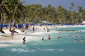
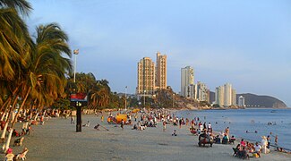
Colombia is located in the North West area of the South American continent. Colombia coasts are along the Caribbean Sea and Pacific Ocean. The Andes Mountains are within the borders of Colombia, and are a popular destination for tourists to hike.[citation needed]
Along the coast and in the northern areas of the country the climate is "warm and tropical ... with a rainy season from May to November."[11] The temperature stays fairly consistent throughout the year because Colombia is so close to the equator. The variety in temperature comes from the level of altitude; it is much cooler in the higher altitudes of Colombia than the low land coastal areas.[citation needed]
Holidays
Popular times to visit Colombia include the most famous festivals such as the
Music
Colombia is known as "the land of a thousand rhythms". Colombia has more than 1,025 folk rhythms.
Some of the main genres are:
- Chandé (from Colombian Atlantic Coast). It is a cheerful and partying rhythm that is part of the coastal idiosyncrasies and carnivals. It comes from the fusion of indigenous rhythms with African black music
- Alabaos (Funeral dirge in dialogue, Afro-Colombian culture)
- Bambuco (from Colombian Andean region, European rithm)
- Bullerengue (from Caribbean Region, Afro-Colombian music)
- Bunde chocoano (from Chocó Region, Afro-Colombians learned from the Native Americans when as black slaves during colonial escaped and took refuge in remote areas and were received with hospitality by Native Americans of the Pacific coast)
- Bunde tolimense (Euro-Colombian music)
- Cumbia (most representative from the Atlantic Coast, indigenous and African rhythm, of great expressive richness, it has variations by region)
- Currulao(from Pacific Region, Afro-Colombian culture)
- Danza Colombia (from Colombian Andes, from European origin with Indigenous elements)
- Guabina (from Andes Region, Indigenous rithm)
- Joropo (from Los Llanos Venezuelan-Colombian Region, its lyrics are messages that express the values of the llaneran people, European origin music genre)
- Mapalé (from Atlantic coast, Afro-Colombian rithm)
- Merecumbé (mix between Colombian merengue and cumbia of Atlantic coast, created by Pacho Galán in 1950´s)
- Colombian Pasillo (European origin)
- Carranga The carranga, carranguera music or peasant music, is a genre of folk music originated in the Colombian Andean region, more exactly in the department of Boyacá in the years 70, of the hand of the composer Jorge Velosa and the Carrangueros de Ráquira .In the execution of the carranguera music the guitar, the tiple, requinto-tiple, the guacharaca and the voice are used.
- Porro
- Sanjuanero (bambuco and joropo fussion)
- Champeta (The classical conception of champetuísmo has four important aspects: musical expression, its distinctive jargon, the "picós" and perreos -fiestas and verbenas-. Some give the same importance to other aspects, such as dancing, political activism, designing clothing, audiovisual aspect of its videos, and other cultural elements, of Afro-Colombian music)
- Torbellino(representative songs of the departments of Boyacá, Cundinamarca and Santander, It tune of religious and family fiestas)
- Vallenato (from Atlantic Coast Region, it is important to the narrative nature of love's stories or descriptions of people, it was declared Intangible Cultural Heritage of the Nation).
Visitors
Most visitors arriving to Colombia on short-term basis in are from the following countries of nationality:[15]
| Rank | Country | 2016 | 2017 |
|---|---|---|---|
| 1 | Venezuela | 352,392 | 767.347 |
| 2 | United States | 498,960 | 529.013 |
| 3 | Brazil | 181,852 | 209.138 |
| 4 | Argentina | 135,151 | 185.891 |
| 5 | Mexico | 158,975 | 171.841 |
| 6 | Ecuador | 167,121 | 168.998 |
| 7 | Peru | 140,055 | 140.905 |
| 8 | Chile | 127,271 | 138.647 |
| 9 | Spain | 104,623 | 112.637 |
| 10 | Panama | 103,014 | 110.629 |
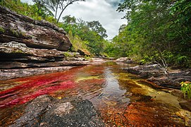
Ecotourism
The great variety in geography, flora and fauna across Colombia has also resulted in the development of an
National parks
.svg)
Colombia has two coastlines; Pacific and Caribbean, three main mountainous chains and the isolated Sierra Nevada de Santa Marta, and many different ecological regions, from páramo to tropical jungle vegetation to desert biomes. The country hosts numerous volcanoes and waterfalls.
- Amacayacu National Park
- Cabo de la Vela
- Chiribiquete National Park
- Cocora valley
- Los Nevados
- Doña Juana-Cascabel Volcanic Complex
- Gorgona and Malpeloislands
- Los Katíos National Park
- Munchique National Park
- Serranía de la Macarena
- Sierra Nevada de Santa Marta National Park
- PANACA Park
- Tayrona Park (Santa Marta)
- Tatacoa Desert
- Chicamocha Canyon National Park
- El Mariposario entomologic display specialized in Lepidoptera
- Peñas Blancas rock climbingsite
Safety
For many years serious internal
Travel guide Lonely Planet ranked Colombia second in its list of best countries to visit in 2017. Colombia has been celebrated for its forward-thinking vibrant culture and hospitality.[17]
Transportation
Railways
The nation's rail network links seven of the country's 10 major cities. During 2004–6, approximately 2,000 kilometers of the country's rail lines underwent refurbishment. This upgrade involved two main projects: the 1,484-kilometer line linking Bogotá to the Caribbean Coast and the 499-kilometer Pacific coastal network that links the industrial city of
Roads
Highways are managed by the
Ports, waterways, and merchant marine
A well-developed and important form of transport for both cargo and passengers, inland waterways transport approximately 3.8 million metric tons of freight and more than 5.5 million passengers annually. Main inland waterways are the Magdalena–Cauca River system, which is navigable for 1,500 kilometers; the Atrato, which is navigable for 687 kilometers; the Orinoco system of more than five navigable rivers, which total more than 4,000 kilometers of potential navigation (mainly through Venezuela); and the Amazonas system, which has four main rivers totaling 3,000 navigable kilometers (mainly through Brazil). The government is planning an ambitious program to more fully utilize the main rivers for transport.[18]
Aviation

All public airports in Colombia are managed and controlled by the
Colombia has well-developed air routes and an estimated total of 984 airports, 100 of which have paved runways, plus two heliports. Of the 74 main airports, 20 can accommodate jet aircraft. Two airports are more than 3,047 meters in length, nine are 2,438–3,047 meters, 39 are 1,524–2,437 meters, 38 are 914–1,523 meters, 12 are shorter than 914 meters, and 880 have unpaved runways. The government has been selling its stake in local airports in order to allow their privatization. The country has 40 regional airports, and the cities of Bogotá, Medellín, Cali, Barranquilla, Bucaramanga, Cartagena, Cúcuta, Leticia, Pereira, San Andrés, and Santa Marta have international airports. Bogotá's El Dorado International Airport handles 550 million metric tons of cargo and 22 million passengers a year, making it the largest airport in Latin America in terms of cargo and the third largest in passenger numbers.[18]
Urban transport
.JPG)
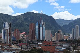
Urban transport systems have been developed in Bogotá, Medellín, Cali and Barranquilla. Traffic congestion in Bogotá has been greatly exacerbated by the lack of rail transport. However, this problem has been alleviated somewhat by the development of one of the world's largest and highest capacity
World Heritage Sites
As of 2018, there are nine World Heritage Sites in Colombia, including six cultural sites, two natural sites and one mixed site.
| Site | Image | Location | Criteria | Area ha (acre) |
Year | Description |
|---|---|---|---|---|---|---|
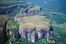
| Chiribiquete National Park– "The Maloca of the Jaguar" | 
|
Caquetá and Guaviare Departments, 0°31′31″N 72°47′50″W / 0.52528°N 72.79722°W |
Mixed: (iii), (ix), (x) |
2,782,354 (6,875,350); buffer zone 3,989,682.82 (9,858,721.0) | 2018 | Located in the north-west Colombian Amazon, Chiribiquete National Park is the largest protected area in the country. One of the defining features of the park is the presence of tepuis (the Native American word for table-top mountains), sheer-sided sandstone plateaux that dominate the forest. Over 75,000 paintings, spanning more than 20,000 years to the present, are to be seen on the walls of the 60 rock shelters around the bases of the tepuis. Believed to be linked to the worship of the jaguar, a symbol of power and fertility, these paintings depict hunting scenes, battles, dances and ceremonies. The indigenous communities, which are not directly present on the site, consider the region sacred.[20] |
| Coffee Cultural Landscape of Colombia | 
|
Caldas, Quindío and Risaralda Departments 5°28′18″N 75°40′54″W / 5.47167°N 75.68167°W |
Cultural: (v)(vi) |
141,120 (348,700) | 2011 | Encompasses six farming landscapes that use the "centennial tradition of coffee growing in small plots in the high forest and the way farmers have adapted cultivation to difficult mountain conditions."[21] |
| Historic Centre of Santa Cruz de Mompox | 
|
Bolívar Department 9°14′00″N 74°26′00″W / 9.23333°N 74.43333°W |
Cultural: (iv)(v) |
0 | 1995 | It was a town center in the Colonial period and the colonial architecture has been preserved.[22] |
| Los Katíos National Park | .jpg)
|
Antioquia and Chocó Departments 7°40′00″N 77°00′00″W / 7.66667°N 77.00000°W |
Natural: (ix)(x) |
141,120 (348,700) | 1994 | Forests and low hills that is the habitat for many endangered animals and plants.[23] |
| Malpelo Fauna and Flora Sanctuary | 
|
Valle del Cauca Department 3°58′00″N 81°37′00″W / 3.96667°N 81.61667°W |
Natural: (vii)(ix) |
857,500 (2,119,000) | 2006 | A designated non-fishing area that provides a rich habitat for sharks, giant grouper and billfish and the rare, short-nosed ragged-toothed shark.[24] |
| National Archeological Park of Tierradentro | 
|
Cauca Department 2°35′00″N 76°02′00″W / 2.58333°N 76.03333°W |
Cultural: (iii) |
0 | 1995 | National archeological park with several human figure statues, and large tombs.[25] |
| Port, Fortresses and Group of Monuments, Cartagena | 
|
Bolívar Department 10°25′00″N 75°32′00″W / 10.41667°N 75.53333°W |
Cultural: (iii) |
0 | 1984 | The most extensive fortifications in South America.[26] |
| Qhapaq Ñan, Andean Road System | Nariño Department, shared with 18°15′00″S 69°35′30″W / 18.25000°S 69.59167°W |
Cultural: (ii)(iii)(iv)(vi) |
11,407 (28,190) | 2014 | Most advanced pre-Columbian transportation system. "This site is an extensive Inca communication, trade and defense network of roads covering 30,000 km"[27] | |
| San Agustín Archaeological Park | 
|
Huila Department 1°55′00″N 76°14′00″W / 1.91667°N 76.23333°W |
Cultural: (iii) |
0 | 1995 | Pre-Columbian, carved volcanic stone figures and tombs in the Forest of Statues, native trees and flowers. Lavapatas Spring's rock bed and ceremonial water channels and reptilian shapes.[28][29] |
Notable celebrations
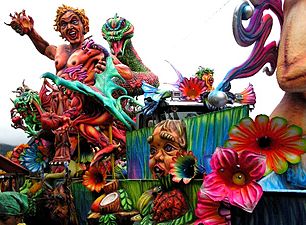
- Barranquilla's Carnival[30]
- Blacks and Whites' Carnival[31]
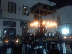
- Holy Week in Popayán[32]
-
-
 Barranquilla's Carnival
 -


Gallery
-
-

-

-
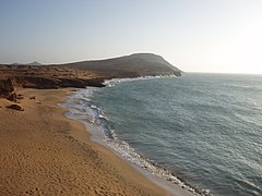 La Guajira
 -

-
 Magdalena
 -

-

-
 San Andrés y Providencia
 -
 Boyacá
 -

-

-

-
 Caldas
 -

-
-

-
-

-

-
 Las Lajas Sanctuary
Nariño -
 Gorgona Island
Cauca -
-

-

-
-
-
-


.JPG)


.jpg)


See also
- Pueblos Patrimonio
- Seven Wonders of Colombia
- Visa policy of Colombia
- Jaime Duque Park
- List of World Heritage Sites in Colombia
References
- ^ "The Travel & Tourism Competitiveness Report 2017" (PDF). World Economic Forum. p. 130.
- ^ ISBN 9789284419029.
- ^ "La OMT destaca crecimiento del turismo en Colombia en los últimos diez años" (in Spanish). lainformacion.com. 25 June 2014. Archived from the original on 11 July 2014.
- ^ a b "Hacia el turismo científico en Colombia". todoesciencia.gov.co.
- ^ a b "Responsible tourism". sustainabletourism.net.
- ^ a b c Roberto Steiner and Hernán Vallejo. "Tourism". In Colombia: A Country Study (Rex A. Hudson, ed.). Library of Congress Federal Research Division (2010).
 This article incorporates text from this source, which is in the public domain.
- ^ "Vasco Núñez de Balboa" (in Spanish). biografiasyvidas.com. Retrieved 2 April 2014.
- ^ Rodriguez Gómez, Juan Camilo. "La independencia del Socorro en la génesis de la emancipación colombiana" (in Spanish). banrepcultural.org.
- ^ Restrepo, Eduardo (2006). "Abolitionist arguments in Colombia" (in Spanish). História Unisinos. pp. 293–306.
- ^ Beluche, Olmedo (2003). "The true history of the separation of 1903 – La verdadera historia de la separación de 1903" (PDF) (in Spanish). ARTICSA. Archived from the original (PDF) on 30 October 2015.
- ^ "Colombia – World Travel Guide". World Travel Guide. Retrieved 27 February 2018.
- ^ "gosouthamerica.com Holy week in Colombia and Venezuela". Gosouthamerica.about.com. 18 August 2011. Retrieved 18 October 2011.
- ^ "Holy week in Colombia". Colombia.com. Retrieved 18 October 2011.
- ^ "Colombia's Mind-Blowing Music Festivals: The 2019 Guide | ViaHero". www.viahero.com. Retrieved 28 January 2019.
- ^ Informes de turismo
- ^ "La OMT destaca crecimiento del turismo en Colombia en los últimos diez años" (in Spanish). lainformacion.com. 25 June 2014. Archived from the original on 11 July 2014.
- ^ "Top Countries. Ten destinations you cannot afford to miss". Lonely Planet.
- ^ a b c d Colombia country profile. Library of Congress Federal Research Division (February 2007). This article incorporates text from this source, which is in the public domain.
- ^ "Global BRT Data". Retrieved 22 August 2014.
- ^ "Chiribiquete National Park – "The Maloca of the Jaguar"". UNESCO. Retrieved 1 July 2018.
- ^ "Coffee Cultural Landscape of Colombia". UNESCO. Retrieved 8 August 2016.
- ^ "Historic Centre of Santa Cruz de Mompox". UNESCO. Retrieved 8 August 2016.
- ^ "Los Katíos National Park". UNESCO. Retrieved 8 August 2016.
- ^ "Malpelo Fauna and Flora Sanctuary". UNESCO. Retrieved 8 August 2016.
- ^ "National Archeological Park of Tierradentro". UNESCO. Retrieved 8 August 2016.
- ^ "Port, Fortresses and Group of Monuments, Cartagena". UNESCO. Retrieved 8 August 2016.
- ^ "Qhapaq Ñan, Andean Road System". UNESCO. Retrieved 8 August 2016.
- ^ "San Agustín Archaeological Park". UNESCO. Retrieved 8 August 2016.
- ^ Centre, UNESCO World Heritage. "San Agustín Archaeological Park". whc.unesco.org. Retrieved 28 March 2018.
- ^ "Carnival of Barranquilla". UNESCO. Retrieved 9 December 2015.
- ^ "Carnaval de Negros y Blancos". UNESCO. Retrieved 9 December 2015.
- ^ "Holy Week processions in Popayán". UNESCO. Retrieved 9 December 2015.
Bibliography
- Lipski, John M. (1994), Latin American Spanish, Longman, ISBN 978-0-582-08761-3
External links
 Colombia travel guide from Wikivoyage