
Toyota, Aichi
This article has multiple issues. Please help improve it or discuss these issues on the talk page. (Learn how and when to remove these template messages)
|
Toyota
豊田市 | |
|---|---|
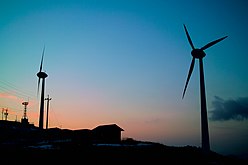
Asuke Town Kuragaike Park Sanage-jinja Shrine Toyota skyline | |
|
Sunflower | |
| Tree | Zelkova serrata |


Toyota (豊田市, Toyota-shi, pronounced [toꜜjota ɕi]), formerly known as Koromo, is a city in Aichi Prefecture, Japan. As of 1 October 2019[update], the city had an estimated population of 426,162 and a population density of 464 people per km2. The total area was 918.32 square kilometres (354.57 sq mi). It is located about 50 minutes from Nagoya by way of the Meitetsu Toyota Line.
Several of Toyota Motor Corporation's manufacturing plants, including the Tsutsumi plant, are located here. The longstanding ties between the Toyota Motor Corporation and the town of Toyota, formerly known as Koromo (挙母市, Koromo-shi), gave the town its current name. The city's flag (and seal), is a unicursal hexagram.
Geography
Toyota is located in north-central Aichi Prefecture, and is the largest city in the prefecture in terms of area. The city area is mountainous to the north, with peaks averaging around 1000 feet (328 m) in height along its northern border with Nagano and Gifu Prefectures. Much of the mountainous northern portion of the city is within the Aichi Kōgen Quasi-National Park.
Toyota is within a two-hour drive of Nagoya.[1]
-
 Downtown
 -
 Iyama
Iyama -
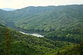
 Kuroda Lake
 -
 Mikawa Lake
 -
 Okuyahagi Lake


.jpg)


Climate
The city has a climate characterized by hot and humid summers, and relatively mild winters (Köppen climate classification, Cfa). The average annual temperature in Toyota is 15.3 °C (59.5 °F). The average annual rainfall is 1,470.4 mm (57.89 in) with September as the wettest month. The temperatures are highest on average in August, at around 27.4 °C (81.3 °F), and lowest in January, at around 3.6 °C (38.5 °F).[2]
| Climate data for Toyota (1991−2020 normals, extremes 1979−present) | |||||||||||||
|---|---|---|---|---|---|---|---|---|---|---|---|---|---|
| Month | Jan | Feb | Mar | Apr | May | Jun | Jul | Aug | Sep | Oct | Nov | Dec | Year |
| Record high °C (°F) | 17.8 (64.0) |
22.2 (72.0) |
24.9 (76.8) |
30.5 (86.9) |
34.4 (93.9) |
36.2 (97.2) |
39.7 (103.5) |
39.6 (103.3) |
38.1 (100.6) |
32.2 (90.0) |
25.6 (78.1) |
22.6 (72.7) |
39.7 (103.5) |
| Mean daily maximum °C (°F) | 9.1 (48.4) |
10.3 (50.5) |
14.2 (57.6) |
19.9 (67.8) |
24.7 (76.5) |
27.7 (81.9) |
31.5 (88.7) |
33.3 (91.9) |
29.2 (84.6) |
23.3 (73.9) |
17.4 (63.3) |
11.6 (52.9) |
21.0 (69.8) |
| Daily mean °C (°F) | 3.6 (38.5) |
4.5 (40.1) |
8.3 (46.9) |
13.7 (56.7) |
18.5 (65.3) |
22.3 (72.1) |
26.3 (79.3) |
27.4 (81.3) |
23.7 (74.7) |
17.6 (63.7) |
11.4 (52.5) |
5.9 (42.6) |
15.3 (59.5) |
| Mean daily minimum °C (°F) | −1.3 (29.7) |
−0.8 (30.6) |
2.4 (36.3) |
7.5 (45.5) |
12.7 (54.9) |
17.8 (64.0) |
22.1 (71.8) |
23.0 (73.4) |
19.3 (66.7) |
12.9 (55.2) |
6.3 (43.3) |
1.0 (33.8) |
10.2 (50.4) |
| Record low °C (°F) | −8.6 (16.5) |
−8.8 (16.2) |
−5.6 (21.9) |
−2.6 (27.3) |
0.8 (33.4) |
8.2 (46.8) |
14.7 (58.5) |
14.1 (57.4) |
6.5 (43.7) |
1.1 (34.0) |
−2.5 (27.5) |
−7.6 (18.3) |
−8.8 (16.2) |
| Average precipitation mm (inches) | 48.0 (1.89) |
61.2 (2.41) |
112.0 (4.41) |
119.5 (4.70) |
142.2 (5.60) |
183.6 (7.23) |
195.3 (7.69) |
125.8 (4.95) |
201.8 (7.94) |
152.8 (6.02) |
75.9 (2.99) |
52.6 (2.07) |
1,470.4 (57.89) |
| Average precipitation days (≥ 1.0 mm) | 5.7 | 6.7 | 9.1 | 9.6 | 9.6 | 11.6 | 12.1 | 8.6 | 11.0 | 9.7 | 6.6 | 6.6 | 106.9 |
| Mean monthly sunshine hours | 171.6 | 175.0 | 198.7 | 203.0 | 202.6 | 148.5 | 172.1 | 209.6 | 161.6 | 168.6 | 166.2 | 165.9 | 2,143.3 |
| Source: Japan Meteorological Agency[3][2] | |||||||||||||
| Climate data for Inabu, Toyota (1991−2020 normals, extremes 1979−present) | |||||||||||||
|---|---|---|---|---|---|---|---|---|---|---|---|---|---|
| Month | Jan | Feb | Mar | Apr | May | Jun | Jul | Aug | Sep | Oct | Nov | Dec | Year |
| Record high °C (°F) | 15.3 (59.5) |
18.1 (64.6) |
23.0 (73.4) |
27.4 (81.3) |
30.4 (86.7) |
32.4 (90.3) |
35.5 (95.9) |
35.0 (95.0) |
33.6 (92.5) |
29.4 (84.9) |
22.7 (72.9) |
19.7 (67.5) |
35.5 (95.9) |
| Mean daily maximum °C (°F) | 5.4 (41.7) |
6.9 (44.4) |
11.1 (52.0) |
16.9 (62.4) |
21.5 (70.7) |
24.4 (75.9) |
28.0 (82.4) |
29.4 (84.9) |
25.8 (78.4) |
20.2 (68.4) |
14.3 (57.7) |
8.2 (46.8) |
17.7 (63.8) |
| Daily mean °C (°F) | 0.2 (32.4) |
1.0 (33.8) |
4.8 (40.6) |
10.2 (50.4) |
15.2 (59.4) |
19.1 (66.4) |
22.9 (73.2) |
23.7 (74.7) |
20.1 (68.2) |
14.1 (57.4) |
7.8 (46.0) |
2.5 (36.5) |
11.8 (53.3) |
| Mean daily minimum °C (°F) | −4.1 (24.6) |
−3.9 (25.0) |
−0.7 (30.7) |
3.9 (39.0) |
9.3 (48.7) |
14.7 (58.5) |
18.9 (66.0) |
19.6 (67.3) |
16.1 (61.0) |
9.5 (49.1) |
2.8 (37.0) |
−1.9 (28.6) |
7.0 (44.6) |
| Record low °C (°F) | −13.9 (7.0) |
−16.1 (3.0) |
−11.2 (11.8) |
−5.7 (21.7) |
−0.9 (30.4) |
4.3 (39.7) |
11.3 (52.3) |
9.6 (49.3) |
3.8 (38.8) |
−1.8 (28.8) |
−6.5 (20.3) |
−12.0 (10.4) |
−16.1 (3.0) |
| Average precipitation mm (inches) | 69.7 (2.74) |
85.8 (3.38) |
160.6 (6.32) |
157.8 (6.21) |
169.4 (6.67) |
223.8 (8.81) |
281.8 (11.09) |
214.4 (8.44) |
296.3 (11.67) |
190.5 (7.50) |
99.4 (3.91) |
76.8 (3.02) |
2,026.2 (79.77) |
| Average precipitation days (≥ 1.0 mm) | 8.0 | 8.2 | 10.8 | 11.2 | 10.9 | 13.5 | 14.7 | 12.0 | 12.3 | 10.6 | 8.0 | 8.4 | 128.6 |
| Mean monthly sunshine hours | 143.9 | 157.3 | 183.6 | 195.2 | 193.4 | 136.3 | 154.3 | 187.4 | 149.4 | 156.3 | 153.1 | 139.4 | 1,949.7 |
| Source: Japan Meteorological Agency[4][5] | |||||||||||||
Demographics

Per Japanese census data,[6] the population of Toyota has been increasing over the past 50 years.
| Year | Pop. | ±% |
|---|---|---|
| 1960 | 151,632 | — |
| 1970 | 234,078 | +54.4% |
| 1980 | 315,871 | +34.9% |
| 1990 | 370,858 | +17.4% |
| 2000 | 395,224 | +6.6% |
| 2010 | 421,552 | +6.7% |
Surrounding municipalities
City scape
-
 Skyline of Toyota
 -

-
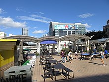 Toyotashi Station Pedestrian Deck
 -
 Downtown of Toyota


History
This section needs additional citations for verification. (April 2017) |
Origins
The area of present-day Toyota City has been inhabited since prehistoric times, and archaeologists have found a continuous record of artifacts from the
Edo period
During the
Meiji period
After the
The area was a major producer of
Modern history
On March 1, 1951, Koromo gained city status, and absorbed the village of Takahashi from Nishikamo District on September 30, 1956. Due to the fame and economic importance of its major employer, the city of Koromo (挙母市) changed its name to Toyota on January 1, 1959.
Toyota became a sister city with
In 1979 the
Toyota became a Core City in 1998, with increased local autonomy.
On March 25, 2005,
On April 1, 2005, Toyota absorbed the town of
Mitsuru Obe and Eric Pfanner of
-
 Sanage shinto shrine
 -
 Asuke area (Groups of Traditional Buildings)
 -
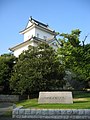 Koromo Castle
 -
 City center of Toyota


.jpg)
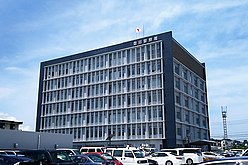
Government

Mayor-council
Toyota has a
Prefectural Assembly
The city contributes five members to the Aichi Prefectural Assembly.
House of Representatives
In terms of national politics, the city is divided between Aichi District 11 and Aichi District 14 of the
Public
Police
- Aichi Prefectural Police
- Asuke police station
- Toyota police station
Firefighting
- Fire department
- Toyota-Kita fire department
- Toyota-Minami fire department
- Toyota-naka fire department
- Asuke fire department
Health care
- Hospital
- Asuke Hospital
- Toyota Kosei Hospital
- TOYOTA Memorial Hospital
Post office
- Toyota Post office
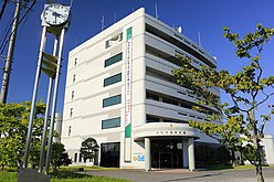
Library
- Toyota City Library
-
 Toyota Police Station
 -
 Toyota Fire Department
 -
 Toyota Kosei Hospital
 -
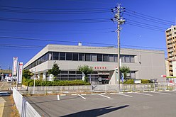 Toyota Post Office
 -
 Toyota City Library


.jpg)
Twin towns – sister cities
 Detroit, United States (since 1960)
 Derbyshire, England, United Kingdom (since 1998)
Economy

Primary sector of the economy
- Agriculture
- Peach
- Pyrus pyrifolia (Atago)
- Forestry
Secondary sector of the economy
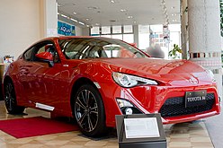
The main headquarters of Toyota is located in a 14-story building in Toyota. As of 2006 the head office has the "Toyopet" Toyota logo and the words "Toyota Motor". The Toyota Technical Center, a 14-story building, and the original Honsha plant, Toyota's first plant engaging in mass production and formerly named the Koromo plant, are adjacent to one another in a location near the headquarters. Vinod Jacob from The Hindu described the main headquarters building as "modest".[1] In 2013 company head Akio Toyoda reported that it had difficulties retaining foreign employees at the headquarters due to the lack of amenities in Toyota.[13]
Tertiary sector of the economy
- Shopping center
- Æon Toyota
- Æon Takahashi(GREEN CITY)
- KiTARA
- Lut's
- Meglia
- T-FACE
-
 Azakai Town
 -
 Inabu Town
 -

-
-
 Æon Toyota
 -
 KiTARA

.jpg)


Education
.jpg)
Colleges and universities
- Aichi Gakusen University
- Aichi Institute of Technology
- Toyota National College of Technology
- Aichi Mizuho College
- Ohkagakuen University – Toyota campus
- Chukyo University – Toyota campus
- Japanese Red Cross Toyota College of Nursing
- Junior College of Toyota (1990–1999)
Primary and secondary education
Toyota has 78 public elementary schools and 27 public middle schools operated by the city government and 12 public high schools operated by the Aichi Prefectural Board of Education. There are also two private middle schools and eight private high schools. The prefecture also operates two special education schools for the disabled.
International schools
- Escola Alegria de Saber – Brazilian school[14]
- Escola NECTAR – Brazilian primary school[14]
- Escola Pintando o Sete – Brazilian primary school[14]
Transportation
Toyota, as the home city of
Railways
Conventional lines
- Kamitoyota – Jōsui
- Aichi Loop Line: Mikawa-Kamigō – Ekaku – Suenohara – Mikawa-Toyota – Shin-Uwagoromo – Shin-Toyota – Aikan-Umetsubo – Shigō – Kaizu – Homi – Sasabara – Yakusa
Roads
Expressways
Japan National Route
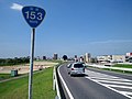
 National Route 153
 National Route 155
 National Route 248
 National Route 301
 National Route 419
 National Route 420
 National Route 257
 National Route 473
-
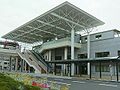
 Toyotashi Station
 -
 Shin-Toyota Station
 -
 Toyota JCT
 -
 Toyota-Higashi JCT
 -
-
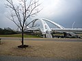 Toyota big bridge
 -
 Toyota Arrows Bridge


Local attractions
- Asuke area (Groups of Traditional Buildings)
- Toyota Municipal Museum of Art
- Toyota Automobile Museum
- Toyota Kaikan Exhibition Hall
- Toyota Kuragaike Commemorative Hall
- Kampachi Gorge
- Kōrankei Gorge
- Kuragaike park
- Obara shikizakura
- The ruins of Matsudaira
-
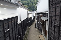 Asuke area
 -
 Asuke Castle
 -

-
 Toyota Kaikan Exhibition Hall
 -
 Toyota Kuragaike Commemorative Hall
 -
 Kampachi Gorge
 -
 Kōrankei Gorge
 -
 Sanshu Asuke Yashiki
 -
 Kōjaku-ji
 -
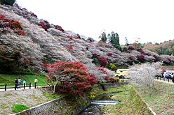 Obara shikizakura
 -
 The ruins of Matsudaira
 -
 Kuragaike park
 -
 Koromo Festival


Culture
Sports
Sports Team
| Sex | Name | competition | League | Home | Sponsor | Since |
|---|---|---|---|---|---|---|
| Men | Toyota Verblitz | Rugby | Japan Rugby League One | Toyota Sports Center
|
Toyota Motor Corporation
|
1941 |
| Men | Toyota Sunhawks | Volleyball | V.League (V2) | Toyota Sports Center
|
Toyota Motor Corporation
|
1946 |
| Men | Toyota Baseball club | Baseball | Japan Amateur Baseball Association (JABA) | Toyota Sports Center
|
Toyota Motor Corporation
|
1947 |
| Women | Toyota Red Terriers | Softball | Japan Softball League (JSL) | Toyota Sports Center
|
Toyota Motor Corporation
|
1948 |
| Women | Toyota Sunpiena | Volleyball | V.League (V2) | Toyota Sports Center
|
Toyota Motor Corporation
|
1950 |
| Men | Toyota Griffins | Handball | Japan Handball League (JHL・Challenge Division) | Toyota Sports Center
|
Toyota Motor Corporation
|
1970 |
| Men | Kirix Toyota Bull Fighters | American football | X-League | Toyota Athletic Stadium | Kirix Group | 1974 |
| Men | Toyota Tsusho BLUE WING | Rugby | TOP West League | Fujioka Ground | Toyota Tsusho | 1980 |
| Men | Nagoya Grampus | Soccer
|
J.League (J1) | Toyota Stadium | Nagoya Grampus Eight Inc. | 1991 |
Sports Facilities
- Sky Hall Toyota
- Toyota Athletic Stadium
- Toyota Sports Center
- Toyota Stadium
Notable people from Toyota
- Suzuki Shōsan, Edo period Zen prelate
- Yoshio Markino, artist, author
- Miliyah Kato, singer
- Masami Mitsuoka, singer
- Etsuko Nishio, singer, actress
- Katsuaki Watanabe, former president of Toyota Motors
- Tadashi Sugiura, professional baseball player
- Masato Naito, Olympic hurdler
References
- ^ a b Jacob, Vinod. "In Toyota land Archived 2010-07-21 at the Wayback Machine." The Hindu Business Line. August 18, 2006. Retrieved on May 9, 2013.
- ^ a b 気象庁 / 平年値(年・月ごとの値). JMA. Retrieved April 13, 2022.
- ^ 観測史上1~10位の値(年間を通じての値). JMA. Retrieved April 13, 2022.
- ^ 観測史上1~10位の値(年間を通じての値). JMA. Retrieved April 13, 2022.
- ^ 気象庁 / 平年値(年・月ごとの値). JMA. Retrieved April 13, 2022.
- ^ Toyota population statistics
- ^ "Municipalities of Aichi (Japan)". Archived from the original on 21 October 2012. Retrieved 22 May 2011.
- ^ "Toyota Honsha Plant history". Archived from the original on 2015-03-06. Retrieved 2015-06-27.
- ^ 豊田市. "山村地域移住情報バンク|豊田市". Toyota City (in Japanese). Retrieved 2024-02-07.
平成17年4月1日に旧藤岡町、小原村、足助町、下山村、旭町、稲武町(旧6町村)が合併し、現在の豊田市になりました。
- ^ "愛知県の市町村合併 - 愛知県". Aichi Prefectural Government. Retrieved 2024-02-07.
- ^ Obe, Mitsuru and Eric Pfanner. "Abe’s Backing Is Lukewarm, Even in Toyota’s Town". The Wall Street Journal. December 11, 2014. Retrieved on August 12, 2015.
- ^ "国際交流". city.toyota.aichi.jp (in Japanese). Toyota. Retrieved 2023-12-27.
- ^ Greimel, Hans. "Dreary HQ city is a handicap in global glitz plan." (Archive) Automotive News. May 6, 2013. Retrieved on May 9, 2013.
- ^ a b c "Escolas Brasileiras Homologadas no Japão" (Archive). Embassy of Brazil in Tokyo. Retrieved on October 13, 2015.
External links
- Official website (in Japanese)
| Nagoya |
| |||
|---|---|---|---|---|
| Core cities | ||||
| Special city | ||||
| Cities | ||||
| Districts | ||||
| Former Districts | ||||
| 2,000,000 and more | |
|---|---|
| 1,000,000–1,999,999 | |
| 500,000–999,999 | |
| 200,000–499,999 |
|
| International | |
|---|---|
| National | |
| Geographic | |