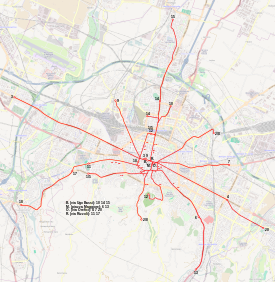
Trams in Bologna
| Trams in Bologna (1880–1963) | |||
|---|---|---|---|
 | |||
| Overview | |||
| Locale | Bologna, Italy | ||
| Transit type | Tram | ||
| Number of lines | 16 (maximum) | ||
| Operation | |||
| Began operation | 2 October 1880 | ||
| Ended operation | 3 November 1963 | ||
| Technical | |||
| Track gauge | 1445 mm | ||
| Electrification | 550 V DC (since 1904) | ||
| |||
The Bologna tramway network (Italian: Rete tranviaria di Bologna) was an important part of the public transport network of Bologna, Italy. It was established in 1880 and discontinued in 1963.[1]
History
The first plans for six horsecar lines were approved by the town council in 1877:[2]
- Piazza Vittorio Emanuele-Bologna Centrale railway station
- Piazza Vittorio Emanuele-Porta San Felice
- Piazza Vittorio Emanuele-Barriera Santo Stefano
- Piazza Vittorio Emanuele-Porta Maggiore
- Piazza Vittorio Emanuele-Porta San Mamolo
- Piazza Vittorio Emanuele-Porta Saragozza.
Works on the first stretch, linking Bologna Centrale railway station to Piazza Maggiore, began in September 1880. Service began on Saturday, 2 October 1904.[2]
The first two electrified lines began operating on 11 February 1904.[2]
In 1953, it was decided that, starting from the following year, tramway lines would be gradually discontinued and transformed to bus and trolleybus lines. Service was officially discontinued on Sunday, 3 November 1963, when the last tramway service operated on the last remaining line to San Ruffillo.[2][1]
Routes
1902 to 1910 Network
- Piazza Vittorio Emanuele-Via Indipendenza-Bologna Centrale railway Station
- Piazza Vittorio Emanuele-Piazza del Nettuno-Via Ugo Bassi-Via San Felice-Porta San Felice
- Piazza Vittorio Emanuele-Via dell'Archiginnasio-Piazza Galvani-Via Farini-Via Santo Stefano-Località Lo Sterlino
- Piazza Vittorio Emanuele-Via d'Azeglio-Palazzina
- Piazza Vittorio Emanuele-Porta Saragozza
- Piazza Vittorio Emanuele-Porta Zamboni-Sobborgo Sant'Egidio
- Piazza Vittorio Emanuele-Porta San Vitale
- Piazza Vittorio Emanuele-Porta Lame
- Porta San Felice-Scala
- Porta Galliera-Stabilimento Tramways della Zucca
1910 to 1932 Network
- 1 Piazza Vittorio Emanuele-Bologna Centrale railway Station
- 2 Piazza Vittorio Emanuele-Via D'Azeglio
- 3 Piazza Vittorio Emanuele-Via Saffi-Scala
- 4 Piazza Vittorio Emanuele-Mazzini
- 5 Piazza Vittorio Emanuele-Saragozza
- 6 Piazza Vittorio Emanuele-Santo Stefano
- 7 Piazza Vittorio Emanuele-San Vitale
- 8 Piazza Vittorio Emanuele-Zamboni
- 9 Piazza Vittorio Emanuele-Lame
- 10 Piazza Vittorio Emanuele-Zucca
- 11 Piazza Vittorio Emanuele-Sant'Isaia
- 12 Piazza Vittorio Emanuele-Castiglione
1932 Network
- 1 Piazza Vittorio Emanuele-Bologna Centrale railway Station
- 2 Piazza Vittorio Emanuele-Via D'Azeglio
- 3 Piazza Vittorio Emanuele-Via Saffi-Scala
- 4 Piazza Vittorio Emanuele-Mazzini
- 5 Piazza Vittorio Emanuele-Saragozza
- 6 Piazza Vittorio Emanuele-Santo Stefano-Sterlino-San Ruffillo
- 7 Piazza Vittorio Emanuele-San Vitale
- 8 Piazza Vittorio Emanuele-Zamboni
- 9 Piazza Vittorio Emanuele-Lame-
- 10 Piazza Vittorio Emanuele-Zucca-Casaralta
- 11 Piazza Vittorio Emanuele-Sant'Isaia-Littoriale
- 12 Piazza Vittorio Emanuele-Castiglione-San Michele in Bosco
- 15 Piazza Vittorio Emanuele-Corticella
- 16 Piazza Vittorio Emanuele-Mascarella
Network as of 1943
- 1 Bologna Centrale railway Station
- 2 Bologna Centrale Railway Station-Piazza Vittorio Emanuele-Via d'Azeglio
- 3 Via Montegrappa-Via Saffi-Scala
- 4 Piazza Re Enzo-Via Mazzini
- 5 Via Venezian-Porta Saragozza
- 6 Piazza Vittorio Emanuele-Chiesanuova
- 7 Via Venezian-Porta San Vitale
- 9 Via Montegrappa-Porta Lame
- 10 Piazza Galvani-Piazza Vittorio Emanuele-Zucca-Casaralta
- 11 Piazza Cavour-Porta Sant'Isaia-Littoriale
- 13 Piazza Minghetti-Chiesanuova-San Ruffillo
- 14 Piazza Galvani-Piazza Vittorio Emanuele-Ippodromo/Mercato Ortofrutticolo
- 15 Piazza De Marchi-Corticella
- 17/20 Funivia di San Luca-Bologna Centrale railway Station
- 18 Piazza Malpighi-Littoriale-Casalecchio di Reno
- 19 Piazza Malpighi-Littoriale-Casalecchio di Reno - Connected with Casalecchio-Vignola Railway
Network as of 1952
The post-
- 1/5 Porta Saragozza
- 2/8 Via D'Azeglio-Via Zamboni
- 3 Via Montegrappa-Via Saffi-Scala-Borgo Panigale
- 4 Via Orefici-Via Mazzini
- 6 Piazza Maggiore-Chiesanuva
- 7 Via Orefici-Via San Vitale
- 9 Via Montegrappa-Porta Lame
- 10 Via Ugo Bassi-Zucca-Casaralta
- 11 Via Rizzoli-Stadio Renato Dall'Ara
- 12 Bologna Centrale railway Station-San Michele in Bosco
- 13 Piazza Maggiore-Chiesanuova-San Ruffillo
- 14 Via Ugo Bassi-Ippodromo/Mercato Ortofrutticolo
- 15 Via Ugo Bassi-Corticella
- 17 Via Rizzoli-Funivia di San Luca
- 18 Piazza Malpighi-Casalecchio di Reno
- 20 Via Orefici-San Lazzaro di Savena
1960-1963 Network
- 4 Via Orefici-Via Mazzini
- 6 Piazza Minghetti-Chiesanuova
- 7 Via Orefici-San Vitale
- 13 Piazza Minghetti-San Ruffillo (as of 1963, this was the only operating route) - the last tram departure of route 13 was on the 3rd of November 1963, operated by tramcars no. 210 and 218.
- 20 Via degli Orefici-San Lazzaro di Savena
See also
- List of town tramway systems in Italy
- History of rail transport in Italy
- List of tram and light rail transit systems
- Trolleybuses in Bologna
References
External links
![]() Media related to Tram transport in Bologna at Wikimedia Commons
Media related to Tram transport in Bologna at Wikimedia Commons


